Thembalethu

Last updated

Thembalethu
South Africa Western Cape location map.svg
Red pog.svg
Thembalethu
South Africa adm location map.svg
Red pog.svg
Thembalethu
Coordinates: 34°00′18″S22°28′09″E / 34.0049511°S 22.4690654°E / -34.0049511; 22.4690654 Coordinates: 34°00′18″S22°28′09″E / 34.0049511°S 22.4690654°E / -34.0049511; 22.4690654
Country South Africa
Province Western Cape
District Garden Route
Municipality George
Established1982
Area
[1]
  Total6.49 km2 (2.51 sq mi)
Population
 (2011) [1]
  Total43,103
  Density6,600/km2 (17,000/sq mi)
Racial makeup (2011)
[1]
   Black African 93.4%
   Coloured 5.5%
   Indian/Asian 0.1%
   White 0.1%
  Other0.8%
First languages (2011)
[1]
   Xhosa 83.2%
   Afrikaans 8.5%
   English 3.2%
  Other5.1%
Time zone UTC+2 (SAST)
Postal code (street)
6529
PO box
6545
Area code 044

Thembalethu is a township in Western Cape, South Africa. The township is on the Garden Route and falls part of the George Municipality. The name of the township "Thembalethu" is Xhosa meaning "Our Hope".

Contents

History

During the 19th and 20th centuries various laws were introduced in South Africa to remove black communities from land they occupied in order to make way for white farmers or commercial activities by the then ruling white government. As early as 1879 the Native Location Act (Act 37 of 1879) restricted the setting up of locations on crown land (government-owned land). [2] Other laws discriminatory to non-Europeans were enacted laying a foundation for the implementation of Apartheid before the National Party's ascendance to governance in 1948. [3]

The Group Areas Act (Act 41 of 1950) was one of the cornerstones of Apartheid policy that was implemented by the National Party. The Act assigned racial groups to different residential and business sections in urban areas. The Group Areas Act led to a massive programme of forced removals in South Africa and subsequently in George as well. [4] Under the guidance of Apartheid legislation, George implemented the Group Areas Act of 1950 which led to Rosemoor and Pacaltsdorp being declared Coloured Group Areas. Additional townships were established to accommodate people who were classified as coloured and had been forcibly removed from other areas. George fell under the Cape Province Coloured Labour Preference Act of 1957. Any employer wishing to employ a black worker was required to obtain a Coloured Labour Clearance Certificate from the department of manpower stating that no suitable coloured person is available for the position. The authorities had not made any plans to attempt to provide land or housing for black people before acquiring Harvey's Bay (an informal settlement largely occupied by black people in 1976) for the purpose of housing black municipal workers. Harvey's Bay came to be known as Lawaaikamp and the municipality provided it with basic services such as toilets and refuse removals.

In 1982 a portion of farmland south of Lawaaikamp, Sandkraal (also known as Thyolora) was zoned a group area for black people. At first many black residents of Lawaaikamp welcomed the move to Sandkraal. However, when they realised that the government would only provide site and service schemes, rather than proper brick houses, resistance to the new township began to grow. The development of Sandkraal commenced towards the end of 1983. The plan had about 1 200 sites which could provide housing for about 10 000 people. The then Deputy Minister of Constitutional Development and Planning, Piet Badenhorst, announced that residents of Lawaaikamp would “voluntarily” move to a new and first black township 5 kilometres away from the town in George. According to Badenhorst 512 sites had services such as water, storm water drainage, sewage connections, electricity network and high mast lighting which served the entire area and the connection points for each site. However, community members at the time, complained that, “no Infrastructure has been provided and residents queue daily with buckets, waiting for the municipal water-truck to do its rounds. In Lawaaikamp there were only five taps to serve the entire community… in Sandkraal there are none.” The government had planned to upgrade Lawaaikamp for coloured housing therefore black residents came under increasing pressure to vacate the area. Serious tensions and conflict between black residents of and the authorities in George during the mid-1980s. In February 1986 Mr Rhontsi Mbuyiwelo Jonas Jack, Mr Skosana Meanwell Lekayi and one other resident were shot dead by the police during street protests. Some community members retaliated by the killing of Mr Afrika Nqumse, an employee of the Development Board who was regarded as collaborator in the forced removals. Workers of Lawaaikamp staged a one day stay-away in protest against the shootings. The George Municipality responded by dismissing more than 400 municipal workers who had participated in the stay-away. On 3 April 1986 the George Municipality bulldozed 150 houses in Lawaaikamp and later issued a deadline of 30 June 1986 for residents of Lawaaikamp to vacate the area. Residents continued to oppose the removals and 180 people were detained, including members of the George Civic Association which had been elected at a mass meeting earlier in the year to represent the people of Lawaaikamp. As a result of the resistance and pressure from outside, the municipality extended the deadline to 31 December 1986. A number of residents eventually moved from Lawaaikamp to Sandkraal. By the end of 1986 Sandkraal became bigger than Lawaaikamp. However, about 2000 people stayed on in Lawwaikamp. Many of the residents who moved to Sandkraal saw an opportunity of building their own homes and many of them came from other towns in the Eastern Cape.

Lawaaikamp was rezoned as for Coloured occupation on 12 July 1987 as the George Municipality attempted to force black people to move to Sandkraal. Lawaaikamp residents refused to move and was then declared an illegal squatter camp and a health hazard. This enabled authorities to forcibly remove its residents to Sandkraal, by enforcing the Prevention of illegal Squatting Act (Act 52 of 1951) and the National Building Regulations Building Standards Act (Act 103 of 1977). Through public protests, demonstrations and court proceedings led by the George Civic Association, Lawaaikamp was eventually provided low cost infrastructure.

Since 1982 Sandkraal was the local authority for the black people, a form of an independent municipal region for black people under apartheid. As the result of the Local Government Transition Act (Act 209 of 1993), Sandkraal was then amalgamated into the Greater George Transitional Council that later became the George Local Municipality in 1995 . In 1999 Sandkraal was renamed to Thembalethu and in 2013 Sandkraal Road and the continuing extending road Albert Street were renamed to Nelson Mandela Boulevard.

Geography

A diagram showing the sections of Thembalethu and the connecting informal settlements. Thembalethu Zones.png
A diagram showing the sections of Thembalethu and the connecting informal settlements.

Thembalethu is situated south of George, over the N2 and adjacent to Pacaltsdorp. The suburb is sectioned into 9 zones which are cut through in half by the Nelson Mandela Boulevard which stretches from York Street and ends in Thembalethu. The Nelson Mandela Boulevard is also the only entry and exit route to and out of Thembalethu. On entry, the zones are placed in a clock wise direction with zones 1 to 4 on the left, zone 5 straight ahead and zones 6 to 9 on the right in an ascending order. Thembalethu has a lot of informal settlements growing west of the township joining zones 5 to 9.

Demographics

Population Groups
GroupPercentage
Black African93.4%
Coloured5.5%
Indian Asian0.1%
White0.1%
Other0.8%
Languages
LanguagesPercentage
IsiXhosa83.2%
Afrikaans8.5%
English3.2%
Sesotho1.1%
Sign Language0.8%
IsiNdebele0.3%
Sitswana0.3%
Xitsonga0.3%
SiSwati0.1%
Tshivenda0.1%
Others1.3%

Education

List of Primary Schools in Thembalethu

List of High Schools in Thembalethu

Related Research Articles

<span class="mw-page-title-main">Soweto</span> Suburb in Gauteng, South Africa

Soweto is a township of the City of Johannesburg Metropolitan Municipality in Gauteng, South Africa, bordering the city's mining belt in the south. Its name is an English syllabic abbreviation for South Western Townships. Formerly a separate municipality, it is now incorporated in the City of Johannesburg Metropolitan Municipality, and one of the suburbs of Johannesburg.

Sharpeville is a township situated between two large industrial cities, Vanderbijlpark and Vereeniging, in southern Gauteng, South Africa. Sharpeville is one of the oldest of six townships in the Vaal Triangle. It was named after John Lillie Sharpe who came to South Africa from Glasgow, Scotland, as secretary of Stewarts & Lloyds. Sharpe was elected to the Vereeniging City Council in 1932 and held the position of mayor from 1934 to 1937.

Laudium is an Indian township in southwest of central Pretoria, in the City of Tshwane Metropolitan Municipality. Claudius is a residential suburb that is effectively an extension of Laudium.

<span class="mw-page-title-main">Sophiatown</span> Suburb of Johannesburg

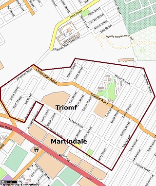
Sophiatown, also known as Sof'town or Kofifi, is a suburb of Johannesburg, South Africa. Sophiatown was a black cultural hub that was destroyed under apartheid, It produced some of South Africa's most famous writers, musicians, politicians and artists. Rebuilt under the name of Triomf, and in 2006 officially returned to its original name. Sophiatown was one of the oldest black areas in Johannesburg and its destruction represents some of the excesses of South Africa under apartheid.

Meadowlands is a suburb of Soweto, Gauteng Province, South Africa. It was founded in the early 1950s during the apartheid era for black residents from Sophiatown.

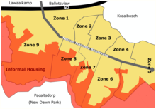
Sebokeng locally called Zweni by residents, is a middle-class township in the Emfuleni Local Municipality in southern Gauteng, South Africa near the industrial cities of Vanderbijlpark and Vereeniging. Other neighboring townships include Evaton to the north and Sharpville to the south.

<span class="mw-page-title-main">District Six</span> Former area of Cape Town, South Africa

District Six is a former inner-city residential area in Cape Town, South Africa. Over 60,000 of its inhabitants were forcibly removed during the 1970s by the apartheid regime.

Inanda or eNanda is a township in KwaZulu-Natal, South Africa that is situated 30 km north-west of the Durban CBD; it forms part of eThekwini, the Greater Durban Metropolitan Municipality. Populated primarily by Zulu-speaking Black Africans, Inanda Township is the home of John Langalibalele Dube, first president of the African National Congress (ANC), as a residence/base of operations of Mahatma Gandhi, and as birthplace of the syncretic Nazareth Baptist Church

<span class="mw-page-title-main">George Local Municipality</span> Local municipality in Western Cape, South Africa

George Municipality is a municipality located in the Western Cape Province of South Africa. As of 2011 the population is 193,672. Its municipality code is WC044.

<span class="mw-page-title-main">Gqeberha</span> City in Eastern Cape, South Africa

Gqeberha or Port Elizabeth, colloquially often referred to as P.E., is a major seaport and the most populous city in the Eastern Cape province of South Africa. It is the seat of the Nelson Mandela Bay Metropolitan Municipality, South Africa's second-smallest metropolitan district by area size. It is the sixth-most populous city in South Africa and is the cultural, economic and financial centre of the Eastern Cape.

<span class="mw-page-title-main">Apartheid</span> South African system of racial separation

Apartheid was a system of institutionalised racial segregation that existed in South Africa and South West Africa from 1948 to the early 1990s. Apartheid was characterised by an authoritarian political culture based on baasskap, which ensured that South Africa was dominated politically, socially, and economically through minoritarianism by the nation's dominant minority white population. According to this system of social stratification, white citizens had the highest status, followed by Indians and Coloureds, then black Africans. The economic legacy and social effects of apartheid continue to the present day, particularly inequality.

<span class="mw-page-title-main">Pageview, Johannesburg</span> Place in Gauteng, South Africa

Pageview is a suburb of Johannesburg, South Africa. It is located in Region F of the City of Johannesburg Metropolitan Municipality. Populated by non-whites, predominantly Indians, until the 1970s, it was one of two adjacent suburbs commonly known as Fietas.

Group Areas Act was the title of three acts of the Parliament of South Africa enacted under the apartheid government of South Africa. The acts assigned racial groups to different residential and business sections in urban areas in a system of urban apartheid. An effect of the law was to exclude people of color from living in the most developed areas, which were restricted to Whites. It required many people of color to commute large distances from their homes to be able to work. The law led to people of color being forcibly removed for living in the "wrong" areas. The majority that was people of color, were given much smaller areas to live in than the white minority who owned most of the country. Pass Laws required people of color to carry pass books and later "reference books", similar to passports, to enter the "white" parts of the country.

New Brighton is a township in the Eastern Cape, South Africa. It forms part of the greater township of Ibhayi and the Nelson Mandela Bay Metropolitan Municipality which governs Port Elizabeth and its surroundings.

Cato Manor is a working-class area located 7 kilometres (4.3 mi) from the city centre of Durban, South Africa.

<span class="mw-page-title-main">Manenberg</span> Suburb of Cape Town, in Western Cape, South Africa

Manenberg is a township of Cape Town, South Africa, that was created by the apartheid government for low-income Coloured families in the Cape Flats in 1966 as a result of the forced removal campaign by the National Party. It has an estimated population of 52,000 residents. The area consists of rows of semi-detached houses and project-like flats, known as "korre". The township is located about 20 km away from the city centre of Cape Town. It is separated from neighbouring Nyanga and Gugulethu townships by a railway line to the east and from Hanover Park by the Sand Industria industrial park to the west and Heideveld to the north. The northern part of Manenberg has wealthy people that are mostly Muslims. The rest of Manenberg has poor people that are mostly associated with Christianity.

<span class="mw-page-title-main">Internal resistance to apartheid</span> 1950–1994 social movement in South Africa

Internal resistance to apartheid in South Africa originated from several independent sectors of South African society and took forms ranging from social movements and passive resistance to guerrilla warfare. Mass action against the ruling National Party (NP) government, coupled with South Africa's growing international isolation and economic sanctions, were instrumental in leading to negotiations to end apartheid, which began formally in 1990 and ended with South Africa's first multiracial elections under a universal franchise in 1994.

<span class="mw-page-title-main">Vrededorp, Gauteng</span> Place in Gauteng, South Africa

Vrededorp is a suburb of Johannesburg, South Africa. It is located in Region F of the City of Johannesburg Metropolitan Municipality. Vrededorp is situated on the North-Western side of Johannesburg and is 1,764 m (5,788 ft) above sea level.

Noordgesig is a township in Soweto, situated at the edge of area's northernmost boundary, but within its territory. It is the first township seen on entering Soweto from the frequently used New Canada Road. Noordgesig is a Coloured township. It is colloquially called "Bulte"(meaning Hills) by its residence and neighbors, as depicted by the Mine Dumps surrounding the Township. The name "Bulte" was coined as a form of endearment by the residence for the longest time.

Red Location, Ilali Ebomvu, is one of the oldest townships in South Africa. It is situated in the township of New Brighton in Nelson Mandela Bay, Eastern Cape. It is commonly described as 'the umbilical cord of New Brighton'. It has its characteristic red appearance due to the corrugated deep red structures of the settlement which date back to the early twentieth century. These corrugated iron structures were sourced from a de-constructed concentration camp established in Uitenhage during the South African War. The recycled structures were painted red and consequently the oldest section of New Brighton became known as the Red Location. The township was aimed at housing black people and started development in 1902. Many prominent political and cultural South African leaders were born or spent time in the township.

References

  1. 1 2 3 4 Main Place Thembalethu from Census 2011.
  2. "1879. Native Locations Act - The O'Malley Archives". omalley.nelsonmandela.org. Retrieved 29 May 2020.
  3. "Control: 1910 - 1948 | South African History Online". www.sahistory.org.za. Retrieved 29 May 2020.
  4. "Group Areas Act of 1950 | South African History Online". www.sahistory.org.za. Retrieved 29 May 2020.