
Himachal Pradesh is a state in the northern part of India. Situated in the Western Himalayas, it is one of the thirteen mountain states and is characterized by an extreme landscape featuring several peaks and extensive river systems. Himachal Pradesh is the northernmost state of India and shares borders with the union territories of Jammu and Kashmir and Ladakh to the north, and the states of Punjab to the west, Haryana to the southwest, Uttarakhand to the southeast and a very narrow border with Uttar Pradesh to the south. The state also shares an international border to the east with the Tibet Autonomous Region in China. Himachal Pradesh is also known as Dev Bhoomi, meaning 'Land of Gods' and Veer Bhoomi which means 'Land of the Brave'.

Shimla is the capital and the largest city of the northern Indian state of Himachal Pradesh. In 1864, Shimla was declared as the summer capital of British India. After independence, the city became the capital of East Punjab and was later made the capital city of Himachal Pradesh. It is the principal commercial, cultural and educational centre of the state.

Manali is a town, near Kullu town in Kullu district in the Indian state of Himachal Pradesh. It is situated in the northern end of the Kullu Valley, formed by the Beas River. The town is located in the Kullu district, approximately 270 kilometres (170 mi) north of the state capital of Shimla and 544 kilometres (338 mi) northeast of the national capital of New Delhi. With a population of 8,096 people recorded in the 2011 Indian census Manali is the beginning of an ancient trade route through Lahaul (H.P) and Ladakh, over the Karakoram Pass and onto Yarkand and Hotan in the Tarim Basin of China. Manali is a popular tourist destination in India and serves as the gateway to the Lahaul and Spiti district as well as the city of Leh in Ladakh.

Nahan is a town in Himachal Pradesh in India and is the headquarters of the Sirmaur District It was the capital of the former Sirmur princely state.Nahan is also known as the Town of ponds.
Bilaspur is a town and a municipal council in Bilaspur district in the Indian state of Himachal Pradesh.
Nalagarh is a city and a municipal committee, near the city of Solan in Solan district in the Indian state of Himachal Pradesh.
The Hill States of India were princely states lying in the northern border regions of the British Indian Empire.

Shimla district is one of the twelve districts of the state of Himachal Pradesh in northern India. Its headquarters is the state capital of Shimla. Neighbouring districts are Mandi and Kullu in the north, Kinnaur in the east, Uttarakhand in the southeast, Solan to the southwest and Sirmaur in the south. The elevation of the district ranges from 987 metres (3,238 ft) to 4,500 metres (14,764 ft).
Dagshai, also known as Daagh-e-Shahi, is one of the oldest cantonment towns in the Solan district of Himachal Pradesh, India. It is situated on top of a 5,689-foot (1,734-m) high hillock that stands sphinx-like astride the Kalka-Shimla Highway at a point about 11 km from Solan. It was founded in 1847 by the East India Company by securing free of cost five villages from Maharaja of Patiala aka Bhupinder Singh of Patiala. The names of these villages were Dabbi, Badhtiala, Chunawad, Jawag and Dagshai. The new cantonment was named after the last named village, as it was the largest and most strategically located. The name Dagshai, according to a popular local legend was derived from Daagh-e-Shahi. During the Moghul times a Daagh-e-Shahi was put on the forehead of the criminals and sent packing to the then Dagshai village.
Gagret is a nagar panchayat in Tehsil Ghanari of Una district in the state of Himachal Pradesh, India. It is situated in plains of Una.
Nurpur is a city and a municipal council in Kangra district in the Indian state of Himachal Pradesh. It was formerly part of the Nurpur State since the 11th century AD. The capital of the state was at Pathankot formerly known as Paithan, now in Punjab.It got its name from wife of Mughal emperor Jahangir, Nur Jahan, when they visited Kangra (Nagarkot) after Jahangir's successful conquest of the Kangra Fort.

Parwanoo or Parwanu is a municipal council in Solan district in the Indian state of Himachal Pradesh. It is an industrial town. It has himachal's biggest wholesale market. It borders Panchkula district of Haryana, and is after the towns of Pinjore and Kalka on the Chandigarh Simla Highway. In fact it is separated by a river bed from the town of Kalka.
Rohru is a town and a municipal committee in Shimla district in the Indian state of Himachal Pradesh. It is at the banks of the Pabbar River, and it is about 115 km from Shimla city. Rohru is at 31.202°N 77.7519°E. It has an average elevation of 1,525 metres (5,003 feet).
Sundar Nagar is a town and a municipal council in Mandi district in the Indian state of Himachal Pradesh. Formerly it was a princely state, known as Suket.
The development of tribal areas in Himachal Pradesh is one of the major steps taken by the state government for its economic development. The border districts of Kinnaur, Lahaul, Spiti and the Pangi and Bharmour tehsils of Chamba districts are the major tribal areas of the state. They are located near the borders of Tibet and Indian States of Jammu and Kashmir. Other backward areas include Shillai in Sirmaur district, and deep cut-off valleys in the Kullu and upper stretches of Kangra districts. Due to poor accessibility, life in these areas had grown in isolation.

Mandi is a major city and a municipal corporation in Mandi District in the Indian state of Himachal Pradesh.

Baragaon is a village in Kumarsain subdivision of Shimla district in the Indian state of Himachal Pradesh.

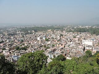
Kumarsain, also known as Kumharsain, is a sub-division, a tehsil and a village in Shimla District in the Indian state of Himachal Pradesh. Formerly under the British Raj, it was the capital of princely state of Kumharsain, which was one of the several states of the Punjab States Agency.It is about 80 km from Shimla and famous for apple and cherry orchards.
Chandel or Chandela is a Rajput clan from India. Families belonging to this clan ruled several kingdoms in north India and held various feudal estates. The most notable of these were the Chandelas of Jejakabhukti, who ruled the Bundelkhand region.
Kumarsain Assembly constituency was one of the 68 constituencies until 2008 delimitation in the Himachal Pradesh Legislative Assembly of Himachal Pradesh state in India. It was a segment of Simla Lok Sabha constituency. It included areas of Kumarsain tehsil and Sunni tehsil of Shimla district. Post 2008 delimitation, Kumarsain tehsil became part of Theog Assembly constituency and Sunni tehsil became part of Shimla Rural Assembly constituency.


