Related Research Articles

Cassiar is a ghost town in British Columbia, Canada. It was a small company-owned asbestos mining town located in the Cassiar Mountains of Northern British Columbia north of Dease Lake.
Telegraph Creek is a small community located off Highway 37 in Northern British Columbia at the confluence of the Stikine River and Telegraph Creek. The only permanent settlement on the Stikine River, it is home to approximately 250 members of Tahltan First Nation and non-native residents. The town offers basic services, including Anglican and Catholic churches, a general store, a post office, a clinic with several nurses on-call around the clock, two Royal Canadian Mounted Police officers, and a K-9 school. Steep river banks and rocky gorges form the terraced nature of the geography.
Dease Lake is a small community located in the Cassiar Country of the Northern Interior of British Columbia, Canada. It is located a few hours south of the Yukon border on Stewart–Cassiar Highway at the south end of the lake of the same name. Dease Lake is the last major centre before the Alaska Highway while driving north bound, and also the junction to Telegraph Creek and the Grand Canyon of the Stikine. Dease Lake Indian Reserve No. 9 is located nearby and is under the governance of the Tahltan First Nation band government.

The Dease River flows through northwestern British Columbia, Canada and is a tributary of the Liard River. The river descends from Dease Lake, though its ultimate origin is in the headwaters of Little Dease Creek at Snow Peak, approximately 50 kilometres (31 mi) west of the lake. The river flows 265 kilometres (165 mi) generally north-eastward, draining into the Liard River near Lower Post, British Columbia. Large sections of the river parallel the Cassiar Highway, helping to make it a popular destination for canoeists, kayaakers, and rafters.

Tā Chʼilā Provincial Park, formerly Boya Lake Provincial Park, is a provincial park located in the Stikine Region of British Columbia, Canada. The park located 120 km north-by-northwest of the community of Dease Lake near BC Highway 37. Boya Lake is named for Charlie Boya, a First Nations man from the area.

The Stikine Country, also referred to as the Stikine District or simply "the Stikine", is one of the historical geographic regions of the Canadian province of British Columbia, located inland from the central Alaska Panhandle and comprising the basin of the Stikine River and its tributaries. The term Stikine–Iskut is also fairly common to describe the area, and references the Iskut River, the Stikine's largest tributary and describable as its south fork.
The Cassiar Country, also referred to simply as the Cassiar, is a historical geographic region of the Canadian province of British Columbia. The Cassiar is located in the northwest portion of British Columbia, just to the northeast of the Stikine Country, while to the south is the Omineca Country. The area is noted for the Cassiar gold rush of the 1870s, when Laketon became its unofficial capital. The ghost town of Cassiar is also located in the Cassiar region.
Henry "Harry" McDame was a Bahamas-born prospector in the California and British Columbia gold rushes.
The Tahltan First Nation, also known as the Tahltan Indian Band, is a band government of the Tahltan people. Their main community and reserves are located at Telegraph Creek, British Columbia. Their language is the Tahltan language, which is an Athabaskan language also known as Nahanni, is closely related to Kaska and Dunneza. Their Indian and Northern Affairs Canada band number is 682. The Tahltan First Nation is joined with the Iskut First Nation in a combined tribal council-type organization known as the Tahltan Nation.
The Cottonwood River is a tributary of the Dease River in the Cassiar Country of the Northern Interior of British Columbia, Canada. Rising in the northern Stikine Ranges just east of Toozaza Peak, and just south of the origins of the Jennings and Little Rancheria River near the border with Yukon, it flows south along the east flank of the Tuya Range to meet the Dease just north of that river's source at Dease Lake, between the north end of that lake and McDame Creek and the former mining centre and community of McDame Post.
The Tuya River is a major tributary of the Stikine River in far northwestern British Columbia, Canada. Rising at Tuya Lake, which is on the south side of Tuya Mountains Provincial Park, it flows south to meet the Stikine River where that river bisects the Tahltan Highland. Its main tributary is the Little Tuya River.
The Little Tuya River is a river in far northwestern British Columbia, Canada, flowing southeast from Level Mountain on the Nahlin Plateau to meet its parent, the Tuya River, a few kilometres upstream from the latter's confluence with the Stikine River. It is the Tuya's only significant tributary.
The Red River is a tributary of the Kechika River in the far north of British Columbia, Canada, flowing east to meet the Kechika from headwaters in the Cassiar Mountains. In its middle reaches it forms the boundary between the Dease Plateau (N) and the Cassiar Mountains (S) and for its final stretch it crosses part of the Liard Plain. It is crossed by an unnamed road about 17.5 kilometres (10.9 mi) upstream from its confluence with the Kechika, and is just to the north of Aeroplane Lake.
Laketon is a locality and former mining camp on the west shore of Dease Lake in the Cassiar Country of far northern British Columbia, Canada. It is located at the mouth of Dease Creek. Once known for the hanging of two murderers and their bodies buried at the crossroad to serve as a warning to all. Gold was first found on Dease Creek in 1873, with Captain William Moore among the first to stake a claim.
Defot is a locality and former mining boomtown in the Cassiar Country of the Northern Interior of British Columbia, Canada, located west of Mount Defot.
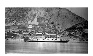
Steamboats operated on the Stikine River in response to gold finds in along that river and in the Cassiar Country of northwestern British Columbia, Canada.
McDame Creek is a creek in Cassiar Land District of British Columbia, Canada. The creek flows southeast into Dease River and is south of Good Hope Lake. The creek was discovered in 1874 by a prospector named Harry McDame. McDame Creek was mined for gold in the 19th century. A camp called Centreville contained cabins and stores and served as a trading centre for miners working on McDame Creek in the 19th century. In 1877 a 72 ounce solid gold nugget valued at $1,300 was found in McDame Creek. The solid gold nugget was found by a prospector named Al Freeman, it was the largest found in the province. This nugget was found roughly where 1st N. Fork Creek flows into McDame Creek.
Dease Creek is a creek located in the Stikine Region of British Columbia. This creek flows into the west side of Dease Lake. Dease Creek was first staked for gold in 1873 by the Moores. The creek was staked for 16 miles and in 1874 supported 700 miners. Mining companies such as Three to One, Preseverence, Canadian, Caledonia, and Baronovitch worked the creek. The total yield for the first five years was $1,054,400.00. The largest gold nugget recovered was in 1875 and weighed 50 ounces. By 1876 Chinese miners controlled most of the creek. The creek was considered to be mined out by 1880.
Defot Creek is a creek located in the Stikine Region of British Columbia. The creek is a tributary of the west fork of the Canyon River. Defot Creek is located north west of Dease Lake. The creek came to prominence when John Defot discovered gold there in 1878. Two hundred miners moved into the region and created a camp called Defot. Defot was mined using wing damming and sluicing. By 1880 fewer than 40 miners remained at the creek as the gold supply dwindled.
Gold Pan Creek is a creek located in the Cassiar Country region of British Columbia. The creek is a tributary of Little Eagle River about 10 miles east of Dease Lake. This creek was discovered in the fall of 1925 by two men named Grady and Ford. Gold was discovered in Gold Pan Creek. By the end of 1925, there were 165 claims staked on the creek. Hand sluices were used to mine the creek.
References
- ↑ N.L. Barlee (1980), The Guide to Gold Panning, Revised Second Edition, Second Printing. Canada West Publications., ISBN 0-920164-04-8