Thirkleby High and Low with Osgodby

Last updated

Thirkleby
Civil parish
Village Hall, Great Thirkleby - geograph.org.uk - 401568.jpg
Village Hall, Great Thirkleby
North Yorkshire UK location map (2023).svg
Red pog.svg
Thirkleby
Location within North Yorkshire
Population266 (2011 census) [1]
OS grid reference SE476788
Civil parish
  • Thirkleby High and Low with Osgodby
Unitary authority
Ceremonial county
Region
Country England
Sovereign state United Kingdom
Post town THIRSK
Postcode district YO7
Police North Yorkshire
Fire North Yorkshire
Ambulance Yorkshire
UK Parliament
List of places
UK
England
Yorkshire
54°12′12″N1°16′15″W / 54.203295°N 1.270723°W / 54.203295; -1.270723

Thirkleby High and Low with Osgodby is a civil parish in North Yorkshire, England. The parish includes the villages of Great Thirkleby and Little Thirkleby and the scattered hamlet of Osgodby. The similarly named medieval settlement of Thirkleby Manor is around 30 miles north, in the parish of Kirby Grindalythe, Ryedale District. [2] The population of the civil parish taken at the 2011 Census was 266. [1]

Contents

History

The Domesday Book mentions the village of Thirkleby as "Turchilebi" in the wapentake of Yarlestre and belonging to the Coxwold manor. There were 54 villagers, and the land consisted of ploughed fields and woodland. [3] At the time of the Norman invasion, the lands belonged to Kofse, but soon afterwards they were granted to Hugh, son of Baldric. [4] Soon afterwards, the manor was in the hands of the Mowbray family, and it followed the descent of the manor of Thirsk until the 16th century. A mesne lordship was held in the parish by Robert de Buscy in the 12th century, with some land granted to Byland Abbey. The Buscy family held this land until at least 1348. Other landowners in the 12th century in the manor were the Meynell family. Some of their land seems to have been granted by marriage to the de Burton family, who also held lands in West Harlsey. [5]

The greater manor passed from the Buscy family to the Crown following their involvement in the 1322 uprisings. They were acquired by Sir Thomas Ughtred in 1361. The manor was sold to Sir Roger Fulthorpe in 1383 and remained in the family until the late 16th century, when it was seized by the Crown. It was subsequently sold to the Earl of Warwick, who sold it in turn to William Frankland. It remained in the Frankland family, though not always in the direct line of succession, until the late 19th century. [6]

The lesser manor passed from the de Burton family to Marmaduke Darell in 1363 and thereafter followed the inheritance of the manor of Sessay. The lands that make up Osgodby were those that were granted to the church. [6]

The toponymy is derived from the Danish personal name of Thorkel or Thirkel, suffixed with by to give the meaning of Thorkel's farm. [7]

Thirkleby Hall used to stand to the west of Great Thirkleby. It was built between 1780 and 1785 for Sir Thomas Frankland, 6th Baronet and was situated in around 200 acres (81 ha) of grounds. At the end of the First World War, the estate was without any heir and was auctioned off, except for the hall which did not find a buyer until 1927 when it was dismantled entirely. The grounds are now used for holiday accommodation in the form of cottages and static caravans. [8] [9]

Prisoner of war camp number 108 was built at Sandhill (on Low Road at the southern edge of Little Thirkleby) as a working camp for German prisoners during the Second World War. [10] It has been used as a pig farm for many years, but the water tower and many of the buildings have survived.

A Roman fort was discovered at Thirkleby in 2018, through the study of aerial photography. The fort is considered to date to the Flavian period on the basis of its layout. [11]

Governance

The village lies within the Thirsk and Malton UK Parliament constituency. [12] It also lies within the Stillington electoral division of North Yorkshire County Council and the White Horse ward. [13] [ not specific enough to verify ]

Geography

View of Great Thirkleby towards The White Horse at Kilburn Great Thirkleby.jpg
View of Great Thirkleby towards The White Horse at Kilburn

The parish is 2,592 acres (1,049 ha) in size. The parish consists of the villages of Great (or High) Thirkleby and Little (or Low) Thirkleby, and the scattered hamlet of Osgodby. Thirkleby Beck divides Great and Little Thirkleby and runs south as part of the tributary system of the River Swale. The A19 road passes north-westward through the southern part of the parish. The two villages are linked by Arden Bridge, which is a Grade II listed structure probably built by John Carr in the 18th century. [14] [13]

The nearest settlements to the centre point of the two villages are Bagby 1.3 miles (2.1 km) to the north-west, Kilburn 2.3 miles (3.7 km) to the east, Carlton Husthwaite 1.8 miles (2.9 km) to the south-east and Hutton Sessay 1.5 miles (2.4 km) to the south. [13]

Demography

In 1881, the UK Census recorded the population as 261. [7] In 2001 the UK Census recorded a population of 224, of whom 47.8% were male and 52.2% were female, and 191 were over the age of sixteen years. [15] The 2011 UK Census recorded a population of 266, of which 47.4% were male and 52.6% were female and 232 were over the age of sixteen years. Population density was recorded as 0.2 per hectare. [1]

Religion

All Saints, Great Thirkleby, Thirsk, North Yorkshire All Saints Thirkleby.jpg
All Saints, Great Thirkleby, Thirsk, North Yorkshire

The church is a Grade II* listed building, dedicated to All Saints. It was designed by Victorian architect Edward Buckton Lamb and built in 1851 for Lady Frankland-Russell of Thirkleby Park, in memory of her husband Robert. The burial vault of the earlier church was retained but the fine pews were moved to the church of St Andrew's at Blubberhouses (another Frankland-Russell estate church also designed by E. B. Lamb). All Saints has several Frankland memorials and other monumental inscriptions, including a fine piece by the sculptor John Flaxman. [16]

The previous church was rebuilt in 1722 on the site of the original 12th-century building. [17] [7] [6]

Notable residents

Memorial to Sir Thomas Frankland's children by John Flaxman R.A. Frankland memorial by John Flaxman R.A..jpg
Memorial to Sir Thomas Frankland's children by John Flaxman R.A.

Related Research Articles

<span class="mw-page-title-main">Sowerby, North Yorkshire</span> Village and civil parish in North Yorkshire, England

Sowerby is a village, electoral ward and civil parish in the Hambleton District of North Yorkshire, England immediately south of the neighbouring market town of Thirsk. Although the boundary between the two parishes runs very close to Thirsk town centre, the village retains its own identity and has a separate Parish Council. The author James Herriot lived in the village.

<span class="mw-page-title-main">Kilburn, North Yorkshire</span> Village in North Yorkshire, England

Kilburn is a village in the civil parish of Kilburn High and Low, in the Hambleton District in the county of North Yorkshire, England. It lies on the edge of the North York Moors National Park, and 6.2 miles (10 km) north of Easingwold.

<span class="mw-page-title-main">Barlby</span> Village in North Yorkshire, England

Barlby is a linear village in the civil parish of Barlby with Osgodby, in North Yorkshire, England. It is situated 2 miles (3 km) to the north-east of the market town of Selby, and is bordered to the west by the River Ouse and to the east by the A19 Barlby bypass. Across the bypass is Barlby's smaller sister village, Osgodby.

<span class="mw-page-title-main">Boltby</span> Village and civil parish in North Yorkshire, England

Boltby is a village and civil parish in the Hambleton District of North Yorkshire, England. It is on the edge of the North York Moors National Park at 460 feet (140 m), and about six miles (9.7 km) north-east of Thirsk. According to the 2011 census, it had a population of 143.

<span class="mw-page-title-main">Brompton, east North Yorkshire</span> Civil parish in North Yorkshire, England

Brompton is a civil parish in the Scarborough district of North Yorkshire, England, containing the villages of Brompton-by-Sawdon and Sawdon.

<span class="mw-page-title-main">Carlton Husthwaite</span> Village and civil parish in North Yorkshire, England

Carlton Husthwaite is a village and civil parish in the Hambleton district of North Yorkshire, England, about seven miles south-east of Thirsk. According to the 2001 census it had a population of 167, increasing to 180 at the 2011 Census.

<span class="mw-page-title-main">Thormanby</span> Village and civil parish in North Yorkshire, England

Thormanby is a village and civil parish in Hambleton District of North Yorkshire, England. It lies on the A19 approximately halfway between Easingwold and Thirsk and about 14 miles (23 km) south east of the county town of Northallerton.

<span class="mw-page-title-main">Oulston</span> Village and civil parish in North Yorkshire, England

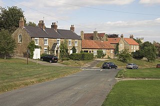
Oulston is a village and civil parish in Hambleton district of North Yorkshire, England. It lies about 3 miles (5 km) north-east of Easingwold. Remains of a Roman villa have been found in the area. The village is within the Howardian Hills Area of Outstanding Natural Beauty

<span class="mw-page-title-main">Hutton Sessay</span> Village and civil parish in North Yorkshire, England

Hutton Sessay is a village and civil parish in the Hambleton district of North Yorkshire, England. In 2013 the population of the civil parish was estimated at 100. The village is situated just west of the A19 between Thirsk and Easingwold.

<span class="mw-page-title-main">Topcliffe, North Yorkshire</span> Village and civil parish in North Yorkshire, England

Topcliffe is a village and civil parish in the Hambleton district of North Yorkshire, England. The village is situated on the River Swale, on the A167 road and close to the A168. It is about 5 miles (8 km) south-west of Thirsk and 11 miles (18 km) south of the county town of Northallerton. It has a population of 1,489. An army barracks, with a Royal Air Force airfield enclosed within, is located to the north of the village.

<span class="mw-page-title-main">Slingsby, North Yorkshire</span> Village and civil parish in North Yorkshire, England

Slingsby is a village and civil parish in North Yorkshire, England, 6 miles (10 km) west of Malton on the B1257 road. At the 2001 Census, it had a population of 634, increasing to 665 at the 2011 Census.

<span class="mw-page-title-main">West Tanfield</span> Village and civil parish in North Yorkshire, England

West Tanfield is a village and civil parish in the Hambleton district of North Yorkshire, England. The village is situated approximately six miles north of Ripon on the A6108, which goes from Ripon to Masham and Wensleydale. The parish includes the hamlets of Nosterfield, Thornborough and Binsoe.

<span class="mw-page-title-main">Sessay</span> Village and civil parish in North Yorkshire, England

Sessay is a small, linear village and civil parish in North Yorkshire, England. It is situated approximately 4 miles (6 km) south-east from Thirsk, and 2 miles (3 km) west from the A19 road close to the East Coast Main Line.

<span class="mw-page-title-main">Cowesby</span> Village and civil parish in North Yorkshire, England

Cowesby is a village and civil parish in the Hambleton District of North Yorkshire, England. Part of the village including The Cowesby Hall Estate is within the North York Moors National Park and about 7 miles (11 km) north of Thirsk. The population of the civil parish was estimated at 70 in 2014.

<span class="mw-page-title-main">Kirby Knowle</span> Village and civil parish in North Yorkshire, England

Kirby Knowle is a village and civil parish in Hambleton District of North Yorkshire, England, on the border of the North Yorkshire Moors and near Upsall, about four miles northeast of Thirsk. Historically part of the North Riding of Yorkshire, the population of the civil parish was estimated at 60 in 2014.

<span class="mw-page-title-main">Myton-on-Swale</span> Village and civil parish in North Yorkshire, England

Myton-on-Swale is a village and civil parish in North Yorkshire, England. It is about 3 miles east of Boroughbridge and on the River Swale.

<span class="mw-page-title-main">Over Silton</span> Village and civil parish in North Yorkshire, England

Over Silton is a village and civil parish in the Hambleton district of North Yorkshire, England, about 6 miles (9.7 km) east of Northallerton and on the border of the North York Moors. The population taken at the 2011 Census was less than 100, and so detailed information is included in the civil parish of Nether Silton. The population was estimated to be 70 at the time of the 2011 census by North Yorkshire County Council. This had dropped to 60 by 2015.

<span class="mw-page-title-main">Terrington</span> Village and civil parish in North Yorkshire, England

Terrington is a village and civil parish in the Ryedale district of North Yorkshire, England. It is situated in the Howardian Hills, 4 miles (6.4 km) west of Malton.

<span class="mw-page-title-main">Appleton-le-Street</span> Village in North Yorkshire, England

Appleton-le-Street is a small village and in the Ryedale district of North Yorkshire, England. It is approximately 3 miles (5 km) west of Malton and in the parish of Appleton-le-Street with Easthorpe.

<span class="mw-page-title-main">Huttons Ambo</span> Civil parish in North Yorkshire, England

Huttons Ambo is a civil parish in the Ryedale district of North Yorkshire, England. It is about 14 miles (22.5 km) north-east of York and 3 miles (4.8 km) south-west of Malton. The civil parish of Huttons Ambo consists of the villages of High Hutton and Low Hutton.

References

  1. 1 2 3 UK Census (2011). "Local Area Report – Thirkleby High and Low with Osgodby Parish (1170216937)". Nomis. Office for National Statistics . Retrieved 13 June 2018.
  2. Historic England. "Thirkleby Manor (1019094)". National Heritage List for England . Retrieved 8 September 2013.
  3. Morris, John, ed. (1986). Domesday Book Yorkshire. Chichester: Phillimore. p. 327B.
  4. Thirkleby in the Domesday Book . Retrieved 10 February 2013.
  5. Page, William, ed. (1968). The Victoria history of the county of York, North Riding. London: Dawsons of Pall Mall for the University of London Institute of Historical Research. p. 56. ISBN   0712903100.
  6. 1 2 3 "Parishes: Thirkleby | British History Online". www.british-history.ac.uk. Retrieved 12 June 2023.
  7. 1 2 3 Bulmer's Topography, History and Directory (Private and Commercial) of North Yorkshire 1890. S&N Publishing. 1890. pp. 812–813. ISBN   1-86150-299-0.
  8. "Hall and Grounds" . Retrieved 10 February 2013.
  9. "Thirkleby Hall Caravan Park".
  10. "English Heritage list of POW camps (1939–1948)" . Retrieved 8 September 2013.
  11. Millett, Martin; Brickstock, Richard (2020). "An Early Roman Fort at Thirkleby, North Yorkshire". Britannia. 51: 318–323. doi: 10.1017/S0068113X20000021 . ISSN   0068-113X.
  12. "Election Maps". ordnancesurvey.co.uk. Retrieved 12 June 2023.
  13. 1 2 3 "OpenData support | OS Tools & Support".
  14. Historic England. "ARDEN BRIDGE OVER THIRKLEBY BECK (1191018)". National Heritage List for England . Retrieved 1 October 2022.
  15. UK Census (2001). "Local Area Report – Thirkleby High and Low with Osgodby Parish (36UC149)". Nomis. Office for National Statistics . Retrieved 1 October 2022.
  16. "Thirkleby All Saints". nationalchurchestrust.org. Retrieved 12 June 2023.
  17. Historic England. "CHURCH OF ALL SAINTS (1315254)". National Heritage List for England . Retrieved 1 October 2022.
  18. Pearson, A. W. H. (23 September 2004). "Frankland, Sir Thomas, fifth baronet". Oxford Dictionary of National Biography (online ed.). Oxford University Press. doi:10.1093/ref:odnb/10087.(Subscription or UK public library membership required.)