
Bowfell is a pyramid-shaped mountain lying at the heart of the English Lake District, in the Southern Fells area. It is the sixth-highest mountain in the Lake District and one of the most popular of the Lake District fells for walkers. It is listed in Alfred Wainwright's 'best half dozen' Lake District fells.
Pavey Ark is a fell in the English county of Cumbria. It is one of the Langdale Pikes, lying to the north of Great Langdale, in the heart of the Lake District, immediately to the north-east of Harrison Stickle.

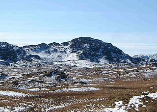
Cold Pike is a fell in the English Lake District. It is a satellite of Crinkle Crags and stands above the Upper Duddon Valley.

High Raise is a fell in the Central Fells of the English Lake District, not to be confused with another High Raise situated in the Far Eastern Fells. High Raise is not one of the most spectacular mountains in the district; however, with a height of 762 metres (2,500 ft) it is the highest point in the central fells of Lakeland.

Great Langdale is a valley in the Lake District National Park in North West England, the epithet Great distinguishing it from the neighbouring valley of Little Langdale. Langdale is also the name of a valley in the Howgill Fells, elsewhere in Cumbria.

Loft Crag is a fell in the English Lake District, situated 9 kilometres west of Ambleside in the valley of Great Langdale. Along with the neighbouring fells of Harrison Stickle and Pike of Stickle it forms the picturesque Langdale Pikes, which when viewed from the area around Elterwater village gives one of the best-known views in the National Park.

Pike of Stickle, also known as Pike o’ Stickle, is a fell in the English Lake District. It reaches a height of 709 metres (2,326 feet) and is situated in the central part of the national park in the valley of Great Langdale. The fell is one of three fells which make up the picturesque Langdale Pikes, one of the best-known areas in Lakeland. A "stickle" is a hill with a steep prominent rocky top, while a "pike" is a hill with a peaked summit, the name being therefore partly tautological.

Pike of Blisco, or Pike o' Blisco, is a mountain in the Lake District in Cumbria, England. Located between the valleys of Great Langdale and Little Langdale, its relative isolation from neighbouring fells together with slopes falling away immediately from the summit in all directions mean it has excellent views: the view of the Langdale Pikes across Great Langdale is particularly arresting.

Harrison Stickle is a fell in the central part of the English Lake District, situated above Great Langdale. The fell is one of the three fells which make up the picturesque Langdale Pikes, the others being Pike of Stickle and Loft Crag. Together they make up one of the most picturesque, and probably the best-known, mountain groups in the District. A "stickle" is a hill with a prominent rocky top.

Sergeant Man is a fell in the English Lake District. It is properly a secondary summit of High Raise, but is given a separate chapter by Alfred Wainwright in his third Pictorial Guide nonetheless, as it "is so prominent an object and offers so compelling a challenge". Its rocky cone is indeed in great contrast to the grassy dome of High Raise.
Great Crag is a fell in the English Lake District, located near the hamlets of Rosthwaite and Stonethwaite in Borrowdale.

Tarn Crag is a fell in the Central Fells of the English Lake District. Strictly the name refers only to the rock face looking down upon Easedale Tarn, but Alfred Wainwright applied it to the entire ridge lying between the Easedale and Far Easedale valleys in his Pictorial Guide to the Lakeland Fells
Blea Rigg is a fell in the English Lake District, lying between the valleys of Easedale and Great Langdale. One of the Central Fells, it is a broad plateau with a succession of rocky tops. Many routes of ascent are possible, beginning either from Grasmere or Great Langdale, though the paths are often poorly marked and hard to follow.

Lingmoor Fell is a fell in the English Lake District, situated eight kilometres west of Ambleside. The fell reaches a height of 469 m (1,540 ft) and divides the valleys of Great Langdale and Little Langdale. The fell's name originates from the Old Norse word lyng meaning “heather covered”. The actual summit of the fell is named as Brown How on Ordnance Survey maps.

Rossett Pike is a fell in the English Lake District. It is located at the head of Mickleden, one of two tributary valleys of Great Langdale.

The Far Eastern Fells are a group of hills in the English Lake District. Reaching their highest point at High Street, they occupy a broad area to the east of Ullswater and Kirkstone Pass. Much quieter than the central areas of Lakeland they offer in general easier walking as the fells merge mainly into the surrounding moorlands.
The Central Fells are a group of hills in the English Lake District. Reaching their highest point at High Raise, they occupy a broad area to the east of Borrowdale. The Central Fells are generally lower than the surrounding hills, the Lake District's dome-like structure having a slight dip in the middle. The range extends from the boggy ridge between Derwentwater and Thirlmere in the north, to the rock peaks of the Langdale Pikes in the south.

The Southern Fells are a group of hills in the English Lake District. Including Scafell Pike, the highest peak in England, they occupy a broad area to the south of Great Langdale, Borrowdale and Wasdale. High and rocky towards the centre of the Lake District, the Southern Fells progressively take on a moorland character toward the south-west. In the south-east are the well-known Furness Fells, their heavily quarried flanks rising above Coniston Water.

Chapel Stile is a village in Cumbria, England, located approximately 5 miles northwest of Ambleside, within the Langdale valley. It contains a school, Holy Trinity church, the Co-op and the Wainwrights' Inn, and a quarry is located in the vicinity.


