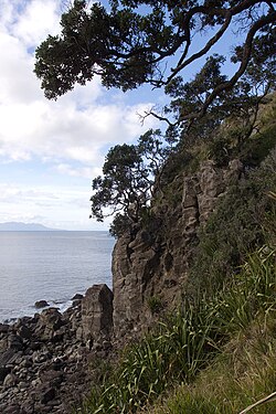
Ti Point

Last updated

Ti Point
Ti Point (7340765852).jpg
Ti Point
Ti Point
Coordinates: 36°19′02″S174°47′24″E / 36.317159°S 174.790026°E / -36.317159; 174.790026
Country New Zealand
Region Auckland Region
Ward Rodney ward
Community board Rodney Local Board
Electorates
Government
  Territorial Authority Auckland Council
Area
[1]
  Total2.29 km2 (0.88 sq mi)
Population
 (June 2023) [2]
  Total150
  Density66/km2 (170/sq mi)

Ti Point is an area off Omaha Beach in the small New Zealand village of Leigh, located in the Rodney District. Ti Point is situated very close to Leigh and Goat Island, and is just over one hour drive north of Auckland. It is used for fishing, boating, hiking, rock climbing and yachting, and is under governance of the Rodney District Council, just north of Whangateau.[ citation needed ]

Contents

Geology

Ti Point is formed from the remnants of a Miocene era volcano, which erupted between 10 and 7 million years ago. Much of the peninsula is the eroded and exhumed volcanic plumbing that remains from the volcano. [3]

History

When Europeans arrived in New Zealand, there were no Māori inhabitants of Ti Point, though there were thriving communities all around, in what would become Leigh and Omaha. The remains of an ancient Pa (a fortified camp or village) can be seen just above the point itself.[ citation needed ]

The first European to settle Ti Point was William Arthur Torkington, a builder and carpenter from Manchester, England. Several of William's descendants still live on Ti Point, and in the surrounding areas, and one of the few remaining buildings built by William, a church, can be seen in nearby Matakana, at the Matakana Country Park.[ citation needed ]

Demographics

Statistics New Zealand describes Ti Point as a rural settlement, which covers 2.29 km2 (0.88 sq mi) [1] and had an estimated population of 150 as of June 2023, [2] with a population density of 66 people per km2. Ti Point is part of the larger Cape Rodney statistical area. [4]

Historical population
YearPop.±% p.a.
200684    
2013105+3.24%
2018132+4.68%
Source: [5]

Ti Point had a population of 132 at the 2018 New Zealand census, an increase of 27 people (25.7%) since the 2013 census, and an increase of 48 people (57.1%) since the 2006 census. There were 45 households, comprising 72 males and 63 females, giving a sex ratio of 1.14 males per female. The median age was 46.0 years (compared with 37.4 years nationally), with 27 people (20.5%) aged under 15 years, 15 (11.4%) aged 15 to 29, 69 (52.3%) aged 30 to 64, and 24 (18.2%) aged 65 or older.

Ethnicities were 93.2% European/Pākehā, 6.8% Māori, 4.5% Pacific peoples, 2.3% Asian, and 4.5% other ethnicities. People may identify with more than one ethnicity.

Although some people chose not to answer the census's question about religious affiliation, 79.5% had no religion, 11.4% were Christian and 4.5% had other religions.

Of those at least 15 years old, 27 (25.7%) people had a bachelor's or higher degree, and 9 (8.6%) people had no formal qualifications. The median income was $29,200, compared with $31,800 nationally. 18 people (17.1%) earned over $70,000 compared to 17.2% nationally. The employment status of those at least 15 was that 42 (40.0%) people were employed full-time, 21 (20.0%) were part-time, and 3 (2.9%) were unemployed. [5]

Wine-making

Since the late 1990s, wine has been produced at the Ti Point Winery, in the Matakana wine region. [6] [7] Their wines have won gold medals at several wine shows, including the Spiegelau International Wine Competition and the New Zealand International Wine Show. [8] [9]

Amenities

The Ti Point Walkway follows the southern coast of Ti Point, traversing coastal bush and beaches. [10]

Ti Point Reptile Park

Ti Point Reptile Park is the only zoo in New Zealand specialising in reptiles. [11] Ivan Borich founded the park in 1972 and still privately owns and operates it as of September 2020. [12]

The park contains a wide variety of reptiles, including tortoise, lizards, and Tuatara – a species of lizard only found in New Zealand.

Although the park specialises and contains predominantly reptiles, the park began as a traditional zoo, and still houses Capuchin monkeys and a Cockatoo. [13]

Related Research Articles

<span class="mw-page-title-main">Tasman District</span> Government district of New Zealand

Tasman District is a local government district in the northwest of the South Island of New Zealand. It borders the Canterbury Region, West Coast Region, Marlborough Region and Nelson City. It is administered by the Tasman District Council, a unitary authority, which sits at Richmond, with community boards serving outlying communities in Motueka and Golden Bay / Mohua. The city of Nelson has its own unitary authority separate from Tasman District, and together they comprise a single region in some contexts, but not for local government functions or resource management (planning) functions.

<span class="mw-page-title-main">Auckland Region</span> Region of New Zealand

Auckland is one of the 16 regions of New Zealand, which takes its name from the eponymous urban area. The region encompasses the Auckland metropolitan area, smaller towns, rural areas, and the islands of the Hauraki Gulf. Containing 33 percent of the nation's residents, it has by far the largest population and economy of any region of New Zealand, but the second-smallest land area.

<span class="mw-page-title-main">Ward, New Zealand</span> Town in Marlborough, New Zealand

Ward is a small town in Marlborough, New Zealand. It is located on State Highway 1, 82 kilometres (51 mi) north of Kaikōura. The Flaxbourne River flows past to the north and into the Pacific Ocean at Ward Beach to the south-east of Ward. A current initiative aims to have the town renamed as Flaxbourne.

<span class="mw-page-title-main">Leigh, New Zealand</span> Place in Auckland Region, New Zealand

Leigh is a small coastal community in the north of the Auckland Region of New Zealand. It lies on the west side of Omaha Cove, a small inlet within Ōmaha Bay to the south of Cape Rodney. It is 13 km from Matakana, 21 km from Warkworth and approximately 92 km north of Auckland City.

<span class="mw-page-title-main">Ōmaha</span> Locality in Auckland Region, New Zealand

Ōmaha is a small beach town on Ōmaha Bay in the Auckland Region, in the north of New Zealand. It is located 74.7 km north of central Auckland. It is on a sandspit that adjoins Tāwharanui Peninsula and separates Whangateau Harbour from Ōmaha Bay. The nearest sizeable town is Warkworth which is situated 16.8 km south west of Ōmaha.

<span class="mw-page-title-main">Whangateau</span> Place in Auckland Region, New Zealand

Whangateau is a small town on the east coast of the North Island of New Zealand. It is situated in Rodney District, part of the Auckland Region, and is on a peninsula stretching out into the Hauraki Gulf, north of Auckland. Whangateau is on the northern shore of Whangateau Harbour which is fed by the Ōmaha River and separated from Ōmaha Bay by the Maungatawhiri sandspit. The settlement is in two parts of 20 to 30 houses each. The main settlement includes a large public reserve with sports fields and a campground. There is also a public hall which hosts music events and a flax weaving group. The smaller settlement is Tram Car Bay, named for two tram cars which were used as holiday homes. Whangateau is situated between the rural settlement of Matakana and the fishing village of Leigh. A tsunami siren is located in the town.

<span class="mw-page-title-main">Stillwater, Auckland</span> Suburb in Auckland, New Zealand

Stillwater is a village in the northern end of Auckland in the North Island of New Zealand. Situated on the Weiti River immediately south of the Whangaparaoa Peninsula in the Rodney District, it is part of the area known as the Hibiscus Coast. There is also a Stillwater, West Coast in the South Island.

<span class="mw-page-title-main">Kaipara Flats</span> Place in Auckland Region, New Zealand

Kaipara Flats is a locality in the Rodney District of New Zealand. Warkworth is 12 km to the east, Ahuroa to the south, and Tauhoa to the north-west. The North Auckland railway line passes through the area.

<span class="mw-page-title-main">Matakana</span> Place in Auckland Region, New Zealand

Matakana is a small town in the Rodney Ward of Auckland Council of New Zealand. Warkworth lies about 9 km to the south-west, Snells Beach the same distance to the south, Ōmaha is about 7 km to the east, and Leigh about 13 km to the north-east. The Matakana River flows through the town and into Kawau Bay to the south-east.

<span class="mw-page-title-main">Rodney ward</span> Ward of Auckland in New Zealand

Rodney Ward is a local government area in the northernmost part of New Zealand's Auckland Region, created along with the Auckland Council in 2010. The area was previously part of Rodney District; it does not include the Hibiscus Coast, which was also part of Rodney District but is now in Albany ward. The Rodney Local Board area has the same boundaries as Rodney Ward.

<span class="mw-page-title-main">Rodney Local Board</span> Local board of Auckland Council in New Zealand

Rodney Local Board is one of the 21 local boards of Auckland Council, and is administered by the ward councillor representing Rodney Ward. Located in the northern part of the Auckland region, it is named after the former Rodney District which existed before its amalgamation into Auckland Council in 2010. Nine elected Local Board members sit on the board.

<span class="mw-page-title-main">Ōrākei ward</span> Ward of Auckland in New Zealand

Ōrākei Ward is one of thirteen wards of Auckland Council in Auckland, New Zealand. It encompasses the neighbourhoods of Saint Heliers, Glendowie, Kohimarama, Mission Bay, Saint Johns and Meadowbank. It elects one councillor to represent the ward on the council. The councillor has oversight over the Orakei Local Board. The current councillor is Desley Simpson.

<span class="mw-page-title-main">Franklin ward</span> Ward of Auckland in New Zealand

The Franklin Ward is the southernmost ward on the Auckland Council. The Franklin ward has one local board, also called Franklin; the Franklin Local Board has three subdivisions - Wairoa, Pukekohe and Waiuku. Franklin is currently represented by Andy Baker.

<span class="mw-page-title-main">Waitematā and Gulf ward</span> Ward of Auckland in New Zealand

Waitematā and Gulf Ward is an Auckland Council ward which elects one councillor and covers the Great Barrier, Waiheke, and Waitematā Local Boards. The current councillor is Mike Lee.

<span class="mw-page-title-main">Ngākuta Bay</span> Rural settlement in Marlborough, New Zealand

Ngākuta Bay is a settlement and bay in the Marlborough Sounds, New Zealand. The bay is part of Grove Arm in Queen Charlotte Sound / Tōtaranui. Picton is about 11 km to the southeast via Queen Charlotte Drive. The bay was given its official name of Ngākuta Bay on 27 May 2021 and it has been known as Ngakuta Bay since at least 1865.

Marlborough Ridge is a subdivision of Fairhall in Marlborough, New Zealand. It is located directly west of Marlborough Golf Course, and was developed from the late 1990s. Marlborough Ridge Reserve is a small park in the subdivision.

<span class="mw-page-title-main">Rainbows End, New Zealand</span> Place in Auckland Region, New Zealand

Rainbows End is a rural settlement at the end of Green Road between the Oak River and Matakana River in Auckland Region. Matakana is 4.5 km (2.8 mi) to the north. Sandspit is across the Oak River directly south.

<span class="mw-page-title-main">Point Wells</span> Place in Auckland Region, New Zealand

Point Wells is a rural settlement in the Auckland Region of New Zealand, at the tip of a peninsula between the Ōmaha River and Whangateau Harbour. Ōmaha is across the harbour but accessible by a causeway.

<span class="mw-page-title-main">Scotts Landing</span> Place in Auckland Region, New Zealand

Scotts Landing, also called Mahurangi East, is a rural settlement in the Auckland Region of New Zealand. It is at the end of a narrow peninsula on the eastern side of Mahurangi Harbour. Algies Bay is to the north.

<span class="mw-page-title-main">Glenbrook Beach</span> Place in Auckland Region, New Zealand

Glenbrook Beach is a rural community at the northern end of a peninsula formed between the Waiuku River and Taihiki River in Auckland, New Zealand. Waiuku is 14 km south by road.

References

  1. 1 2 "ArcGIS Web Application". statsnz.maps.arcgis.com. Retrieved 12 May 2022.
  2. 1 2 "Subnational population estimates (RC, SA2), by age and sex, at 30 June 1996-2023 (2023 boundaries)". Statistics New Zealand . Retrieved 25 October 2023. (regional councils); "Subnational population estimates (TA, SA2), by age and sex, at 30 June 1996-2023 (2023 boundaries)". Statistics New Zealand . Retrieved 25 October 2023. (territorial authorities); "Subnational population estimates (urban rural), by age and sex, at 30 June 1996-2023 (2023 boundaries)". Statistics New Zealand . Retrieved 25 October 2023. (urban areas)
  3. Hayward, Bruce W. (2017). Out of the Ocean, Into the Fire. Geoscience Society of New Zealand. p. 179. ISBN   978-0-473-39596-4.
  4. 2018 Census place summary: Cape Rodney
  5. 1 2 "Statistical area 1 dataset for 2018 Census". Statistics New Zealand. March 2020. 7001159.
  6. Rebecca Gibb (10 May 2011). "Wine: Working with mum". The New Zealand Herald. Retrieved 9 August 2016.
  7. Michael Cooper (5 September 2011). Wine Atlas of New Zealand. ReadHowYouWant.com. pp. 57–60. ISBN   978-1-4596-2796-3.
  8. "Marlborough wines triumph". Stuff. 5 September 2011. Retrieved 9 August 2016.
  9. Kat Pickford (27 June 2013). "Marlborough golds at Spiegelau". Stuff. Retrieved 9 August 2016.
  10. Janssen, Peter (January 2021). Greater Auckland Walks. New Holland Publishers. p. 22. ISBN   978-1-86966-516-6. Wikidata   Q118136068.
  11. "Ti Point Reptile Park, Ti Point". Auckland. Retrieved 31 August 2020.
  12. Brown, Justin. "Creepy critter park in Leigh is a secret gem". Newsroom. Newsroom. Retrieved 31 August 2020.
  13. Easther, Elisabeth (17 May 2015). "Day-tripper: Ti Point Reptile Park, Leigh". The New Zealand Herald. Retrieved 31 August 2020.