
Sullivan County is a county in the Commonwealth of Pennsylvania. It is part of Northeastern Pennsylvania. As of the 2020 census, the population was 5,840, making it the second-least populous county in Pennsylvania. Its county seat is Laporte. The county was created on March 15, 1847, from part of Lycoming County and named for Major General John Sullivan.

The Old Red Sandstone is an assemblage of rocks in the North Atlantic region largely of Devonian age. It extends in the east across Great Britain, Ireland and Norway, and in the west along the eastern seaboard of North America. It also extends northwards into Greenland and Svalbard. These areas were a part of the ancient continent of Euramerica/Laurussia. In Britain it is a lithostratigraphic unit to which stratigraphers accord supergroup status and which is of considerable importance to early paleontology. For convenience the short version of the term, ORS is often used in literature on the subject. The term was coined to distinguish the sequence from the younger New Red Sandstone which also occurs widely throughout Britain.

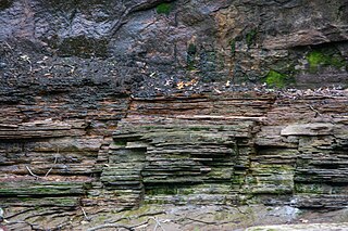
The Devonian Catskill Formation or the Catskill Clastic wedge is a unit of mostly terrestrial sedimentary rock found in Pennsylvania and New York. Minor marine layers exist in this thick rock unit. It is equivalent to the Hampshire Formation of Maryland, West Virginia, and Virginia.

Hickory Run State Park is a 15,990-acre (6,471 ha) Pennsylvania state park in Kidder and Penn Forest Townships in Carbon County, Pennsylvania in the United States. The park is spread across the Pocono Mountains. The park is easily accessible from Interstate 476 and Interstate 80.
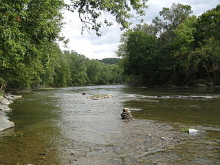
Fishing Creek is a 29.98-mile (48.25 km) long tributary of the Susquehanna River in Columbia County, Pennsylvania, in the United States. It joins the Susquehanna River near the census-designated place of Rupert and the town of Bloomsburg. The watershed has an area of 385 square miles (1,000 km2).

The Hamilton Group is a Devonian-age geological group which is located in the Appalachian region of the United States. It is present in New York, Pennsylvania, Maryland, Ohio, West Virginia, northwestern Virginia and Ontario, Canada, and is mainly composed of marine shale with some sandstone.

The Marcellus Formation or the Marcellus Shale is a Middle Devonian age unit of sedimentary rock found in eastern North America. Named for a distinctive outcrop near the village of Marcellus, New York, in the United States, it extends throughout much of the Appalachian Basin.
The Huntley Mountain Formation is a late Devonian and early Mississippian mapped bedrock unit in Pennsylvania, in the United States.

The Lock Haven Formation is a Devonian mapped bedrock unit in Pennsylvania, in the Appalachian Mountains of the United States.

The Bedford Shale is a shale geologic formation in the states of Ohio, Michigan, Pennsylvania, Kentucky, West Virginia, and Virginia in the United States.

There are 24 named waterfalls in Ricketts Glen State Park in the U.S. state of Pennsylvania along Kitchen Creek as it flows in three steep, narrow valleys, or glens. They range in height from 9 feet (2.7 m) to the 94-foot (29 m) Ganoga Falls. Ricketts Glen State Park is named for R. Bruce Ricketts, a colonel in the American Civil War who owned over 80,000 acres in the area in the late 19th and early 20th centuries, but spared the old-growth forests in the glens from clearcutting. The park, which opened in 1944, is administered by the Bureau of State Parks of the Pennsylvania Department of Conservation and Natural Resources (DCNR). Nearly all of the waterfalls are visible from the Falls Trail, which Ricketts had built from 1889 to 1893 and which the state park rebuilt in the 1940s and late 1990s. The Falls Trail has been called "the most magnificent hike in the state" and one of "the top hikes in the East".

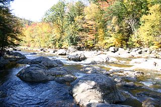
West Creek is a tributary of Fishing Creek, in Columbia County and Sullivan County, in Pennsylvania, in the United States. It is 9.1 miles (14.6 km) long and flows through Davidson Township in Sullivan County and Jackson Township, Sugarloaf Township, Benton Township, and Benton in Columbia County. The water temperature of the creek ranges from 0 °C (32 °F) to 25 °C (77 °F). The discharge ranges from nearly zero to ten cubic meters per second. Rock formations in the watershed include the Trimmers Rock Formation, the Catskill Formation, and the Huntley Mountain Formation. The creek's watershed has an area of 16.6 square miles (43 km2), most of which is agricultural, forested, or urban land. A small number of dams, mills, and schoolhouses were built on West Creek in the 19th and early 20th century. West Creek has the highest level of biodiversity of any stream in the upper Fishing Creek watershed.
The Cleveland Shale, also referred to as the Cleveland Member, is a shale geologic formation in the eastern United States.
The Kettle Point Formation, also known as the Kettle Point (black) Shale, is a geologic formation that consists of thinly laminated, siliciclastic, organic-rich black shale with thin to thick interbeds of organic-poor mudstone. It is largely restricted to the subsurface of southwestern Ontario.

Lead Run is a tributary of East Branch Fishing Creek in Sullivan County, Pennsylvania. It is approximately 1.5 miles (2.4 km) long and flows through Davidson Township. Its watershed has an area of 0.82 square miles (2.1 km2). The stream has a low pH and poor water quality, although that could potentially be remedied. The main rock formations in the area are the Catskill Formation, the Huntley Mountain Formation, and the Burgoon Sandstone. The main soil associations in the vicinity of the stream are the Deep-Wellsboro-Oquaga association, the Norwich association, and the Oquaga association.

Trout Run is a tributary of East Branch Fishing Creek in Sullivan County, Pennsylvania, in the United States. It is approximately 1.5 miles (2.4 km) long and flows through Davidson Township. The watershed of the stream has an area of 0.62 square miles (1.6 km2). The stream is acidic and is considered by the Pennsylvania Department of Environmental Protection to be impaired by atmospheric deposition and metals. Rock formations in the watershed include the Catskill Formation and the Huntley Mountain Formation. Soils in the watershed include the Deep-Wellsboro-Oquaga and Oquaga soil associations.

Big Run is a tributary of East Branch Fishing Creek in Sullivan County, Pennsylvania, in the United States. It is approximately 2.4 miles (3.9 km) long and flows through Davidson Township. Its watershed has an area of 1.38 square miles (3.6 km2). The stream has a low pH and poor water quality, although that could potentially be remedied. The main rock formations in the area are the Catskill Formation, the Huntley Mountain Formation, and the Burgoon Sandstone. The main soil associations in the vicinity of the stream are the Deep-Wellsboro-Oquaga association, the Oquaga association, and the Norwich association.
Quinn Run is a tributary of Heberly Run in Sullivan County, Pennsylvania. It is approximately 2.3 miles (3.7 km) long and flows through Davidson Township, Sullivan County, Pennsylvania. The watershed of the stream has an area of 2.31 square miles (6.0 km2). The stream is acidic and is considered by the Pennsylvania Department of Environmental Protection to be impaired by atmospheric deposition. Rock formations in the watershed include the Huntley Mountain Formation and the Burgoon Sandstone. Soils in the watershed include the Deep-Wellsboro-Oquaga soil association, and the Oquaga and Norwich soil associations. There are some waterfalls on the stream.
Pigeon Run is a tributary of Sullivan Branch in Sullivan County, Pennsylvania, in the United States. It is approximately 1.3 miles (2.1 km) long and flows through Davidson Township. Its watershed has an area of 0.78 square miles (2.0 km2). The stream has a low pH and sometimes has poor water quality, although that could potentially be remedied. The main rock formations in the area are the Catskill Formation, the Huntley Mountain Formation, and the Burgoon Sandstone. The main soil associations in the vicinity of the stream are the Deep-Wellsboro-Oquaga association, the Norwich association, the Morris association, and the Oquaga association.
Hunts Run is a tributary of Sullivan Branch in Sullivan County, Pennsylvania, in the United States. It is approximately 0.5 miles (0.80 km) long and flows through Davidson Township. Its watershed has an area of 0.40 square miles (1.0 km2). The stream has a low pH and poor water quality. The main rock formations in the area are the Huntley Mountain Formation, and the Burgoon Sandstone. The main soil associations in the vicinity of the stream are the Deep-Wellsboro-Oquaga association, the Morris association, and the Oquaga association.
Pennsylvania Department of Internal Affairs (1939), Ticklish Rock - One of State's curious formations, Pennsylvania Department of Internal Affairs Monthly Bulletin 7, no. 11, p. 3-4.


