Related Research Articles

Tides are the rise and fall of sea levels caused by the combined effects of the gravitational forces exerted by the Moon and are also caused by the Earth and Moon orbiting one another.

The tidal force is a gravitational effect that stretches a body along the line towards the center of mass of another body due to a gradient in gravitational field from the other body; it is responsible for diverse phenomena, including tides, tidal locking, breaking apart of celestial bodies and formation of ring systems within the Roche limit, and in extreme cases, spaghettification of objects. It arises because the gravitational field exerted on one body by another is not constant across its parts: the nearest side is attracted more strongly than the farthest side. It is this difference that causes a body to get stretched. Thus, the tidal force is also known as the differential force, as well as a secondary effect of the gravitational field.

An amphidromic point, also called a tidal node, is a geographical location which has zero tidal amplitude for one harmonic constituent of the tide. The tidal range for that harmonic constituent increases with distance from this point, though not uniformly. As such, the concept of amphidromic points is crucial to understanding tidal behaviour. The term derives from the Greek words amphi ("around") and dromos ("running"), referring to the rotary tides which circulate around amphidromic points.

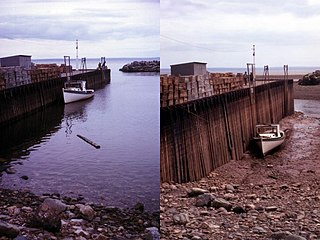
A tidal creek or tidal channel is a narrow inlet or estuary that is affected by the ebb and flow of ocean tides. Thus, it has variable salinity and electrical conductivity over the tidal cycle, and flushes salts from inland soils. Tidal creeks are characterized by slow water velocity, resulting in buildup of fine, organic sediment in wetlands. Creeks may often be a dry to muddy channel with little or no flow at low tide, but with significant depth of water at high tide. Due to the temporal variability of water quality parameters within the tidally influenced zone, there are unique biota associated with tidal creeks which are often specialised to such zones. Nutrients and organic matter are delivered downstream to habitats normally lacking these, while the creeks also provide access to inland habitat for salt-water organisms.
Phosphorite, phosphate rock or rock phosphate is a non-detrital sedimentary rock that contains high amounts of phosphate minerals. The phosphate content of phosphorite (or grade of phosphate rock) varies greatly, from 4% to 20% phosphorus pentoxide (P2O5). Marketed phosphate rock is enriched ("beneficiated") to at least 28%, often more than 30% P2O5. This occurs through washing, screening, de-liming, magnetic separation or flotation. By comparison, the average phosphorus content of sedimentary rocks is less than 0.2%. The phosphate is present as fluorapatite Ca5(PO4)3F typically in cryptocrystalline masses (grain sizes < 1 μm) referred to as collophane-sedimentary apatite deposits of uncertain origin. It is also present as hydroxyapatite Ca5(PO4)3OH or Ca10(PO4)6(OH)2, which is often dissolved from vertebrate bones and teeth, whereas fluorapatite can originate from hydrothermal veins. Other sources also include chemically dissolved phosphate minerals from igneous and metamorphic rocks. Phosphorite deposits often occur in extensive layers, which cumulatively cover tens of thousands of square kilometres of the Earth's crust.

A tidal marsh is a marsh found along rivers, coasts and estuaries which floods and drains by the tidal movement of the adjacent estuary, sea or ocean. Tidal marshes experience many overlapping persistent cycles, including diurnal and semi-diurnal tides, day-night temperature fluctuations, spring-neap tides, seasonal vegetation growth and decay, upland runoff, decadal climate variations, and centennial to millennial trends in sea level and climate.
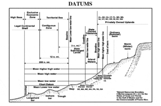
A chart datum is the water level surface serving as origin of depths displayed on a nautical chart. A chart datum is generally derived from some tidal phase, in which case it is also known as a tidal datum. Common chart datums are lowest astronomical tide (LAT) and mean lower low water (MLLW). In non-tidal areas, e.g. the Baltic Sea, mean sea level (MSL) is used. A chart datum is a type of vertical datum and must not be confused with the horizontal datum for the chart.

Tide tables, sometimes called tide charts, are used for tidal prediction and show the daily times and levels of high and low tides, usually for a particular location. Tide heights at intermediate times can be approximated by using the rule of twelfths or more accurately calculated by using a published tidal curve for the location. Tide levels are typically given relative to a low-water vertical datum, e.g. the mean lower low water (MLLW) datum in the US.
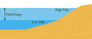
Tidal range is the difference in height between high tide and low tide. Tides are the rise and fall of sea levels caused by gravitational forces exerted by the Moon and Sun and by Earth's rotation. Tidal range depends on time and location.
A tidal river is a river whose flow and level are caused by tides. A section of a larger river affected by the tides is a tidal reach, but it may sometimes be considered a tidal river if it had been given a separate and another title name.

In geology, cross-bedding, also known as cross-stratification, is layering within a stratum and at an angle to the main bedding plane. The sedimentary structures which result are roughly horizontal units composed of inclined layers. The original depositional layering is tilted, such tilting not being the result of post-depositional deformation. Cross-beds or "sets" are the groups of inclined layers, which are known as cross-strata.
Botn is an inland fjord in the Rissa area of the municipality of Indre Fosen in Trøndelag county, Norway. It flows through a short, small river into the Sundsbukta, a small bay off the Trondheimsfjorden. The village of Årnset lies on the north shore of Botn.
Earth tide is the displacement of the solid earth's surface caused by the gravity of the Moon and Sun. Its main component has meter-level amplitude at periods of about 12 hours and longer. The largest body tide constituents are semi-diurnal, but there are also significant diurnal, semi-annual, and fortnightly contributions. Though the gravitational force causing earth tides and ocean tides is the same, the responses are quite different.
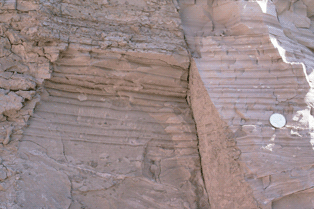
A rhythmite consists of layers of sediment or sedimentary rock which are laid down with an obvious periodicity and regularity. They may be created by annual processes such as seasonally varying deposits reflecting variations in the runoff cycle, by shorter term processes such as tides, or by longer term processes such as periodic floods.
The theory of tides is the application of continuum mechanics to interpret and predict the tidal deformations of planetary and satellite bodies and their atmospheres and oceans under the gravitational loading of another astronomical body or bodies.

A king tide is an especially high spring tide, especially the perigean spring tides which occur three or four times a year. King tide is not a scientific term, nor is it used in a scientific context.

Sedimentary structures include all kinds of features in sediments and sedimentary rocks, formed at the time of deposition.

In astronomy, a syzygy is a roughly straight-line configuration of three or more celestial bodies in a gravitational system.

A river plume is a freshened water mass that is formed in the sea as a result of mixing of river discharge and saline seawater. River plumes are formed in coastal sea areas at many regions in the World. River plumes generally occupy wide, but shallow sea surface layer bounded by sharp density gradient. The area of a river plume is 3-5 orders of magnitude greater than its depth, therefore, even small rivers with discharge rates ~1–10 m/s form river plumes with horizontal spatial extents ~10–100 m. Areas of river plumes formed by the largest World rivers are ~100–1000 km2. Despite relatively small volume of total freshwater runoff to the World Ocean, river plumes occupy up to 21% of shelf areas of the World Ocean, i.e., several million square kilometers.

A hapua is a river-mouth lagoon on a mixed sand and gravel (MSG) beach, formed at the river-coast interface where a typically braided, although sometimes meandering, river interacts with a coastal environment that is significantly affected by longshore drift. The lagoons which form on the MSG coastlines are common on the east coast of the South Island of New Zealand and have long been referred to as hapua by the Māori. This classification differentiates hapua from similar lagoons located on the New Zealand coast termed waituna.
References
- ↑ Davis, R.A. (2011). "Tidal Signatures and Their Preservation Potential in Stratigraphic Sequences". In Davis R.A. & Dalrymple R.W. (ed.). Principles of Tidal Sedimentology. Springer. pp. 49–50. ISBN 978-94-007-0122-9.
| | This sedimentology article is a stub. You can help Wikipedia by expanding it. |