A caldera is a large cauldron-like hollow that forms shortly after the emptying of a magma chamber in a volcano eruption. When large volumes of magma are erupted over a short time, structural support for the rock above the magma chamber is gone. The ground surface then collapses into the emptied or partially emptied magma chamber, leaving a large depression at the surface. Although sometimes described as a crater, the feature is actually a type of sinkhole, as it is formed through subsidence and collapse rather than an explosion or impact. Compared to the thousands of volcanic eruptions that occur each century, the formation of a caldera is a rare event, occurring only a few times per century. Only seven caldera-forming collapses are known to have occurred between 1911 and 2016. More recently, a caldera collapse occurred at Kīlauea, Hawaii in 2018.

Lake Toba is a large natural lake in North Sumatra, Indonesia, occupying the caldera of a supervolcano. The lake is located in the middle of the northern part of the island of Sumatra, with a surface elevation of about 900 metres (2,953 ft), the lake stretches from 2.88°N 98.52°E to 2.35°N 99.1°E. The lake is about 100 kilometres long, 30 kilometres (19 mi) wide, and up to 505 metres (1,657 ft) deep. It is the largest lake in Indonesia and the largest volcanic lake in the world. Toba Caldera is one of twenty geoparks in Indonesia, and was recognised in July 2020 as one of the UNESCO Global Geoparks.
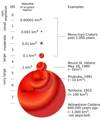
The volcanic explosivity index (VEI) is a relative measure of the explosiveness of volcanic eruptions. It was devised by Christopher G. Newhall of the United States Geological Survey and Stephen Self in 1982.

Hekla, or Hecla, is an active stratovolcano in the south of Iceland with a height of 1,491 m (4,892 ft). Hekla is one of Iceland's most active volcanoes; over 20 eruptions have occurred in and around the volcano since the year 1210. During the Middle Ages, the Icelandic Norse called the volcano the "Gateway to Hell" and the idea spread over much of Europe.

Mount Tambora, or Tomboro, is an active stratovolcano in West Nusa Tenggara, Indonesia. Located on Sumbawa in the Lesser Sunda Islands, it was formed by the active subduction zones beneath it. Before 1815, its elevation reached more than 4,300 metres high, making it one of the tallest peaks in the Indonesian archipelago.

The volcanic winter of AD 536 was the most severe and protracted episode of climatic cooling in the Northern Hemisphere in the last 2,000 years. The volcanic winter was caused by at least three simultaneous eruptions of uncertain origin, with several possible locations proposed in various continents. Most contemporary accounts of the volcanic winter are from authors in Constantinople, the capital of the Eastern Roman Empire, although the impact of the cooler temperatures extended beyond Europe. Modern scholarship has determined that in early AD 536, an eruption ejected massive amounts of sulfate aerosols into the atmosphere, which reduced the solar radiation reaching the Earth's surface and cooled the atmosphere for several years. In March 536, Constantinople began experiencing darkened skies and lower temperatures.

Novarupta is a volcano that was formed in 1912, located on the Alaska Peninsula on a slope of Trident Volcano in Katmai National Park and Preserve, about 290 miles (470 km) southwest of Anchorage. Formed during the largest volcanic eruption of the 20th century, Novarupta released 30 times the volume of magma of the 1980 eruption of Mount St. Helens.

Mount Katmai is a large active stratovolcano on the Alaska Peninsula in southern Alaska, located within Katmai National Park and Preserve. It is about 6.3 miles (10 km) in diameter with a central lake-filled caldera about two by three miles in size, formed during the Novarupta eruption of 1912. The caldera rim reaches a maximum elevation of 6,716 feet (2,047 m). In 1975 the surface of the crater lake was at an elevation of about 4,220 feet (1,286 m), and the estimated elevation of the caldera floor is about 3,400 ft (1,040 m). The mountain is located in Kodiak Island Borough, very close to its border with Lake and Peninsula Borough. The volcano has caused ten known fatalities due to gas exposure.

Santa María Volcano is a large active volcano in the western highlands of Guatemala, in the Quetzaltenango Department near the city of Quetzaltenango. It is part of the mountain range of the Sierra Madre.

The Rabaul caldera, or Rabaul Volcano, is a large volcano on the tip of the Gazelle Peninsula in East New Britain, Papua New Guinea, and derives its name from the town of Rabaul inside the caldera. The caldera has many sub-vents, Tavurvur being the most well known for its devastating eruptions over Rabaul. The outer flanks of the highest peak, a 688-metre-high asymmetrical pyroclastic shield, are formed by thick pyroclastic flow deposits. There is no sign of a pyroclastic shield along the rim of the caldera, making the location likely underwater, on the caldera's floor.

Lake Ilopango is a crater lake which fills an 8 by 11 km volcanic caldera in central El Salvador, on the borders of the San Salvador, La Paz, and Cuscatlán departments. The caldera, which contains the second largest lake in the country and is immediately east of the capital city, San Salvador, has a scalloped 100 m (330 ft) to 500 m (1,600 ft) high rim. Any surplus drains via the Jiboa River to the Pacific Ocean. The local military airbase, Ilopango International Airport, has annual airshows where international pilots from all over the world fly over San Salvador City and Ilopango lake.

Lake Taupō, in the centre of New Zealand's North Island, fills the caldera of the Taupō Volcano, a large rhyolitic supervolcano. This huge volcano has produced two of the world's most powerful eruptions in geologically recent times.

Indonesia is a volcanically active country, containing numerous major volcanoes. It has the most volcanoes of any country in the world, with 76 volcanoes that have erupted at least 1,171 times in total within historical times. The Smithsonian Institution has 141 Indonesian entries in its volcano database. Indonesia has around 130 active volcanoes that are part of the Pacific Ring of Fire, and it has suffered the highest numbers of eruptions resulting in fatalities, damage to arable land, debris flows, tsunamis, lava domes, and pyroclastic flows. Indonesia's most active volcanoes are Kelut and Mount Merapi on the island of Java. The majority of Indonesia's volcano are located on a 3,000 km long chain called the Sunda Arc. Here, the subduction of the Indian Ocean crust underneath the Asian Plate produced most of these volcanoes.

This timeline of volcanism on Earth includes a list of major volcanic eruptions of approximately at least magnitude 6 on the Volcanic explosivity index (VEI) or equivalent sulfur dioxide emission during the Quaternary period. Other volcanic eruptions are also listed.
Mount Tambora is a volcano on the island of Sumbawa in present-day Indonesia, then part of the Dutch East Indies, and its 1815 eruption was the most powerful volcanic eruption in recorded human history. This volcanic explosivity index (VEI) 7 eruption ejected 37–45 km3 of dense-rock equivalent (DRE) material into the atmosphere, and was the most recent confirmed VEI-7 eruption.
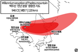
The 946 eruption of Paektu Mountain in Korea and China, also known as the Millennium Eruption or Tianchi eruption, was one of the most powerful volcanic eruptions in recorded history and is classified as a VEI-6 event. The eruption resulted in a brief period of significant climate change in Manchuria. The eruption occurred in late 946 CE.

The Late Antique Little Ice Age (LALIA) was a long-lasting Northern Hemispheric cooling period in the 6th and 7th centuries AD, during the period known as Late Antiquity. The period coincides with three large volcanic eruptions in 535/536, 539/540 and 547. The volcanic winter of 536 was the early phenomenon of the century-long global temperature decline. One study suggested a global cooling of 2 °C (3.6 °F).

Aso caldera is a geographical feature of Kumamoto Prefecture, Japan. It stretches 25 kilometers north to south and 18 kilometers east to west. The central core "Aso Gogaku" is the five major mountains in the area. Aso valley (Asodani) runs along the northern base of Mount Aso and Nango valley (Nangodani) along the south. According to research of caldera sediment, lakes used to exist in these valleys. The dried up lake areas have come to be called Old Aso Lake, Kugino Lake, and Aso Valley Lake. The Kikuchi, Shirakawa and Kurokawa rivers now drain the caldera.

