Tiltmeter

Last updated
A tiltmeter on Mauna Loa, used to predict eruptions by measuring very small changes in the profile of the mountain. Tiltmeter on Mauna Loa.jpg
A tiltmeter on Mauna Loa, used to predict eruptions by measuring very small changes in the profile of the mountain.

A tiltmeter is a sensitive inclinometer designed to measure very small changes from the vertical level, either on the ground or in structures. [1] Tiltmeters are used extensively for monitoring volcanoes, the response of dams to filling, the small movements of potential landslides, the orientation and volume of hydraulic fractures, and the response of structures to various influences such as loading and foundation settlement. Tiltmeters may be purely mechanical or incorporate vibrating-wire or electrolytic sensors for electronic measurement. A sensitive instrument can detect changes of as little as one arc second.

Contents

Tiltmeters have a long history, somewhat parallel to the history of the seismometer. The very first tiltmeter was a long-length stationary pendulum. These were used in the very first large concrete dams, and are still in use today, augmented with newer technology such as laser reflectors. Although they had been used for other applications such as volcano monitoring, they have distinct disadvantages, such as their huge length and sensitivity to air currents. Even in dams, they are slowly being replaced by the modern electronic tiltmeter.

Volcano and Earth movement monitoring then used the water-tube, long baseline tiltmeter. [2] In 1919, the renowned physicist, Albert A. Michelson, noted that the most favorable arrangement to obtain high sensitivity and immunity from temperature perturbations is to use the equipotential surface defined by water in a buried half-filled water pipe. [3] This was a simple arrangement of two water pots, connected by a long water-filled tube. Any change in tilt would be registered by a difference in fill-mark of one pot compared to the other. Although extensively used throughout the world for Earth-science research, they have proven to be quite difficult to operate. For example, due to their high sensitivity to temperature differentials, these always have to be read in the middle of the night.

The modern electronic tiltmeter, which is slowly replacing all other forms of tiltmeter, uses a simple bubble level principle, as used in the common carpenter level. [4] As shown in the figure, an arrangement of electrodes senses the exact position of the bubble in the electrolytic solution, to a high degree of precision. Any small changes in the level are recorded using a standard datalogger. This arrangement is quite insensitive to temperature, and can be fully compensated, using built-in thermal electronics. [5]

A newer technology using microelectromechanical systems (MEMS) sensors enables tilt angle measuring tasks to be performed conveniently in both single and dual axis mode. Ultra-high precision 2-axis MEMS driven digital inclinometer/ tiltmeter instruments are available for speedy angle measurement applications and surface profiling requiring very high resolution and accuracy of one arc second. The 2-axis MEMS driven inclinometers/ tiltmeters can be digitally compensated and precisely calibrated for non-linearity and operating temperature variation, resulting in higher angular accuracy and stability performance over wider angular measurement range and broader operating temperature range. Further, digital display of readings can effectively prevent parallax error as experienced when viewing traditional ‘bubble’ vials located at a distance.

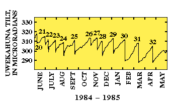
The most dramatic application of tiltmeters is in the area of volcanic eruption prediction. [6] As shown in this figure from the USGS, the main volcano in Hawaii (Kilauea) has a pattern of filling the main chamber with magma, and then discharging to a side vent. The graph shows this pattern of swelling of the main chamber (recorded by the tiltmeter), draining of that chamber, and then an eruption of the adjoining vent. Each number at the peak of tilt, on the graph, is a recorded eruption.

See also

Related Research Articles

<span class="mw-page-title-main">Volcano</span> Rupture in the crust of a planet that allows lava, ash, and gases to escape from below the surface

A volcano is a rupture in the crust of a planetary-mass object, such as Earth, that allows hot lava, volcanic ash, and gases to escape from a magma chamber below the surface.

<span class="mw-page-title-main">Time-domain reflectometer</span> Electronic instrument

A time-domain reflectometer (TDR) is an electronic instrument used to determine the characteristics of electrical lines by observing reflected pulses.

<span class="mw-page-title-main">Mauna Loa</span> Volcano in Hawaii, United States

Mauna Loa is one of five volcanoes that form the Island of Hawaii in the U.S. state of Hawaii in the Pacific Ocean. The largest subaerial volcano in both mass and volume, Mauna Loa has historically been considered the largest volcano on Earth, dwarfed only by Tamu Massif. It is an active shield volcano with relatively gentle slopes, with a volume estimated at 18,000 cubic miles (75,000 km3), although its peak is about 125 feet (38 m) lower than that of its neighbor, Mauna Kea. Lava eruptions from Mauna Loa are silica-poor and very fluid, and tend to be non-explosive.

<span class="mw-page-title-main">Volcanology</span> Study of volcanoes, lava, magma and associated phenomena

Volcanology is the study of volcanoes, lava, magma and related geological, geophysical and geochemical phenomena (volcanism). The term volcanology is derived from the Latin word vulcan. Vulcan was the ancient Roman god of fire.

<span class="mw-page-title-main">Accelerometer</span> Device that measures proper acceleration

An accelerometer is a tool that measures proper acceleration. Proper acceleration is the acceleration of a body in its own instantaneous rest frame; this is different from coordinate acceleration, which is acceleration in a fixed coordinate system. For example, an accelerometer at rest on the surface of the Earth will measure an acceleration due to Earth's gravity, straight upwards of g ≈ 9.81 m/s2. By contrast, accelerometers in free fall will measure zero.

<span class="mw-page-title-main">Kīlauea</span> Active volcano in Hawaii

Kīlauea is an active shield volcano in the Hawaiian Islands. Located along the southeastern shore of Hawai'i Island, the volcano is between 210,000 and 280,000 years old and emerged above sea level about 100,000 years ago. Historically, it is the most active of the five volcanoes that together form the island of Hawaii. Kīlauea is also one of the most active volcanoes on Earth, with the most recent eruption occurring in September 2023 when multiple vents erupted lava for a week within the volcano's summit caldera inside Halemaʻumaʻu crater.

<span class="mw-page-title-main">Spirit level</span> Tool to indicate whether a surface is level or plumb

A spirit level, bubble level, or simply a level, is an instrument designed to indicate whether a surface is horizontal (level) or vertical (plumb). Two basic designs exist: tubular and bull's eye . Different types of spirit levels may be used by carpenters, stonemasons, bricklayers, other building trades workers, surveyors, millwrights and other metalworkers, and in some photographic or videographic work.

<span class="mw-page-title-main">Hawaiian Volcano Observatory</span> Research center in Hawaii, United States

The Hawaiian Volcano Observatory (HVO) is an agency of the U.S. Geological Survey (USGS) and one of five volcano observatories operating under the USGS Volcano Hazards Program. Based in Hilo, Hawaii, the observatory monitors six Hawaiian volcanoes: Kīlauea, Mauna Loa, Kamaʻehuakanaloa, Hualālai, Mauna Kea, and Haleakalā, of which, Kīlauea and Mauna Loa are the most active. The observatory has a worldwide reputation as a leader in the study of active volcanism. Due to the relatively non-explosive nature of Kīlauea's volcanic eruptions for many years, scientists have generally been able to study ongoing eruptions in proximity without being in extreme danger.

<span class="mw-page-title-main">Inclinometer</span> Instrument used to measure the inclination of a surface relative to local gravity

An inclinometer or clinometer is an instrument used for measuring angles of slope, elevation, or depression of an object with respect to gravity's direction. It is also known as a tilt indicator, tilt sensor, tilt meter, slope alert, slope gauge, gradient meter, gradiometer, level gauge, level meter, declinometer, and pitch & roll indicator. Clinometers measure both inclines and declines using three different units of measure: degrees, percentage points, and topos. The astrolabe is an example of an inclinometer that was used for celestial navigation and location of astronomical objects from ancient times to the Renaissance.

<span class="mw-page-title-main">Volcanic gas</span> Gases given off by active volcanoes

Volcanic gases are gases given off by active volcanoes. These include gases trapped in cavities (vesicles) in volcanic rocks, dissolved or dissociated gases in magma and lava, or gases emanating from lava, from volcanic craters or vents. Volcanic gases can also be emitted through groundwater heated by volcanic action.

<span class="mw-page-title-main">Piezoelectric sensor</span> Type of sensor

A piezoelectric sensor is a device that uses the piezoelectric effect to measure changes in pressure, acceleration, temperature, strain, or force by converting them to an electrical charge. The prefix piezo- is Greek for 'press' or 'squeeze'.

<span class="mw-page-title-main">Prediction of volcanic activity</span> Research to predict volcanic activity

Prediction of volcanic activity, or volcanic eruption forecasting, is an interdisciplinary monitoring and research effort to predict the time and severity of a volcano's eruption. Of particular importance is the prediction of hazardous eruptions that could lead to catastrophic loss of life, property, and disruption of human activities.

<span class="mw-page-title-main">Kīlauea Iki</span> Volcano crater

<span class="mw-page-title-main">Halemaʻumaʻu</span> Pit crater located within the summit caldera of Kīlauea in Hawaii

Halemaʻumaʻu is a pit crater within the much larger Kīlauea Caldera at the summit of Kīlauea volcano on island of Hawaiʻi. The roughly circular crater was 770 meters (2,530 ft) x 900 m (2,950 ft) before collapses that roughly doubled the size of the crater after May 3, 2018. Following the collapses of 2018, the bottom of Halemaʻumaʻu was roughly 600 m (2,000 ft) below the caldera floor. Halemaʻumaʻu is home to Pele, goddess of fire and volcanoes, according to the traditions of Hawaiian religion. Halemaʻumaʻu means "house of the ʻāmaʻu fern".

<span class="mw-page-title-main">Lava</span> Molten rock expelled by a volcano during an eruption

Lava is molten or partially molten rock (magma) that has been expelled from the interior of a terrestrial planet or a moon onto its surface. Lava may be erupted at a volcano or through a fracture in the crust, on land or underwater, usually at temperatures from 800 to 1,200 °C. The volcanic rock resulting from subsequent cooling is also often called lava.

<span class="mw-page-title-main">2018 lower Puna eruption</span> Volcanic eruption on Hawaiʻi Island

The 2018 lower Puna eruption was a volcanic event on the island of Hawaiʻi, on Kīlauea volcano's East Rift Zone that began on May 3, 2018. It is related to the larger eruption of Kīlauea that began on January 3, 1983, though some volcanologists and USGS scientists have discussed whether to classify it as a new eruption. Outbreaks of lava fountains up to 300 feet (90 m) high, lava flows, and volcanic gas in the Leilani Estates subdivision were preceded by earthquakes and ground deformation that created cracks in the roads.

<span class="mw-page-title-main">Deformation (volcanology)</span> Change in the shape of a volcano or the land surrounding it

In volcanology, deformation is any change in the shape of a volcano or the land surrounding it. This can be in the form of inflation, which is a response to pressurization, or deflation, which is a response to depressurization. Inflation is represented by swelling of the ground surface, a volcanic edifice, or a subsurface magma body. It can be caused by magma accumulation, exsolution of volatiles, geothermal processes, heating, and tectonic compression. Deflation is represented by shrinking of the ground surface, a volcanic edifice, or a subsurface magma body. It can be caused by magma withdrawal, volatile escape, thermal contraction, phase changes during crystallization, and tectonic extension. Deformation is a key indicator of pre-eruptive unrest at many active volcanoes. The term bradyseism is used in the volcanological literature to mean the vertical ground movements associated with the Phlegraean Fields volcanic area west of Naples, Italy.

<span class="mw-page-title-main">Tilt detector</span>

A tilt detector or tilt indicator is a device which indicates whether a tilt has occurred. Tilt detectors can be used on shipments of tilt sensible items to indicate whether a potentially damaging tilt have occurred. They are also used in the field of electronics or automotive on some models to detect if a change in vehicle inclination has occurred.

<span class="mw-page-title-main">2022 eruption of Mauna Loa</span> 2022 volcano eruption in Hawaiʻi

The 2022 eruption of Mauna Loa was an episode of eruptive volcanic activity at Mauna Loa, the world's largest active volcano, located on Hawaiʻi island, Hawaiʻi. Mauna Loa began to erupt shortly before midnight HST on November 27, 2022, when lava flows emerged from fissure vents in Moku‘āweoweo. It marked the first eruption at the volcano in 38 years. The eruption ended on December 13, 2022, after more than two weeks.

References

  1. John Dunnicliff Geotechnical instrumentation for monitoring field performance Wiley-IEEE, 1993 ISBN   0-471-00546-0, pp. 216–219
  2. "How We Monitor Volcanoes". Volcanoes.usgs.gov. 2008-08-13. Retrieved 2014-05-30.
  3. "What is a Tiltmeter?". www.wisegeek.com. 2014-05-30. Retrieved 2014-05-30.
  4. "Tiltmeter Basics". www.geomechanics.com. Archived from the original on August 25, 2006.
  5. "Movement on the Surface Provides Information About the Subsurface | U.S. Geological Survey".
  6. "How We Monitor Volcanoes". Volcanoes.usgs.gov. 2008-08-13. Retrieved 2014-02-05.