4th century CE
| | This section is empty. You can help by adding to it. (July 2010) |
A timeline of Chacoan history includes Chaco Culture National Historical Park, Aztec Ruins National Monument, Twin Angels Pueblo, Casamero Pueblo, Kin Nizhoni, Pierre's Site, and Halfway House.
| | This section is empty. You can help by adding to it. (July 2010) |
| | This section is empty. You can help by adding to it. (July 2010) |
| | This section is empty. You can help by adding to it. (July 2010) |
| | This section is empty. You can help by adding to it. (July 2010) |
| | This section is empty. You can help by adding to it. (July 2010) |
| | This section is empty. You can help by adding to it. (July 2010) |

Chaco Culture National Historical Park is a United States National Historical Park in the American Southwest hosting a concentration of pueblos. The park is located in northwestern New Mexico, between Albuquerque and Farmington, in a remote canyon cut by the Chaco Wash. Containing the most sweeping collection of ancient ruins north of Mexico, the park preserves one of the most important pre-Columbian cultural and historical areas in the United States.

Hovenweep National Monument is located on land in southwestern Colorado and southeastern Utah, between Cortez, Colorado and Blanding, Utah on the Cajon Mesa of the Great Sage Plain. Shallow tributaries run through the wide and deep canyons into the San Juan River.

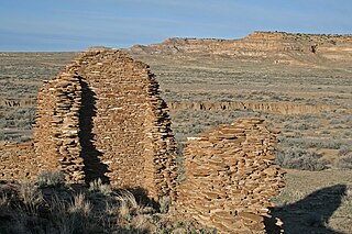
Pueblo Bonito is the largest and best-known great house in Chaco Culture National Historical Park, northern New Mexico. It was built by the Ancestral Puebloans who occupied the structure between AD 828 and 1126.

Richard Wetherill (1858–1910), a member of a Colorado ranching family, was an amateur archaeologist who discovered, researched and excavated sites associated with the Ancient Pueblo People. He is credited with the rediscovery of Cliff Palace in Mesa Verde in Colorado and was responsible for initially selecting the term Anasazi, Navajo for ancient enemies, as the name for these ancient people. He also excavated Kiet Seel ruin, now in Navajo National Monument in northeastern Arizona, and Pueblo Bonito in Chaco Canyon, New Mexico.
This is a timeline of in North American prehistory, from 1000 BC until European contact.

Salmon Ruins is an ancient Chacoan and Pueblo site located in the northwest corner of New Mexico, USA. Salmon was constructed by migrants from Chaco Canyon around 1090 CE, with 275 to 300 original rooms spread across three stories, an elevated tower kiva in its central portion, and a great kiva in its plaza. Subsequent use by local Middle San Juan people resulted in extensive modifications to the original building, with the reuse of hundreds of rooms, division of many of the original large, Chacoan rooms into smaller rooms, and emplacement of more than 20 small kivas into pueblo rooms and plaza areas. The site was occupied by ancient Ancestral Puebloans until the 1280s, when much of the site was destroyed by fire and abandoned. The pueblo is situated on the north bank of the San Juan River, just to the west of the modern town of Bloomfield, New Mexico, and about 45 miles (72 km) north of Pueblo Bonito in Chaco Canyon. The site was built on the first alluvial terrace above the San Juan River floodplain.
Una Vida is an archaeological site located in Chaco Canyon, San Juan County, New Mexico, United States. According to tree rings surrounding the site, its construction began around 800 AD, at the same time as Pueblo Bonito, and it is one of the three earliest Chacoan Ancestral Puebloan great houses. Comprising at least two stories and 160 rooms, it shares an arc or D-shaped design with its contemporaries, Peñasco Blanco and Pueblo Bonito, but has a unique "dog leg" addition made necessary by topography. It is located in one of the canyon's major side drainages, near Gallo Wash, and was massively expanded after 930 AD.

Kin Kletso is a Chacoan Ancestral Pueblo great house and notable archaeological site located in Chaco Culture National Historical Park, 25 miles (40 km) southwest of Nageezi, New Mexico, United States. It was a medium-sized great house located 0.5 miles (0.8 km) west of Pueblo Bonito; it shows strong evidence of construction and occupation by Pueblo peoples who migrated to Chaco from the northern San Juan Basin in the time period of 1125 to 1200. From its masonry work, rectangular shape and design Kletso is identified as Pueblo III architecture by prominent Chaco archaeologists Stephen H. Lekson and Tom Windes. They also argue that this great house was only occupied by one or two households. Fagen writes that Kletso contained around 55 rooms, four ground-floor kivas, and a two-story cylindrical tower that may have functioned as a kiva or religious center. Evidence of an obsidian production industry were discovered here. The house was erected between 1125 and 1130.

Chetro Ketl is an Ancestral Puebloan great house and archeological site located in Chaco Culture National Historical Park, New Mexico, United States. Construction on Chetro Ketl began c. 990 and was largely complete by 1075, with significant remodeling occurring in the early and mid-1110s. Following the onset of a severe drought, most Chacoans emigrated from the canyon by 1140; by 1250 Chetro Ketl's last inhabitants had vacated the structure.
Kin Nahasbas is a Chacoan Anasazi great house and archaeological site located in Chaco Canyon, 25 miles southwest of Nageezi, New Mexico, United States. Built in either the 9th or 10th centuries, it was major pueblo located slightly north of the Una Vida complex, which is positioned at the foot of the north mesa. Limited excavation has been conducted in this area. The ruins are now protected within the borders of Chaco Culture National Historical Park.

Peñasco Blanco is a Chacoan Ancestral Puebloan great house and notable archaeological site located in Chaco Canyon, a canyon in San Juan County, New Mexico, United States. The pueblo consists of an arc-shaped room block, part of an oval enclosing a plaza and great kiva, along with two great kivas outside the great house. The pueblo was built atop the canyon's southern rim to the northwest of the great houses in the main section of the canyon.

The Canyons of the Ancients Visitor Center and Museum located in Dolores, Colorado, is an archaeological museum of Native American pueblo and hunter-gatherer cultures. Two 12th-century archaeological sites, the Escalante and Dominguez Pueblos, at the center were once home to Ancient Pueblo peoples. The museum's permanent and special exhibits display some of the 3 million mostly Ancestral Puebloan artifacts curated at the facility. The center also houses a public research library, educational resources and a museum shop. Wheelchair-accessible facilities include a picnic area and an interpreted nature and cultural trail.

Hundreds of Ancestral Puebloan dwellings are found across the American Southwest. With almost all constructed well before 1492 CE, these Puebloan towns and villages are located throughout the geography of the Southwest.

The Ansel Hall Ruin, also known as Cahone Ruin, is located in Cahone, Dolores County, Colorado. A pre-historic ruins from the Pueblo II period, the Northern San Juan pueblo was added to the National Register of Historic Places in 1997.

The Ancestral Puebloans, also known as the Anasazi, were an ancient Native American culture that spanned the present-day Four Corners region of the United States, comprising southeastern Utah, northeastern Arizona, northwestern New Mexico, and southwestern Colorado. They are believed to have developed, at least in part, from the Oshara tradition, which developed from the Picosa culture. The people and their archaeological culture are often referred to as Anasazi, meaning "ancient enemies", as they were called by Navajo. Contemporary Puebloans object to the use of this term, with some viewing it as derogatory.

Bonito Phase is an archeological term that refers to the period between 900 and 1140 CE, during which the Ancestral Puebloans in the Chaco Canyon area constructed numerous great houses. The system is divided into three parts: the Early Bonito phase from 900 to 1040; the Classic Bonito phase from 1040 to 1100, and the Late Bonito phase from 1100 to 1140. When the system was created in the 1980s, it was thought that construction at Pueblo Bonito began around 920, but it is now known that building at the great house started almost one hundred years earlier, c. 850.

Guadalupe Outlier is an Ancestral Puebloan site in Chaco Culture National Historical Park, in New Mexico, United States. The site is described by author Stephen H. Lekson as "sitting atop the second-most spectacular setting of any outlier, a narrow high mesa overlooking the Rio Puerco, about 100 kilometres (62 mi) from Chaco". Guadalupe Outlier is the easternmost of the Chacoan ruins and was occupied from roughly 920 to 1130 AD. By the late thirteenth century it had been "remodeled and occupied by a Mesa Verde population". The site was excavated by Lonnie C. Pippin between 1972 and 1975 as part of Eastern New Mexico University's Rio Puerco Valley Archaeological Project. The evidence from Guadalupe Ruin reveals some of these Chaco outliers were established only shortly after the initial development of the Great Pueblos in Chaco Canyon. Throughout their histories, these Chaco outliers were closely related to organized developments in Chaco Canyon and were tied to the Great Houses in the canyon by a network of roads. Nevertheless, despite the architectural similarities and networks of communication between Chaco outliers and the Great Pueblos in Chaco Canyon, the occupants of outlying Chaco towns such as Guadalupe Ruin had a material culture like that of the regionally differentiated village populations.

McElmo Phase refers to a period in the late 11th and early 12th centuries, when drastic changes in ceramics and masonry techniques in Chaco Canyon appeared. During this period the Ancestral Puebloans living in the canyon started using painted black-on-white pottery versus their standard grey ware, and the masonry and layout of great houses built during the McElmo phase, which was the last major construction era in the canyon, differ significantly from those built during the early parts of the Bonito Phase, which overlaps with the McElmo Phase. Archeologists initially suggested that the McElmo influence was brought to Chaco Canyon by immigrants from Mesa Verde, but subsequent research suggests that the developments were of local origin. Archeologist R. Gwinn Vivian notes, "The jury is still out on this question, a problem that poses intriguing possibilities for future work."

The Jackson Staircase is a pair of Ancestral Puebloan steps cut into the cliff of Chaco Canyon, New Mexico. Located north of Chetro Ketl and east of Pueblo Alto, the stairs gave Chacoans access to the Great North Road. The feature is named after William Henry Jackson, who discovered the stairs in 1877.
The Roads of Chaco stretch all over the Chaco Canyon. These roads have many theorized uses ranging from economic, military, and a total unification effort of the canyon as a whole.