
Tiputini Biodiversity Station (TBS) is a scientific field research center in the Ecuadorian Amazon. It was established in 1995 by Universidad San Francisco de Quito in collaboration with Boston University, and is jointly managed by them as a center of education, research and conservation. A higher diversity of reptiles, amphibians, insects, birds and bats has been found there than anywhere else in South America, and possibly the world. It is located in the province of Orellana, about 280 km ESE from Quito, the capital city of Ecuador. It is located on the northern bank of the Tiputini River, and although separated from the Yasuní National Park by the river, the station forms part of the Yasuní Biosphere Reserve.
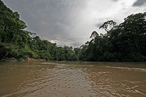
The Tiputini River is a tributary of the Napo River in eastern Ecuador. It is the first major, navagable river south of the Napo and forms the northern border of Yasuni National Park. Unlike the Napo, the Tiputini has a relatively deep, narrow channel carved deep into the clay of the Amazon Basin, and it often fluctuates in depth by several meters from day to day.
Edmundo Carvajal Airport (Spanish: Aeropuerto "Coronel Edmundo Carvajal", also known as Macas Airport, is an airport serving Macas, the capital of Morona-Santiago Province in Ecuador. The airport is named for Edmundo Carvajal Flores, a former commander of the Ecuadorian Air Force.

Río Amazonas Airport is an airport serving Shell Mera, a town in the Pastaza Province of Ecuador. The airport was established in 1937 by Royal Dutch Shell and abandoned in 1948. In 1949 the Mission Aviation Fellowship, a Christian missionary group, established themselves in the area and used the airport as their main base.

San Cristóbal Airport is an airport on the island of San Cristóbal, in the Galápagos Islands of Ecuador. The airport is on the southwestern end of the island, with rising terrain to the northeast. Approaches to both runways are over the ocean.
Chachoan Airport is a high elevation airport serving Ambato, capital of the Tungurahua Province in Ecuador. The airport is 6 kilometres (3.7 mi) northeast of Ambato, in a broad basin of the central Andes mountains cut through by the Ambato River.
José María Velasco Ibarra Airport is an airport serving Macará, a city in the Loja Province of Ecuador. Macará is on Ecuador's border with Peru.
Tarapoa Airport is an airport serving Tarapoa, a town in the Sucumbíos Province of Ecuador.

Aguarico Canton is a canton of Ecuador, located in the Orellana Province. Its capital is the town of Nuevo Rocafuerte. Its population at the 2010 census was 4,658 INEC 2010.
Los Perales Airport is an airport serving the city of Bahía de Caráquez in Manabí Province, Ecuador. The airport is across the Chone River from the city and is reached via a 1.7 kilometres (1 mi) causeway.
Gualaquiza Airport is an airport serving the town of Gualaquiza in Morona-Santiago Province, Ecuador. The airport is at the entrance to a mountain valley, with nearby rising and high terrain west through north through east. The southern quadrants are open.
Atahualpa Airport was an airport formerly serving the town of Ibarra in Imbabura Province, Ecuador.
El Carmen Airport is an airport serving the Bobonaza River village of Montalvo in Pastaza Province, Ecuador. The runway is within a bend of the river, and approaches to either end will cross the water.
Putumayo Airport is an airport serving the Putumayo River village of Puerto El Carmen de Putumayo in Sucumbíos Province, Ecuador. The runway is in a bend of the river 1 kilometre (0.6 mi) east of the village.
Chimborazo Airport is an airport serving the city of Riobamba in Chimborazo Province, Ecuador.
Santa Cecilia Airport is an airport serving the village of Santa Cecilia in Sucumbíos Province, Ecuador.
Sucúa Airport is an airport serving the town of Sucúa in Morona-Santiago Province, Ecuador.
Taisha Airport is an airport serving the town of Taisha in Morona-Santiago Province, Ecuador.
Taura Air Base is a military airport 24 kilometres (15 mi) east of Guayaquil in Guayas Province, Ecuador. The base is on the west bank of the Taura River.
