Related Research Articles

Legio II Augusta was a legion of the Imperial Roman army that was founded during the late Roman republic. Its emblems were the Capricornus, Pegasus, and Mars. It may have taken the name "Augusta" from a victory or reorganization that occurred during the reign of Augustus.
Legio IX Hispana, also written Legio VIIII Hispana, was a legion of the Imperial Roman army that existed from the 1st century BC until at least 120 AD. The legion fought in various provinces of the late Roman Republic and early Roman Empire. The nickname "Hispana" was gained when it was stationed in Hispania under Augustus. It was stationed in Britain following the Roman invasion in 43 AD. The legion disappears from surviving Roman records after c. 120 AD and there is no extant account of what happened to it.

Roman roads in Britannia were initially designed for military use, created by the Roman army during the nearly four centuries (AD 43–410) that Britannia was a province of the Roman Empire.

The Antonine Plague of AD 165 to 180, also known as the Plague of Galen, was the first known pandemic impacting the Roman Empire, possibly contracted and spread by soldiers who were returning from campaign in the Near East. Scholars generally believe the plague was smallpox, although measles has also been suggested, and recent genetic evidence strongly suggests that smallpox only arose much later. In AD 169 the plague may have claimed the life of the Roman emperor Lucius Verus, who was co-regnant with Marcus Aurelius. These two emperors had risen to the throne by virtue of being adopted by the previous emperor, Antoninus Pius, and as a result, their family name, Antoninus, has become associated with the pandemic.

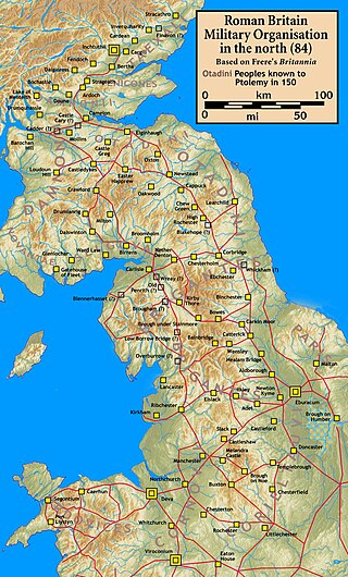
The Gask Ridge is the modern name given to an early series of fortifications, built by the Romans in Scotland, close to the Highland Line. Modern excavation and interpretation has been pioneered by the Roman Gask Project, with Birgitta Hoffmann and David Woolliscroft. The ridge fortifications: forts, fortlets and watchtowers were only in operation for a few years, probably less than ten.
The Selgovae were a Celtic tribe of the late 2nd century AD who lived in what is now the Stewartry of Kirkcudbright and Dumfriesshire, on the southern coast of Scotland. They are mentioned briefly in Ptolemy's Geography, and there is no other historical record of them. Their cultural and ethnic affinity is commonly assumed to have been Brittonic.

Britannia Superior was a province of Roman Britain created after the civil war between Septimius Severus and Claudius Albinus. Although Herodian credits Severus with dividing Roman Britain into the Northern territory of Britannia Inferior and the Southern territory of Britannia Superior, modern scholarship argues that it is more likely that Caracella was the person who made the split sometime in the early 3rd century CE. The previous British capital Londinium remained the centre of Britannia Superior while Eboracum, or modern York was the capital of Britannia Inferior. Epigraphical evidence shows that Upper Britain encompassed approximately what is now Wales, southern England and East Anglia. However, the official boundary between Britannia Superior and Inferior is still unclear.

Quintus Lollius Urbicus was a Numidian Berber governor of Roman Britain between the years 139 and 142, during the reign of the Emperor Antoninus Pius. He is named in the Historia Augusta, although it is not entirely historical, and his name appears on five Roman inscriptions from Britain; his career is set out in detail on a pair of inscriptions set up in his native Tiddis near Cirta, Numidia.
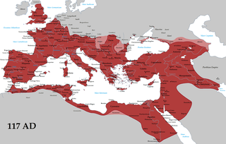
The borders of the Roman Empire, which fluctuated throughout the empire's history, were realised as a combination of military roads and linked forts, natural frontiers and man-made fortifications which separated the lands of the empire from the countries beyond.

Westerwood is an area in the north-east of Cumbernauld in North Lanarkshire, Scotland. Historically it was the site of a Roman Fort of which a video reconstruction has been produced. In the past two decades, new housing developments have been built around the Westerwood Hotel and Golf Course. The golf course, which was designed by Seve Ballesteros and Dave Thomas, is located on the north side of the town, close to Cumbernauld Airport. Westerwood Community Council was set up for local residents and a committee has been appointed. Neighbouring villages which are outside of Cumbernauld include Dullatur to the north-west and Castlecary to the east.

The Antonine Wall, known to the Romans as Vallum Antonini, was a turf fortification on stone foundations, built by the Romans across what is now the Central Belt of Scotland, between the Firth of Clyde and the Firth of Forth. Built some twenty years after Hadrian's Wall to the south, and intended to supersede it, while it was garrisoned it was the northernmost frontier barrier of the Roman Empire. It spanned approximately 63 kilometres and was about 3 metres high and 5 metres wide. Lidar scans have been carried out to establish the length of the wall and the Roman distance units used. Security was bolstered by a deep ditch on the northern side. It is thought that there was a wooden palisade on top of the turf. The barrier was the second of two "great walls" created by the Romans in Great Britain in the second century AD. Its ruins are less evident than those of the better-known and longer Hadrian's Wall to the south, primarily because the turf and wood wall has largely weathered away, unlike its stone-built southern predecessor.

Arthur's O'on was a stone building thought to be Roman temple that, until 1743, stood on rising ground above the north bank of the River Carron not far from the old Carron ironworks in Stenhousemuir, near Falkirk, Scotland. The structure is thought to be the 'stone house' which gave its name to Stenhousemuir. Early historians discussed historical and mythical associations with the site and by 1200 the estate of Stenhouse on which it stood had been named after it.
Blatobulgium was a Roman fort, located at the modern-day site known as Birrens, in Dumfriesshire, Scotland.

Bothwellhaugh Roman Fort is a site now located within Strathclyde Country Park in North Lanarkshire, Scotland. It is east of where the South Calder Water flows into Strathclyde Loch. The fort is a scheduled monument.
The Hadrianic Society was a British historical society focused upon Hadrian's Wall and Roman Britain as well as the Antonine Wall, the Gask Ridge, and other Roman Frontier systems. It was founded in 1971 under the leadership of Brian Dobson, David Breeze, and Valerie Maxfield. The Hadrianic Society closed in 2018. Some of its functions continue to be fulfilled by the Roman Army School.
Durno or Logie Durno, located 6 miles (9.7 km) north west of Inverurie in Aberdeenshire, Scotland, is the site of a Roman marching camp, first discovered by aerial photography in July 1975 and excavated in 1976 and 1977.

The frontier of the Roman Empire in Britain is sometimes styled Limes Britannicus by authors for the boundaries, including fortifications and defensive ramparts, that were built to protect Roman Britain. These defences existed from the 1st to the 5th centuries AD and ran through the territory of present-day England, Scotland and Wales.
Anne Strachan Robertson FSA FSAScot FRSE FMA FRNS was a Scottish archaeologist, numismatist and writer, who was Professor of Roman Archaeology at the University of Glasgow and Keeper of the Cultural Collections and of the Hunterian Coin Cabinet at the Hunterian Museum. She was recognised by her research regarding Roman Imperial coins and as "a living link with the pioneers of archaeological research".


Bar Hill Fort was a Roman fort on the Antonine Wall in Scotland. It was built around the year 142 A.D.. Older maps and documents sometimes spell the name as Barr Hill. A computer generated fly around for the site has been produced. Lidar scans have been done along the length of the wall including Bar Hill. Sir George Macdonald wrote about the excavation of the site. Many other artefacts have also been found at Shirva, about a mile away on the other side of Twechar.
References
- ↑ Henderson, A., & Keppie, L. (1987). Titulus or Titulum? Britannia, 18, 281-284. doi:10.2307/526456 https://www.cambridge.org/core/journals/britannia/article/titulus-or-titulum/13A9CBB2B58D94A2249150F1838466C9#
- ↑ Frere, S.S., and St Joseph, J.K.S. 1983: Roman Britain from the Air, Cambridge
- ↑ Henderson, A., & Keppie, L. (1987). Titulus or Titulum? Britannia, 18, 281-284. doi:10.2307/526456 https://www.cambridge.org/core/journals/britannia/article/titulus-or-titulum/13A9CBB2B58D94A2249150F1838466C9#, referring to Schulten, A., Numantia: die Ergebnisse der Ausgrabungen 1905–1919 (München, 1914–1931) Band IV. pl. 1: Keppie, L., The Making of the Roman Army (London, 1984), fig. 12.
- ↑ John H. Reid and Andrew Nicholson (2019). "Burnswark Hill: the opening shot of the Antonine reconquest of Scotland?" (PDF). Journal of Roman Archaeology. p. 476-477.
- ↑ "titulum". Oxford Reference.
| | This United Kingdom military article is a stub. You can help Wikipedia by expanding it. |