
A chambered cairn is a burial monument, usually constructed during the Neolithic, consisting of a sizeable chamber around and over which a cairn of stones was constructed. Some chambered cairns are also passage-graves. They are found throughout Britain and Ireland, with the largest number in Scotland.

Orkney, also known as the Orkney Islands or The Orkneys, is an archipelago in the Northern Isles of Scotland, situated off the north coast of the island of Great Britain. Orkney is 10 miles (16 km) north of the coast of Caithness and has about 70 islands, of which 20 are inhabited. The largest island, the Mainland, has an area of 523 square kilometres (202 sq mi), making it the sixth-largest Scottish island and the tenth-largest island in the British Isles. Orkney's largest settlement, and also its administrative centre, is Kirkwall.

The Ring of Brodgar is a Neolithic henge and stone circle about 6 miles north-east of Stromness on Mainland, the largest island in Orkney, Scotland. It is part of the UNESCO World Heritage Site known as the Heart of Neolithic Orkney.

There are three related types of Neolithic earthwork that are all sometimes loosely called henges. The essential characteristic of all three is that they feature a ring-shaped bank and ditch, with the ditch inside the bank. Because the internal ditches would have served defensive purposes poorly, henges are not considered to have been defensive constructions. The three henge types are as follows, with the figure in brackets being the approximate diameter of the central flat area:
- Henge. The word henge refers to a particular type of earthwork of the Neolithic period, typically consisting of a roughly circular or oval-shaped bank with an internal ditch surrounding a central flat area of more than 20 m (66 ft) in diameter. There is typically little if any evidence of occupation in a henge, although they may contain ritual structures such as stone circles, timber circles and coves. Henge monument is sometimes used as a synonym for henge. Henges sometimes, but by no means always, featured stone or timber circles, and circle henge is sometimes used to describe these structures. The three largest stone circles in Britain are each within a henge. Examples of henges without significant internal monuments are the three henges of Thornborough Henges. Although having given its name to the word henge, Stonehenge is atypical in that the ditch is outside the main earthwork bank.
- Hengiform monument. Like an ordinary henge, except the central flat area is between 5 and 20 m (16–66 ft) in diameter, they comprise a modest earthwork with a fairly wide outer bank. The terms Mini henge or Dorchester henge are sometimes used as synonyms for hengiform monument. An example is the Neolithic site at Wormy Hillock Henge.
- Henge enclosure. A Neolithic ring earthwork with the ditch inside the bank, with the central flat area having abundant evidence of occupation and usually being more than 300 m (980 ft) in diameter. Some true henges are as large as this, but lack evidence of domestic occupation. Super henge is sometimes used as a synonym for a henge enclosure. However, sometimes Super henge is used to indicate size alone rather than use, e.g. "Marden henge ... is the least understood of the four British 'superhenges' ".

Sanday is one of the inhabited islands of Orkney that lies off the north coast of mainland Scotland. With an area of 50.43 km2 (19.5 sq mi), it is the third largest of the Orkney Islands. The main centres of population are Lady Village and Kettletoft. Sanday can be reached by Orkney Ferries or by plane from Kirkwall on the Orkney Mainland. On Sanday, an on-demand public minibus service allows connecting to the ferry.

The court cairn or court tomb is a megalithic type of chambered cairn or gallery grave. During the period, 3900–3500 BC, more than 390 court cairns were built in Ireland and over 100 in southwest Scotland. The Neolithic monuments are identified by an uncovered courtyard connected to one or more roofed and partitioned burial chambers. Many monuments were built in multiple phases in both Ireland and Scotland and later re-used in the Early Bronze Age.

Unstan ware is the name used by archaeologists for a type of finely made and decorated Neolithic pottery from the 4th and 3rd millennia BC. Typical are elegant and distinctive shallow bowls with a band of grooved patterning below the rim, a type of decoration which was created using a technique known as "stab-and-drag". A second version consists of undecorated, round-bottomed bowls. Some of the bowls had bits of volcanic rock included in the clay to make them stronger. Bone tools were used to burnish the surfaces to make them shiny and impermeable.

The Neolithic Barnhouse Settlement is sited by the shore of Loch of Harray, Orkney Mainland, Scotland, not far from the Standing Stones of Stenness, about 5 miles north-east of Stromness.

Skigersta is a village to the south east of Ness on the Isle of Lewis, in the Outer Hebrides, Scotland. It is the easternmost settlement in the Ness district and is 5km (3miles) southeast of the Butt of Lewis. Skigersta is situated within the parish of Barvas. There is a quay built in 1901 and a shingle beach. The area of Skigersta near the shore is called 'Lachamore'. To the south of Skigersta the moor begins and the road turns into a peat track; there are sheilings on the moor at Cuisiadar and if you follow the moor further south you reach the road at New Tolsta.

Prehistoric Orkney refers only to the prehistory of the Orkney archipelago of Scotland that begins with human occupation. Although some records referring to Orkney survive that were written during the Roman invasions of Scotland, “prehistory” in northern Scotland is defined as lasting until the start of Scotland's Early Historic Period.

Links of Noltland is a large prehistoric settlement located on the north coast of the island of Westray in Orkney, Scotland. The extensive ruins includes several late Neolithic and early Bronze Age dwellings and is place of discovery of the Westray Wife figurine, first uncovered during an excavation in 2009. Historic Environment Scotland established the site as a scheduled monument in 1993.
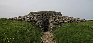
Quoyness chambered cairn is a Neolithic burial monument located on the island of Sanday in Orkney, Scotland. Similar to Maeshowe in design, the tomb was probably built around 3000 BC. The skeletal remains of several people were uncovered in the tomb during excavation in 1867. The monument was partially restored and reconstructed after a second excavation during the early 1950s, to display the different original stages of construction of the tomb. The property is now in the care of Historic Environment Scotland as a scheduled monument.

The architecture of Scotland in the prehistoric era includes all human building within the modern borders of Scotland, before the arrival of the Romans in Britain in the first century BCE. Stone Age settlers began to build in wood in what is now Scotland from at least 8,000 years ago. The first permanent houses of stone were constructed around 6,000 years ago, as at Knap of Howar, Orkney and settlements like Skara Brae. There are also large numbers of chambered tombs and cairns from this era, particularly in the west and north. In the south and east there are earthen barrows, often linked to timber monuments of which only remnants remain. Related structures include bank barrows, cursus monuments, mortuary enclosures and timber halls. From the Bronze Age there are fewer new buildings, but there is evidence of crannogs, roundhouses built on artificial islands and of Clava cairns and the first hillforts. From the Iron Age there is evidence of substantial stone Atlantic roundhouses, which include broch towers, smaller duns. There is also evidence of about 1,000 hillforts in Scotland, most located below the Clyde-Forth line.
The Northern European Enclosure Dam (NEED) is a proposed solution to the problem of rising ocean levels in Northern Europe. It would be a megaproject, involving the construction of two massive dams in the English Channel and the North Sea; the former between France and England, and the latter between Scotland and Norway. The concept was conceived by the oceanographers Sjoerd Groeskamp and Joakim Kjellsson.

The Knowes of Trotty is a Bronze Age cemetery located in Mainland, Orkney in Scotland. The ancient site consists of a group of twelve surviving burial mounds, dating to 2030–1770 BC. Along with cremated human remains, four gold discs and a number of amber beads and pendants were discovered in the largest mound in 1858. Knowes of Trotty is one of the earliest group of burial mounds in Orkney and one of the largest Bronze Age cemeteries in the United Kingdom.

The Stone of Setter is a Neolithic standing stone located on the island of Eday, in Orkney, Scotland. It dates to the Late Neolithic or Early Bronze Age, around the 2nd millennium BC. Outside of the Stones of Stenness, this monument is the tallest monolith in Orkney. Historic Environment Scotland established the site as a scheduled monument in 1936.

Quanterness chambered cairn is a Neolithic burial monument located on Mainland, Orkney in Scotland. An Iron Age roundhouse built into the cairn was discovered during excavation in the early 1970s. The dwelling was constructed around 700 BC. Also found during excavation, were the remains of 157 people, pottery remnants and other artefacts. Historic Environment Scotland established the site as a scheduled monument in 1929.

Kettla Ness is a tied island and headland in Shetland. It is connected by the tombolo Minn beach, to the south end of West Burra, part of the Scalloway Islands. The headland itself is conspicuous and circa 160 feet high. The island is accessible to walkers via Minn beach and is now uninhabitated. It is principally used for Sheep farming and pasture.

