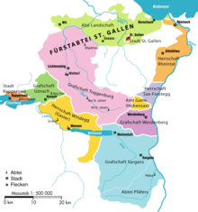
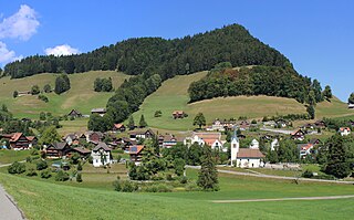
View of the Thur and the church of Stein, facing north, with the Churfirsten visible in the backdrop.Streusiedlung at the eastern end of the ToggenburgMap of the historical territories of the Canton of St. Gallen. The former county of Toggenburg is shown in pink.The Churfirsten (view from Alpstein with Toggenburg below)
Toggenburg is a region of Switzerland. It corresponds to the upper valley of the river Thur[1] and that of its main tributary, the Necker. Since 1 January 2003, Toggenburg has been a constituency (Wahlkreis) of the canton of St. Gallen (SFOS number 1727).
The valley descends in a northwestern direction from the watershed between the Rhine and the Thur, and is enclosed on the northeast by the chain of the Säntis (8,216ft [2,504m]) and on the southwest by that of the Churfirsten (7,566ft [2,306m]) and of the Speer (6,411ft [1,954m]). It is a fertile valley of about 45 kilometres (28mi) in length from the source of the river to Wil.[1]
The upper Thur valley was part of the province of Raetia in the Roman era, and was reached by Alemannic-speaking settlers only in the early medieval period. This is evidenced by a substantial substrate of Romance toponyms in the upper Toggenburg (upstream of Stein).[2]
The name of the region is derived from that of the House of Toggenburg (named for their castle near Kirchberg) who ruled over parts of the Toggenburg region since the 12th century, in the 13th century taking the title of counts (comes) and extending their domain to include all of the upper Thur valley. The extinction of the main line of the counts of Toggenburg (1436)[1] led to the Old Zürich War (1440–46) ultimately resulting in the temporary expulsion of Zürich from the Swiss confederacy. Eventually, the Toggenburg passed to the lord of Raron (in Valais), who sold it to the abbot of St. Gall in 1468.[1]
Part of the Toggenburg followed the Swiss Reformation led by Zwingli, and the valley declared itself independent in 1530, but was forced to re-submit to the Abbot of St. Gall in 1538. The Abbot was, however, pressured into toleration of either confession, so that the Toggenburg became one of the few regions of Switzerland where Catholicism and Protestantism have a tradition of co-existence.
In 1707, the Toggenburg again declared its independence of St. Gall, in reaction to the Abbey's plans to build a road across the Ricken Pass, which was seen as a strategic arrangement towards a Catholic military alliance. The ensuing Toggenburg war of 1712 resulted in a balance of power between Catholic and Protestant cantons, ultimately leading to the formation of Switzerland as a federal state.
The Toggenburg Wahlkreis has a population of 46,954 (as of 31 December 2020).[3] Of the foreign population, (as of 2000[update]), 584 are from Germany, 952 are from Italy, 3,124 are from ex-Yugoslavia, 167 are from Austria, 1,137 are from Turkey, and 1,123 are from another country.[4] Of the Swiss national languages (as of 2000[update]), 41,718 speak German, 107 people speak French, 673 people speak Italian, and 47 people speak Romansh.[5]
The age distribution, as of 2000[update], is; 6,296 children or 13.7% of the population are between 0 and 9 years old and 7,444 teenagers or 16.2% are between 10 and 19. Of the adult population, 5,046 people or 11.0% of the population are between 20 and 29 years old. 6,784 people or 14.8% are between 30 and 39, 6,390 people or 13.9% are between 40 and 49, and 4,926 people or 10.7% are between 50 and 59. The senior population distribution is 3,773 people or 8.2% of the population are between 60 and 69 years old, 3,269 people or 7.1% are between 70 and 79, there are 1,652 people or 3.6% who are between 80 and 89, and there are 326 people or 0.7% who are between 90 and 99, and 1 person who is 100 or more.[5]
In 2000[update] there were 4,967 persons (or 10.8% of the population) who were living alone in a private dwelling. There were 8,910 (or 19.4%) persons who were part of a couple (married or otherwise committed) without children, and 27,097 (or 59.0%) who were part of a couple with children. There were 2,202 (or 4.8%) people who lived in single parent home, while there are 318 persons who were adult children living with one or both parents, 165 persons who lived in a household made up of relatives, 198 people who lived in a household made up of unrelated persons, and 2,050 who are either institutionalized or lived in another type of collective housing.[5]
Out of the total population in the region, as of 2000[update], the highest education level completed by 11,393 people (24.8% of the population) was Primary, while 15,123 (32.9%) have completed Secondary, 3,627 (7.9%) have attended a Tertiary school, and 2,291 (5.0%) are not in school. The remainder did not answer this question.[5]
As of October2009[update] the average unemployment rate was 2.9%.[6]
From the 2000 census[update], 21,238 or 46.3% are Roman Catholic, while 15,930 or 34.7% belonged to the Swiss Reformed Church. Of the rest of the population, there are 29 individuals (or about 0.06% of the population) who belong to the Christian Catholic faith, there are 939 individuals (or about 2.05% of the population) who belong to the Orthodox Church, and there are 1,033 individuals (or about 2.25% of the population) who belong to another Christian church. There are 11 individuals (or about 0.02% of the population) who are Jewish, and 2,889 (or about 6.29% of the population) who are Islamic. There are 245 individuals (or about 0.53% of the population) who belong to another church (not listed on the census), 2,183 (or about 4.76% of the population) belong to no church, are agnostic or atheist, and 1,410 individuals (or about 3.07% of the population) did not answer the question.[5]
Municipalities
Since 1 January 2013, the Toggenburg district has consisted of ten municipalities:
The Bodensee–Toggenburg railway is a mainly single-track standard-gauge line connecting Romanshorn on Lake Constance and the Toggenburg region in Eastern Switzerland. It was built by the Bodensee-Toggenburg-Bahn (BT), a former railway company, which existed from 1910 until its merger with the "old" Südostbahn (SOB) to form the "new" Südostbahn (SOB) on 1 January 2001. Today, the line together with the Wattwil–Ebnat-Kappel section forms the eastern network of the Südostbahn.
Krinau is a former municipality in the Wahlkreis (constituency) of Toggenburg in the canton of St. Gallen in Switzerland. On 1 January 2013 Krinau merged into the municipality of Wattwil.
Wattwil is a municipality in the Wahlkreis (constituency) of Toggenburg in the canton of St. Gallen in Switzerland. On 1 January 2013 the municipality of Krinau merged into Wattwil.
Häggenschwil is a municipality in the Wahlkreis (constituency) of St. Gallen in the canton of St. Gallen in Switzerland.
Gams is a municipality in the Wahlkreis (constituency) of Werdenberg in the canton of St. Gallen in Switzerland.
Uznach is a municipality in the Wahlkreis (constituency) of See-Gaster in the canton of St. Gallen in Switzerland.
See-Gaster is a constituency (Wahlkreis) in the canton of St. Gallen in Switzerland. The Wahlkreis has been established on June 10, 2001, with an area of 246.16 km2 (95.04 sq mi).
Alt St. Johann is a village in the Toggenburg region, since 2010 part of the municipality Wildhaus-Alt St.Johann in the canton of St. Gallen in Switzerland.
Bütschwil is a former municipality in the Wahlkreis (constituency) of Toggenburg in the canton of St. Gallen in Switzerland. On 1 January 2013 the former municipalities of Bütschwil and Ganterschwil merged to form the new municipality of Bütschwil-Ganterschwil.
Ebnat-Kappel is a municipality in the Wahlkreis (constituency) of Toggenburg in the canton of St. Gallen in Switzerland.
Ganterschwil is a former municipality in the Wahlkreis (constituency) of Toggenburg in the canton of St. Gallen in Switzerland. On 1 January 2013 the former municipalities of Bütschwil and Ganterschwil merged to form the new municipality of Bütschwil-Ganterschwil.
Kirchberg is a municipality in the Wahlkreis (constituency) of Toggenburg in the canton of St. Gallen in Switzerland.
Lichtensteig is a municipality in the Wahlkreis (constituency) of Toggenburg in the canton of St. Gallen in Switzerland.
Lütisburg is a municipality in the Wahlkreis (constituency) of Toggenburg in the canton of St. Gallen in Switzerland.
Oberhelfenschwil is a former municipality in the Wahlkreis (constituency) of Toggenburg in the canton of St. Gallen in Switzerland. On 1 January 2023 the former municipalities of Hemberg and Oberhelfenschwil merged into the new municipality of Neckertal.
Stein is a former municipality in the Wahlkreis (constituency) of Toggenburg in the canton of St. Gallen in Switzerland. The municipalities of Nesslau-Krummenau and Stein merged on 1 January 2013 into the new municipality of Nesslau.
Bütschwil-Ganterschwil is a municipality in the Wahlkreis (constituency) of Toggenburg in the canton of St. Gallen in Switzerland. On 1 January 2013 the former municipalities of Bütschwil and Ganterschwil merged to form the new municipality of Bütschwil-Ganterschwil.
The Wil–Ebnat-Kappel railway is a single-track standard-gauge line that runs through the Toggenburg region of Switzerland. It was built by the Toggenburgerbahn. Its 25 kilometre-long, standard gauge line from Wil via Wattwil to Ebnat-Kappel was opened on 24 June 1870. The TB was nationalised as of 1 July 1902 and became part of the Swiss Federal Railways (SBB).
Bütschwil railway station is a railway station in Bütschwil-Ganterschwil, in the Swiss canton of St. Gallen. It is an intermediate stop on the Wil–Ebnat-Kappel line and is served by local trains only.
The S9 is a railway service of the St. Gallen S-Bahn that provides half-hourly service between Wil and Wattwil over the Wil–Ebnat-Kappel line. THURBO, a joint venture of Swiss Federal Railways and the canton of Thurgau, operates the service.
This page is based on this Wikipedia article Text is available under the CC BY-SA 4.0 license; additional terms may apply. Images, videos and audio are available under their respective licenses.