
Burkina Faso is a landlocked Sahel country that shares borders with six nations. It lies between the Sahara desert and the Gulf of Guinea, south of the loop of the Niger River, mostly between latitudes 9° and 15°N, and longitudes 6°W and 3°E. The land is green in the south, with forests and fruit trees, and semi-arid in the north. Most of central Burkina Faso lies on a savanna plateau, 198–305 metres (650–1,001 ft) above sea level, with fields, brush, and scattered trees. Burkina Faso's game preserves – the most important of which are Arly, Nazinga, and W National Park—contain lions, elephants, hippopotamus, monkeys, common warthogs, and antelopes. Previously the endangered painted hunting dog, Lycaon pictus occurred in Burkina Faso, but, although the last sightings were made in Arli National Park, the species is considered extirpated from Burkina Faso.

Ghana is a West African country in Africa, along the Gulf of Guinea, just a few degrees north of the equator.

Togo is a small Sub-Saharan state, comprising a long strip of land in West Africa. Togo's geographic coordinates are a latitude of 8° north and a longitude of 1°10′ east. It is bordered by three countries: Benin to the east, with 644 km (400 mi) of border; Burkina Faso to the north, with 126 km (78 mi) of border; and Ghana, with 877 km (545 mi) of border. To the south Togo has 56 km (35 mi) of coastline along the Bight of Benin of the Gulf of Guinea in the North Atlantic Ocean. Togo stretches 579 km (360 mi) north from the Gulf and is only 160 km (99 mi) wide at the broadest point. In total, Togo has an area of 56,785 km2 (21,925 sq mi), of which 54,385 km2 (20,998 sq mi) is land and 2,400 km2 (927 sq mi) is water.

The Gulf of Guinea is the northeasternmost part of the tropical Atlantic Ocean from Cape Lopez in Gabon, north and west to Cape Palmas in Liberia. The intersection of the Equator and Prime Meridian is in the gulf.

The Volta River is the main river system in the West African country of Ghana. It flows south into Ghana from Bobo-Dioulasso highlands of Burkina Faso. The main parts of the river are the Black Volta, the White Volta, and the Red Volta. In the northwest, the Black Volta forms the international borders between the Ivory Coast, Ghana, and Burkina Faso. The Volta flows southward along Akwapim-Togoland highlands, and it empties into the Atlantic Ocean at the Gulf of Guinea at Ada Foah. It has a smaller tributary river, the Oti, which enters Ghana from Togo in the east. The Volta River has been dammed at Akosombo for the purpose of generating hydroelectricity. The reservoir named Lake Volta stretches from Akosombo Dam in the south to the northern part of the country, and is the largest man-made reservoir by area in the world.

Benin, a narrow, key-shaped, north-south strip of land in West Africa, lies between the Equator and the Tropic of Cancer. Its altitude ranges from 6°30′ N to 12°30′ N and its longitude from 1° E to 3°40′ E. It is bounded by Togo to the west, Burkina Faso and Niger to the north, Nigeria to the east, and the Bight of Benin to the south.

The Kwa languages, often specified as New Kwa, are a proposed but as-yet-undemonstrated family of languages spoken in the south-eastern part of Ivory Coast, across southern Ghana, and in central Togo. The name was introduced 1895 by Gottlob Krause and derives from the word for 'people' (Kwa) in many of these languages, as illustrated by Akan names.

Atakora is the northwesternmost department of Benin. Externally it borders Togo to the west and Burkina Faso to the north; internally it borders the departments of Alibori, Borgou and Donga. Major towns in the Atakora include Natitingou and Tanguiéta, and the major tourist areas include the Tata Somba houses, Pendjari National Park, and various waterfalls. The department of Atakora was bifurcated in 1999, with its southern territory removed to form the newly created Donga Department. The capital of Atakora Department is Natitingou; it is after the Atakora Mountains.

The Lossos are an ethnic and linguistic group of people living in the Doufelgou District (Préfecture) of the Kara Region in Northern Togo, West Africa. The district capital is Niamtougou which is also an important regional market town. The Lossos live on a plateau in the Togo Mountains between two mountain ranges: the Kabiyé Mountains to the South and the Défalé Chain to the North. They occupy the communities of Niamtougou, Koka, Baga, Ténéga, Siou, Djogrergou, Sioudouga, Kpadeba, Hago, Koukou, and Kounfaga. The Doufelgou District is bordered by the Kozah District to the South, by the Binah District to the East, by the Bassar District to the West, by the Kéran District to the North, and by the international border with Bénin to the Northeast.
Upper Guinea is a geographical term used in several contexts:
- Upper Guinea is one of the four geographic regions of the Republic of Guinea, being east of Futa Jalon, north of Forest Guinea, and bordering Mali. The population of this region is mainly Malinke.
- In a larger sense, it refers to a large plain covering eastern Guinea, Sierra Leone, Liberia and extending into north western Côte d'Ivoire. Mostly forming the upper watershed of the River Niger, it is sparsely populated and is home to the Haut Niger National Park.
- Upper Guinea can also refer to the interior part of the wider Guinea region, bordering the Sahel. The interior regions are largely defined by the watersheds of rivers that arise from Fouta Djallon, including the Niger, Senegal, Faleme and others. The term was widely applied during the sixteenth to nineteenth centuries to describe a coastal region and its related hinterland with which Europeans traded.
- In biogeography, Upper Guinea refers the region of tropical rainforest extending from southwestern Guinea through Sierra Leone, Liberia, southeastern Guinea, Côte d'Ivoire, and southwestern Ghana. The Dahomey Gap, a drier region of Ghana, Togo, and Benin where the Guinean forest-savanna mosaic extends to the Gulf of Guinea, separates Upper Guinea from the tropical rainforests of Lower Guinea further east. The Upper Guinea forests are also recognized as an endemic bird area.

The Pendjari National Park lies in north western Benin, adjoining the Arli National Park in Burkina Faso. Named for the Pendjari River, the national park is known for its wildlife and is home to some of the last populations of big game like the African forest elephant, lion, hippopotamus, African buffalo, and various antelopes in West Africa. The park is also famous for its richness in birds.

The Niokolo-Koba National Park is a World Heritage Site and natural protected area in south eastern Senegal near the Guinea-Bissau border. It is served by Niokolo-Koba Airport, an unpaved airstrip.

The Oti River or Pendjari River is an international river in West Africa. It rises in Benin, forms the border between Benin and Burkina Faso, flows through Togo, and joins the Volta River in Ghana.

The Guinean forest-savanna mosaic is an ecoregion of West Africa, a band of interlaced forest, savanna, and grassland running east to west and dividing the tropical moist forests near the coast from the West Sudanian savanna of the interior.
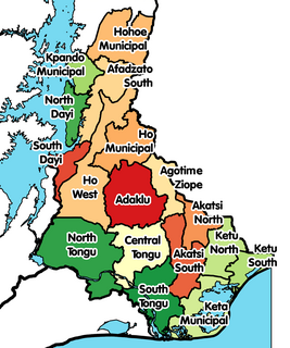
South Dayi District is one of the eighteen districts in Volta Region, Ghana. Originally it was formerly part of the then-larger Kpando District on 10 March 1989, until the southern part of the district was split off by a decree of president John Agyekum Kufuor on 19 August 2004 to create South Dayi District; thus the remaining part has been retained as Kpando District. The district assembly is located in the western part of Volta Region and has Kpeve as its capital town.
The Dinder River is a tributary of the Blue Nile. It flows through Ethiopia and Sudan for 480 kilometres (300 mi).
The Lambas are an ethnic and linguistic group of people living in the Kéran and Doufelgou Districts (Préfecture) of the Kara Region in Northern Togo and in the Atakora and Donga Departments of Bénin, West Africa. The capital of the Kéran District is Kanté and the capital of the Doufelgou District is Niamtougou.
Katcha is a village in the Bassar Prefecture in the Kara Region of north-western Togo.
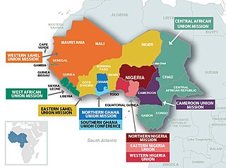
The West-Central Africa Division (WAD) of Seventh-day Adventists is a sub-entity of the General Conference of Seventh-day Adventists, which coordinates the Church's operations in 22 African countries, which include Benin, Burkina Faso, Cameroon, Cape Verde, Central African Republic, Chad, Congo, Equatorial Guinea, Gabon, Gambia, Ghana, Guinea, Guinea-Bissau, Ivory Coast, Liberia, Mali, Mauritania, Niger, Nigeria, Senegal, Sierra Leone, and Togo. Its headquarters is in Abidjan, Côte d'Ivoire. The Division membership as of June 30, 2021 is 889,196

Have is a town located in the western valley of the Akwapim Togo mountain range, locally called Ewetogbeka or Nyito, in the Afadzato South District of the Volta Region of Ghana. It is bounded on the south by Agate, on the north by Nyagbo, on the east by the mountain range and in the west by river Dayi. The citizens of Have are called Haveawo.

