
Regent Street is a major shopping street in the West End of London. It is named after George, the Prince Regent and was laid out under the direction of the architect John Nash and James Burton. It runs from Waterloo Place in St James's at the southern end, through Piccadilly Circus and Oxford Circus, to All Souls Church. From there Langham Place and Portland Place continue the route to Regent's Park.

Bristol city centre is the commercial, cultural and business centre of Bristol, England. It is the area north of the New Cut of the River Avon, bounded by Clifton Wood and Clifton to the north-west, Kingsdown and Cotham to the north, and St Pauls, Lawrence Hill and St Phillip's Marsh to the east. The Bristol Royal Infirmary, Bristol Royal Hospital for Children, BBC Broadcasting House, the main campus of the University of Bristol, Bristol Crown Court and Magistrate's Courts, Temple Meads railway station, Bristol bus station, the Park Street, Broadmead and Cabot Circus shopping areas together with numerous music venues, theatres and restaurants are located in this area. The area consists of the council wards of Central, Hotwells & Harbourside, and part of Lawrence Hill.

Bristol is a city with a population of nearly half a million people in south west England, situated between Somerset and Gloucestershire on the tidal River Avon. It has been among the country's largest and most economically and culturally important cities for eight centuries. The Bristol area has been settled since the Stone Age and there is evidence of Roman occupation. A mint was established in the Saxon burgh of Brycgstow by the 10th century and the town rose to prominence in the Norman era, gaining a charter and county status in 1373. The change in the form of the name 'Bristol' is due to the local pronunciation of 'ow' as 'ol'.

Broadmead is a street in the central area of Bristol, England, which has given its name to the principal shopping district of the city. It is part of Bristol Shopping Quarter.
Cribbs Causeway is both a road in South Gloucestershire, England, running north of the city of Bristol, and the adjacent area which is notable for its out-of-town shopping and leisure facilities. The retail and leisure complex takes its name from the road, and includes retail parks, supermarkets, an enclosed shopping centre known as The Mall, an ice-rink, Vue, a cinema, Hollywood Bowl, a ten-pin bowling venue, and a gym.
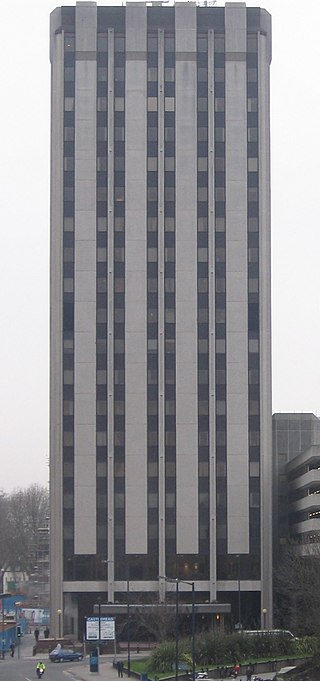
Castlemead is the second tallest high-rise building in Bristol, England, after Castle Park View topped out in 2020. Designed by A.J. Hines and started in 1973, work was halted by a recession in the property market and it was completed in 1981. The building has a roof height of 80 metres or 262 feet and consists of 18 floors, 17 of which are offices. Castlemead is owned by Regional Properties Ltd and managed by Knight Frank LLP.

Bristol, the largest city in South West England, has an eclectic combination of architectural styles, ranging from the medieval to 20th century brutalism and beyond. During the mid-19th century, Bristol Byzantine, an architectural style unique to the city, was developed, and several examples have survived.

The Galleries is a shopping mall situated in the Broadmead shopping centre in Bristol city centre, England. Functioning as one of the city's retail malls, it is a three-Storey building, which spans over Fairfax Street.

Cabot was an electoral ward that covered the centre of Bristol, England. It was represented by two members on Bristol City Council.

Masshouse is a development site in the Eastside area of Birmingham, England. Its name derives from a Roman Catholic Church built in 1687. Buildings were cleared to make way for the inner city ring road and car parking in the 1960s. Birmingham City Council wished to expand the city centre eastwards and an elevated road junction, Masshouse Circus was demolished in 2002 to facilitate redevelopment.

The English city of Bristol has a number of parks and public open spaces.

Quakers Friars is a Grade 1 Listed building in Broadmead, Bristol. Part of the former Blackfriars Priory site, it was used as a Quaker meeting house for nearly three hundred years, more recently serving as a registry office, a theatre, and a series of restaurants. It is an important site in both the early history of the Dominican Order in England and of the Religious Society of Friends (Quakers).
Princesshay is a shopping precinct in the city of Exeter, Devon, England. It was built in the early 1950s to replace buildings that had been severely damaged in the World War II Baedeker Blitz. From 2005 the precinct and some surrounding buildings were demolished and rebuilt as a new shopping centre that opened in September 2007.
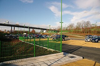
The Portway park and ride site is on the A4 Portway at Shirehampton, to the north-west of Bristol, England, close to junction 18 of the M5 motorway.

The Carriage Works are in Stokes Croft, Bristol, England.

Old Market is a Conservation Area of national significance, to the east of the city centre in Bristol, England. Old Market Street and West Street form the central axis of the area, which is approximately bounded by New Street and Lawfords Gate to the north, Trinity Road and Trinity Street to the east, Unity Street and Waterloo Road to the south and Temple Way Underpass to the west.

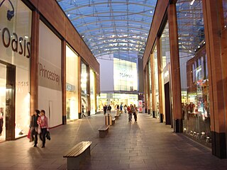
Cabot Circus is a covered shopping centre in Bristol, England. It is adjacent to Broadmead, a shopping district in Bristol City Centre. The Cabot Circus development area contains shops, offices, a hotel, 250 apartments and formerly, a cinema. It covers a total of 139,350 m2 (1,500,000 sq ft) floor space, of which 92,900 m2 (1,000,000 sq ft) is retail outlets and leisure facilities. It opened in September 2008, after a ten-year planning and building project costing £500 million.

St Jude's is a mixed residential, commercial and light industrial area of central Bristol, England. St Jude's forms part of the Lawrence Hill ward of Bristol City Council.

Finzels Reach is a 4.7-acre (1.9 ha) mixed use development site located in central Bristol, England, on a former industrial site, which occupies most of the south bank of Bristol Floating Harbour between Bristol Bridge and St Philip's Bridge, across the river from Castle Park.

Westmoreland House was a building at Nos. 104–106 Stokes Croft, Bristol, next door to the Carriage Works.

