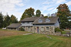
Tollhouse

Last updated
Northgate Toll House, Aberaeron Northgate Toll House SN4663 073.jpg
Northgate Toll House, Aberaeron

A tollhouse or toll house is a building with accommodation for a toll collector, beside a tollgate on a toll road, canal, or toll bridge.

Contents

History

Many tollhouses were built by turnpike trusts in England, Wales and Scotland during the 18th and early 19th centuries. Those built in the early 19th century often had a distinctive bay front to give the pikeman a clear view of the road and to provide a display area for the tollboard. [1] In 1840, according to the Turnpike Returns in Parliamentary Papers, there were over 5,000 tollhouses operating in England. These were sold off in the 1880s when the turnpikes were closed. Many were demolished but several hundred have survived for residential or other use, with distinctive features of the old tollhouses still visible.

Canal toll houses were built in very similar style to those on turnpikes. They are sited at major canal locks or at junctions. The great age of canal-building in Britain was in the 18th century, so the majority exhibit the typical features of vernacular Georgian architecture. In the English Midlands, a major area of 18th century canal development, most are of mellow red brick and hexagonal in plan, and tall enough to give the lock keeper a good view of local traffic on the canal. Being small, most have proved unsuitable for occupation, and so are often used as shops or tourist information outlets.[ citation needed ]

The manager's office in modern toll plazas in the United States is also referred to as a "toll house" even though it is not used as a residence.[ citation needed ]

See also

Related Research Articles

<span class="mw-page-title-main">Liskeard and Looe Union Canal</span> Former canal in Cornwall, United Kingdom

The Liskeard and Looe Union Canal was a broad canal between Liskeard and Looe in Cornwall, United Kingdom. It was almost 6 miles (9.7 km) long and had 24 locks, and it opened progressively from 1827. The engineer was Robert Coad.

<span class="mw-page-title-main">A30 road</span> Major road in England

The A30 is a major road in England, running 284 miles (457 km) WSW from London to Land's End.

<span class="mw-page-title-main">History of the British canal system</span> Building, use, decline and restoration of artificial waterways in the United Kingdom

The canal network of the United Kingdom played a vital role in the Industrial Revolution. The UK was the first country to develop a nationwide canal network which, at its peak, expanded to nearly 4,000 miles in length. The canals allowed raw materials to be transported to a place of manufacture, and finished goods to be transported to consumers, more quickly and cheaply than by a land based route. The canal network was extensive and included feats of civil engineering such as the Anderton Boat Lift, the Manchester Ship Canal, the Worsley Navigable Levels and the Pontcysyllte Aqueduct.

<span class="mw-page-title-main">History of Devon</span>

Devon is a county in south west England, bordering Cornwall to the west with Dorset and Somerset to the east. There is evidence of occupation in the county from Stone Age times onward. Its recorded history starts in the Roman period when it was a civitas. It was then a separate kingdom for a number of centuries until it was incorporated into early England. It has remained a largely agriculture based region ever since though tourism is now very important.

<span class="mw-page-title-main">Exeter Ship Canal</span> Canal in the United Kingdom

The Exeter Ship Canal, also known as the Exeter Canal is a canal leading from the River Exe to Exeter Quay in the city of Exeter, Devon, England. It was first constructed in the 1560s predating the "canal mania" period and is one of the oldest artificial waterways in the UK.

<span class="mw-page-title-main">Turnpike trust</span> Bodies established to run toll roads and improve transport routes

Turnpike trusts were bodies set up by individual acts of Parliament, with powers to collect road tolls for maintaining the principal roads in Britain from the 17th but especially during the 18th and 19th centuries. At the peak, in the 1830s, over 1,000 trusts administered around 30,000 miles (48,000 km) of turnpike road in England and Wales, taking tolls at almost 8,000 toll-gates and side-bars.

<span class="mw-page-title-main">Hayle Estuary</span> Estuary in Cornwall, England

The Hayle Estuary is an estuary in west Cornwall, England, United Kingdom. It is one of the few natural harbours on the north coast of south-west England and during the prehistoric and early medieval periods was important for trade and the movement of people and ideas.

<span class="mw-page-title-main">Sparrows Herne Turnpike Road</span> 18th century English toll road

Sparrows Herne Turnpike Road from London to Aylesbury was an 18th-century English toll road passing through Watford and Hemel Hempstead. The route was approximately that of the original A41 road; the Edgware Road, through Watford, Kings Langley, Apsley, the Boxmoor area of Hemel Hempstead, Berkhamsted, Northchurch, Cow Roast and Tring. Much of this part is now numbered the A4251 road. It linked in with other turnpikes to the north forming a route to Birmingham.

<span class="mw-page-title-main">Countess Wear</span> Area of Exeter in Devon, England

Countess Wear is a district within the city of Exeter, Devon, England. It lies about two miles south-east of the city centre, on the north bank of the estuary of the River Exe. Historically an estate known as Weare, part of the manor of Topsham, was in this area. From the late 13th century, the construction of weirs in the River Exe by the Countess, and later, the Earls of Devon damaged the prosperity of Exeter to the benefit of Topsham which was downstream of the obstructions, and was owned by the Earls.

<span class="mw-page-title-main">Engine Arm</span>

The Engine Arm or Birmingham Feeder Arm near Smethwick, West Midlands, England, is a short canal which was originally part of a feeder tunnel for a pumping engine. When the Smethwick flight of locks were reduced from six to three, the pumping engine was moved to a new site, which allowed part of the feeder tunnel to be opened up and made navigable, so that coal supplies for the engine could be delivered by barge. The Engine Arm also supplied the pumped water to the 473-foot (144 m) Wolverhampton level of the lowered summit. The arm was extended between 1825 and 1830 by Thomas Telford to carry water from Rotton Park Reservoir to the Old Main Line of the BCN Main Line Canal, and the Engine Arm Aqueduct was inserted to carry it over the new main line constructed at that time, which was 20 feet (6.1 m) lower. The arm is now managed by the Canal and River Trust and the basin beyond the site of the pumping station, which was replaced by a new engine house near Brasshouse Lane bridge in 1892, is used for residential moorings.

The BCN Main Line, or Birmingham Canal Navigations Main Line is the evolving route of the Birmingham Canal between Birmingham and Wolverhampton in England.

<span class="mw-page-title-main">Tipton Green and Toll End Canals</span> Defunct canal system near Tipton, West Midlands

The Tipton Green Branch and Toll End Branch were narrow canals comprising part of the Birmingham Canal Navigations near Tipton, West Midlands, England. These canals no longer exist.

<span class="mw-page-title-main">A382 road</span> Road in Devon, England

The A382 is a road in South West England, connecting Newton Abbot to the A38, then to Bovey Tracey and on through Moretonhampstead to the A30.

<span class="mw-page-title-main">North Tamerton</span> Village and civil parish in east Cornwall, England

North Tamerton is a village and civil parish in east Cornwall, England, UK. The village is situated approximately eight miles (13 km) southeast of Bude and eight miles (13 km) north of Launceston.

St Blazey Gate is a settlement in south Cornwall, England, United Kingdom in the civil parish of St Blaise. It is situated between the towns of St Blazey and Par on the A390 to St Austell.

<span class="mw-page-title-main">Bathampton Toll Bridge</span> Bridge in Somerset, England

Bathampton Toll Bridge is an arch bridge in England, carrying a minor road across the River Avon near Bathampton, to the east of Bath. It is a Grade II listed structure.

<span class="mw-page-title-main">Exeter</span> City in Devon, South West England

Exeter is a cathedral city and the county town of Devon, South West England. It is situated on the River Exe, approximately 36 mi (58 km) northeast of Plymouth and 65 mi (105 km) southwest of Bristol.

<span class="mw-page-title-main">Old Exe Bridge</span> Ruined medieval bridge in Devon, England

The Old Exe Bridge is a ruined medieval arch bridge in Exeter in south-western England. Construction of the bridge began in 1190, and was completed by 1214. The bridge is the oldest surviving bridge of its size in England and the oldest bridge in Britain with a chapel still on it. It replaced several rudimentary crossings which had been in use sporadically since Roman times. The project was the idea of Nicholas and Walter Gervase, father and son and influential local merchants, who travelled the country to raise funds. No known records survive of the bridge's builders. The result was a bridge at least 590 feet long, which probably had 17 or 18 arches, carrying the road diagonally from the west gate of the city wall across the River Exe and its wide, marshy flood plain.

<span class="mw-page-title-main">Richmond to Lancaster Turnpike</span> Former road in Northern England

The Richmond to Lancaster Turnpike, was a road that was opened in the second half of the 18th century between Richmond, in the North Riding of Yorkshire and Lancaster in Lancashire, Northern England. The turnpike was built to allow goods to be taken from Yorkshire to the port of Lancaster. It was approved in 1751, but was not wholly completed until 1774.

<span class="mw-page-title-main">Newton Bushell Turnpike Trust</span>

The Newton Bushell Turnpike Trust was a turnpike trust company in Devon which built and maintained trunk road connections from the West of Newton Bushell (now Newton Abbot between 1760 and November 1872. The trust built several roads, including what is now the A382 from Newton to Whiddon Down and the A383 to Ashburton.

References

  1. Tollhouse architecture, turnpke.org.uk, archived from the original on 12 August 2014, retrieved 18 September 2014

Bibliography

Tollhouses in England: