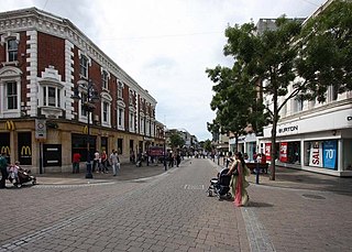
Gravesend is a town in northwest Kent, England, situated 21 miles (35 km) east-southeast of Charing Cross on the south bank of the River Thames and opposite Tilbury in Essex. Located in the diocese of Rochester, it is the administrative centre of the borough of Gravesham. Gravesend marks the eastern limit of the Greater London Built-up Area, as defined by the UK Office for National Statistics. In 2021 it had a population of 58,102.

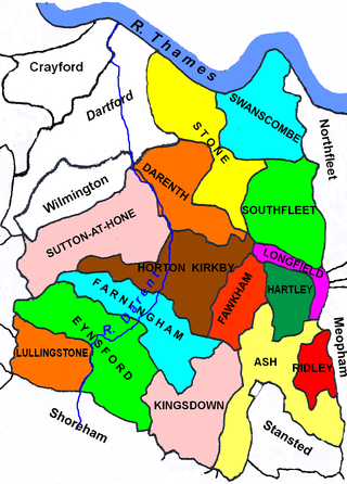
Gravesham is a local government district with borough status in north-west Kent, England. The council is based in its largest town of Gravesend. The borough is indirectly named after Gravesend, using the form of the town's name as it appeared in the Domesday Book of 1086. The district also contains Northfleet and a number of villages and surrounding rural areas.

Cobham is a village and civil parish in the borough of Gravesham in Kent, England. The village is located 6 miles (10 km) south-east of Gravesend, and just south of Watling Street, the Roman road from Dover to London. The parish, which includes the hamlet of Sole Street, covers an area of 1,240 hectares and had a population of 1,469 at the 2011 census, increasing from 1,328 at the 2001 census.

Swanscombe /ˈswɒnzkəm/ is a village in the Borough of Dartford in Kent, England, and the civil parish of Swanscombe and Greenhithe. It is 4.4 miles west of Gravesend and 4.8 miles east of Dartford.

Northfleet is a town in the borough of Gravesham in Kent, England. It is located immediately west of Gravesend, and on the border with the Borough of Dartford. Northfleet has its own railway station on the North Kent Line, just east of Ebbsfleet International railway station on the High Speed 1 line. According to the 2021 census, Northfleet has a population of 29,900.

Meopham is a large linear village and civil parish in the Borough of Gravesham in north-west Kent, England, lying to the south of Gravesend. The parish covers 6.5 square miles (17 km2), and comprises two villages and two smaller settlements; it had a population of 6,795 at the 2021 census. Meopham village is sometimes described as the longest settlement in England although others such as Brinkworth which is one village make the same claim. Meopham is one of the longest linear settlements in Europe, being 7 miles (11 km) in length.

Milton-next-Gravesend is an area and ecclesiastical parish, part of the Gravesend built-up area, in the Gravesham district, north-west of Kent, England.
Southfleet is a small village and civil parish in the borough of Dartford in Kent, England. The village is located three miles southwest of Gravesend, while the parish includes within its boundaries the hamlets of Betsham and Westwood.

Chalk is a village and since 1935 a former civil parish which adjoins the east of Gravesend, in the Gravesham district, in the county of Kent, England. As is intuitive, its name comes from the Saxon word cealc meaning a chalkstone.

Wrotham is a village on the Pilgrims' Way in Kent, England, at the foot of the North Downs. It is 1 mile (1.6 km) north of Borough Green and approximately 5 miles (8 km) east of Sevenoaks. It is between the M20 and M26 motorways.
Strood Rural District was a rural district in the county of Kent, England.

Cliffe Woods is a small estate on the Hoo Peninsula in the unitary authority of Medway in South East England. It was, until 1998, part of Kent and is still ceremonially associated via the Lieutenancies Act. It forms part of the parish of Cliffe and Cliffe Woods.

Gravesend was a county constituency centred on the town of Gravesend, Kent which returned one Member of Parliament (MP) to the House of Commons of the Parliament of the United Kingdom from 1868 until it was abolished for the 1983 general election. It is most notable for being a bellwether, with the winner of Gravesend winning every election from 1918 through to the present day except for 1929, 1951, and 2005.
New Barn is a village in Kent, England. It is a compact residential area surrounded by open fields which lies four miles southwest of Gravesend. It is in the local government district of Dartford. The villages of New Barn and Longfield are within and give their names to the civil parish of Longfield and New Barn. New Barn is larger in population than Longfield, although has little in the way of services, being a recent development and purely residential in nature

Sutton-at-Hone is a village in the civil parish of Sutton-at-Hone and Hawley in the Borough of Dartford in Kent, England. It is located 3.5 miles south of Dartford & 3.6 miles north east of Swanley.

Singlewell or Ifield is the name given to the area south of Gravesend in Kent, England.
Axstane was a hundred in the county of Kent, England. The Hundred of Axstane lay south-east of Dartford and Wilmington Hundred. It is called Achestan in Domesday Book, but by the reign of Edward I it was called Axstane.
Nurstead or Nursted is a locality, ecclesiastical parish and former civil parish, now in the parish of Meopham, in the Gravesham district, in the county of Kent, England. It is situated 3 miles south of Gravesend and ½ a mile north of Meopham.

The Latheof Sutton-at-Hone historically included a large part of Kent: the present-day boroughs of Dartford, Bexley, Greenwich, Bromley, Lewisham, Sevenoaks District and small parts of the Borough of Tonbridge and Malling and Borough of Tunbridge Wells.

The Lathe of Scray is an historic division of the county of Kent, England, encompassing the present-day Districts of Swale, Ashford, and the eastern part of Tunbridge Wells The Lathes of Kent were ancient administration divisions originating, probably, in the 6th century, during the Jutish colonisation of the county.