
An automotive navigation system is part of the automobile controls or a third party add-on used to find direction in an automobile. It typically uses a satellite navigation device to get its position data which is then correlated to a position on a road. When directions are needed routing can be calculated. On the fly traffic information can be used to adjust the route.

TomTom N.V. is a Dutch multinational developer and creator of location technology and consumer electronics. Founded in 1991 and headquartered in Amsterdam, TomTom released its first generation of satellite navigation devices to market in 2004. As of 2019 the company has over 4,500 employees worldwide and operations in 29 countries throughout Europe, Asia-Pacific, and the Americas.
Satellite navigation software or GNSS navigation software a category of software that provide positioning services by utilizing data from satellite navigation systems.

A satellite navigation device or satnav device, also known as a satellite navigation receiver or satnav receiver or simply a GPS device, is a user equipment that uses satellites of the Global Positioning System (GPS) or similar global navigation satellite systems (GNSS). A satnav device can determine the user's geographic coordinates and may display the geographical position on a map and offer routing directions.

Here Technologies is a Dutch multinational group specialized in mapping technologies, location data, and related automotive services to individuals and companies. It is majority-owned by a consortium of German automotive companies and American semiconductor company Intel whilst other companies also own minority stakes. Its roots date back to U.S.-based Navteq in 1985, which was acquired by Finland-based Nokia in 2007. Here is currently based in The Netherlands.
Google Maps Navigation is a mobile application developed by Google for the Android and iOS operating systems that later integrated into the Google Maps mobile app. The application uses an Internet connection to a GPS navigation system to provide turn-by-turn voice-guided instructions on how to arrive at a given destination. The application requires a connection to Internet data and normally uses a GPS satellite connection to determine its location. A user can enter a destination into the application, which will plot a path to it. The app displays the user's progress along the route and issues instructions for each turn.

Sygic is a Slovak company of global automotive navigation systems for mobile phones and tablets. The company was founded in 2004 and is headquartered in Bratislava, Slovakia. It became the first company to offer navigation for iPhone and second for Android. In 2015 Sygic reached milestone of 100 million downloads of its navigation app.
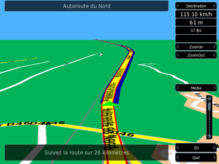
Turn-by-turn navigation is a feature of some satellite navigation devices where directions for a selected route are continually presented to the user in the form of spoken or visual instructions. The system keeps the user up-to-date about the best route to the destination, and is often updated according to changing factors such as traffic and road conditions. Turn-by-turn systems typically use an electronic voice to inform the user whether to turn left or right, the street name, and the distance to the next turn.
Telenav, Inc. is a wireless location-based services corporation that provides services including Global Positioning System (GPS) satellite navigation, local search, automotive navigation solutions, mobile advertising, enterprise mobility and workflow automation. The company’s headquarters are located in Santa Clara, California in the United States with additional offices in the U.S., Germany, Japan, Romania, China, and Brazil.
This is a list of notable commercial satellite navigation software for various devices, with a specific focus on mobile phones, tablets, tablet PCs,.

OsmAnd is a free and open-source map and navigation app for Android and iOS. It uses the OpenStreetMap (OSM) map database for its primary displays, but is an independent app not endorsed by the OpenStreetMap Foundation. It is available in both free and paid versions; the latter unlocks the download limit for offline maps and provides access to Wikipedia points of interest (POIs) and their descriptions from within the app. Map data can be stored on the device for offline use. Using the device's GPS capabilities, OsmAnd offers routing, with visual and voice guidance, for car, bike, and pedestrian. All of the main functionalities work both online and offline.
My Tracks was a Global Positioning System (GPS) tracking application that ran on Android. The application used a device's GPS capabilities to collect data, allowing real-time review of path, speed, distance, and elevation. Later, this data could be saved to Google Maps, Google Fusion Tables, or Google Docs and shared with Google+, Facebook, or Twitter. The application also allowed a user to record annotations along the path, hear periodic voice announcements of progress, and sync with select third-party bio-metric sensors.
This article contains a list with gratis satellite navigation software for a range of devices. Some of the free software mentioned here does not have detailed maps or the ability to follow streets or type in street names. However, in many cases, it is also that which makes the program free, avoid the need of an Internet connection, and make it very lightweight. Very basic programs like this may not be suitable for road navigation in cars, but serve their purpose for navigation while walking or trekking, and for use at sea. To determine the GPS coordinates of a destination, one can use sites such as GPScoordinates.eu and GPS visualizer.

Android Auto is a mobile app developed by Google to mirror features of a smartphone on a car's dashboard information and entertainment head unit.

Here WeGo is a web mapping and satellite navigation software, operated by HERE Technologies and available on the Web and mobile platforms. It is based on HERE's location data platform, providing its in-house data, which includes satellite views, traffic data, and other location services. Maps are updated every two or three months.

Locus Map is a multi-functional Android navigation app. Primarily it is designed and used for leisure time outdoor activities like hiking, biking, or geocaching. The app is also used by professionals e.g. by S&R teams or for collecting geospatial data.

Karta GPS is a mobile application developed by Karta Software Technologies Lda., a daughter company of NDrive, for the Android, iOS and iPadOS operating systems. It is distributed for free and pairs open-source map data from OpenStreetMap alongside curated content from Yelp and Foursquare.
Car apps are a genre of software that offer a car and its driver abilities above what is built-in to the vehicle. Examples of Third-party software for cars include allowing data input while moving, traffic jam assistance, diagnostics and lane-keeping.