
Thurso is a town and former burgh on the north coast of the Highland council area of Scotland. Situated in the historical County of Caithness, it is the northernmost town on the island of Great Britain. From a latitudinal standpoint, Thurso is located further north than the southernmost point of Norway and in addition lies more than 500 miles (800 km) north of London.

Rona, sometimes called South Rona to distinguish it from North Rona, is an inhabited island in the Inner Hebrides. It lies between the Sound of Raasay and the Inner Sound just north of the neighbouring island of Raasay and east of the Trotternish peninsula of Skye. It has a total area of 930 hectares (3.6 sq mi) and a population of 3.
South Ronaldsay is one of the Orkney Islands off the north coast of Scotland. It is linked to the Orkney Mainland by the Churchill Barriers, running via Burray, Glimps Holm and Lamb Holm.
Great Bernera, often known just as Bernera, is an island and community in the Outer Hebrides of Scotland. With an area of just over 21 square kilometres, it is the thirty-fourth largest Scottish island.

Stroma is an uninhabited island in the Pentland Firth, between Orkney and the mainland of Scotland. It forms part of the civil parish of Canisbay in Caithness, in the council area of Highland. The name comes from the Old Norse Straumey, meaning "island in the current".

Tongue is a coastal village in northwest Highland, Scotland, in the western part of the former county of Sutherland. It lies on the east shore above the base of the Kyle of Tongue and north of the mountains Ben Hope and Ben Loyal on the A836. To the north lies the area of Braetongue.
Scarp is an uninhabited island in the Outer Hebrides of Scotland, west of Hushinish on Harris. Once inhabited, the island was the scene of unsuccessful experiments with rocket mail, since commemorated in two films.
Barra Head, also known as Berneray, is the southernmost island of the Outer Hebrides in Scotland. Within the Outer Hebrides, it forms part of the Barra Isles archipelago. Originally, Barra Head only referred to the southernmost headland of Berneray but is now a common name for the entire island. The highest point of the island is Sotan, a Marilyn.

Coldbackie is a crofting township in Sutherland and is in the Scottish council area of Highland Scotland.
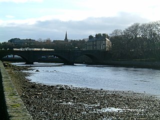
Wick is a town and royal burgh in Caithness, in the far north of Scotland. The town straddles the River Wick and extends along both sides of Wick Bay. "Wick Locality" had a population of 6,954 at the time of the 2011 census, a decrease of 3.8% from 2001.

Tarskavaig is a crofting village on the west coast of Sleat on the Isle of Skye in Scotland. It sits in a glen which meets Tarskavaig Bay and lies opposite the Isles of Eigg, Rum and Canna. It is often said that Tarskavaig has the best view of the Cuillin in Skye and is home to the oldest sheep in the world.

Eilean nan Ròn is an island near Skerray, in the north of Sutherland, Scotland. An estimated 350 seal pups are born here annually.

The Rabbit Islands are a group of three uninhabited small islands off the north coast of Sutherland, Scotland in Tongue Bay. In Scottish Gaelic, and occasionally in English, they are known as Eileanan nan Gall, which is sometimes anglicised as "Eilean-na-Gaeil" or "Eilean nan Gaill".

Scullomie is a small fishing and crofting township at the head of Tongue Bay in Sutherland in the Scottish Highlands. It is located around 3 miles (4.8 km) north of the village of Tongue on the northern coast of Scotland and is in the Scottish council area of Highland. The place name is spelled Skullomie on some Ordnance Survey maps.

Lewis and Harris, or Lewis with Harris, is a Scottish island in the Outer Hebrides, around 24 miles (39 km) from the Scottish mainland.

Skerray is a remote small crofting hamlet and fishing port on the north coast of Sutherland, Scotland. It is located 7+3⁄4 miles by road northeast of Tongue and 40+1⁄4 miles by road west of Thurso. Skerray is home to a community of artists and a group of tree planters.

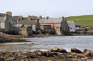
Talmine is a crofting and fishing township, overlooking Talmine Bay, an inlet on the western shore of Tongue Bay in northern Sutherland, Scottish Highlands and is in the Scottish council area of Highland. The Reaper, an old fishing boat located within the bay. She can be seen in the photo to the right, on the beach, underneath/between the stone building and blue car roughly centre image.
Evans Piedmont Glacier is a broad ice sheet occupying the low-lying coastal platform between Tripp Island and Cape Archer in Victoria Land, Antarctica.

Skerray Bay is an arm of the Atlantic Ocean, located on the north coast of Sutherland, Highland, Scotland. Small and rocky, it is situated to the north of Clashbuie and northwest of the crofting community of Skerray. The rock, Càrn Mòr, it at the entrance, while the channel, Caol Beag, separates Coomb Island from the mainland. Strathan Skerray - Skerray Bay is a Geological Conservation Review site. Walkers enjoy the 8 miles (13 km) Skerray Bay to Tongue trek.
Mugeary is a farm or croft and former settlement on the island of Skye, Scotland. Located 4 kilometres southwest of Portree, it is known as the location where the basaltic rock mugearite was first identified. The Gaelic name is derived from Old Norse and probably means "narrow field".
