Tongue River (North Dakota)

Last updated
The Tongue River in Icelandic State Park Tongue River North Dakota.jpg
The Tongue River in Icelandic State Park

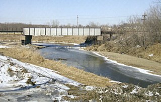
The Tongue River is a 90.4-mile-long (145.5 km) [1] tributary of the Pembina River in northeastern North Dakota in the United States. It drains an area of the prairie country near the Canada–US border in the extreme northeast corner of the state in the watershed of the Red River.

North Dakota State of the United States of America

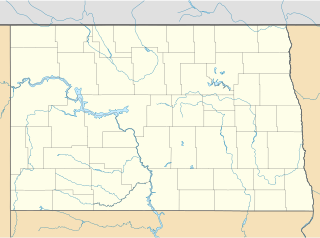
North Dakota is a U.S. state in the midwestern and northern regions of the United States. It is the nineteenth largest in area, the fourth smallest by population, and the fourth most sparsely populated of the 50 states. North Dakota was admitted to the Union on November 2, 1889, along with its neighboring state, South Dakota. Its capital is Bismarck, and its largest city is Fargo.

United States federal republic in North America

The United States of America (USA), commonly known as the United States or America, is a country composed of 50 states, a federal district, five major self-governing territories, and various possessions. At 3.8 million square miles, the United States is the world's third or fourth largest country by total area and is slightly smaller than the entire continent of Europe's 3.9 million square miles. With a population of over 327 million people, the U.S. is the third most populous country. The capital is Washington, D.C., and the largest city by population is New York City. Forty-eight states and the capital's federal district are contiguous in North America between Canada and Mexico. The State of Alaska is in the northwest corner of North America, bordered by Canada to the east and across the Bering Strait from Russia to the west. The State of Hawaii is an archipelago in the mid-Pacific Ocean. The U.S. territories are scattered about the Pacific Ocean and the Caribbean Sea, stretching across nine official time zones. The extremely diverse geography, climate, and wildlife of the United States make it one of the world's 17 megadiverse countries.

Prairie ecosystems considered part of the temperate grasslands, savannas, and shrublands biome

Prairies are ecosystems considered part of the temperate grasslands, savannas, and shrublands biome by ecologists, based on similar temperate climates, moderate rainfall, and a composition of grasses, herbs, and shrubs, rather than trees, as the dominant vegetation type. Temperate grassland regions include the Pampas of Argentina, Brazil and Uruguay, and the steppe of Ukraine, Russia and Kazakhstan. Lands typically referred to as "prairie" tend to be in North America. The term encompasses the area referred to as the Interior Lowlands of Canada, the United States, and Mexico, which includes all of the Great Plains as well as the wetter, hillier land to the east.

Contents

It rises in eastern Cavalier County and flows in a direct course east-northeast into Pembina County, passing the towns of Cavalier, Neche and Bathgate. It joins the Pembina from the south approximately 2 miles (3 km) upstream from the mouth of the Pembina on the Red River.

Cavalier County, North Dakota County in the United States

Cavalier County is a county in the U.S. state of North Dakota. It is south of the Canada–US border with Manitoba. As of the 2010 United States Census, the population was 3,993. Its county seat is Langdon. The city of Cavalier is in nearby Pembina County.

Pembina County, North Dakota County in the United States

Pembina County is a county in the U.S. state of North Dakota. At the 2010 United States Census its population was 7,413. The county seat is Cavalier.

Cavalier, North Dakota City in North Dakota, United States

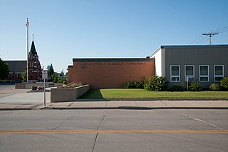
Cavalier is the largest city in Pembina County, North Dakota, United States. It is the county seat of Pembina County. The population was 1,302 at the 2010 census. Cavalier was founded in 1875 and became the county seat in 1911.

Upstream of Cavalier, the river passes through Icelandic State Park, where Renwick Dam causes it to form Lake Renwick. Below the dam, foot trails follow the river in the Gunlogson Arboretum Nature Preserve.

Icelandic State Park

Icelandic State Park is a public recreation area located on Lake Renwick five miles (8.0 km) west of Cavalier in Akra Township, Pembina County, North Dakota. The state park's 912 acres (369 ha) include the Pioneer Heritage Center and the Gunlogson Homestead and Nature Preserve.

Renwick Dam

Renwick Dam is a dam in Akra Township, Pembina County, North Dakota, USA, in the northeastern corner of the state.

See also

Related Research Articles

Pembina, North Dakota City in North Dakota, United States

Pembina is a city in Pembina County, North Dakota, United States. The population was 592 at the 2010 census. Pembina is located 2 miles (3.2 km) south of the Canada–US border. Interstate 29 passes on the west side of Pembina, leading north to the Canada–US border at Emerson, Manitoba and south to the cities of Grand Forks and Fargo. The Pembina-Emerson Border Crossing is the busiest between Blaine, Washington and Detroit, Michigan and the fifth busiest along the Canada-United States border. It is one of three 24-hour ports of entry in North Dakota, the others being Portal and Dunseith. The Emerson-Noyes border crossing, located 2 miles (3.2 km) to the east on the Minnesota side of the Red River, also processed cross border traffic until its closure in 2006.

Walhalla, North Dakota City in North Dakota, United States

Walhalla is a city in Pembina County, North Dakota, United States. It sits on the banks of the Pembina River, five miles (8 km) from the border with Manitoba (Canada) and approximately 45 mi (72 km) from the border with Minnesota. The population was 996 at the 2010 census.

Pembina River (Manitoba – North Dakota) river in Manitoba and North Dakota

The Pembina River is a tributary of the Red River of the North, approximately 319 miles (513 km) long, in southern Manitoba in Canada and northeastern North Dakota in the United States. It drains an area of the prairie country along the Canada–US border, threading the Manitoba-North Dakota border eastward to the Red River. Via the Red River, Lake Winnipeg and the Nelson River, it is part of the watershed of Hudson Bay.

Maquoketa River river in the United States of America

The Maquoketa River is a tributary of the Mississippi River, approximately 150 miles (240 km) long, in northeastern Iowa in the United States. Its watershed covers 1,694 square miles (4,387 km2) within a rural region of rolling hills and farmland southwest of Dubuque. It is not to be confused with the Little Maquoketa River, another distinct direct tributary of the Upper Mississippi River meeting the Big River north of Dubuque. The river and its tributaries mark the border of the Driftless Area of Iowa, with the areas east of it not having been covered by ice during the last ice age. Its name derives from Maquaw-Autaw, which means "Bear River" in Meskwaki.

Lake Entiat is a reservoir between Chelan County and Douglas County in North Central Washington, USA, that is formed above Rocky Reach Dam, a hydroelectric dam on the Columbia River. The reservoir is 17 mi (27 km) north of Wenatchee and stretches upstream to the Wells Dam. Lincoln Rock State Park is on its south shore.

Turtle River (North Dakota) river in North Dakota

The Turtle River is a 74.9-mile-long (120.5 km) tributary of the Red River of the North in northeastern North Dakota in the United States. It flows for almost its entire length in Grand Forks County. Via the Red River, Lake Winnipeg and the Nelson River, the Turtle River is part of the watershed of Hudson Bay.

The Middle River is a tributary of the Snake River in northwestern Minnesota in the United States. It flows for its entire length in Marshall County.

Akra Township, Pembina County, North Dakota Township in North Dakota, United States

Akra Township is a township in Pembina County, North Dakota, United States.

North Dakota Highway 5 is a 337-mile (542 km) long east–west state highway in North Dakota. Its route is in the extreme north part of the state, near the Canada–United States border. The eastern terminus is located about four miles east of Joliette at the Red River where the highway continues east as Minnesota State Highway 175. The western terminus is at North Dakota's western border about 12 miles (19 km) west of Fortuna where the highway continues west and turns into Montana Highway 5. The highway is mostly a two-lane road.

Pembina Escarpment

The Pembina Escarpment is a scarp that marks the boundary of glacial Lake Agassiz. It rises up to 300–400 feet (91–122 m) and occurs in South Dakota, North Dakota, and Manitoba.

Tomoka River river in the United States of America

The Tomoka River is a north-flowing river in Volusia County, Florida, United States. It drains an area of about 110 square miles (280 km2) and has a length of 19.6 miles (31.5 km).

East Branch Penobscot River river in the United States of America

The East Branch Penobscot River is a 75.3-mile-long (121.2 km) tributary of Maine's Penobscot River. It flows in Piscataquis County and Penobscot County.

Lincoln Rock State Park

Lincoln Rock State Park is a public recreation area on the east side of the Columbia River's Lake Entiat, seven miles (11 km) north of Wenatchee and one mile upstream from the Rocky Reach Dam. The state park covers 86 acres (35 ha) opposite the cliff formation for which it is named. The park provides views of the south end of Swakane Canyon and of Turtle Rock Island in Lake Entiat, a 150-acre nature preserve that was isolated from the mainland when the lake formed in the 1960s. The park offers water activities, including fishing, boating, and swimming, in addition to facilities for picnicking, camping, hiking, and field sports. It is managed by the Washington State Parks and Recreation Commission under a lease agreement with the owners, the Chelan County Public Utility District.

Pembina Gorge State Recreation Area

Pembina Gorge State Recreation Area is a unit of the North Dakota state park system located along the Pembina River that provides a 12-mile (19 km) looped trail for riding ATVs, dirt bikes, and other forms of off-road vehicles. Non-motorized use by equestrians, mountain bikers, and hikers is also allowed. In 2014 plants were collected in the Pembina Gorge. The final count was 209 species, which includes prior collections.

North Dakota Highway 89 (ND 89) is a 1.960-mile-long (3.154 km) north–south state highway in the U.S. state of North Dakota. ND 89's southern terminus is at the edge of the Cavalier Air Force Station, and the northern terminus is at ND 5 east of Langdon.

References

  1. U.S. Geological Survey. National Hydrography Dataset high-resolution flowline data. The National Map, accessed June 8, 2011

Coordinates: 48°56′10″N97°18′10″W / 48.93611°N 97.30278°W / 48.93611; -97.30278

Geographic coordinate system Coordinate system

A geographic coordinate system is a coordinate system that enables every location on Earth to be specified by a set of numbers, letters or symbols. The coordinates are often chosen such that one of the numbers represents a vertical position and two or three of the numbers represent a horizontal position; alternatively, a geographic position may be expressed in a combined three-dimensional Cartesian vector. A common choice of coordinates is latitude, longitude and elevation. To specify a location on a plane requires a map projection.