Pembina County, North Dakota

Last updated

Pembina County
Pembina County Courthouse.jpg
Map of North Dakota highlighting Pembina County.svg
Location within the U.S. state of North Dakota
North Dakota in United States.svg
North Dakota's location within the U.S.
Coordinates: 48°46′N97°33′W / 48.77°N 97.55°W / 48.77; -97.55
CountryFlag of the United States.svg United States
StateFlag of North Dakota.svg  North Dakota
FoundedJanuary 9, 1867 (created)
August 12, 1867 (organized)
Named for a Chippewa term
Seat Cavalier
Largest cityCavalier
Area
  Total1,121 sq mi (2,900 km2)
  Land1,119 sq mi (2,900 km2)
  Water2.7 sq mi (7 km2)  0.2%
Population
 (2020)
  Total6,844
  Estimate 
(2022)
6,763 Decrease2.svg
  Density6.1/sq mi (2.4/km2)
Time zone UTC−6 (Central)
  Summer (DST) UTC−5 (CDT)
Congressional district At-large
Website www.pembinacountynd.gov

Pembina County is a county in the U.S. state of North Dakota. At the 2020 census its population was 6,844. [1] The county seat is Cavalier. [2]

Contents

History

Frontier doctor Dr. Charles Boarman Harris, one of the original pioneers to settle in Pembina, was the first county physician. He delivered over 3,000 babies born in the region between 1882 and 1942. Dr. Charles Boarman Harris.jpg
Frontier doctor Dr. Charles Boarman Harris, one of the original pioneers to settle in Pembina, was the first county physician. He delivered over 3,000 babies born in the region between 1882 and 1942.

For thousands of years, various indigenous peoples inhabited the area along the Pembina and Red rivers. At the time of European contact in the 16th century, the dominant tribes were the Assiniboine and the Lakota (or Sioux, as the French colonists called them). The Ojibwe, also known as Chippewa, a branch of the Anishinaabe-speaking language group, gradually migrated west along both sides of the Great Lakes. They developed a long trading relationship with French trappers and colonists. Throughout the Red River of the North area, French trappers married Native American women, and their descendants continued to hunt and trap. A large mixed-race population developed, recognized as an ethnic First Nations group in Canada called the Métis . The Ojibwe and Métis generally supported the French forces during the Seven Years' War in the mid-eighteenth century against Great Britain.

With the British defeat of France and takeover of its colonial territory, the Chippewa learned to deal with a new trading culture. Armed with guns by trading and having adopted the horse from the Mandan and Hidatsa, by the end of the eighteenth century the Chippewa had migrated from woodlands to the Great Plains and begun to push the Lakota west before them. By the time of the War of 1812, the Ojibwe allied with the British against the United States, hoping to forestall European-American settlers' encroaching on their territory. With the settlement of the northern boundary with Canada, the Chippewa within the Dakota Territory were forced to deal with the United States. During the first half of the nineteenth century, the Chippewa had continued conflicts with the Lakota along the Red River, finally pushing them into present-day western North and South Dakota.

Father George Belcourt, a Catholic Jesuit missionary who served them, described their territory in 1849 as the following

We understand here, that the district or department called Pembina, comprises all of the country or basin which is irrigated or traversed by the tributaries of the Red River, south of the line of the 49th parallel of latitude. The prairies' rivers and lakes which extend to the height of land of the Mississippi, and the immense plains which feed innumerable herds of bison to the westward and from which the Chippewa and half breeds [Métis] of this region obtain their subsistence, contains within their limits a country about 400 miles from north to south and more than five hundred miles from east to west. [3]

The Métis used two-wheeled ox-drawn carts to transport furs to market along the Red River Trails, between what is now Winnipeg, Canada and Mendota or St. Paul, Minnesota. They also used ox-carts to transport food and shelter during extended buffalo hunts.

Over time, the Ojibwe were persuaded to cede much of their land by treaty to the US, which in turn sold it to homesteaders. They moved to relatively small Indian reservations within their earlier territory.

The precursor to Pembina County was a county of the same name in the Minnesota Territory, extending from the Upper Mississippi River to the western boundary of the territory. When Minnesota became a state in 1858, its western boundary was set at the Red River, and the land to its west was unorganized. A new Pembina County was established as part of the Dakota Territory in 1867. At the time it was a large territory, and in 1871 it was expanded to include much of the territory in what is now eastern North Dakota from Canada to the South Dakota border.

The Dakota Territory legislature created Pembina County on January 9, 1867, from previously unorganized territory. Its government was organized on August 12 of that same year. It was named for a Chippewa term for stab or stabbing. [4] Pembina, the oldest European-American settlement in the future state, was the county seat. In 1911 the seat was relocated to Cavalier. [5] [6]

The county boundaries were altered in 1871, 1873, 1881, and 1887. It has retained its present boundaries since 1887. Between 1873 and 1881, eleven new counties were created from Pembina, including Cass County and Grand Forks County. Pembina took its current form in 1887, when Cavalier County was increased in size. [7]

Icelandic State Park is located in Pembina County. The first Icelandic immigrant settlement in present-day North Dakota was in Pembina County in the late 1870s, when a colony of settlers from Iceland moved into the county from the New Iceland homesteads near Lake Winnipeg. [8]

Outline map of Pembina County, North Dakota, 1909 Map of Pembina County, N.D., 1909.jpg
Outline map of Pembina County, North Dakota, 1909

The first Icelandic settlements in what is now North Dakota were established in Pembina County in the late 1870s. Many of the immigrants came from New Iceland near Lake Winnipeg, along with other Icelanders who moved into the area from colonies in Wisconsin. The new settlers lived primarily in the so-called "Icelandic Townships" of Akra, Beaulieu, Gardar, and Thingwalla. The State Historical Society of North Dakota reported fewer than 3 or 4 non-Icelandic families living there in the early 1900s. Evidence of this heritage is found in several township and city names with Icelandic origins. Akra was named after the town of Akranes, near Reykjavík; Gardar was named for Gardar Svavarsson, who was reportedly the first Scandinavian to visit Iceland; and Hallsson was named for an early settler, Johann P. Hallson. [9]

Icelandic State Park was established to preserve evidence of this early pioneer heritage. [10]

Geography

Pembina County lies at the northeastern corner of North Dakota. Its northern boundary line abuts the southern boundary line of Canada and its eastern boundary line abuts the western boundary line of the state of Minnesota (across the Red River, which flows northward along the county's eastern boundary line). The Pembina River flows eastward through the upper portion of the county, discharging into the Red River near the northeastern county corner. The Tongue River flows northeastward through the upper portion of the county, discharging into the Pembina shortly before the Pembina joins the Red River. The county terrain consists of rolling hills, etched by river drainages. The area is devoted to agriculture. [11] The terrain slopes to the east and north; its highest point is on the lower western boundary line, at 1,302 feet (397 m) above sea level. [12] The county has a total area of 1,121 square miles (2,900 km2), of which 1,119 square miles (2,900 km2) is land and 2.7 square miles (7.0 km2) (0.2%) is water. [13] The lowest point in the state of North Dakota is located on the Red River of the North in Pembina Township in Pembina County, where it flows out of North Dakota and into the Canada–US border of Manitoba.

Major highways

Adjacent counties and rural municipalities

Protected areas [11]

Demographics

Historical population
CensusPop.Note
1870 1,213
1880 4,862300.8%
1890 14,334194.8%
1900 17,86924.7%
1910 14,749−17.5%
1920 15,1772.9%
1930 14,757−2.8%
1940 15,6716.2%
1950 13,990−10.7%
1960 12,946−7.5%
1970 10,728−17.1%
1980 10,399−3.1%
1990 9,238−11.2%
2000 8,585−7.1%
2010 7,413−13.7%
2020 6,844−7.7%
2022 (est.)6,763 [14] −1.2%
U.S. Decennial Census [15]
1790-1960 [16] 1900-1990 [17]
1990-2000 [18] 2010-2020 [1]

2020 census

At the census of 2020, there were 6,844 people.

2010 census

As of the census of 2010, there were 7,413 people, 3,257 households, and 2,069 families in the county. The population density was 6.62 people per square mile (2.56 people/km2). There were 3,859 housing units at an average density of 3.45 units per square mile (1.33/km2). The racial makeup of the county was 95.5% white, 1.9% American Indian, 0.3% black or African American, 0.1% Asian, 0.8% from other races, and 1.3% from two or more races. Those of Hispanic or Latino origin made up 2.6% of the population. In terms of ancestry, 33.8% were German, 21.3% were Norwegian, 10.6% were Irish, 9.5% were English, 8.0% were American, and 5.5% were Swedish.

Of the 3,257 households, 24.5% had children under the age of 18 living with them, 54.2% were married couples living together, 5.6% had a female householder with no husband present, 36.5% were non-families, and 32.4% of all households were made up of individuals. The average household size was 2.23 and the average family size was 2.82. The median age was 46.7 years.

The median income for a household in the county was $48,502 and the median income for a family was $61,804. Males had a median income of $40,334 versus $29,662 for females. The per capita income for the county was $27,019. About 4.0% of families and 8.0% of the population were below the poverty line, including 9.5% of those under age 18 and 11.3% of those age 65 or over.

Population by decade

Pembina County, North Dakota

Communities

Cities

Unincorporated communities

Townships

American Indian reservations

Ghost Town

Politics

Pembina County voters have traditionally backed the Republican Party. In only one national election since 1948 has the county selected the Democratic Party candidate (as of 2020).

United States presidential election results for Pembina County, North Dakota [19]
Year Republican Democratic Third party
No.%No.%No.%
2020 2,46073.85%78623.60%852.55%
2016 2,20870.03%68121.60%2648.37%
2012 1,89958.34%1,25338.49%1033.16%
2008 1,72252.07%1,49445.18%912.75%
2004 2,46663.95%1,32134.26%691.79%
2000 2,43064.30%1,09328.92%2566.77%
1996 1,67850.94%1,19136.16%42512.90%
1992 1,91746.45%1,18628.74%1,02424.81%
1988 2,47159.56%1,61638.95%621.49%
1984 2,89565.99%1,36731.16%1252.85%
1980 3,10165.73%1,23926.26%3788.01%
1976 2,81053.95%2,27443.66%1252.40%
1972 3,31763.75%1,80134.61%851.63%
1968 2,57456.01%1,68636.68%3367.31%
1964 1,96137.95%3,19861.89%80.15%
1960 3,34857.62%2,46042.34%20.03%
1956 3,07761.82%1,88737.91%130.26%
1952 4,01267.50%1,89131.81%410.69%
1948 2,40646.67%2,66651.72%831.61%
1944 2,41044.95%2,90354.15%480.90%
1940 2,92443.94%3,71155.76%200.30%
1936 2,04031.48%4,13963.86%3024.66%
1932 1,91134.19%3,63665.04%430.77%
1928 3,32460.75%2,14139.13%70.13%
1924 2,78359.02%58812.47%1,34428.50%
1920 3,92573.24%1,40526.22%290.54%
1916 1,46950.71%1,40048.33%280.97%
1912 61524.75%97539.24%89536.02%
1908 1,38952.55%1,18544.84%692.61%
1904 1,87070.01%74327.82%582.17%
1900 1,73255.34%1,32142.20%772.46%

See also

Related Research Articles

<span class="mw-page-title-main">Walsh County, North Dakota</span> County in North Dakota, United States

Walsh County is a county in the U.S. state of North Dakota. As of the 2020 census, the population was 10,563. Its county seat is Grafton.

<span class="mw-page-title-main">Towner County, North Dakota</span> County in North Dakota, United States

Towner County is a county in the U.S. state of North Dakota. As of the 2020 census, the population is 2,162. Its county seat is Cando. It is south of the Canada–US border with Manitoba.

<span class="mw-page-title-main">Cavalier County, North Dakota</span> County in North Dakota, United States

Cavalier County is a county in the U.S. state of North Dakota. It is south of the Canada–US border with Manitoba. As of the 2020 census, the population was 3,704. Its county seat is Langdon. The city of Cavalier is in nearby Pembina County.

<span class="mw-page-title-main">Kittson County, Minnesota</span> County in Minnesota, United States

Kittson County is a county in the northwestern corner of the U.S. state of Minnesota along the Canada–US border, south of the Canadian province of Manitoba. As of the 2020 census, the population was 4,207. Its county seat is Hallock.

Badger Township is a township in Polk County, Minnesota, United States. It is part of the Grand Forks-ND-MN Metropolitan Statistical Area. Under the United States Public Land Survey System it is a survey township identified as Township 149 North, Range 42 West, Fifth Principal Meridian. The population was 166 at the 2000 census.

<span class="mw-page-title-main">Pembina, North Dakota</span> City in North Dakota, United States

Pembina is a city in Pembina County, North Dakota, United States. The population was 512 at the 2020 census. Pembina is located 2 miles (3.2 km) south of the Canada–US border. Interstate 29 passes on the western side of Pembina, leading north to the Canada–US border at Emerson, Manitoba and south to the cities of Grand Forks and Fargo. The Pembina–Emerson Border Crossing is the busiest between Surrey–Blaine, and Windsor–Detroit, and the fifth busiest along the Canada-United States border. It is one of three 24-hour ports of entry in North Dakota, the others being Portal and Dunseith. The Noyes–Emerson East Border Crossing, located 2 miles (3.2 km) to the east on the Minnesota side of the Red River, also processed cross-border traffic until its closure in 2006.

<span class="mw-page-title-main">Red Lake Indian Reservation</span> Home to the federally recognized Red Lake Band of Ojibwe

The Red Lake Indian Reservation covers 1,260.3 sq mi in parts of nine counties in Minnesota, United States. It is made up of numerous holdings but the largest section is an area about Red Lake, in north-central Minnesota, the largest lake in the state. This section lies primarily in the counties of Beltrami and Clearwater. Land in seven other counties is also part of the reservation. The reservation population was 5,506 in the 2020 census.

<span class="mw-page-title-main">Turtle Mountain Band of Chippewa Indians</span> Native American tribe

The Turtle Mountain Band of Chippewa Indians is a federally recognized Native American tribe of Ojibwe based on the Turtle Mountain Indian Reservation in Belcourt, North Dakota. The tribe has 30,000 enrolled members. A population of 5,815 reside on the main reservation and another 2,516 reside on off-reservation trust land.

Advance Township is a township in Pembina County, North Dakota, United States. At the time of the 2000 Census, its population was 143, with an estimated 122 people as of 2009.

<span class="mw-page-title-main">Pembina Region</span>

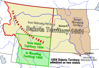
The Pembina Region, also referred to as the Pembina District and Pembina Department, is the historic name of an unorganized territory of land that was ceded to the United States in 1818. The area included the portions of what became the States of Minnesota, North Dakota, and South Dakota lying within the Hudson Bay drainage basin. The area included settlements in the Pembina River area. The region was formerly part of British Rupert's Land, granted by British royal charter to the Hudson's Bay Company. After the Selkirk Concession and establishment of the agricultural Red River Colony in 1812, the area was governed as the District of Assiniboia. The Treaty of 1818 de jure transferred the region south of the 49th parallel to the United States from the British. Settlements south of the boundary continued to be de facto administered as part of Assiniboia until at least 1823.

Akra Township is a township in Pembina County, North Dakota, United States.

The Little Shell Band of Chippewa are a historic sub-band of the Pembina Band of Chippewa Indians led by Chief Little Shell in the nineteenth century. Based in North Dakota around the Pembina River, they are part of the Ojibwe, one of the Anishinaabe peoples, who occupied territory west of the Great Lakes by that time. Many had partial European ancestry from intermarriage by French-Canadian fur traders and trappers. Some began to identify as Métis, today recognized as one of the Indigenous Peoples of Canada. Located in the 17th century in the areas around the Great Lakes, they gradually moved west into North Dakota and Montana.

The Pembina Band of Chippewa Indians is a historical band of Chippewa (Ojibwe), originally living along the Red River of the North and its tributaries. Through the treaty process with the United States, the Pembina Band was settled on reservations in Minnesota and North Dakota. Some tribal members refusing settlement in North Dakota relocated northward and westward, some eventually settling in Montana. The traditional tribal leadership of Little Shell of The Pembina Band departed from The Turtle Mountain Band of Chippewa Indians and briefly camped in Dunsieth, ND where the Little Shell Campsite is memorialized, before residing at Spirit Lake, North Dakota, and Wolf Point, Montana.

<span class="mw-page-title-main">Turtle Mountain (plateau)</span> Plateau on the US-Canadian border

Turtle Mountain, or the Turtle Mountains, is an area in central North America, in the north-central portion of the U.S. state of North Dakota and southwestern portion of the Canadian province of Manitoba, approximately 62 miles (100 km) south of the city of Brandon on Manitoba Highway 10 / U.S. Route 281. It is a plateau 2,000 ft above sea level, 300 ft to 400 ft above the surrounding countryside, extending 20 mi (32 km) from north to south and 40 mi (64 km) from east to west. Rising 1,031 feet (314 m), North Dakota's most prominent peak, Boundary Butte, is located at the western edge of the plateau.

<span class="mw-page-title-main">Porter J. McCumber</span> American politician (1858–1933)

Porter James McCumber was a United States senator from North Dakota. He was a supporter of the 1906 "Pure Food and Drug Act", and of the League of Nations.

<span class="mw-page-title-main">Treaty of Old Crossing</span>

The Pembina and Red Lake bands of Chippewa ceded to the United States the Red River Valley of the north in two treaties. Both were named for the treaty site, "Old Crossing" and the year, Treaty of Old Crossing (1863) and the Treaty of Old Crossing (1864). In Minnesota, the ceded territory included all land west of a line running generally southwest from the Lake of the Woods to Thief Lake, about 30 miles (48 km) west of Red Lake, and then angling southeast to the headwaters of the Wild Rice River near the divide separating the watersheds of the Red River of the North and the Mississippi River. In North Dakota, the ceded territory was all of the Red River Valley north of the Sheyenne River. In size, the area was roughly 127 miles (204 km) east-west and 188 miles (303 km) north-south, making it nearly 11,000,000 acres (45,000 km2) of prairie and forest.

<span class="mw-page-title-main">Little Shell Tribe of Chippewa Indians of Montana</span> Little Shell Tribe of Chippewa Indians of Montana

Little Shell Tribe of Chippewa Indians of Montana is a federally recognized tribe of Ojibwe, Métis, and Cree people in Montana. The name of the tribe is often shortened to Little Shell. The current population of enrolled tribal members is approximately 6,600. They have a 35,000-sq. foot office complex in Great Falls.

Thingvalla Township is a township in Pembina County, North Dakota, United States. The 2000 census reported a population of 121, and an estimated population of 103 as of 2009. President Ólafur Grímsson of Iceland visited the area in 1999 to dedicate a monument to poet K. N. Julius at Thingvalla Church, and Prime Minister Geir Haarde visited in 2007 to dedicate a memorial to the church, which burned to the ground in 2003.

<span class="mw-page-title-main">Georges-Antoine Belcourt</span> French Canadian priest and missionary

Georges-Antoine Belcourt, also George Antoine Bellecourt, was a French Canadian Roman Catholic diocesan priest and missionary. Born in Baie-du-Febvre, Quebec, Belcourt was ordained in 1827. He established missions in areas of Quebec and Manitoba. On the frontier, he became involved in a political dispute between the local First Nations population and the Hudson's Bay Company, the monopoly fur trading company.

<span class="mw-page-title-main">Renwick Dam</span> Reservoir in North Dakota, United States

Renwick Dam is a dam in Akra Township, Pembina County, North Dakota, USA, in the northeastern corner of the state.

References

  1. 1 2 "State & County QuickFacts". United States Census Bureau. Retrieved April 3, 2023.
  2. "Find a County". National Association of Counties. Retrieved June 7, 2011.
  3. About US: "Move to the Plains" Archived March 10, 2011, at the Wayback Machine , Turtle Mountain Band of Chippewa Indians, accessed June 27, 2011
  4. Ojibwe People's Dictionary [ permanent dead link ], University of Minnesota
  5. Wick, Douglas A. (1988). North Dakota Place Names. Bismarck ND: Hedemarken Collectibles. ISBN   0-9620968-0-6. OCLC   191277027.
  6. "County History". North Dakota.gov. The State of North Dakota. Archived from the original on February 2, 2015. Retrieved February 4, 2015.
  7. Long, John H. (2006). "Dakota Territory, South Dakota, and North Dakota: Individual County Chronologies". Dakota Territory Atlas of Historical County Boundaries. The Newberry Library. Archived from the original on November 11, 2007. Retrieved February 26, 2019.
  8. Johnson, Sveinbjorn (1906). Libby, Orin Grant (ed.). The Icelandic Settlement of Pembina County. Collections of the State Historical Society of North Dakota. Vol. 1. Bismarck ND: Tribune, State Printers and Binders. pp. 89–130. OCLC   01773487.
  9. Williams, Mary Ann (Barnes) (1966). Origins of North Dakota Place Names. Bismarck ND: Bismarck Tribune, 1966. OCLC   431626.
  10. North Dakota Secretary of State (1989). North Dakota Centennial Blue Book. Bismarck, ND: North Dakota Legislative Assembly. p. 539.
  11. 1 2 Pembina County ND Google Maps (accessed February 26, 2019)
  12. ""Find an Altitude/Pembina County ND" Google Maps (accessed February 26, 2019)". Archived from the original on May 21, 2019. Retrieved February 27, 2019.
  13. "2010 Census Gazetteer Files". United States Census Bureau. August 22, 2012. Archived from the original on January 29, 2015. Retrieved February 1, 2015.
  14. "Annual Estimates of the Resident Population for Counties: April 1, 2020 to July 1, 2022" . Retrieved April 3, 2023.
  15. "U.S. Decennial Census". United States Census Bureau. Retrieved February 1, 2015.
  16. "Historical Census Browser". University of Virginia Library. Retrieved February 1, 2015.
  17. Forstall, Richard L., ed. (April 20, 1995). "Population of Counties by Decennial Census: 1900 to 1990". United States Census Bureau. Retrieved February 1, 2015.
  18. "Census 2000 PHC-T-4. Ranking Tables for Counties: 1990 and 2000" (PDF). United States Census Bureau. April 2, 2001. Archived (PDF) from the original on March 27, 2010. Retrieved February 1, 2015.
  19. Leip, David. "Atlas of US Presidential Elections". uselectionatlas.org. Retrieved April 13, 2018.

48°46′N97°33′W / 48.77°N 97.55°W / 48.77; -97.55