Bottineau County, North Dakota

Last updated

Bottineau County
Customs house in Antler, North Dakota, alternate view.jpg
Map of North Dakota highlighting Bottineau County.svg
Location within the U.S. state of North Dakota
North Dakota in United States.svg
North Dakota's location within the U.S.
Coordinates: 48°47′N100°50′W / 48.79°N 100.84°W / 48.79; -100.84
CountryFlag of the United States.svg United States
StateFlag of North Dakota.svg  North Dakota
FoundedJanuary 4, 1873 (created)
July 17, 1884 (organized)
Named for Pierre Bottineau
Seat Bottineau
Largest cityBottineau
Area
  Total1,697 sq mi (4,400 km2)
  Land1,668 sq mi (4,320 km2)
  Water29 sq mi (80 km2)  1.7%
Population
 (2020)
  Total6,379
  Estimate 
(2022)
6,376 Decrease2.svg
  Density3.8/sq mi (1.5/km2)
Time zone UTC−6 (Central)
  Summer (DST) UTC−5 (CDT)
Congressional district At-large
Website www.bottineauco.com

Bottineau County is a county in the U.S. state of North Dakota. As of the 2020 census, the population was 6,379. [1] Its county seat is Bottineau. [2]

Contents

The Territorial legislature identified Bottineau as one of the original counties of the territory. on January 4, 1873. Its organization was effected on July 17, 1884. [3] It is named for Pierre Bottineau (c.1814-1895), a Métis pioneer, hunter, and trapper who became a successful land speculator. [4]

Bottineau is well known for its winter park, snowmobiling, and ice fishing. It is south of the Canadian borders of Manitoba and Saskatchewan.

Geography

Soils of Bottineau County Bottineau Co ND Pie Chart 3-5-17 No Text.pdf
Soils of Bottineau County

Bottineau County lies on the north side of North Dakota. Its north boundary line abuts the south boundary line of Canada. The Deep River flows south-southeastward through the center part of the county. The county terrain consists of rolling hills, dotted with lakes and ponds. [5] The terrain slopes to the south, with its highest point on its upper east boundary line, at 2,283 ft (696 m) ASL. [6] The county has a total area of 1,697 square miles (4,400 km2), of which 1,668 square miles (4,320 km2) is land and 29 square miles (75 km2) (1.7%) is water. [7]

Part of the Turtle Mountain plateau lies in the northeastern corner of the county.

Adjacent counties and rural municipalities

Major highways

Protected areas

[5]

Lakes

  • Black Lake
  • Boundary Lake
  • Grass Lake
  • Island Lake
  • Long Lake
  • Loon Lake
  • Lords Lake
  • Lake Metigoshe
  • Pelican Lake
  • Strawberry Lake

[5]

Demographics

Historical population
CensusPop.Note
1890 2,893
1900 7,532160.4%
1910 17,295129.6%
1920 15,109−12.6%
1930 14,853−1.7%
1940 13,253−10.8%
1950 12,140−8.4%
1960 11,315−6.8%
1970 9,496−16.1%
1980 9,239−2.7%
1990 8,011−13.3%
2000 7,149−10.8%
2010 6,429−10.1%
2020 6,379−0.8%
2022 (est.)6,376 [8] 0.0%
U.S. Decennial Census [9]
1790-1960 [10] 1900-1990 [11]
1990-2000 [12] 2010-2020 [1]

2020 census

As of the census of 2020, there were 6,379 people.

2010 census

As of the census of 2010, there were 6,429 people, 2,832 households, and 1,823 families in the county. The population density was 3.9 inhabitants per square mile (1.5/km2). There were 4,341 housing units at an average density of 2.6 units per square mile (1.0/km2). The racial makeup of the county was 95.1% white, 2.1% American Indian, 0.4% black or African American, 0.2% Asian, 0.3% from other races, and 1.8% from two or more races. Those of Hispanic or Latino origin made up 1.3% of the population. In terms of ancestry, 47.0% were Norwegian, 37.4% were German, 7.7% were Irish, 6.2% were Swedish, and 1.4% were American.

Of the 2,832 households, 22.8% had children under the age of 18 living with them, 55.3% were married couples living together, 5.6% had a female householder with no husband present, 35.6% were non-families, and 32.2% of all households were made up of individuals. The average household size was 2.17 and the average family size was 2.72. The median age was 48.0 years.

The median income for a household in the county was $40,227 and the median income for a family was $60,714. Males had a median income of $42,227 versus $27,500 for females. The per capita income for the county was $26,277. About 9.5% of families and 13.6% of the population were below the poverty line, including 16.5% of those under age 18 and 13.4% of those age 65 or over.

Population by decade

Bottineau County, North Dakota

Communities

Cities

Unincorporated communities

[5]

Townships

Politics

Bottineau County voters have been reliably Republican for decades. In no national election since 1964 has the county selected the Democratic Party candidate.

United States presidential election results for Bottineau County, North Dakota [13]
Year Republican Democratic Third party
No.%No.%No.%
2020 2,57574.19%82123.65%752.16%
2016 2,49471.38%73621.06%2647.56%
2012 2,28064.14%1,18333.28%922.59%
2008 2,05958.56%1,38739.45%701.99%
2004 2,46867.17%1,16831.79%381.03%
2000 2,34963.66%1,17331.79%1684.55%
1996 1,68247.80%1,28036.37%55715.83%
1992 1,78743.54%1,26630.85%1,05125.61%
1988 2,53059.52%1,68439.61%370.87%
1984 3,35671.59%1,27927.28%531.13%
1980 3,39470.30%1,09022.58%3447.13%
1976 2,63856.13%1,98742.28%751.60%
1972 3,26369.60%1,36929.20%561.19%
1968 2,63360.06%1,52034.67%2315.27%
1964 2,06044.71%2,54655.26%10.02%
1960 3,09261.00%1,97438.94%30.06%
1956 2,92362.91%1,71836.98%50.11%
1952 3,91177.69%1,09421.73%290.58%
1948 2,51359.39%1,57137.13%1473.47%
1944 2,66357.15%1,95341.91%440.94%
1940 3,12955.60%2,46943.87%300.53%
1936 1,22421.18%3,28656.86%1,26921.96%
1932 1,20121.57%4,17875.05%1883.38%
1928 2,68049.79%2,64849.19%551.02%
1924 1,33831.99%2215.28%2,62362.72%
1920 3,48772.52%97020.17%3517.30%
1916 1,29441.34%1,47147.00%36511.66%
1912 70026.94%82531.76%1,07341.30%
1908 1,95159.45%1,14634.92%1855.64%
1904 2,09468.48%75324.62%2116.90%
1900 72852.30%62845.11%362.59%

See also

Related Research Articles

<span class="mw-page-title-main">Spink County, South Dakota</span> County in South Dakota, United States

Spink County is a county in the U.S. state of South Dakota. As of the 2020 census, the population was 6,361. Its county seat is Redfield. The county was created in 1873, and was organized in 1879 within Dakota Territory.

<span class="mw-page-title-main">Roberts County, South Dakota</span> County in South Dakota, United States

Roberts County is a county in the U.S. state of South Dakota. As of the 2020 census, the population was 10,280. Its county seat is Sisseton. The county was named either for S. G. Roberts of Fargo, North Dakota, or for Solomon Robar, an early local French fur trader. It was created on March 8, 1883, and fully organized by August 6 of that year. Its boundary was altered once, in 1885.

<span class="mw-page-title-main">Hand County, South Dakota</span> County in South Dakota, United States

Hand County is a county in the U.S. state of South Dakota. As of the 2020 census, the population was 3,145. Its county seat is Miller.

<span class="mw-page-title-main">Gregory County, South Dakota</span> County in South Dakota, United States

Gregory County is a county in the U.S. state of South Dakota. As of the 2020 census, the population was 3,994. Its county seat is Burke. The county was created in 1862 and organized in 1898. It was named for the politician J. Shaw Gregory.

<span class="mw-page-title-main">Buffalo County, South Dakota</span> County in South Dakota, United States

Buffalo County is a county in the U.S. state of South Dakota. As of the 2020 census, the population was 1,948. Its county seat is Gann Valley which, at 10 people, is the least populous county seat in the United States. The county was created in 1864, and was organized in 1871 as part of the Dakota Territory.

<span class="mw-page-title-main">Ward County, North Dakota</span> County in North Dakota, United States

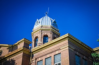
Ward County is a county in the U.S. state of North Dakota. As of the 2020 census, the population was 69,919, making it the fourth most populous county in North Dakota. Its county seat is Minot. Ward County is part of the Minot, ND Micropolitan Statistical Area.

<span class="mw-page-title-main">Walsh County, North Dakota</span> County in North Dakota, United States

Walsh County is a county in the U.S. state of North Dakota. As of the 2020 census, the population was 10,563. Its county seat is Grafton.

<span class="mw-page-title-main">Towner County, North Dakota</span> County in North Dakota, United States

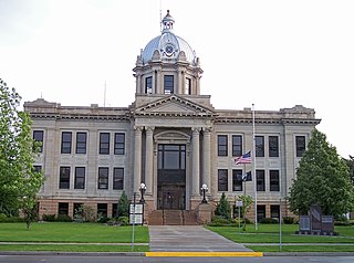
Towner County is a county in the U.S. state of North Dakota. As of the 2020 census, the population is 2,162. Its county seat is Cando. It is south of the Canada–US border with Manitoba.

<span class="mw-page-title-main">Sheridan County, North Dakota</span> County in North Dakota, United States

Sheridan County is a county located in the U.S. state of North Dakota. As of the 2020 census, the population was 1,265, making it the third-least populous county in North Dakota. Its county seat is McClusky.

<span class="mw-page-title-main">Rolette County, North Dakota</span> County in the United States

Rolette County is a county in the U.S. state of North Dakota. As of the 2020 census, the population was 12,187. Its county seat is Rolla.

<span class="mw-page-title-main">Richland County, North Dakota</span> County in North Dakota, United States

Richland County is a county in the far southeast corner of the U.S. state of North Dakota. As of the 2020 census, the population was 16,529. Its county seat is Wahpeton.

<span class="mw-page-title-main">Renville County, North Dakota</span> County in North Dakota, United States

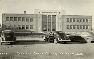
Renville County is a county in the U.S. state of North Dakota. As of the 2020 census, the population was 2,282. Its county seat is Mohall.

<span class="mw-page-title-main">Ramsey County, North Dakota</span> County in North Dakota, United States

Ramsey County is a county in the U.S. state of North Dakota. As of the 2020 census, the population was 11,605. Its county seat is Devils Lake.

<span class="mw-page-title-main">Pierce County, North Dakota</span> County in North Dakota, United States

Pierce County is a county in the U.S. state of North Dakota. As of the 2020 census, the population was 3,990. Its county seat is Rugby.

<span class="mw-page-title-main">McHenry County, North Dakota</span> County in North Dakota, United States

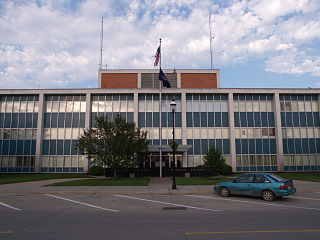
McHenry County is a county in the U.S. state of North Dakota. As of the 2020 census, the population was 5,345. Its county seat is Towner.

<span class="mw-page-title-main">Cavalier County, North Dakota</span> County in North Dakota, United States

Cavalier County is a county in the U.S. state of North Dakota. It is south of the Canada–US border with Manitoba. As of the 2020 census, the population was 3,704. Its county seat is Langdon. The city of Cavalier is in nearby Pembina County.

<span class="mw-page-title-main">Burke County, North Dakota</span> County in North Dakota, United States

Burke County is a county on the north edge of the U.S. state of North Dakota, adjacent to the south line of Canada. As of the 2020 census, the population was 2,201. The county seat is Bowbells. The county is named after John Burke, the tenth Governor of North Dakota.

<span class="mw-page-title-main">Renville County, Minnesota</span> County in Minnesota, United States

Renville County is a county in the U.S. state of Minnesota. As of the 2020 census the population was 14,723. Its county seat is Olivia.

<span class="mw-page-title-main">Mohall, North Dakota</span> City in North Dakota, United States

Mohall is a city in Renville County, North Dakota, United States. It is the county seat of Renville County. The population was 694 at the 2020 census. Mohall is part of the Minot Micropolitan Statistical Area.

<span class="mw-page-title-main">Blaine Township, Bottineau County, North Dakota</span> Township in North Dakota, United States

Blaine Township is a township in Bottineau County in the U.S. state of North Dakota. Its population during the 2000 Census was 30, and an estimated 27 people as of 2009.

References

  1. 1 2 "State & County QuickFacts". United States Census Bureau. Retrieved April 3, 2023.
  2. "Find a County". National Association of Counties. Archived from the original on May 31, 2011. Retrieved June 7, 2011.
  3. "Dakota Territory, South Dakota, and North Dakota: Individual County Chronologies". Dakota Territory Atlas of Historical County Boundaries. The Newberry Library. 2006. Archived from the original on April 2, 2018. Retrieved February 2, 2015.
  4. "County History". Official Portal for North Dakota State Government. Archived from the original on February 2, 2015. Retrieved May 4, 2011.
  5. 1 2 3 4 Bottineau County ND Google Maps (accessed February 14, 2019)
  6. ""Find an Altitude/Bottineau County ND" Google Maps (accessed 14 February 2019)". Archived from the original on May 21, 2019. Retrieved February 15, 2019.
  7. "2010 Census Gazetteer Files". United States Census Bureau. August 22, 2012. Archived from the original on January 29, 2015. Retrieved January 27, 2015.
  8. "Annual Estimates of the Resident Population for Counties: April 1, 2020 to July 1, 2022". Census.gov . Retrieved April 3, 2023.
  9. "U.S. Decennial Census". United States Census Bureau. Retrieved January 27, 2015.
  10. "Historical Census Browser". University of Virginia Library. Retrieved January 27, 2015.
  11. Forstall, Richard L., ed. (March 27, 1995). "Population of Counties by Decennial Census: 1900 to 1990". United States Census Bureau. Retrieved January 27, 2015.
  12. "Census 2000 PHC-T-4. Ranking Tables for Counties: 1990 and 2000" (PDF). United States Census Bureau. April 2, 2001. Archived (PDF) from the original on March 27, 2010. Retrieved January 27, 2015.
  13. Leip, David. "Atlas of US Presidential Elections". uselectionatlas.org. Retrieved April 12, 2018.

48°47′N100°50′W / 48.79°N 100.84°W / 48.79; -100.84