Pickering Township, Bottineau County, North Dakota

Last updated
Pickering Township

Township of Pickering
ND Bottineau County Pickering Township.svg
Location of Pickering Township in Bottineau County
Coordinates: 48°53′00″N100°32′02″W / 48.88333°N 100.53389°W / 48.88333; -100.53389 Coordinates: 48°53′00″N100°32′02″W / 48.88333°N 100.53389°W / 48.88333; -100.53389
Country United States
State North Dakota
County Bottineau
Organizedcirca 1920
Area
  Total35.57 sq mi (92.1 km2)
  Land35.56 sq mi (92.1 km2)
  Water0.01 sq mi (0.03 km2)
Elevation
[3]
1,627 ft (496 m)
Population
  Total193
  Density5.4/sq mi (2.1/km2)
Time zone UTC-6 (Central (CST))
  Summer (DST) UTC-5 (CDT)
Area code 701
FIPS code [2] [4] 38-62300
GNIS feature ID [2] [4] 1759290

Pickering Township is a civil township in Bottineau County in the U.S. state of North Dakota. Its population was 193 as of the 2010 census, [2] down from 213 at the 2000 census. [5]

Contents

History

Pickering Township was organized sometime between 1910 and 1920 from Vinge School Township and the western portion of Bottineau School Township. [6]

Reportedly, in 1883, Norwegian settlers from Polk County, Minnesota, established the first Norwegian settlement in Bottineau County near Carbury in present-day Pickering Township. Other Norwegians followed in 1886. [7]

Geography

Pickering Township is located in Township 162N, Range 76W. [6] [8] North Dakota Highway 14 is a primary highway in the township, and the city of Bottineau, which is the county seat, is located in the southeast corner of the township.

According to the 2010 United States Census, the township has a total area of 35.570 square miles (92.13 km2), of which 35.557 square miles (92.09 km2) is land and 0.013 square miles (0.03 km2) is water. [2]

Carbury Dam is a public fishing area located 1 mile (1.6 km) south and 1 mile (1.6 km) west of Carbury. It is managed by the North Dakota Game and Fish Department. [9]

Related Research Articles

Bottineau County, North Dakota U.S. county in North Dakota

Bottineau County is a county in the U.S. state of North Dakota. As of the 2010 census, the population was 6,579. Its county seat is Bottineau.

Leal, North Dakota City in North Dakota, United States

Leal is a city in Barnes County in the States of North Dakota. The population was 20 at the 2010 census. Leal was founded in 1892. The name comes from the Scots word for "faithful," which in the phrase laund o the leal means Heaven.

Antler, North Dakota City in North Dakota, United States

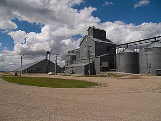
Antler is a city in Bottineau County in the State of North Dakota. The population was 27 at the 2010 census. Antler was founded in 1905.

Landa, North Dakota City in North Dakota, United States

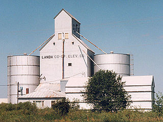
Landa is a city in Bottineau County, North Dakota, United States. The population was 38 at the 2010 census. Landa was founded in 1904.

Omemee, North Dakota Place in North Dakota, United States

Omemee is a ghost town in Bottineau County in the U.S. state of North Dakota. It was a railroad hub in the early 1910s, located at the junction of two major railroads, the Soo Line Railroad and the Great Northern Railway. Incorporated as a city in 1902, Omemee has been abandoned since 2003.

Amity Township, Bottineau County, North Dakota Township in North Dakota, United States

Amity Township is a civil township in Bottineau County in the U.S. state of North Dakota. As of the 2000 census, its population was 35.

Roth, North Dakota Unincorporated community in North Dakota, United States

Roth is an unincorporated community in Bottineau County in the U.S. state of North Dakota. It is located roughly 6 miles (9.7 km) to the west of Souris, North Dakota. Roth does not have a post office, but it shares the same zip code of 58783 with Souris.

Carbury, North Dakota Unincorporated community in North Dakota, United States

Carbury is an unincorporated community in Bottineau County in the U.S. state of North Dakota. It is located along North Dakota Highway 14 in the eastern part of the county, east of Souris, North Dakota. The town is virtually abandoned, and the 2000 Census did not record a population. The post office closed in 1984, and it is now part of zip code 58783 covered by the post office in Souris.

Overly, North Dakota City in North Dakota, United States

Overly is a city in Bottineau County in the State of North Dakota. The population was 18 at the 2010 census.

Cecil Township, Bottineau County, North Dakota Township in North Dakota, United States

Cecil Township is a civil township in Bottineau County in the U.S. state of North Dakota. As of the 2000 census, its population was 28.

Haram Township, Bottineau County, North Dakota Township in North Dakota, United States

Haram Township is a civil township in Bottineau County in the U.S. state of North Dakota. As of the 2000 census, its population was 85.

Captain's Landing Township is a township in Morton County, North Dakota, United States. Its population as of the 2000 Census was 153. It is located east of Mandan, North Dakota along the Missouri River, between Interstate 94 and the Bismarck Expressway.

Sherbrooke Township is a township in Steele County in the U.S. state of North Dakota. Its population as of the 2000 Census was 62, which had dropped to an estimated 46 people as of 2009. The township shares its name with Sherbrooke, North Dakota, which was the county seat from 1885 to 1919.

Finley Township is a township in Steele County in the U.S. state of North Dakota. Its population as of the 2000 Census was 64, which had dropped to an estimated 47 people as of 2009. The county seat of Finley, North Dakota is located in the township and shares its name.

Van Hook Township, Mountrail County, North Dakota Township in North Dakota, United States

Van Hook Township is a township in Mountrail County in the U.S. state of North Dakota. At the time of the 2000 Census, its population was 42, and estimated to be 41 as of 2009.

Bentinck Township, Bottineau County, North Dakota Township in North Dakota, United States

Bentinck Township is a township in Bottineau County in the U.S. state of North Dakota. Its population during the 2000 Census was 32, and an estimated 29 people as of 2009.

Blaine Township, Bottineau County, North Dakota Township in North Dakota, United States

Blaine Township is a township in Bottineau County in the U.S. state of North Dakota. Its population during the 2000 Census was 30, and an estimated 27 people as of 2009.

Beach Township, Golden Valley County, North Dakota Township in North Dakota, United States

Beach Township is a township in Golden Valley County, North Dakota, United States. Its population was 157 as of the 2010 census, down from 189 at the 2000 census.

Baker Township, Randolph County, Arkansas Township in Arkansas, United States

Baker Township is a township in Randolph County, Arkansas, United States. Its total population was 55 as of the 2010 United States Census, an increase of 1.85 percent from 54 at the 2000 census.

Bartholomew Township, Lincoln County, Arkansas Township in Arkansas, United States

Bartholomew Township is a township in Lincoln County, Arkansas, United States. Its total population was 687 as of the 2010 United States Census, a decrease of 19.84 percent from 857 at the 2000 census.

References

  1. U.S. Census Bureau. Census 2000, Summary File 1. "GCT-PH1. Population, Housing Units, Area, and Density: 2000 - County -- Subdivision and Place". American FactFinder. <http://factfinder2.census.gov>. Retrieved 2008-01-31.
  2. 1 2 3 4 5 6 "County Subdivisions: North Dakota". [2010 Census Gazetteer Files]. United States Census Bureau. Archived from the original on June 15, 2013. Retrieved June 29, 2013.
  3. "Feature Detail Report for: Township of Pickering". Geographic Names Information System . United States Geological Survey . Retrieved June 29, 2013.
  4. 1 2 "FIPS55 Data: North Dakota". [FIPS55 Data]. United States Geological Survey. February 23, 2006. Archived from the original on June 18, 2006.
  5. U.S. Census Bureau. Census 2000. "Census Demographic Profiles, Pickering Township" (PDF). CenStats Databases. Retrieved 2009-01-31.[ dead link ]
  6. 1 2 U.S. Census Bureau (1921). "Number and Distribution of Inhabitants, North Dakota" (PDF). Fourteenth Census of the United States: 1920. Government Printing Office . Retrieved 2008-07-20.
  7. Sherman, William C. (1983). Pairie Mosaic: An Ethnic Atlas of Rural North Dakota. Fargo, North Dakota: North Dakota Institute for Regional Studies. p. 71. ISBN   0-911042-27-X. OCLC   256228966.
  8. U.S. Census Bureau (1913). "Number of Inhabitants, North Dakota" (PDF). Thirteenth Census of the United States: 1910. Government Printing Office. p. 324. Retrieved 2008-07-20.
  9. "Carbury Dam, Bottineau County" (PDF). Lake Contour Maps. North Dakota Game and Fish Department. Archived from the original (PDF) on 2009-06-25. Retrieved 2009-08-04.