Burleigh County, North Dakota

Last updated

Burleigh County
Burleigh County Courthouse.jpg
Seal of Burleigh County, North Dakota.png
Map of North Dakota highlighting Burleigh County.svg
Location within the U.S. state of North Dakota
North Dakota in United States.svg
North Dakota's location within the U.S.
Coordinates: 46°59′N100°28′W / 46.98°N 100.47°W / 46.98; -100.47
CountryFlag of the United States.svg United States
StateFlag of North Dakota.svg  North Dakota
FoundedJanuary 4, 1873
Named for Walter A. Burleigh
Seat Bismarck
Largest cityBismarck
Area
  Total1,668 sq mi (4,320 km2)
  Land1,633 sq mi (4,230 km2)
  Water36 sq mi (90 km2)  2.1%
Population
 (2020)
  Total98,458
  Estimate 
(2023)
100,012 Increase2.svg
  Density59/sq mi (23/km2)
Time zone UTC−6 (Central)
  Summer (DST) UTC−5 (CDT)
Congressional district At-large
Website www.burleighco.com

Burleigh County is a county in the U.S. state of North Dakota. As of the 2020 census, the population was 98,458, [1] making it the second most populous county in North Dakota. Its county seat is Bismarck, the state capital. [2] The county was named for Dakota Territory political figure Walter A. Burleigh.

Contents

History

The territorial legislature created Burleigh County on January 4, 1873, annexing territory from Buffalo County. Burleigh was not organized at that time, but the organization was effected on July 16, 1873. Its boundaries were altered in 1879, 1881, 1883, and twice in 1885. [3] [4]

Burleigh County is included in the Bismarck, ND Metropolitan Statistical Area, commonly called "Bismarck–Mandan".

Geography

The Missouri River flows south-southeasterly along the lower west boundary line of Burleigh County. The central part of the county is drained by south-flowing creeks. The county terrain consists of semi-arid low rolling hills, partially devoted to agriculture. [5] The terrain slopes to the south, and its western portion also slopes to the river valley. The terrain's highest point is on the upper portion of the east boundary line, at 2,060 ft (630 m) ASL. [6] The county has a total area of 1,668 square miles (4,320 km2), of which 1,633 square miles (4,230 km2) is land and 36 square miles (93 km2) (2.1%) is water. [7]

Major highways

Transit

Adjacent counties

Protected areas

Lakes

  • Bunce Lake
  • Bunker Lake
  • Clear Lake
  • Florence Lake
  • Grass Lake
  • Harriet Lake
  • Horseshoe Lake
  • Lonetree Lake
  • Long Lake
  • Mitchell Lake
  • New Johns Lake (part)
  • O'Brien Lake
  • Pelican Lake
  • Rice Lake

[5]

Demographics

Historical population
CensusPop.Note
1880 3,246
1890 4,24730.8%
1900 6,08143.2%
1910 13,087115.2%
1920 15,57819.0%
1930 19,76926.9%
1940 22,73615.0%
1950 25,67312.9%
1960 34,01632.5%
1970 40,71419.7%
1980 54,81134.6%
1990 60,1319.7%
2000 69,41615.4%
2010 81,30817.1%
2020 98,45821.1%
2023 (est.)100,012 [8] 1.6%
U.S. Decennial Census [9]
1790-1960 [10] 1900-1990 [11]
1990-2000 [12] 2010-2020 [1]

2020 census

As of the 2020 census, there were 98,458 people, 39,927 households, and 24,822 families in the county. [13] The population density was 60.3 inhabitants per square mile (23.3/km2) There were 42,692 housing units.

2010 census

As of the 2010 census, there were 81,308 people, 33,976 households, and 21,213 families in the county. The population density was 49.8 inhabitants per square mile (19.2/km2). There were 35,754 housing units at an average density of 21.9 per square mile (8.5/km2). The racial makeup of the county was 93.0% white, 4.2% American Indian, 0.6% black or African American, 0.5% Asian, 0.3% from other races, and 1.4% from two or more races. Those of Hispanic or Latino origin made up 1.2% of the population. In terms of ancestry, 61.0% were German, 21.1% were Norwegian, 8.1% were Russian, 6.8% were Irish, and 2.6% were American.

Of the 33,976 households, 29.0% had children under the age of 18 living with them, 50.2% were married couples living together, 8.7% had a female householder with no husband present, 37.6% were non-families, and 30.5% of all households were made up of individuals. The average household size was 2.31 and the average family size was 2.90. The median age was 37.3 years.

The median income for a household in the county was $53,465 and the median income for a family was $71,103. Males had a median income of $44,944 versus $31,943 for females. The per capita income for the county was $28,784. About 6.3% of families and 9.4% of the population were below the poverty line, including 11.6% of those under age 18 and 11.0% of those age 65 or over.

Population by decade

Burleigh County, North Dakota

Communities

Cities

Census-designated places

Unincorporated communities

Townships

  • Apple Creek
  • Boyd
  • Burnt Creek
  • Canfield
  • Christiania
  • Clear Lake
  • Crofte
  • Cromwell
  • Driscoll
  • Ecklund
  • Estherville
  • Florence Lake
  • Francis
  • Ghylin
  • Gibbs
  • Glenview
  • Grass Lake
  • Harriet-Lien
  • Hay Creek
  • Hazel Grove
  • Logan
  • Long Lake
  • McKenzie
  • Menoken
  • Missouri
  • Morton
  • Naughton
  • Painted Woods
  • Richmond
  • Rock Hill
  • Schrunk
  • Sibley Butte
  • Steiber
  • Sterling
  • Taft
  • Telfer
  • Thelma
  • Trygg
  • Wild Rose
  • Wilson
  • Wing

Politics

Burleigh County voters have voted Republican for several decades. With the exception of 1964, no Democratic Party candidate has received even 40 percent of the county's vote after 1940.

United States presidential election results for Burleigh County, North Dakota [14]
Year Republican Democratic Third party
No.%No.%No.%
2020 34,74468.46%14,34828.27%1,6613.27%
2016 32,53267.80%10,88122.68%4,5669.52%
2012 27,95164.42%14,12232.55%1,3143.03%
2008 25,44360.58%15,60037.14%9562.28%
2004 26,57768.47%11,62129.94%6161.59%
2000 22,46765.16%9,84228.54%2,1736.30%
1996 15,46451.74%10,67935.73%3,74712.54%
1992 16,48450.90%8,94027.61%6,96021.49%
1988 18,00061.89%10,76037.00%3241.11%
1984 19,91368.25%8,78130.10%4821.65%
1980 18,43767.94%6,12922.59%2,5719.47%
1976 13,68058.09%9,18839.02%6812.89%
1972 13,90967.38%5,84128.29%8944.33%
1968 10,66164.03%5,13930.87%8495.10%
1964 7,23946.95%8,12052.66%600.39%
1960 9,49262.13%5,76137.71%250.16%
1956 9,19973.79%3,23125.92%370.30%
1952 9,52679.55%2,40020.04%490.41%
1948 5,04959.45%3,11736.70%3273.85%
1944 4,61659.95%3,06139.75%230.30%
1940 5,85857.06%4,35042.37%580.56%
1936 2,44725.17%6,31464.94%9629.89%
1932 2,68731.84%5,62166.61%1311.55%
1928 3,95555.59%3,07643.23%841.18%
1924 3,15253.17%3796.39%2,39740.44%
1920 4,30077.28%94316.95%3215.77%
1916 1,18245.46%1,26748.73%1515.81%
1912 72036.20%60930.62%66033.18%
1908 1,37565.82%66031.59%542.58%
1904 1,34083.23%23714.72%332.05%
1900 67966.44%33933.17%40.39%

Education

School districts include: [15]

K-12:

Elementary:

Former districts:

See also

Related Research Articles

<span class="mw-page-title-main">Williams County, North Dakota</span> County in North Dakota, United States

Williams County is located on the western border of the U.S. state of North Dakota, next to Montana. As of the 2020 census, the population was 40,950. making it the fifth most populous county in North Dakota. Its county seat is Williston.

<span class="mw-page-title-main">Towner County, North Dakota</span> County in North Dakota, United States

Towner County is a county in the U.S. state of North Dakota. As of the 2020 census, the population is 2,162. Its county seat is Cando. It is south of the Canada–US border with Manitoba.

<span class="mw-page-title-main">Steele County, North Dakota</span> County in North Dakota, United States

Steele County is a county in the U.S. state of North Dakota. As of the 2020 census, the population was 1,798, making it the fifth-least populous county in North Dakota. Its county seat since 1919 is Finley.

<span class="mw-page-title-main">Slope County, North Dakota</span> County in North Dakota, United States

Slope County is a county in the U.S. state of North Dakota. As of the 2020 census, the population was 706, making it the least populous county in North Dakota and the 18th-least populous county in the United States. The county seat is Amidon.

<span class="mw-page-title-main">Sioux County, North Dakota</span> County in North Dakota, United States

Sioux County is a county located along the southern border of the U.S. state of North Dakota. As of the 2020 census, the population was 3,898. Its eastern border is the Missouri River and its county seat is Fort Yates.

<span class="mw-page-title-main">Rolette County, North Dakota</span> County in the United States

Rolette County is a county in the U.S. state of North Dakota. As of the 2020 census, the population was 12,187. Its county seat is Rolla.

<span class="mw-page-title-main">Oliver County, North Dakota</span> County in North Dakota, United States

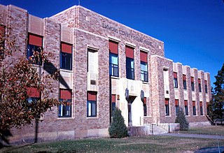
Oliver County is a county located in the U.S. state of North Dakota. As of the 2020 census, the population was 1,877. Its county seat and only city is Center.

<span class="mw-page-title-main">Morton County, North Dakota</span> County in North Dakota, United States

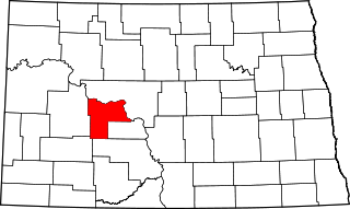
Morton County is a county in the U.S. state of North Dakota. As of the 2020 census, the population was 33,291, making it the sixth most populous county in North Dakota. Its county seat is Mandan. Morton County is included in the Bismarck, ND, Metropolitan Statistical Area.

<span class="mw-page-title-main">Mercer County, North Dakota</span> County in North Dakota, United States

Mercer County is a county in the U.S. state of North Dakota. As of the 2020 census, the population was 8,350. Its county seat is Stanton.

<span class="mw-page-title-main">McLean County, North Dakota</span> County in North Dakota, United States

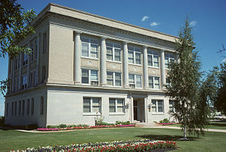
McLean County is a county in the U.S. state of North Dakota. As of the 2020 census, the population was 9,771. Its county seat is Washburn.

<span class="mw-page-title-main">McKenzie County, North Dakota</span> County in North Dakota, United States

McKenzie County is a county in the U.S. state of North Dakota. As of the 2020 census, the population was 14,704. Its county seat is Watford City.

<span class="mw-page-title-main">Emmons County, North Dakota</span> County in North Dakota, United States

Emmons County is a county in the U.S. state of North Dakota. As of the 2020 census, the population was 3,301. Its county seat has been Linton since 1899.

<span class="mw-page-title-main">Barnes County, North Dakota</span> County in North Dakota, United States

Barnes County is a county in the U.S. state of North Dakota. As of the 2020 census, the population was 10,853. Its county seat is Valley City.

<span class="mw-page-title-main">Lincoln, North Dakota</span> City in North Dakota, United States

Lincoln is a city in Burleigh County, North Dakota, United States. It is a suburb of adjacent Bismarck, and also a core city of the Bismarck-Mandan Metropolitan Statistical Area. The population was 4,257 at the 2020 census, making it the 14th most populous city in North Dakota. Lincoln was founded in 1977.

<span class="mw-page-title-main">Regan, North Dakota</span> City in North Dakota, United States

Regan is a city in Burleigh County, North Dakota, United States. Its population was 35 at the 2020 census. Regan was founded in 1912.

<span class="mw-page-title-main">Wing, North Dakota</span> City in North Dakota, United States

Wing is a rural small city in Burleigh County, North Dakota, United States. It is part of the "Bismarck, ND Metropolitan Statistical Area" or "Bismarck-Mandan". The population was 132 at the 2020 census. As of 2010, the town has a post office, a full service station, a bar, a restaurant, a small (10-unit) apartment complex, a senior's center, a hotel, several churches, and a complete (K-12) public school system.

<span class="mw-page-title-main">Devils Lake, North Dakota</span> City in North Dakota, United States

Devils Lake is a city in and the county seat of Ramsey County, North Dakota, United States. The population was 7,192 at the 2020 census. It is named after the nearby body of water called Devils Lake. The first house built by an Euro-American settler was in 1882. It was surveyed in 1883 and named Creelsburg and later Creel City, after the surveyor, Heber M. Creel. In 1884 it was renamed Devils Lake.

<span class="mw-page-title-main">Wilton, North Dakota</span> City in North Dakota, United States

Wilton is a city in Burleigh and McLean counties in North Dakota, United States. It is part of the "Bismarck, ND Metropolitan Statistical Area" or "Bismarck-Mandan". The population was 718 at the 2020 census. Founded in 1899, Wilton was named by General W. D. Washburn after the town of Wilton in his native state of Maine.

<span class="mw-page-title-main">Bismarck metropolitan area</span> Metropolitan area in North Dakota, US

Bismarck–Mandan, colloquially referred to as BisMan, is the metropolitan area composed of Burleigh, Morton, and Oliver counties in the state of North Dakota.

<span class="mw-page-title-main">Menoken, North Dakota</span> Census-designated place in North Dakota, United States

Menoken is an unincorporated community and a census-designated place (CDP) in southwestern Burleigh County, North Dakota, United States. It was designated as part of the U.S. Census Bureau's Participant Statistical Areas Program on June 10, 2010. It was not counted separately during the 2000 Census, but was included in the 2010 Census, where a population of 70 was reported.

References

  1. 1 2 "State & County QuickFacts". United States Census Bureau. Retrieved March 18, 2024.
  2. "Find a County". National Association of Counties. Archived from the original on May 31, 2011. Retrieved June 7, 2011.
  3. "Dakota Territory, South Dakota, and North Dakota: Individual County Chronologies". Dakota Territory Atlas of Historical County Boundaries. The Newberry Library. 2006. Archived from the original on April 2, 2018. Retrieved February 2, 2015.
  4. "County History". North Dakota.gov. The State of North Dakota. Archived from the original on February 2, 2015. Retrieved February 2, 2015.
  5. 1 2 Burleigh County ND Google Maps (accessed February 16, 2019)
  6. ""Find an Altitude/Burleigh County" Google Maps (accessed February 16, 2019)". Archived from the original on May 21, 2019. Retrieved February 16, 2019.
  7. "2010 Census Gazetteer Files". United States Census Bureau. August 22, 2012. Archived from the original on January 29, 2015. Retrieved January 27, 2015.
  8. "Annual Estimates of the Resident Population for Counties: April 1, 2020 to July 1, 2023" . Retrieved March 18, 2024.
  9. "US Decennial Census". United States Census Bureau. Retrieved April 10, 2016.
  10. "Historical Census Browser". University of Virginia Library. Retrieved January 27, 2015.
  11. Forstall, Richard L., ed. (March 27, 1995). "Population of Counties by Decennial Census: 1900 to 1990". US Census Bureau. Retrieved January 27, 2015.
  12. "Census 2000 PHC-T-4. Ranking Tables for Counties: 1990 and 2000" (PDF). United States Census Bureau. April 2, 2001. Archived (PDF) from the original on March 27, 2010. Retrieved January 27, 2015.
  13. "US Census Bureau, Table P16: Household Type". United States Census Bureau. Retrieved March 18, 2024.
  14. Leip, David. "Atlas of US Presidential Elections". uselectionatlas.org. Retrieved April 12, 2018.
  15. "2020 CENSUS - SCHOOL DISTRICT REFERENCE MAP: Burleigh County, ND" (PDF). United States Census Bureau. Archived (PDF) from the original on August 13, 2021. Retrieved July 24, 2022. - Text list
  16. "SCHOOL DISTRICT REFERENCE MAP (2010 CENSUS): Burleigh County, ND" (PDF). United States Census Bureau. Archived (PDF) from the original on July 24, 2022. Retrieved July 24, 2022. - 2010 text list

46°59′N100°28′W / 46.98°N 100.47°W / 46.98; -100.47