Oakes, North Dakota

Last updated

Oakes
Klein and Sutmar Block.jpg
The Klein and Sutmar Block on Main Avenue in Oakes
ND Dickey County Oakes.svg
Location of Oakes, North Dakota
Coordinates: 46°08′23″N98°05′14″W / 46.13972°N 98.08722°W / 46.13972; -98.08722
CountryUnited States
State North Dakota
County Dickey
Founded1886
Government
   Mayor Nathan O'Brien
Area
[1]
  Total1.56 sq mi (4.05 km2)
  Land1.56 sq mi (4.05 km2)
  Water0.00 sq mi (0.00 km2)
Elevation
[2]
1,312 ft (400 m)
Population
 (2020) [3]
  Total1,798
  Estimate 
(2022) [4]
1,767
  Density1,149.62/sq mi (443.73/km2)
Time zone UTC-6 (Central (CST))
  Summer (DST) UTC-5 (CDT)
ZIP code
58474
Area code 701
FIPS code 38-58740
GNIS feature ID1036205 [2]
Highways ND 1
Website oakesnd.com

Oakes is the most populous city in Dickey County, North Dakota, United States. The population was 1,798 at the 2020 census. [3] Oakes was founded in 1886.

Contents

History

Oakes was laid out in 1886. [5] It was named for Thomas F. Oakes, a railroad official. [5] A post office has been in operation in Oakes since 1886. [6] The city was incorporated in 1888. [7]

Geography

Oakes sits approximately one mile east of the James river and is the meeting place of several rail lines. Because of its rail access, Oakes is home to several major grain elevators that handle large volumes of grain, primarily corn.

According to the United States Census Bureau, the city has a total area of 1.56 square miles (4.04 km2), all land. [8]

Demographics

Historical population
CensusPop.Note
1890 379
1900 66876.3%
1910 1,499124.4%
1920 1,6379.2%
1930 1,7094.4%
1940 1,665−2.6%
1950 1,7746.5%
1960 1,650−7.0%
1970 1,7425.6%
1980 2,11221.2%
1990 1,775−16.0%
2000 1,97911.5%
2010 1,856−6.2%
2020 1,798−3.1%
2022 (est.)1,767 [4] −1.7%
U.S. Decennial Census [9]
2020 Census [3]

2020 census

Oakes racial composition
RaceNumberPercent
White 1,65091.77%
Black or African American 60.33%
Native American 60.33%
Asian 120.67%
Pacific Islander 00.0%
Other/Mixed 1246.9%
Hispanic or Latino 1196.62%

As of the census of 2020, there were 1,798 people, 849 households, and 510 families living in the city. The population density was 1,152.56 inhabitants per square mile (445.01/km2). There were 875 housing units at an average density of 580.9 units per square mile (216.56/km2).

2010 census

As of the census of 2010, there were 1,856 people, 807 households, and 476 families living in the city. The population density was 1,131.7 inhabitants per square mile (437.0/km2). There were 912 housing units at an average density of 556.1 per square mile (214.7/km2). The racial makeup of the city was 96.1% White, 0.5% African American, 0.3% Native American, 0.8% Asian, 1.1% from other races, and 1.3% from two or more races. Hispanic or Latino of any race were 3.8% of the population.

There were 807 households, of which 26.8% had children under the age of 18 living with them, 51.2% were married couples living together, 4.5% had a female householder with no husband present, 3.3% had a male householder with no wife present, and 41.0% were non-families. 36.9% of all households were made up of individuals, and 19.4% had someone living alone who was 65 years of age or older. The average household size was 2.19 and the average family size was 2.89.

The median age in the city was 45.7 years. 23% of residents were under the age of 18; 6% were between the ages of 18 and 24; 20.2% were from 25 to 44; 26.7% were from 45 to 64; and 24.1% were 65 years of age or older. The gender makeup of the city was 48.1% male and 51.9% female.

2000 census

As of the census of 2000, there were 1,979 people, 828 households, and 495 families living in the city. The population density was 1,203.0 inhabitants per square mile (464.5/km2). There were 908 housing units at an average density of 552.0 per square mile (213.1/km2). The racial makeup of the city was 97.27% White, 0.20% Native American, 1.01% Asian, 1.01% from other races, and 0.51% from two or more races. Hispanic or Latino of any race were 2.58% of the population.

There were 828 households, out of which 27.7% had children under the age of 18 living with them, 51.2% were married couples living together, 5.2% had a female householder with no husband present, and 40.2% were non-families. 36.7% of all households were made up of individuals, and 20.0% had someone living alone who was 65 years of age or older. The average household size was 2.28 and the average family size was 3.02.

In the city, the population was spread out, with 24.8% under the age of 18, 6.6% from 18 to 24, 23.0% from 25 to 44, 21.0% from 45 to 64, and 24.5% who were 65 years of age or older. The median age was 42 years. For every 100 females, there were 93.5 males. For every 100 females age 18 and over, there were 87.2 males.

The median income for a household in the city was $30,263, and the median income for a family was $39,625. Males had a median income of $29,135 versus $15,611 for females. The per capita income for the city was $17,138. About 6.3% of families and 8.8% of the population were below the poverty line, including 10.4% of those under age 18 and 11.0% of those age 65 or over.

Education

Oakes has two schools, including Oakes Public School and Oakes High School. Oakes Public School provides pre-school and grades K–6. Oakes High School provides grades 7–12. The athletic teams of Oakes High School are called the Tornadoes, replacing the old name the Golden Tornadoes. The current school colors are orange, black, and white.

Notable people

Local media

AM Radio

AM radio stations
FrequencyCall signNameFormatOwnerCity
1220 AM KDDR Full Service (radio format)/Country i3G MediaOakes

FM Radio

FM radio stations
FrequencyCall signNameFormatOwnerCity
95.9 FM KDDR KDDR Full Service (radio format)/Country i3G MediaOakes

Parks

J. Paul Klinger Park

J. Paul Klinger Park is located just southwest of the pool. The park has a roofed shelter with seating and tables. Klinger Park also has a beach volleyball court a picnic area, and a playground that includes a slide, swings, tire swing, tunnel tubes, rock wall, and a rope wall.

Softball Complex

The Oakes softball complex has three softball diamonds, a playground, a two-hole Frisbee golf course, and a concessions stand.

Climate

This climatic region is typified by large seasonal temperature differences, with warm to hot (and often humid) summers and cold (sometimes severely cold) winters. According to the Köppen Climate Classification system, Oakes has a humid continental climate, abbreviated "Dfb" on climate maps. [10]

Related Research Articles

<span class="mw-page-title-main">Dakota City, Iowa</span> City in Iowa, United States

Dakota City is a city in and the county seat of Humboldt County, Iowa, United States. The population was 759 at the time of the 2020 census. Dakota City shares its western border with the much larger city of Humboldt. It is the least populous county seat in Iowa.

<span class="mw-page-title-main">Knox, North Dakota</span> City in North Dakota, United States

Knox is a city in Benson County, North Dakota, United States. The population was 22 at the 2020 census. Knox was founded in 1887.

<span class="mw-page-title-main">Oberon, North Dakota</span> City in North Dakota, United States

Oberon is a city in Benson County, North Dakota, United States. The population was 101 at the 2020 census. Oberon was founded in 1886.

<span class="mw-page-title-main">Warwick, North Dakota</span> City in North Dakota, United States

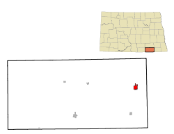
Warwick is a city in Benson County, North Dakota, United States. The population was 55 at the 2020 census. Warwick was founded in 1907.

<span class="mw-page-title-main">Buffalo, North Dakota</span> City in North Dakota, United States

Buffalo is a city in Cass County, North Dakota, United States. The population was 195 at the 2020 census. Buffalo was founded in 1878.

<span class="mw-page-title-main">Plaza, North Dakota</span> City in North Dakota, United States

Plaza is a city in Mountrail County, North Dakota, United States. The population was 211 at the 2020 census. Plaza was founded in 1906. The business district is built around a central town square, city park or "plaza". A key feature of the plaza is a recently completed large covered gazebo.

<span class="mw-page-title-main">Hope, North Dakota</span> City in North Dakota, United States

Hope is a city in Steele County, North Dakota, United States. The population was 272 at the 2020 census. Hope was founded in 1881.

<span class="mw-page-title-main">Pisek, North Dakota</span> City in North Dakota, United States

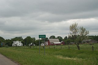
Pisek is a city in Walsh County, North Dakota, United States. The population was 89 at the 2020 census.

<span class="mw-page-title-main">Ryder, North Dakota</span> City in North Dakota, United States

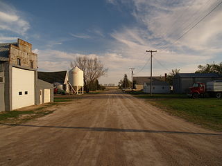
Ryder is a city in Ward County, North Dakota, United States. The population was 108 at the 2020 census. It is part of the Minot Micropolitan Statistical Area. Ryder was founded in 1906.

<span class="mw-page-title-main">Springbrook, North Dakota</span> City in North Dakota, United States

Springbrook is a city in Williams County, North Dakota, United States. The population was 37 at the 2020 census. It is also spelled Spring Brook.

<span class="mw-page-title-main">Groton, South Dakota</span> City in South Dakota, United States

Groton is a city in southeastern Brown County, South Dakota, United States. The population was 1,380 at the 2020 census.

<span class="mw-page-title-main">Parkston, South Dakota</span> City in South Dakota, United States

Parkston is a city in Hutchinson County, South Dakota, United States. The population was 1,567 at the 2020 census.

<span class="mw-page-title-main">Lennox, South Dakota</span> City in South Dakota, United States

Lennox is a city in Lincoln County, South Dakota, United States, located 20 miles (32 km) southwest of Sioux Falls. The population was 2,423 at the 2020 census.

<span class="mw-page-title-main">Tea, South Dakota</span> City in South Dakota, United States

Tea is a city in Lincoln County, South Dakota, United States and is a suburb of Sioux Falls. The population was 5,598 at the 2020 census.

<span class="mw-page-title-main">Presho, South Dakota</span> City in South Dakota, United States

Presho is a small city in Lyman County, South Dakota, United States. The population was 472 at the 2020 census.

<span class="mw-page-title-main">Leola, South Dakota</span> City in South Dakota, United States

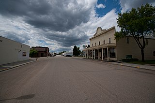
Leola is a small city in, and the county seat of, McPherson County, South Dakota, United States. It was founded on May 1, 1884, and named for Leola Haynes, daughter of one of the town's founders. The population was 434 as of the 2020 census.

<span class="mw-page-title-main">Crooks, South Dakota</span> City in South Dakota, United States

Crooks is a city in Minnehaha County, South Dakota, United States and is a suburb of Sioux Falls. The population was 1,362 at the 2020 census. Crooks was named New Hope until 1904. The town's present name honors W. A. Crooks, a local politician.

<span class="mw-page-title-main">Garretson, South Dakota</span> City in South Dakota, United States

Garretson is a city in Minnehaha County, South Dakota, United States. The city had a population of 1,228 at the 2020 census.

<span class="mw-page-title-main">Hartford, South Dakota</span> City in South Dakota, United States

Hartford is a suburban American city in Minnehaha County, South Dakota, a few miles northwest of Sioux Falls. Its population was 3,354 at the 2020 census.

<span class="mw-page-title-main">Hurley, South Dakota</span> City in South Dakota, United States

Hurley is a city in Turner County, South Dakota, United States. The population was 379 at the 2020 census.

References

  1. "ArcGIS REST Services Directory". United States Census Bureau. Retrieved September 20, 2022.
  2. 1 2 U.S. Geological Survey Geographic Names Information System: Oakes, North Dakota
  3. 1 2 3 "Explore Census Data". United States Census Bureau . Retrieved October 19, 2023.
  4. 1 2 "City and Town Population Totals: 2020-2022". United States Census Bureau. October 19, 2023. Retrieved October 19, 2023.
  5. 1 2 Chicago and North Western Railway Company (1908). A History of the Origin of the Place Names Connected with the Chicago & North Western and Chicago, St. Paul, Minneapolis & Omaha Railways. p. 109.
  6. "Dickey County". Jim Forte Postal History. Retrieved March 23, 2015.
  7. Federal Writers' Project (1938). North Dakota, a Guide to the Northern Prairie State. WPA. p. 307. ISBN   978-1-62376-033-5.
  8. "2021 U.S. Gazetteer Files". United States Census Bureau. Retrieved April 30, 2022.
  9. United States Census Bureau. "Census of Population and Housing" . Retrieved January 30, 2014.
  10. Climate Summary for Oakes, North Dakota