Stanley, North Dakota

Last updated

Stanley, North Dakota
Stanley North Dakota Downtown Looking north ND8.jpg
Downtown Stanley on ND 8
Nickname: 
“Blue Jays”
ND Mountrail County Stanley.svg
Location of Stanley, North Dakota
Coordinates: 48°18′49″N102°23′50″W / 48.31361°N 102.39722°W / 48.31361; -102.39722
CountryUnited States
State North Dakota
County Mountrail
Founded1902
Government
   Mayor Gary Weisenberger
Area
[1]
  Total4.71 sq mi (12.19 km2)
  Land4.51 sq mi (11.67 km2)
  Water0.20 sq mi (0.51 km2)
Elevation
[2]
2,244 ft (684 m)
Population
 (2020) [3]
  Total2,321
  Estimate 
(2022) [4]
2,194
  Density514.98/sq mi (198.84/km2)
Time zone UTC-6 (Central (CST))
  Summer (DST) UTC-5 (CDT)
ZIP code
58784
Area code 701
FIPS code 38-75380
GNIS feature ID1036284 [2]
Highways US 2, ND 8
Website stanleynd.com

Stanley is a city in Mountrail County, North Dakota, United States. It is the county seat of Mountrail County. [5] The population was 2,321 at the 2020 census, [3] making it the 22nd largest city in North Dakota. Stanley was founded in 1902. The town's economy is heavily connected to the nearby oil-rich Bakken Formation.

Contents

History

Stanley was platted in 1902. [6] The Mountrail County Courthouse was built in 1914.

Geography

According to the United States Census Bureau, the city has a total area of 1.83 square miles (4.74 km2), of which 1.82 square miles (4.71 km2) is land and 0.01 square miles (0.03 km2) is water. [7]

Transportation

Rail

Amtrak, the national passenger rail system, serves a station in Stanley via its Empire Builder , a once-daily train in each direction between Portland, Oregon/Seattle, Washington and Chicago. The Great Northern Railway Underpass is now on the National Register of Historic Places.

Economy

Oil

Stanley is situated on the Bakken Formation, which encompasses northwestern North Dakota, northeastern Montana, and southern Saskatchewan, Canada. The formation is a rich source of oil, first discovered in the 1950s. Until the late 2000s the cost of oil extraction was too high to retrieve the oil profitably. With new technologies in oilfield production and the rising price of oil, the field has now become economically viable. The field may be the largest producing onshore field in the Continental United States outside of Texas and California, with the U.S. Geological Survey estimating that it contains between 3 billion and 4,300,000,000 barrels (680,000,000 m3) of oil, sixth overall in the lower 48, and could hold as much as 200 billion barrels (32×10^9 m3) of oil. [8]

Demographics

Historical population
CensusPop.Note
1910 518
1920 59114.1%
1930 93658.4%
1940 1,05813.0%
1950 1,48640.5%
1960 1,79520.8%
1970 1,581−11.9%
1980 1,6313.2%
1990 1,371−15.9%
2000 1,279−6.7%
2010 1,45814.0%
2020 2,32159.2%
2022 (est.)2,194 [4] −5.5%
U.S. Decennial Census [9]
2020 Census [3]

2010 census

As of the census of 2010, there were 1,458 people, 629 households, and 362 families living in the city. The population density was 801.1 inhabitants per square mile (309.3/km2). There were 718 housing units at an average density of 394.5 per square mile (152.3/km2). The racial makeup of the city was 97.4% White, 0.2% African American, 0.5% Native American, 0.5% Asian, 0.6% from other races, and 0.8% from two or more races. Hispanic or Latino of any race were 3.9% of the population.

There were 629 households, of which 24.0% had children under the age of 18 living with them, 47.5% were married couples living together, 5.7% had a female householder with no husband present, 4.3% had a male householder with no wife present, and 42.4% were non-families. 35.8% of all households were made up of individuals, and 16.5% had someone living alone who was 65 years of age or older. The average household size was 2.21 and the average family size was 2.89.

The median age in the city was 44.1 years. 21% of residents were under the age of 18; 6.5% were between the ages of 18 and 24; 23.2% were from 25 to 44; 26.5% were from 45 to 64; and 22.9% were 65 years of age or older. The gender makeup of the city was 50.2% male and 49.8% female.

2000 census

As of the census of 2000, there were 1,279 people, 576 households, and 332 families living in the city. The population density was 740.3 inhabitants per square mile (285.8/km2). There were 664 housing units at an average density of 384.3 per square mile (148.4/km2). The racial makeup of the city was 98.98% White, 0.55% Native American, 0.31% Asian, 0.08% Pacific Islander, and 0.08% from two or more races. Hispanic or Latino of any race were 0.55% of the population.

There were 576 households, out of which 24.0% had children under the age of 18 living with them, 48.1% were married couples living together, 6.8% had a female householder with no husband present, and 42.2% were non-families. 39.8% of all households were made up of individuals, and 24.0% had someone living alone who was 65 years of age or older. The average household size was 2.12 and the average family size was 2.84.

In the city, the population was spread out, with 22.3% under the age of 18, 5.9% from 18 to 24, 18.8% from 25 to 44, 22.8% from 45 to 64, and 30.3% who were 65 years of age or older. The median age was 47 years. For every 100 females, there were 86.2 males. For every 100 females age 18 and over, there were 82.7 males.

The median income for a household in the city was $23,993, and the median income for a family was $35,074. Males had a median income of $26,250 versus $17,813 for females. The per capita income for the city was $15,349. About 5.7% of families and 10.7% of the population were below the poverty line, including 12.6% of those under age 18 and 14.3% of those age 65 or over.

Notable people

Climate

This climatic region is typified by large seasonal temperature differences, with warm to hot (and often humid) summers and cold (sometimes severely cold) winters. According to the Köppen Climate Classification system, Stanley has a humid continental climate, abbreviated "Dfb" on climate maps. [14]

Climate data for Stanley 3 NNW, North Dakota, 1991–2020 normals, 1938-2020 extremes: 2280ft (695m)
MonthJanFebMarAprMayJunJulAugSepOctNovDecYear
Record high °F (°C)56
(13)
60
(16)
76
(24)
90
(32)
95
(35)
102
(39)
105
(41)
110
(43)
100
(38)
92
(33)
74
(23)
64
(18)
110
(43)
Mean maximum °F (°C)41.0
(5.0)
42.7
(5.9)
58.7
(14.8)
76.3
(24.6)
84.9
(29.4)
89.0
(31.7)
92.8
(33.8)
95.7
(35.4)
91.3
(32.9)
78.1
(25.6)
56.8
(13.8)
42.2
(5.7)
95.0
(35.0)
Mean daily maximum °F (°C)17.3
(−8.2)
21.5
(−5.8)
34.2
(1.2)
51.4
(10.8)
64.4
(18.0)
73.1
(22.8)
79.7
(26.5)
80.3
(26.8)
69.6
(20.9)
52.8
(11.6)
34.8
(1.6)
22.2
(−5.4)
50.1
(10.1)
Daily mean °F (°C)8.4
(−13.1)
12.0
(−11.1)
24.1
(−4.4)
38.9
(3.8)
51.2
(10.7)
61.0
(16.1)
66.8
(19.3)
66.0
(18.9)
55.9
(13.3)
41.1
(5.1)
25.6
(−3.6)
13.7
(−10.2)
38.7
(3.7)
Mean daily minimum °F (°C)−0.6
(−18.1)
2.5
(−16.4)
14.0
(−10.0)
26.4
(−3.1)
38.1
(3.4)
49.0
(9.4)
53.9
(12.2)
51.7
(10.9)
42.1
(5.6)
29.4
(−1.4)
16.3
(−8.7)
5.2
(−14.9)
27.3
(−2.6)
Mean minimum °F (°C)−25.0
(−31.7)
−19.6
(−28.7)
−9.9
(−23.3)
11.7
(−11.3)
25.3
(−3.7)
39.3
(4.1)
44.8
(7.1)
42.2
(5.7)
28.2
(−2.1)
14.3
(−9.8)
−3.7
(−19.8)
−18.8
(−28.2)
−27.9
(−33.3)
Record low °F (°C)−41
(−41)
−42
(−41)
−32
(−36)
−15
(−26)
12
(−11)
30
(−1)
34
(1)
30
(−1)
10
(−12)
−3
(−19)
−30
(−34)
−47
(−44)
−47
(−44)
Average precipitation inches (mm)0.54
(14)
0.55
(14)
0.79
(20)
1.33
(34)
2.49
(63)
3.86
(98)
3.09
(78)
2.14
(54)
1.82
(46)
1.31
(33)
0.73
(19)
0.63
(16)
19.28
(489)
Average snowfall inches (cm)7.60
(19.3)
7.10
(18.0)
7.50
(19.1)
4.60
(11.7)
1.30
(3.3)
0.00
(0.00)
0.00
(0.00)
0.00
(0.00)
0.20
(0.51)
3.80
(9.7)
5.10
(13.0)
10.20
(25.9)
47.4
(120.51)
Source 1: NOAA [15]
Source 2: XMACIS (temp records & monthly max/mins) [16]

Related Research Articles

<span class="mw-page-title-main">Mountrail County, North Dakota</span> County in North Dakota, United States

Mountrail County is a county in the northwestern part of North Dakota, United States. As of the 2020 census, the population was 9,809. Its county seat is Stanley. The county was originally created in 1873, then removed in 1892, annexed by Ward County. It was re-created and organized in 1909.

<span class="mw-page-title-main">Burke County, North Dakota</span> County in North Dakota, United States

Burke County is a county on the north edge of the U.S. state of North Dakota, adjacent to the south line of Canada. As of the 2020 census, the population was 2,201. The county seat is Bowbells. The county is named after John Burke, the tenth Governor of North Dakota.

<span class="mw-page-title-main">Kathryn, North Dakota</span> City in North Dakota, United States

Kathryn is a city in Barnes County, North Dakota, United States. The population was 66 at the 2020 census. Kathryn was founded in 1900. It was named after the daughter of a railroad man.

<span class="mw-page-title-main">Portal, North Dakota</span> City in North Dakota, United States

Portal is a city in Burke County, North Dakota, United States. The population was 125 at the 2020 census. Portal was founded in 1893.

<span class="mw-page-title-main">North River, North Dakota</span> City in North Dakota, United States

North River is a city in Cass County, North Dakota, United States. The population was 55 at the 2020 census. North River was founded in 1973. It is a suburb/bedroom community directly adjacent to the city of Fargo.

<span class="mw-page-title-main">Munich, North Dakota</span> City in North Dakota, United States

Munich is a city in Cavalier County, North Dakota, United States. The population was 190 at the 2020 census. The city was named after Munich, Germany.

<span class="mw-page-title-main">Halliday, North Dakota</span> City in North Dakota, United States

Halliday is a city in Dunn County, North Dakota, United States. The population was 241 at the 2020 census. Halliday was founded in 1914.

<span class="mw-page-title-main">Elgin, North Dakota</span> City in North Dakota, United States

Elgin is a city in Grant County, North Dakota, United States. The population was 543 at the 2020 census.

<span class="mw-page-title-main">Gackle, North Dakota</span> City in North Dakota, United States

Gackle is a city in Logan County, North Dakota, United States. The population was 281 at the 2020 census.

<span class="mw-page-title-main">New Town, North Dakota</span> City in North Dakota, United States

New Town is a city in Mountrail County, North Dakota. The population was 2,764 at the time of the 2020 census, making it the 18th largest city in North Dakota. New Town was platted in 1950 as a replacement site for the residents of Sanish and Van Hook, as these towns were scheduled to be flooded by the creation of Lake Sakakawea, a reservoir to provide water for irrigation.

<span class="mw-page-title-main">Palermo, North Dakota</span> City in Mountrail County, North Dakota, United States

Palermo is a city in Mountrail County, North Dakota, United States. The population was 125 at the 2020 census.

<span class="mw-page-title-main">Parshall, North Dakota</span> City in North Dakota, United States

Parshall is a city lying within the jurisdictional boundaries of the Mandan, Hidatsa, and Arikara Nation. It is located on the Fort Berthold Indian Reservation in Mountrail County, North Dakota, United States. The population was 949 at the 2020 census. Parshall was founded in 1914 by George Parshall, and is the home of the Paul Broste Rock Museum.

<span class="mw-page-title-main">Plaza, North Dakota</span> City in North Dakota, United States

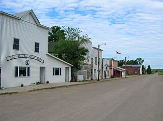
Plaza is a city in Mountrail County, North Dakota, United States. The population was 211 at the 2020 census. Plaza was founded in 1906. The business district is built around a central town square, city park or "plaza". A key feature of the plaza is a recently completed large covered gazebo.

<span class="mw-page-title-main">Ross, North Dakota</span> City in North Dakota, United States

Ross is a city in Mountrail County, North Dakota, United States. The population was 95 at the 2020 census.

<span class="mw-page-title-main">White Earth, North Dakota</span> City in North Dakota, United States

White Earth is a small City in Montrail County, North Dakota, United States. It is one of the oldest communities in Mountrail County, having been founded in 1887. The population was 100 at the 2020 census. There is a City Hall at White Earth, community center, two churches and a granary; and no other businesses or services.

<span class="mw-page-title-main">Hankinson, North Dakota</span> City in North Dakota, United States

Hankinson is a city in Richland County, North Dakota, United States. The population was 921 at the 2020 census. Hankinson was founded in 1886. It is part of the Wahpeton, ND–MN Micropolitan Statistical Area.

<span class="mw-page-title-main">Belfield, North Dakota</span> City in North Dakota, United States

Belfield is a city in Stark County, North Dakota, United States and only 15 minutes from Theodore Roosevelt National Park. The population was 996 at the 2020 census. Belfield was founded in 1883, and has seen many boom and busts in this oil-rich part of North Dakota. It is part of the Dickinson Micropolitan Statistical Area.

<span class="mw-page-title-main">Ryder, North Dakota</span> City in North Dakota, United States

Ryder is a city in Ward County, North Dakota, United States. The population was 108 at the 2020 census. It is part of the Minot Micropolitan Statistical Area. Ryder was founded in 1906.

<span class="mw-page-title-main">Ray, North Dakota</span> City in North Dakota, United States

Ray is a city in Williams County, North Dakota, United States. The population was 740 at the 2020 census.

<span class="mw-page-title-main">Tioga, North Dakota</span> City in North Dakota, United States

Tioga is a city in Williams County, North Dakota, United States. The population was 2,202 at the 2020 census.

References

  1. "ArcGIS REST Services Directory". United States Census Bureau. Retrieved September 20, 2022.
  2. 1 2 U.S. Geological Survey Geographic Names Information System: Stanley, North Dakota
  3. 1 2 3 "Explore Census Data". United States Census Bureau . Retrieved October 19, 2023.
  4. 1 2 "City and Town Population Totals: 2020-2022". United States Census Bureau. October 19, 2023. Retrieved October 19, 2023.
  5. "Find a County". National Association of Counties. Retrieved June 7, 2011.
  6. History of North Dakota, Embracing a Relation of the History of the State from the Earliest Times Down to the Present Day. Bismarck Tribune Company. 1910. p. 631.
  7. "US Gazetteer files 2010". United States Census Bureau. Archived from the original on January 12, 2012. Retrieved June 14, 2012.
  8. Davey, Monica. - "Oil in North Dakota Brings Job Boom and Burdens". - New York Times . - January 1, 2008. - | - "Tiny North Dakota Town Sitting on Oil Jackpot". - Nightline. - ABC News. - | - Gutierrez, Thelma, and Wayne Drash. - "North Dakota's real-life Jed Clampett". - CNN. - August 6, 2008. - | - Retrieved: August 7, 2008
  9. United States Census Bureau. "Census of Population and Housing" . Retrieved July 29, 2013.
  10. "CNN.com". CNN.
  11. "Remembering September 11, 2001: Ann Nicole Nelson Obituary". Legacy.com . December 2, 2001. Retrieved September 26, 2016.
  12. Jackson, William (2021). Dakota Mysteries & Oddities, 2022 Edition. Dickinson, ND: Valley Star Publications. pp. 27–28. ISBN   978-0-9677349-9-6.
  13. Bugliosi, Vincent (2007). Reclaiming History: The Assassination of President John F. Kennedy. W.W. Norton & Company. p. 1022. ISBN   978-0393045253.
  14. "Stanley, North Dakota Köppen Climate Classification (Weatherbase)" . Retrieved September 26, 2016.
  15. "Stanley 3 NNW, North Dakota 1991-2020 Monthly Normals" . Retrieved December 26, 2023.
  16. "xmACIS". National Oceanic and Atmospheric Administration. Retrieved December 26, 2023.