Plaza, North Dakota

Last updated

Plaza, North Dakota
Plaza, North Dakota 10-09-2008.jpg
Street in Plaza
ND Mountrail County Plaz.svg
Location of Plaza, North Dakota
Coordinates: 48°01′34″N101°57′34″W / 48.02611°N 101.95944°W / 48.02611; -101.95944
CountryUnited States
State North Dakota
County Mountrail
Founded1906
Area
[1]
  Total1.09 sq mi (2.84 km2)
  Land1.08 sq mi (2.80 km2)
  Water0.01 sq mi (0.03 km2)
Elevation
[2]
2,097 ft (639 m)
Population
 (2020)
  Total211
  Density195.01/sq mi (75.28/km2)
Time zone UTC-6 (CST)
  Summer (DST) UTC-5 (CDT)
ZIP code
58771
Area code 701
FIPS code 38-62980
GNIS feature ID1036224 [2]
Website plazand.com

Plaza is a city in Mountrail County, North Dakota, United States. The population was 211 at the 2020 census. [3] Plaza was founded in 1906. The business district is built around a central town square, city park or "plaza". A key feature of the plaza is a recently completed large covered gazebo.

Contents

Geography

According to the United States Census Bureau, the city has a total area of 1.13 square miles (2.93 km2), of which 1.12 square miles (2.90 km2) is land and 0.01 square miles (0.03 km2) is water. [4]

Demographics

Historical population
CensusPop.Note
1910 224
1920 34554.0%
1930 40818.3%
1940 360−11.8%
1950 3898.1%
1960 385−1.0%
1970 291−24.4%
1980 222−23.7%
1990 193−13.1%
2000 167−13.5%
2010 1712.4%
2020 21123.4%
2021 (est.)199 [5] −5.7%
U.S. Decennial Census [6]
2020 Census [3]

2010 census

As of the census of 2010, there were 171 people, 84 households, and 41 families residing in the city. The population density was 152.7 inhabitants per square mile (59.0/km2). There were 114 housing units at an average density of 101.8 per square mile (39.3/km2). The racial makeup of the city was 93.0% White, 1.8% Native American, 2.9% from other races, and 2.3% from two or more races. Hispanic or Latino of any race were 6.4% of the population.

There were 84 households, of which 17.9% had children under the age of 18 living with them, 42.9% were married couples living together, 4.8% had a female householder with no husband present, 1.2% had a male householder with no wife present, and 51.2% were non-families. 46.4% of all households were made up of individuals, and 10.7% had someone living alone who was 65 years of age or older. The average household size was 2.04 and the average family size was 2.93.

The median age in the city was 47.5 years. 18.1% of residents were under the age of 18; 7.7% were between the ages of 18 and 24; 20.5% were from 25 to 44; 36.9% were from 45 to 64; and 17% were 65 years of age or older. The gender makeup of the city was 56.1% male and 43.9% female.

2000 census

As of the census of 2000, there were 167 people, 80 households, and 47 families residing in the city. The population density was 148.7 inhabitants per square mile (57.4/km2). There were 115 housing units at an average density of 102.4 per square mile (39.5/km2). The racial makeup of the city was 91.02% White, 8.38% Native American and 0.60% Asian.

There were 80 households, out of which 25.0% had children under the age of 18 living with them, 50.0% were married couples living together, 6.3% had a female householder with no husband present, and 41.3% were non-families. 38.8% of all households were made up of individuals, and 25.0% had someone living alone who was 65 years of age or older. The average household size was 2.09 and the average family size was 2.77.

In the city, the population was spread out, with 23.4% under the age of 18, 3.0% from 18 to 24, 27.5% from 25 to 44, 19.2% from 45 to 64, and 26.9% who were 65 years of age or older. The median age was 43 years. For every 100 females, there were 116.9 males. For every 100 females age 18 and over, there were 109.8 males.

The median income for a household in the city was $22,143, and the median income for a family was $29,063. Males had a median income of $24,107 versus $14,375 for females. The per capita income for the city was $14,356. About 4.1% of families and 7.3% of the population were below the poverty line, including none of those under the age of eighteen and 26.7% of those 65 or over.

Education

It is within the Lewis and Clark School District, [7] which formed in 2003 when the Plaza School District merged with two other districts. [8] There is a school in Plaza, NSP Public School. [9]

Related Research Articles

<span class="mw-page-title-main">Warwick, North Dakota</span> City in North Dakota, United States

Warwick is a city in Benson County, North Dakota, United States. The population was 55 at the 2020 census. Warwick was founded in 1907.

<span class="mw-page-title-main">Lincoln, North Dakota</span> City in North Dakota, United States

Lincoln is a city in Burleigh County, North Dakota, United States. It is a suburb of adjacent Bismarck, and also a core city of the Bismarck-Mandan Metropolitan Statistical Area. The population was 4,257 at the 2020 census, making it the fourteenth largest city in North Dakota. Lincoln was founded in 1977.

<span class="mw-page-title-main">Wishek, North Dakota</span> City in North Dakota, United States

Wishek is a city in McIntosh County, North Dakota, United States. The population was 864 at the 2020 census.

<span class="mw-page-title-main">New Town, North Dakota</span> City in North Dakota, United States

New Town is a city in Mountrail County, North Dakota. The population was 2,764 at the time of the 2020 census, making it the 18th largest city in North Dakota. New Town was platted in 1950 as a replacement site for the residents of Sanish and Van Hook, as these towns were scheduled to be flooded by the creation of Lake Sakakawea, a reservoir to provide water for irrigation.

<span class="mw-page-title-main">Palermo, North Dakota</span> City in Mountrail County, North Dakota, United States

Palermo is a city in Mountrail County, North Dakota, United States. The population was 125 at the 2020 census.

<span class="mw-page-title-main">Parshall, North Dakota</span> City in North Dakota, United States

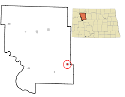
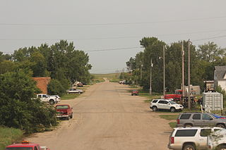
Parshall is a city lying within the jurisdictional boundaries of the Mandan, Hidatsa, and Arikara Nation. It is located on the Fort Berthold Indian Reservation in Mountrail County, North Dakota, United States. The population was 949 at the 2020 census. Parshall was founded in 1914 by George Parshall, and is the home of the Paul Broste Rock Museum.

<span class="mw-page-title-main">Ross, North Dakota</span> City in North Dakota, United States

Ross is a city in Mountrail County, North Dakota, United States. The population was 95 at the 2020 census.

<span class="mw-page-title-main">Stanley, North Dakota</span> City in North Dakota, United States

Stanley is a city in Mountrail County, North Dakota, United States. It is the county seat of Mountrail County. The population was 2,579 at the 2020 census, making it the 20th largest city in North Dakota. Stanley was founded in 1902. The town's economy is heavily connected to the nearby oil-rich Bakken Formation.

<span class="mw-page-title-main">White Earth, North Dakota</span> City in North Dakota, United States

White Earth is one of the oldest cities in Mountrail County, North Dakota, United States. The population was 100 at the 2020 census. White Earth township was founded in 1887.

<span class="mw-page-title-main">Hoople, North Dakota</span> City in North Dakota, United States

Hoople is a city in Walsh County, North Dakota, United States. The population was 247 at the 2020 census. Hoople, named for early settler Alan Hoople, was founded in 1889. Hoople's nickname is "Tatertown."

<span class="mw-page-title-main">Park River, North Dakota</span> City in North Dakota, United States

Park River is a city in Walsh County, North Dakota, United States. The population was 1,424 at the 2020 census. Park River was founded in 1884.

<span class="mw-page-title-main">Kenmare, North Dakota</span> City in North Dakota, United States

Kenmare is a city in Ward County, North Dakota, United States. The population was 961 at the 2020 census. Kenmare is part of the Minot Micropolitan Statistical Area.

<span class="mw-page-title-main">White, South Dakota</span> City in South Dakota, United States

White is a city in Brookings County, South Dakota, United States. The population was 537 at the 2020 census.

<span class="mw-page-title-main">Clear Lake, South Dakota</span> City in South Dakota, United States

Clear Lake is a city in and the county seat of Deuel County, South Dakota, United States. The population was 1,218 at the 2020 census.

<span class="mw-page-title-main">Corsica, South Dakota</span> City in South Dakota, United States

Corsica is a city in Douglas County, South Dakota, United States. The population was 561 at the 2020 census.

<span class="mw-page-title-main">Milbank, South Dakota</span> City in South Dakota, United States

Milbank is a city in Grant County, South Dakota, United States, located along the South Fork of the Whetstone River. The population was 3,544 at the 2020 census. It is the county seat of Grant County. Milbank is the birthplace of American Legion Baseball. The program was created in Milbank in 1925 and is now enjoyed by high school aged youth on more than five thousand teams in all fifty states.

<span class="mw-page-title-main">Parkston, South Dakota</span> City in South Dakota, United States

Parkston is a city in Hutchinson County, South Dakota, United States. The population was 1,567 at the 2020 census.

<span class="mw-page-title-main">Kadoka, South Dakota</span> City in South Dakota, United States

Kadoka is a city in, and the county seat of, Jackson County, South Dakota, United States. The population was 543 at the 2020 census. The town occupies about 2.3 square miles.

<span class="mw-page-title-main">Leola, South Dakota</span> City in South Dakota, United States

Leola is a small city in, and the county seat of, McPherson County, South Dakota, United States. It was founded on May 1, 1884, and named for Leola Haynes, daughter of one of the town's founders. The population was 434 as of the 2020 census.

<span class="mw-page-title-main">Crooks, South Dakota</span> City in South Dakota, United States

Crooks is a city in Minnehaha County, South Dakota, United States and is a suburb of Sioux Falls. The population was 1,362 at the 2020 census. Crooks was named New Hope until 1904. The town's present name honors W. A. Crooks, a local politician.

References

  1. "ArcGIS REST Services Directory". United States Census Bureau. Retrieved September 20, 2022.
  2. 1 2 U.S. Geological Survey Geographic Names Information System: Plaza, North Dakota
  3. 1 2 "Explore Census Data". United States Census Bureau . Retrieved July 19, 2022.
  4. "US Gazetteer files 2010". United States Census Bureau. Archived from the original on January 25, 2012. Retrieved June 14, 2012.
  5. "City and Town Population Totals: 2020-2021". United States Census Bureau. July 19, 2022. Retrieved July 19, 2022.
  6. United States Census Bureau. "Census of Population and Housing" . Retrieved July 29, 2013.
  7. "2020 CENSUS - SCHOOL DISTRICT REFERENCE MAP: Mountrail County, ND" (PDF). United States Census Bureau . Retrieved August 15, 2021.
  8. "More school districts merging". Bismarck Tribune . Bismarck, North Dakota. November 21, 2002. p. 2B. - Clipping from Newspapers.com.
  9. "NSP Public School / Homepage".