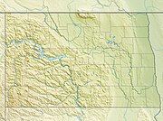
North Dakota is a state in the upper Midwestern United States. It is named after the Lakota and Dakota Sioux Native American tribes, who comprise a large portion of the population and historically dominated the territory. It is the nineteenth largest in area, the fourth least populous, and the fourth most sparsely populated of the 50 states with a population of 779,702 according to the 2020 census. Its capital is Bismarck, and its largest city is Fargo.

Mountrail County is a county in the northwestern part of North Dakota, United States. As of the 2010 census, the population was 7,673. Its county seat is Stanley. The county was originally created in 1873, then removed in 1892, annexed by Ward County. It was re-created and organized in 1909.
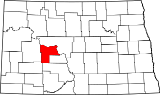
Mercer County is a county in the U.S. state of North Dakota. As of the 2010 United States Census, the population was 8,424. Its county seat is Stanton.

McLean County is a county in the U.S. state of North Dakota. As of the 2010 United States Census, the population was 8,962. Its county seat is Washburn.

New Town is a city in Mountrail County, North Dakota, United States. The population was 1,925 at the 2010 census. New Town was platted in 1950 as a replacement site for the residents of Sanish and Van Hook Township, as these towns were scheduled to be flooded by the creation of Lake Sakakawea, a reservoir to provide water for irrigation.
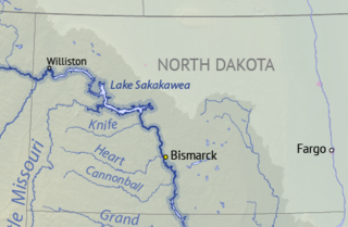
Lake Sakakawea is a large reservoir in the north central United States, impounded in 1953 by Garrison Dam, a U.S. Army Corps of Engineers dam located in the Missouri River basin in central North Dakota. Named for the Shoshone-Hidatsa woman Sakakawea, it is the largest man-made lake located entirely within the State of North Dakota, the second largest in the United States by area after Lake Oahe, and the third largest in the United States by volume, after Lake Mead and Lake Powell.

Garrison Dam is an earth-fill embankment dam on the Missouri River in central North Dakota, U.S.. Constructed by the U.S. Army Corps of Engineers from 1947 to 1953, at over 2 miles (3.2 km) in length, the dam is the fifth-largest earthen dam in the world. The reservoir impounded by the dam is Lake Sakakawea, which extends to Williston and the confluence with the Yellowstone River, near the Montana border.

The Fort Berthold Indian Reservation is a U.S. Indian reservation in western North Dakota that is home for the federally recognized Mandan, Hidatsa, and Arikara Nation, also known as the Three Affiliated Tribes. The reservation includes lands on both sides of the Missouri River.
Bismarck is the capital of the state of North Dakota, the county seat of Burleigh County, and the second most populous city in North Dakota after Fargo. The city was formed in 1872 as "Edwinton" after Edwin Ferry Johnson, a chief engineer for the Northern Pacific Railway company, when the railroad reached the eastern banks of the Missouri River. The name was changed less than one year later, honoring German chancellor Otto von Bismarck, in an effort to attract German immigrants. The discovery of gold in the nearby Black Hills in 1874 was the first real impetus for growth. In 1883, Bismarck became the capital of the Dakota Territory and, in 1889, of the state of North Dakota.

Huff is an unincorporated community in Morton County, North Dakota, United States. Huff is located about 20 miles south of Bismarck, North Dakota on the Missouri River at the top of Lake Oahe, a reservoir created by a dam. It is located on North Dakota Highway 1806. Huff is the nearest town to Huff Archeological Site, a U.S. National Historic Landmark. As of 2018, the population is estimated to be less than 15, no businesses are currently in operation. Present at the townsite are the remains of a one-room school, an abandoned repair shop/gas station, a few occupied homes, and a restored stone church.

Shields is an unincorporated community in Grant County, North Dakota, United States. Founded by Nathaniel J. Shields and his wife Mary and their four children in 1896. Shields' population peaked in 1920 with 250 people. Its elevation is 1,808 feet (551 m) above sea level. Although it is unincorporated, it has a post office, with the ZIP code of 58569.

Verendrye is an unincorporated community in McHenry County, North Dakota, United States, located approximately eight miles northwest of Karlsruhe and 13 miles northeast of Velva within Falsen Township. Although classified by the USGS as a populated place, it is considered a ghost town.
Fort Berthold was two sequential forts on the Missouri River in North Dakota, both of which began as fur trading posts. The second became a post for the U.S. Army and later became the Indian Agency for the Arikara, Hidatsa, and Mandan tribes. The sites are both now under Lake Sakakawea.

Carbury is an unincorporated community in Bottineau County in the U.S. state of North Dakota. It is located along North Dakota Highway 14 in the eastern part of the county, east of Souris. The town is virtually abandoned, and the 2000 Census did not record a population. The post office closed in 1984, and it is now part of zip code 58783 covered by the post office in Souris.
Van Hook Township is a township in Mountrail County in the U.S. state of North Dakota. At the time of the 2000 Census, its population was 42, and estimated to be 41 as of 2009.
Gottlieb Charles Wachter (1865–1928), commonly known by his middle name, was a German-born businessman and city commissioner in Bismarck, North Dakota, USA. Wachter is best remembered as the patriarch of one of the earliest and most prominent families of North Dakota's capital city.

Crow Flies High State Recreation Area is a scenic overlook located two miles west of New Town in Mountrail County, North Dakota. The site provides scenic views of Lake Sakakawea. Signs describe the location's role in local history, including its significance in the explorations of Lewis and Clark. The footprint of the drowned town of Sanish, now lost below the reservoir's waves, can be seen at times of low water.

Sanish is an unincorporated community in Mountrail County, North Dakota, United States. Sanish is located along North Dakota Highway 23 and Lake Sakakawea, 2.6 miles (4.2 km) west of New Town.

Van Hook State Wildlife Management Area is a Wildlife Management Area on the Van Hook Arm of Lake Sakakawea in Mountrail County, North Dakota. The Van Hook Arm of Lake Sakakawea is managed by a different county than the Garrison Dam which formed it. The closest town to the WMA is New Town, North Dakota and the Soo Line Railroad runs through it on its way to Parshall, North Dakota.