Van Hook Township, Mountrail County, North Dakota

Last updated

Van Hook Township, North Dakota
USA North Dakota location map.svg
Red pog.svg
Van Hook Township, North Dakota
Location within the state of North Dakota
Coordinates: 47°58′14″N102°19′58″W / 47.97056°N 102.33278°W / 47.97056; -102.33278
Country United States
State North Dakota
County Mountrail
Area
[1]
  Total36.5 sq mi (95 km2)
  Land32.9 sq mi (85 km2)
  Water3.6 sq mi (9 km2)
Elevation
1,903 ft (580 m)
Population
 (2000) [2]
  Total42
  Density1.3/sq mi (0.5/km2)
Time zone UTC-6 (Central (CST))
  Summer (DST) UTC-5 (CDT)
Area code 701
FIPS code 38-81420 [3]
GNIS feature ID1037116 [4]

Van Hook Township is a township in Mountrail County in the U.S. state of North Dakota. At the time of the 2000 Census, its population was 42, [2] and estimated to be 41 as of 2009. [5]

Contents

History

The township is named for Fred Van Hook who helped survey the area in the early 1910s. A Soo Line Railroad station was established at Van Hook in 1914, resulting in rapid population growth. Van Hook Township's population grew from 65 in 1910 to 278 in 1920, at which time it was counted as an organized civil township. [6] The population peaked 1930. [7]

The village of Van Hook continued to grow, reaching a population of 380 in 1950. However, the town soon declined after it was flooded by Lake Sakakawea. [7] Most of the residents were relocated to the nearby city of New Town after the city disincorporated in 1953. [8]

The resort community of Van Hook in Van Hook township has since been rebuilt on the old town site most of which was never flooded. It is currently a thriving community on the north shore of Lake Sakakawea with both permanent and summer residents. The community is unincorporated, and many of the homes are second homes for residents. US Census population is untabulated. The 2018 population of Van Hook township far exceeds 42, especially if summer residents are counted.

Geography

Much of the township is part of the Fort Berthold Indian Reservation. [4] The township covers 36.5 square miles (95 km2), 10 percent (2.6 sq mi (6.7 km2)) of which is underwater. The southern portion of the township was flooded when Lake Sakakawea was created due to construction of Garrison Dam in the early 1950s. Lake Sakakawea's Van Hook Arm is named for the township. [4]

Demographics

As of the 2000 Census, [2] there were 42 individuals, 23 households, and 13 families living in the township but this number seriously underestimates the number of people who have homes in the township. On average, the population density was 1.3 inhabitants per square mile (0.50/km2). [1] Racially, based on those who identified having only one race in their responses to the Census, the township was 31% White and 12% were American Indians. 57.1% of the township identified themselves as being from two or more races. The 2000 Census also allowed respondents to select more than one race. [9] When that is taken into account, 88.1% of the residents identified themselves as White and 14.3% identified themselves as American Indian. [2]

Related Research Articles

<span class="mw-page-title-main">Bennett County, South Dakota</span> County in South Dakota, United States

Bennett County is a county in the U.S. state of South Dakota. As of the 2020 census, the population was 3,381. Its county seat is Martin. The county lies completely within the exterior boundary of the Pine Ridge Indian Reservation. To the east is the Rosebud Indian Reservation, occupied by Sicangu Oyate, also known the Upper Brulé Sioux Nation and the Rosebud Sioux Tribe (RST), a branch of the Lakota people.

<span class="mw-page-title-main">Mountrail County, North Dakota</span> County in North Dakota, United States

Mountrail County is a county in the northwestern part of North Dakota, United States. As of the 2020 census, the population was 9,809. Its county seat is Stanley. The county was originally created in 1873, then removed in 1892, annexed by Ward County. It was re-created and organized in 1909.

<span class="mw-page-title-main">Mercer County, North Dakota</span> County in North Dakota, United States

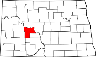
Mercer County is a county in the U.S. state of North Dakota. As of the 2020 census, the population was 8,350. Its county seat is Stanton.

<span class="mw-page-title-main">McKenzie County, North Dakota</span> County in North Dakota, United States

McKenzie County is a county in the U.S. state of North Dakota. As of the 2020 census, the population was 14,704. Its county seat is Watford City.

<span class="mw-page-title-main">Benson County, North Dakota</span> County in North Dakota, United States

Benson County is a county in the U.S. state of North Dakota. As of the 2020 census, the population was 5,964. Its county seat is Minnewaukan. The county was created on March 9, 1883 by the Dakota Territory legislature, and was named for Bertil W. Benson, a Dakota Territory legislator at the time. The county government was organized on June 4, 1884, and its boundary lines were altered by two legislative actions in 1885.

<span class="mw-page-title-main">Silver Creek Township, Michigan</span> Civil township in Michigan, United States

Silver Creek Township is a civil township of Cass County in the U.S. state of Michigan. The population was 3,218 at the 2010 census.

<span class="mw-page-title-main">Antler, North Dakota</span> City in North Dakota, United States

Antler is a city in Bottineau County in the U.S. state of North Dakota. The population was 22 at the 2020 census. Antler was founded in 1905.

<span class="mw-page-title-main">Hazen, North Dakota</span> City in North Dakota, United States

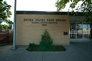
Hazen is a city in Mercer County, North Dakota, United States. The population was 2,281 at the 2020 census. Hazen was founded in 1913. Hazen has a K–12 school system.

<span class="mw-page-title-main">New Town, North Dakota</span> City in North Dakota, United States

New Town is a city in Mountrail County, North Dakota. The population was 2,764 at the time of the 2020 census, making it the 18th largest city in North Dakota. New Town was platted in 1950 as a replacement site for the residents of Sanish and Van Hook, as these towns were scheduled to be flooded by the creation of Lake Sakakawea, a reservoir to provide water for irrigation.

<span class="mw-page-title-main">Lake Sakakawea</span> Man-made reservoir in North Dakota, United States

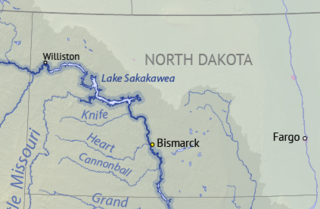
Lake Sakakawea is a large reservoir in the north central United States, impounded in 1953 by Garrison Dam, a U.S. Army Corps of Engineers dam located in the Missouri River basin in central North Dakota. Named for the Shoshone-Hidatsa woman Sakakawea, it is the largest man-made lake located entirely within North Dakota, the second largest in the United States by area after Lake Oahe, and the third largest in the United States by volume, after Lake Mead and Lake Powell.

Adler Township is one of the twenty-seven townships of Nelson County, North Dakota, United States. Its population during the 2000 Census was 47, and an estimated 38 as of 2009.

<span class="mw-page-title-main">Fort Berthold Indian Reservation</span> Indian reservation in the United States

The Fort Berthold Indian Reservation is a U.S. Indian reservation in western North Dakota that is home for the federally recognized Mandan, Hidatsa, and Arikara Nation, also known as the Three Affiliated Tribes. The reservation includes lands on both sides of the Missouri River. The tribal headquarters is in New Town, the 18th largest city in North Dakota.

<span class="mw-page-title-main">Van Hook, North Dakota</span> Former Ghost town currently a thriving resort town in North Dakota, United States

Van Hook is a thriving resort community built on the shores of Lake Sakakawea. The town was disbanded in the 1950s with the flooding of Lake Sakakawea and for a very short period of time was classified as a ghost town in the north central United States, located in Van Hook Township in Mountrail County, North Dakota. The original town site was mostly left not flooded when Lake Sakakawea was formed in the 1950s behind Garrison Dam.

<span class="mw-page-title-main">Omemee, North Dakota</span> Place in North Dakota, United States

Omemee is a ghost town in Bottineau County in the U.S. state of North Dakota. It was a railroad hub in the early 1910s, located at the junction of two major railroads, the Soo Line Railroad and the Great Northern Railway. Incorporated as a city in 1902, Omemee has been abandoned since 2003.

Rock Township is a civil township in Benson County, North Dakota, United States. As of the 2000 census, its population was 39.

Mission Township is a civil township in Benson County, North Dakota, United States. As of the 2000 census, its population was 1,077. It is the most populous township in the county.

<span class="mw-page-title-main">Pickering Township, Bottineau County, North Dakota</span> Township in North Dakota, United States

Pickering Township is a civil township in Bottineau County in the U.S. state of North Dakota. Its population was 193 as of the 2010 census, down from 213 at the 2000 census.

Schrunk Township is a civil township in Burleigh County in the U.S. state of North Dakota. As of the 2000 census, its population was 26, but had increased to an estimated 71 by 2009.

Land Township is a civil township in McHenry County in the U.S. state of North Dakota. As of the 2000 census, its population was 48. The population in 2009 was estimated at 42. The township was organized in 1907.

References

  1. 1 2 U.S. Census Bureau. Census 2000, Summary File 1. "GCT-PH1. Population, Housing Units, Area, and Density: 2000 - County -- Subdivision and Place". American FactFinder. <http://factfinder2.census.gov>. Retrieved January 31, 2008.
  2. 1 2 3 4 U.S. Census Bureau. Census 2000. "Census Demographic Profiles, Van Hook Township" (PDF). CenStats Databases. Retrieved January 31, 2009.[ dead link ]
  3. "U.S. Census website". United States Census Bureau . Retrieved January 31, 2008.
  4. 1 2 3 "US Board on Geographic Names". United States Geological Survey. October 25, 2007. Retrieved January 31, 2008.
  5. U.S. Census Bureau (2010). "Incorporated Places and Minor Civil Divisions: North Dakota". 2009 Population Estimates. Archived from the original (CSV) on June 27, 2010. Retrieved June 22, 2010.
  6. U.S. Census Bureau (1921). "Number and Distribution of Inhabitants, North Dakota" (PDF). Fourteenth Census of the United States: 1920. Government Printing Office . Retrieved July 20, 2008.
  7. 1 2 U.S. Census Bureau (1952). "Number of Inhabitants, North Dakota" (PDF). Census of Population: 1950. Government Printing Office . Retrieved July 20, 2008.
  8. Wick, Douglas A. (1988). North Dakota Place Names. Bismarck, North Dakota: Hedemarken Collectibles. p. 10. ISBN   0-9620968-0-6. OCLC   191277027.
  9. U.S. Census Bureau. "Racial and Ethnic Classifications Used in Census 2000 and Beyond". Archived from the original on November 27, 2001. Retrieved July 6, 2010.