Bowbells, North Dakota

Last updated

Bowbells, North Dakota
Bowbells, North Dakota 5-21-2008.jpg
Business district of Bowbells
ND Burke County Bowbells.svg
Location of Bowbells, North Dakota
Usa edcp location map.svg
Red pog.svg
Bowbells, North Dakota
Location in the United States
Coordinates: 48°48′10″N102°14′44″W / 48.80278°N 102.24556°W / 48.80278; -102.24556
CountryUnited States
State North Dakota
County Burke
Founded1898
Incorporated1906
Area
[1]
  Total0.97 sq mi (2.52 km2)
  Land0.95 sq mi (2.46 km2)
  Water0.02 sq mi (0.05 km2)
Elevation
[2]
1,962 ft (598 m)
Population
 (2020)
  Total301
  Density316.51/sq mi (122.24/km2)
Time zone UTC-6 (CST)
  Summer (DST) UTC-5 (CDT)
ZIP code
58721
Area code 701
FIPS code 38-08500
GNIS feature ID1035937 [2]
Website bowbellsnd.com

Bowbells is a city in and the county seat of Burke County, North Dakota, United States. The population was 301 at the 2020 census. [3]

Contents

History

The city of Bowbells was founded in 1898 along the main line of the Soo Line Railroad and incorporated in 1906. The city was named by railroad officials after the famed Bow bells at St Mary-le-Bow in London, England. [4]

The city's centennial celebration was held in the third week in July, 2006. Several hundred people from all over the country registered and attended. Burke County celebrated its centennial in the summer of 2010.

Culture

The town is home to a Lutheran, a Methodist, and a Roman Catholic church.

A municipal golf course is located four miles east of the city, and a community swimming pool, park and campground are available as well for visitors and residents.

Bowbells' schoolhouse, built in 1909 at a cost of $15,000, is still in use. Due to attentive management over the years, the brick building is still in good condition and currently houses kindergarten through sixth grade students. The building has a jerkinhead roof, combining gable and hipped roof types. [5]

Economy

Farmers in the area produce crops such as barley, canola, flax, oats, peas, sunflowers, durum and Hard Red Spring Wheat. There have been substantial oil wells in the area and thus oil-related businesses, including drilling, service and distribution businesses.

Some of the businesses in the town include an implement dealership, SunPrairie Grain (a division of CHS Incorporated), Savage Industries, and government-related buildings and businesses. The town's main street includes a gas station, a service station, a handful of crop and property insurance agencies, Dacotah Bank, The Newly Remodeled Historic Bowbells Hotel and North Dakota Wine Kitchen. Since Bowbells is the county seat of Burke County, the county courthouse is located here. It's on the southwest side of town. The official county newspaper, The Burke County Tribune newspaper, is located in the city as well. [6]

Montana-Dakota Utilities provides electrical service to the town. [7] There is no municipal natural gas service.

Geography

Bowbells is located a few miles west of Upper Des Lacs Lake and the Des Lacs National Wildlife Refuge. The Des Lacs valley was formed as meltwater flowed out of Glacial Lake Regina thousands of years ago.

Bowbells is about 20 km (12 mi) south of the Canada–US border, just off a 90-degree bend in U.S. Highway 52 and along the Canadian Pacific Railway, a railway serving the SunPrairie Grain grain terminal there. It is located approximately 52 miles northwest of Minot, the nearest city with an international airport (MOT) and 30 miles north of Stanley, the nearest passenger train station.

According to the United States Census Bureau, the city has a total area of 0.81 square miles (2.10 km2), of which 0.80 square miles (2.07 km2) is land and 0.01 square miles (0.03 km2) is water. [8]

Demographics

Historical population
CensusPop.Note
1910 651
1920 643−1.2%
1930 6958.1%
1940 78713.2%
1950 8062.4%
1960 687−14.8%
1970 584−15.0%
1980 5870.5%
1990 498−15.2%
2000 406−18.5%
2010 336−17.2%
2020 301−10.4%
2021 (est.)286 [9] −5.0%
U.S. Decennial Census [10]
2020 Census [3]

2010 census

As of the census of 2010, there were 336 people, 161 households, and 93 families residing in the city. The population density was 420.0 inhabitants per square mile (162.2/km2). There were 223 housing units at an average density of 278.8 per square mile (107.6/km2). The racial makeup of the city was 96.4% White, 0.6% Native American, 2.7% Asian, and 0.3% from two or more races. Hispanic or Latino of any race were 0.6% of the population.

There were 161 households, of which 24.2% had children under the age of 18 living with them, 46.6% were married couples living together, 7.5% had a female householder with no husband present, 3.7% had a male householder with no wife present, and 42.2% were non-families. 36.0% of all households were made up of individuals, and 16.2% had someone living alone who was 65 years of age or older. The average household size was 2.09 and the average family size was 2.70.

The median age in the city was 47.7 years. 21.4% of residents were under the age of 18; 6.7% were between the ages of 18 and 24; 18.3% were from 25 to 44; 34.7% were from 45 to 64; and 19% were 65 years of age or older. The gender makeup of the city was 52.4% male and 47.6% female.

2000 census

As of the census of 2000, there were 406 people, 174 households, and 116 families residing in the town. The population density was 511.2 inhabitants per square mile (197.4/km2). There were 214 housing units at an average density of 269.5 per square mile (104.1/km2). The racial makeup of the town was 98.77% White, 0.74% Native American, 0.25% Asian, and 0.25% from two or more races. Hispanic or Latino of any race were 0.25% of the population.

There were 174 households, out of which 31.6% had children under the age of 18 living with them, 55.7% were married couples living together, 7.5% had a female householder with no husband present, and 33.3% were non-families. 32.2% of all households were made up of individuals, and 19.5% had someone living alone who was 65 years of age or older. The average household size was 2.33 and the average family size was 2.97.

In the town the population was spread out, with 27.3% under the age of 18, 3.7% from 18 to 24, 24.9% from 25 to 44, 23.2% from 45 to 64, and 20.9% who were 65 years of age or older. About 100 K-12 students attend the town's local public school. The median age was 42 years. For every 100 females, there were 91.5 males. For every 100 females age 18 and over, there were 90.3 males.

The median income for a household in the town was $30,455, and the median income for a family was $35,625. Males had a median income of $30,833 versus $12,212 for females. The per capita income for the town was $15,491. About 9.2% of families and 8.6% of the population were below the poverty line, including 8.1% of those under age 18 and 5.9% of those age 65 or over.

Notable people

Climate

This climatic region is typified by large seasonal temperature differences, with warm to hot (and often humid) summers and cold (sometimes severely cold) winters. According to the Köppen Climate Classification system, Bowbells has a humid continental climate, abbreviated "Dfb" on climate maps. [11]

See also

Related Research Articles

<span class="mw-page-title-main">Sigourney, Iowa</span> City in Iowa, United States

Sigourney is a city in Keokuk County, Iowa, United States. The population was 2,004 at the time of the 2020 census. It is the county seat of Keokuk County. Keokuk County Courthouse is located in the Public Square Historic District. Both are on the National Register of Historic Places.

<span class="mw-page-title-main">Hettinger, North Dakota</span> City in North Dakota, United States

Hettinger is a city in, and the county seat of, Adams County, North Dakota, United States. The population was 1,074 at the 2020 census.

<span class="mw-page-title-main">Warwick, North Dakota</span> City in North Dakota, United States

Warwick is a city in Benson County, North Dakota, United States. The population was 55 at the 2020 census. Warwick was founded in 1907.

<span class="mw-page-title-main">Columbus, North Dakota</span> City in North Dakota, United States

Columbus is a city in Burke County, North Dakota, United States. The population was 139 at the 2020 census. Columbus was founded in 1906. Both this town and nearby Larson were named for an early postmaster who served the area, making it possibly the only town so named that was not named for Christopher Columbus.

<span class="mw-page-title-main">Flaxton, North Dakota</span> City in North Dakota, United States

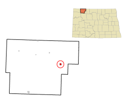
Flaxton is a city in Burke County, North Dakota, United States. The population was 60 at the 2020 census. Flaxton was founded in 1900 and was named because the predominant crop in the area is flax.

<span class="mw-page-title-main">Lignite, North Dakota</span> City in North Dakota, United States

Lignite is a city in Burke County, North Dakota, United States. The population was 141 at the 2020 census. Lignite was founded in 1907 and was named for the quantities of lignite, a low-grade coal, present in the area.

<span class="mw-page-title-main">Alice, North Dakota</span> City in North Dakota, United States

Alice is a city in Cass County, North Dakota, United States. The population was 41 at the 2020 census.

<span class="mw-page-title-main">Gardner, North Dakota</span> City in North Dakota, United States

Gardner is a city in Cass County, North Dakota, United States. The population was 129 at the 2020 census.

<span class="mw-page-title-main">New Rockford, North Dakota</span> City in North Dakota, United States

New Rockford is a city in Eddy County, North Dakota, United States. It is the county seat of Eddy County. The population was 1,361 at the 2020 census. New Rockford was founded in 1883.

<span class="mw-page-title-main">Cooperstown, North Dakota</span> City in North Dakota, United States

Cooperstown is a city in Griggs County, North Dakota, United States. It is the county seat of Griggs County. The population was 983 at the 2020 census. Cooperstown was founded in 1882.

<span class="mw-page-title-main">Flasher, North Dakota</span> City in North Dakota, United States

Flasher is a city in Morton County, North Dakota, United States. It is part of the "Bismarck, ND Metropolitan Statistical Area" or "Bismarck-Mandan". The population was 217 at the 2020 census. Flasher was founded in 1902.

<span class="mw-page-title-main">Des Lacs, North Dakota</span> City in North Dakota, United States

Des Lacs is a city in Ward County, North Dakota, United States. The population was 185 at the 2020 census. It is part of the Minot Micropolitan Statistical Area. Des Lacs was founded in 1888, named after the Riviere de Lacs, from the French for "River [of] The Lakes."

<span class="mw-page-title-main">Chamberlain, South Dakota</span> City in South Dakota, United States

Chamberlain is a city in Brule County, South Dakota, United States. It is located on the east bank of the Missouri River, at the dammed section of the Lake Francis Case, close to where it is crossed by Interstate 90.

<span class="mw-page-title-main">Florence, South Dakota</span> Town in South Dakota, United States

Florence is a town in northwestern Codington County, South Dakota, United States. It is part of the Watertown, South Dakota Micropolitan Statistical Area. The population was 337 at the 2020 census.

<span class="mw-page-title-main">Gary, South Dakota</span> City in South Dakota, United States

Gary is a city in Deuel County, South Dakota, United States. The population was 240 at the 2020 census. South Dakota Highway 101 serves as the main route of the community. In 2022, the town celebrated its 150th anniversary.

<span class="mw-page-title-main">Burke, South Dakota</span> City in South Dakota, United States

Burke is a city in and county seat of Gregory County, South Dakota, United States. The population was 575 at the 2020 census.

<span class="mw-page-title-main">Gregory, South Dakota</span> City in South Dakota, United States

Gregory is a city in western Gregory County, South Dakota, United States. The population was 1,221 at the 2020 census.

<span class="mw-page-title-main">Parkston, South Dakota</span> City in South Dakota, United States

Parkston is a city in Hutchinson County, South Dakota, United States. The population was 1,567 at the 2020 census.

<span class="mw-page-title-main">Murdo, South Dakota</span> City in South Dakota, United States

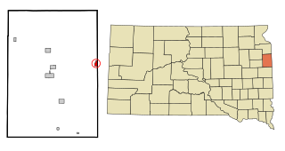
Murdo is a city in and county seat of Jones County, South Dakota, United States. The population was 475 at the 2020 census.

<span class="mw-page-title-main">Redfield, South Dakota</span> City in South Dakota, United States

Redfield is a city in and the county seat of Spink County, South Dakota, United States. The population was 2,214 at the 2020 census. The city was named for J. B. Redfield, a railroad official.

References

  1. "ArcGIS REST Services Directory". United States Census Bureau. Retrieved September 20, 2022.
  2. 1 2 U.S. Geological Survey Geographic Names Information System: Bowbells, North Dakota
  3. 1 2 "Explore Census Data". United States Census Bureau . Retrieved July 18, 2022.
  4. Wick, Douglas A. "Bowbells (Burke County)". North Dakota Place Names. Retrieved May 9, 2011.
  5. Jackson, William (2021). Dakota Mysteries & Oddities, 2022 Edition. Dickinson, ND: Valley Star Publishing. p. 67. ISBN   978-0-9677349-9-6.
  6. NEWSPAPER: Website [ permanent dead link ]
  7. UTILITY: Website Archived February 8, 2013, at the Wayback Machine
  8. "US Gazetteer files 2010". United States Census Bureau. Archived from the original on January 12, 2012. Retrieved June 14, 2012.
  9. "City and Town Population Totals: 2020-2021". United States Census Bureau. July 18, 2022. Retrieved July 18, 2022.
  10. United States Census Bureau. "Census of Population and Housing" . Retrieved September 7, 2013.
  11. Climate Summary for Bowbells, North Dakota

48°48′14″N102°14′46″W / 48.8038°N 102.2462°W / 48.8038; -102.2462