Steele, North Dakota

Last updated

Steele, North Dakota
Steele Community Center - Steele, North Dakota 6-10-2008.jpg
Steele Community Center in Steele
ND Kidder County Steele.svg
Location of Steele, North Dakota
Coordinates: 46°51′24″N99°55′05″W / 46.85667°N 99.91806°W / 46.85667; -99.91806
CountryUnited States
State North Dakota
County Kidder
Platted1878
Founded1880
Government
   Mayor Jonathan Harter
Area
[1]
  Total0.56 sq mi (1.44 km2)
  Land0.56 sq mi (1.44 km2)
  Water0.00 sq mi (0.00 km2)
Elevation
[2]
1,864 ft (568 m)
Population
 (2020) [3]
  Total665
  Estimate 
(2022) [4]
666
  Density1,198.20/sq mi (462.36/km2)
Time zone UTC-6 (Central (CST))
  Summer (DST) UTC-5 (CDT)
ZIP code
58482
Area code 701
FIPS code 38-75780
GNIS feature ID1036287 [2]
Website steelend.com

Steele is a city in Kidder County, North Dakota, United States. It is the county seat of Kidder County. [5] The population was 665 at the 2020 census. [3]

Contents

History

Steele was platted in 1878 by Wilbur F. Steele, and named for him. [6] The community got its start soon after the railroad was extended to that point. [7] A post office has been in operation at Steele since 1880. [8] The Kidder County Courthouse was built in 1883.

The high temperature was 121 degrees Fahrenheit in Steele, N.D. on July 6, 1936. [9]

Geography

According to the United States Census Bureau, the city has a total area of 0.57 square miles (1.48 km2), all land. [10]

Climate

On July 6, 1936, the temperature in Steele soared to 121 °F (49.4 °C), the highest temperature ever recorded in the state of North Dakota. This event, during the 1936 North American heat wave, is even more remarkable because since 1948, the temperature has not exceeded 109 °F (42.8 °C). It was the highest temperature recorded so far north on the North American continent until June 29, 2021, when it was exceeded in Lytton, British Columbia by 0.3 °F (0.2 °C). A prolonged period of extreme drought across the entire Great Plains contributed to the extreme heat. Record high temperatures for 15 states fell that summer. In the United States, higher temperatures have been recorded in only four states: California, Arizona, Nevada, and New Mexico. (Kansas set its own 121 °F record on July 24.)

According to the averages, Steele has a humid continental climate (Dfb) with warm to hot summers and very cold winters, typical of the Great Plains. Though summer's highs average 83 °F (28.3 °C) there are still 17–18 days on average of above 90 °F (32.2 °C). [11] January nights average 2 °F (−16.7 °C), and subzero temperatures happen on multiple occasions every winter.

Climate data for Steele, North Dakota (1991–2020 normals, extremes 1894–present)
MonthJanFebMarAprMayJunJulAugSepOctNovDecYear
Record high °F (°C)55
(13)
64
(18)
80
(27)
95
(35)
110
(43)
109
(43)
121
(49)
106
(41)
105
(41)
95
(35)
76
(24)
67
(19)
121
(49)
Mean daily maximum °F (°C)20.5
(−6.4)
24.9
(−3.9)
38.0
(3.3)
54.5
(12.5)
67.3
(19.6)
75.8
(24.3)
81.8
(27.7)
81.2
(27.3)
72.0
(22.2)
56.1
(13.4)
38.8
(3.8)
25.0
(−3.9)
53.0
(11.7)
Daily mean °F (°C)10.9
(−11.7)
15.2
(−9.3)
27.7
(−2.4)
41.9
(5.5)
54.3
(12.4)
63.9
(17.7)
69.4
(20.8)
67.8
(19.9)
58.8
(14.9)
44.3
(6.8)
28.8
(−1.8)
16.3
(−8.7)
41.6
(5.3)
Mean daily minimum °F (°C)1.4
(−17.0)
5.5
(−14.7)
17.5
(−8.1)
29.4
(−1.4)
41.4
(5.2)
52.0
(11.1)
56.9
(13.8)
54.5
(12.5)
45.6
(7.6)
32.4
(0.2)
18.9
(−7.3)
7.5
(−13.6)
30.2
(−1.0)
Record low °F (°C)−44
(−42)
−50
(−46)
−35
(−37)
−7
(−22)
11
(−12)
26
(−3)
32
(0)
26
(−3)
10
(−12)
−12
(−24)
−25
(−32)
−42
(−41)
−50
(−46)
Average precipitation inches (mm)0.63
(16)
0.61
(15)
0.95
(24)
1.41
(36)
2.81
(71)
3.43
(87)
3.36
(85)
2.57
(65)
2.12
(54)
1.81
(46)
0.86
(22)
0.80
(20)
21.36
(543)
Average snowfall inches (cm)8.5
(22)
5.6
(14)
7.9
(20)
2.0
(5.1)
0.1
(0.25)
0.0
(0.0)
0.0
(0.0)
0.0
(0.0)
0.0
(0.0)
0.8
(2.0)
6.2
(16)
9.0
(23)
40.1
(102)
Average precipitation days (≥ 0.01 in)5.54.65.17.110.411.19.97.57.36.95.45.786.5
Average snowy days (≥ 0.1 in)4.93.32.91.00.10.00.00.00.00.82.34.419.7
Source: NOAA (snow 1981–2010) [12] [13] [14]

Demographics

Historical population
CensusPop.Note
1890 133
1900 18539.1%
1910 500170.3%
1920 55010.0%
1930 519−5.6%
1940 72138.9%
1950 7625.7%
1960 84711.2%
1970 696−17.8%
1980 79614.4%
1990 762−4.3%
2000 761−0.1%
2010 715−6.0%
2020 665−7.0%
2022 (est.)666 [4] 0.2%
U.S. Decennial Census [15]
2020 Census [3]

2010 census

As of the census of 2010, there were 715 people, 316 households, and 194 families residing in the city. The population density was 1,254.4 inhabitants per square mile (484.3/km2). There were 362 housing units at an average density of 635.1 per square mile (245.2/km2). The racial makeup of the city was 95.9% White, 0.7% African American, 0.3% Native American, 2.1% Asian, 0.7% from other races, and 0.3% from two or more races. Hispanic or Latino of any race were 1.5% of the population.

There were 316 households, of which 27.5% had children under the age of 18 living with them, 47.8% were married couples living together, 7.9% had a female householder with no husband present, 5.7% had a male householder with no wife present, and 38.6% were non-families. 35.4% of all households were made up of individuals, and 19.3% had someone living alone who was 65 years of age or older. The average household size was 2.26 and the average family size was 2.89.

The median age in the city was 41.9 years. 25.5% of residents were under the age of 18; 6.2% were between the ages of 18 and 24; 21.6% were from 25 to 44; 25.5% were from 45 to 64; and 21.4% were 65 years of age or older. The gender makeup of the city was 47.8% male and 52.2% female.

2000 census

As of the census of 2000, there were 761 people, 336 households, and 191 families residing in the city. The population density was 1,338.5 inhabitants per square mile (516.8/km2). There were 367 housing units at an average density of 645.5 per square mile (249.2/km2). The racial makeup of the city was 99.61% White, 0.13% African American and 0.26% Native American.

There were 336 households, out of which 23.8% had children under the age of 18 living with them, 47.6% were married couples living together, 6.8% had a female householder with no husband present, and 42.9% were non-families. 40.5% of all households were made up of individuals, and 28.0% had someone living alone who was 65 years of age or older. The average household size was 2.13 and the average family size was 2.88.

In the city, the population was spread out, with 22.6% under the age of 18, 4.9% from 18 to 24, 22.9% from 25 to 44, 17.9% from 45 to 64, and 31.8% who were 65 years of age or older. The median age was 45 years. For every 100 females, there were 87.0 males. For every 100 females age 18 and over, there were 75.8 males.

The median income for a household in the city was $27,841, and the median income for a family was $37,778. Males had a median income of $35,250 versus $20,673 for females. The per capita income for the city was $16,767. About 8.7% of families and 14.1% of the population were below the poverty line, including 14.1% of those under age 18 and 20.0% of those age 65 or over.

See also

Related Research Articles

<span class="mw-page-title-main">Leal, North Dakota</span> City in North Dakota, United States

Leal is a city in Barnes County in the state of North Dakota. The population was 27 at the 2020 census. Leal was founded in 1892. The name comes from the Scots word for "faithful," which in the phrase laund o the leal means Heaven.

<span class="mw-page-title-main">Warwick, North Dakota</span> City in North Dakota, United States

Warwick is a city in Benson County, North Dakota, United States. The population was 55 at the 2020 census. Warwick was founded in 1907.

<span class="mw-page-title-main">New Rockford, North Dakota</span> City in North Dakota, United States

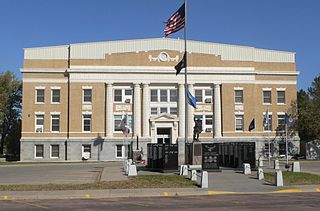
New Rockford is a city in Eddy County, North Dakota, United States. It is the county seat of Eddy County. The population was 1,361 at the 2020 census. New Rockford was founded in 1883.

<span class="mw-page-title-main">Cooperstown, North Dakota</span> City in North Dakota, United States

Cooperstown is a city in Griggs County, North Dakota, United States. It is the county seat of Griggs County. The population was 983 at the 2020 census. Cooperstown was founded in 1882.

<span class="mw-page-title-main">New England, North Dakota</span> City in North Dakota, United States

New England is a city in Hettinger County, North Dakota, United States. The population was 683 at the 2020 census.

<span class="mw-page-title-main">Napoleon, North Dakota</span> City in North Dakota, United States

Napoleon is a city in Logan County, North Dakota, United States. It is the county seat of Logan County. The population was 749 at the 2020 census.

<span class="mw-page-title-main">Granville, North Dakota</span> City in North Dakota, United States

Granville is a city in McHenry County, North Dakota, United States. The population was 240 at the 2020 census. It is part of the Minot Micropolitan Statistical Area. Granville was founded in 1900.

<span class="mw-page-title-main">Parshall, North Dakota</span> City in North Dakota, United States

Parshall is a city lying within the jurisdictional boundaries of the Mandan, Hidatsa, and Arikara Nation. It is located on the Fort Berthold Indian Reservation in Mountrail County, North Dakota, United States. The population was 949 at the 2020 census. Parshall was founded in 1914 by George Parshall, and is the home of the Paul Broste Rock Museum.

<span class="mw-page-title-main">Stanley, North Dakota</span> City in North Dakota, United States

Stanley is a city in Mountrail County, North Dakota, United States. It is the county seat of Mountrail County. The population was 2,321 at the 2020 census, making it the 22nd largest city in North Dakota. Stanley was founded in 1902. The town's economy is heavily connected to the nearby oil-rich Bakken Formation.

<span class="mw-page-title-main">Lakota, North Dakota</span> City in North Dakota, United States

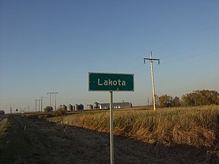
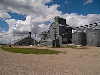
Lakota is a city in Nelson County, North Dakota, United States. It is the county seat of Nelson County Lakota is located 63 miles west of Grand Forks and 27 miles east of Devils Lake. The population was 683 at the 2020 census, making Lakota the 75th-largest city in North Dakota.

<span class="mw-page-title-main">Hankinson, North Dakota</span> City in North Dakota, United States

Hankinson is a city in Richland County, North Dakota, United States. The population was 921 at the 2020 census. Hankinson was founded in 1886. It is part of the Wahpeton, ND–MN Micropolitan Statistical Area.

<span class="mw-page-title-main">Rolla, North Dakota</span> City in North Dakota, United States

Rolla is a town in Rolette County, North Dakota, United States. It is the county seat of Rolette County. The population was 1,223 at the 2020 census. The town contains a small park and a small outdoor pool.

<span class="mw-page-title-main">Finley, North Dakota</span> City in North Dakota, United States

Finley is a city in Steele County, North Dakota. It is the county seat of Steele County. The population was 401 at the 2020 census. Finley was founded in 1897.

<span class="mw-page-title-main">Hope, North Dakota</span> City in North Dakota, United States

Hope is a city in Steele County, North Dakota, United States. The population was 272 at the 2020 census. Hope was founded in 1881.

<span class="mw-page-title-main">Sharon, North Dakota</span> City in North Dakota, United States

Sharon is a city in Steele County, North Dakota, United States. The population was 86 at the 2020 census. Sharon was founded in 1896.

<span class="mw-page-title-main">Park River, North Dakota</span> City in North Dakota, United States

Park River is a city in Walsh County, North Dakota, United States. The population was 1,424 at the 2020 census. Park River was founded in 1884.

<span class="mw-page-title-main">Kenmare, North Dakota</span> City in North Dakota, United States

Kenmare is a city in Ward County, North Dakota, United States. The population was 961 at the 2020 census. Kenmare is part of the Minot Micropolitan Statistical Area.

<span class="mw-page-title-main">Philip, South Dakota</span> City in South Dakota, United States

Philip is a city in and the county seat of rural Haakon County, South Dakota, United States. The population was 759 at the 2020 census.

<span class="mw-page-title-main">Castlewood, South Dakota</span> Town in South Dakota, United States

Castlewood is a city in Hamlin County, South Dakota, United States. It is part of the Watertown, South Dakota Micropolitan Statistical Area. The population was 698 at the 2020 census. and was estimated to be 707 in 2022.

<span class="mw-page-title-main">Winner, South Dakota</span> City in South Dakota, United States

Winner is a city in central Tripp County, South Dakota, United States. The population was 2,921 at the 2020 census. It is the county seat of Tripp County. Winner also serves as the administrative center of neighboring Todd County, which does not have its own county seat. The nearest airport is Winner Regional Airport.

References

  1. "ArcGIS REST Services Directory". United States Census Bureau. Retrieved September 20, 2022.
  2. 1 2 U.S. Geological Survey Geographic Names Information System: Steele, North Dakota
  3. 1 2 3 "Explore Census Data". United States Census Bureau . Retrieved October 7, 2023.
  4. 1 2 "City and Town Population Totals: 2020-2022". United States Census Bureau. October 7, 2023. Retrieved October 7, 2023.
  5. "Find a County". National Association of Counties. Retrieved June 7, 2011.
  6. North Dakota: Counties, Towns & People. Watchmaker Publishing, Ltd. 2008. p. 111. ISBN   978-1-60386-191-5.
  7. Hellmann, Paul T. (February 14, 2006). Historical Gazetteer of the United States. Routledge. p. 841. ISBN   1-135-94859-3.
  8. "Kidder County". Jim Forte Postal History. Retrieved October 23, 2015.
  9. "The U.S. is sweltering. The heat wave of 1936 was far deadlier". Washington Post. ISSN   0190-8286 . Retrieved April 27, 2023.
  10. "US Gazetteer files 2010". United States Census Bureau. Archived from the original on July 2, 2012. Retrieved June 14, 2012.
  11. "Steele, North Dakota Travel Weather Averages (Weatherbase)".
  12. "NowData - NOAA Online Weather Data". National Oceanic and Atmospheric Administration. Retrieved September 24, 2021.
  13. "Station: Steele 4N, ND". U.S. Climate Normals 2020: U.S. Monthly Climate Normals (1991-2020). National Oceanic and Atmospheric Administration. Retrieved September 24, 2021.
  14. "Station: Steele, ND". U.S. Monthly Climate Normals (1981-2010). National Oceanic and Atmospheric Administration. Retrieved September 24, 2021.
  15. United States Census Bureau. "Census of Population and Housing" . Retrieved October 30, 2013.