New Rockford, North Dakota

Last updated

New Rockford, North Dakota
Eddy County Courthouse 2008.jpg
Eddy County Courthouse in New Rockford
ND Eddy County New Rockford.svg
Location of New Rockford, North Dakota
Coordinates: 47°40′47″N99°08′15″W / 47.67972°N 99.13750°W / 47.67972; -99.13750
CountryUnited States
State North Dakota
County Eddy
Founded1883
Government
  City AuditorAndrew Presnell
Area
[1]
  Total1.75 sq mi (4.53 km2)
  Land1.72 sq mi (4.45 km2)
  Water0.03 sq mi (0.08 km2)
Elevation
[2]
1,532 ft (467 m)
Population
 (2020) [3]
  Total1,361
  Estimate 
(2022) [4]
1,339
  Density792.20/sq mi (305.82/km2)
Time zone UTC-6 (Central (CST))
  Summer (DST) UTC-5 (CDT)
ZIP code
58356
Area code 701
FIPS code 38-56620
GNIS feature ID1036182 [2]
Highways US 281, ND 15
Website cityofnewrockford.com

New Rockford is a city in Eddy County, North Dakota, United States. It is the county seat of Eddy County. [5] The population was 1,361 at the 2020 census. [3] New Rockford was founded in 1883.

Contents

History

New Rockford was founded in 1883, when the Great Northern Railway arrived in the area. [6]

In 1915, residents mounted a challenge to have the state capital relocated from Bismarck to New Rockford. This did not succeed, leaving Bismarck the capital.

Geography

According to the United States Census Bureau, the city has an area of 1.54 square miles (3.99 km2), of which 1.51 square miles (3.91 km2) is land and 0.03 square miles (0.08 km2) is water. [7] New Rockford's zip code is 58356.

Demographics

Historical population
CensusPop.Note
1920 2,111
1930 2,1954.0%
1940 2,017−8.1%
1950 2,1858.3%
1960 2,177−0.4%
1970 1,969−9.6%
1980 1,791−9.0%
1990 1,604−10.4%
2000 1,463−8.8%
2010 1,391−4.9%
2020 1,361−2.2%
2023 (est.)1,339 [4] −1.6%
U.S. Decennial Census [8]
2020 Census [3]

2010 census

As of the census of 2010, there were 1,391 people, 628 households, and 363 families living in the city. The population density was 921.2 inhabitants per square mile (355.7/km2). There were 750 housing units at an average density of 496.7 per square mile (191.8/km2). The racial makeup of the city was 95.7% White, 0.1% African American, 1.7% Native American, 0.4% Asian, 0.1% Pacific Islander, 0.9% from other races, and 1.2% from two or more races. Hispanic or Latino people of any race were 2.9%.

Of the 628 households 24.7% had children under the age of 18 living with them, 44.9% were married couples living together, 9.4% had a female householder with no husband present, 3.5% had a male householder with no wife present, and 42.2% were non-families. 38.4% of households were one person and 22% were one person aged 65 or older. The average household size was 2.08 and the average family size was 2.74.

The median age was 50.2 years. 20.8% of residents were under the age of 18; 4.8% were between the ages of 18 and 24; 18.3% were from 25 to 44; 28.8% were from 45 to 64; and 27.2% were 65 or older. The gender makeup of the city was 46.2% male and 53.8% female.

2000 census

As of the census of 2000, there were 1,463 people, 651 households, and 378 families living in the city. The population density was 970.7 inhabitants per square mile (374.8/km2). There were 778 housing units at an average density of 516.2 per square mile (199.3/km2). The racial makeup of the city was 98.02% White, 0.14% African American, 1.50% Native American, 0.14% from other races, and 0.21% from two or more races. Hispanic or Latino people of any race were 0.55% of the population.

Of the 651 households 24.7% had children under the age of 18 living with them, 49.8% were married couples living together, 6.1% had a female householder with no husband present, and 41.8% were non-families. 39.3% of households were one person and 24.7% were one person aged 65 or older. The average household size was 2.13 and the average family size was 2.84.

The age distribution was 20.8% under the age of 18, 6.4% from 18 to 24, 21.3% from 25 to 44, 21.9% from 45 to 64, and 29.7% 65 or older. The median age was 46 years. For every 100 females, there were 84.5 males. For every 100 females age 18 and over, there were 80.0 males.

The median household income was $28,042 and the median family income was $43,438. Males had a median income of $26,080 versus $19,219 for females. The per capita income for the city was $16,444. About 6.2% of families and 9.0% of the population were below the poverty line, including 8.3% of those under age 18 and 15.3% of those age 65 or over.

Events

Notable people

Education

New Rockford is served by New Rockford-Sheyenne Public School.

Climate

This climatic region is typified by large seasonal temperature differences, with warm to hot (and often humid) summers and cold (sometimes severely cold) winters. According to the Köppen Climate Classification system, New Rockford has a humid continental climate, abbreviated "Dfb" on climate maps. [9]

Related Research Articles

<span class="mw-page-title-main">Rockford, Iowa</span> City in Iowa, United States

Rockford is a city in Floyd County, Iowa, United States, at the confluence of the Shell Rock and Winnebago rivers. The population was 758 at the time of the 2020 census.

<span class="mw-page-title-main">Rockford, Michigan</span> City in Michigan, United States

Rockford is a city in Kent County in the U.S. state of Michigan. The population was 5,719 at the 2010 census.

<span class="mw-page-title-main">Hettinger, North Dakota</span> City in North Dakota, United States

Hettinger is a city in, and the county seat of, Adams County, North Dakota, United States. The population was 1,074 at the 2020 census.

<span class="mw-page-title-main">Dazey, North Dakota</span> City in North Dakota, United States

Dazey is a city in Barnes County, North Dakota, United States. The population was 78 at the 2020 census. Dazey was founded in 1883 after a local farmer, Charles Dazey, donated land to start a townsite.

<span class="mw-page-title-main">Brinsmade, North Dakota</span> City in North Dakota, United States

For people with the surname, see Brinsmade (surname).

<span class="mw-page-title-main">Esmond, North Dakota</span> City in North Dakota, United States

Esmond is a city in Benson County, North Dakota, United States. The population was 91 at the 2020 census. Esmond was founded in 1901.

<span class="mw-page-title-main">Kramer, North Dakota</span> City in North Dakota, United States

Kramer is a city in Bottineau County, North Dakota, United States. The population was 24 at the 2020 census. Kramer was founded in 1905.

<span class="mw-page-title-main">Bowman, North Dakota</span> City in North Dakota, United States

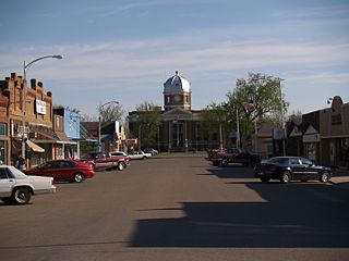
Bowman is a city and county seat of Bowman County, North Dakota, United States. The population was 1,470 at the 2020 census.

<span class="mw-page-title-main">Crosby, North Dakota</span> City in North Dakota

Crosby is a city and the county seat of Divide County, North Dakota, United States. The population was 1,065 at the 2020 census.

<span class="mw-page-title-main">Thompson, North Dakota</span> City in North Dakota, United States

Thompson is a city in Grand Forks County, North Dakota, United States. It is part of the "Grand Forks, ND-MN Metropolitan Statistical Area" or "Greater Grand Forks". It is located on the border of Allendale and Walle townships, with Walle on the east and Allendale on the west. The population was 1,101 at the 2020 census. Thompson was founded in 1881.

<span class="mw-page-title-main">Watford City, North Dakota</span> City in North Dakota, United States

Watford City, founded in 1914, is a city in and the county seat of McKenzie County, North Dakota, United States. The population was 6,207 at the 2020 census, making it the 13th most populous city in North Dakota. Because Watford City is part of the Bakken field, the North Dakota oil boom has significantly increased population and construction since the 2010 census.

<span class="mw-page-title-main">Wagner, South Dakota</span> City in South Dakota, United States

Wagner is a city in Charles Mix County, South Dakota, United States. The population was 1,490 at the 2020 census. The city is served by Wagner Municipal Airport as well as YST Transit buses.

<span class="mw-page-title-main">Parkston, South Dakota</span> City in South Dakota, United States

Parkston is a city in Hutchinson County, South Dakota, United States. The population was 1,567 at the 2020 census.

<span class="mw-page-title-main">Tripp, South Dakota</span> City in South Dakota, United States

Tripp is a city in Hutchinson County, South Dakota, United States. The population was 575 in the 2020 census.

<span class="mw-page-title-main">Central City, South Dakota</span> City in South Dakota, United States

Central City is a city in Lawrence County, South Dakota, United States. The population was 93 at the 2020 census.

<span class="mw-page-title-main">Lennox, South Dakota</span> City in South Dakota, United States

Lennox is a city in Lincoln County, South Dakota, United States, located 20 miles (32 km) southwest of Sioux Falls. The population was 2,423 at the 2020 census.

<span class="mw-page-title-main">Veblen, South Dakota</span> City in South Dakota, United States

Veblen is a city in Marshall County, South Dakota, United States. The population was 317 at the 2020 census.

<span class="mw-page-title-main">White River, South Dakota</span> City in South Dakota, United States

White River is a city in and the county seat of Mellette County. South Dakota, United States. The population was 533 at the 2020 census.

<span class="mw-page-title-main">Crooks, South Dakota</span> City in South Dakota, United States

Crooks is a city in Minnehaha County, South Dakota, United States and is a suburb of Sioux Falls. The population was 1,362 at the 2020 census. Crooks was named New Hope until 1904. The town's present name honors W. A. Crooks, a local politician.

<span class="mw-page-title-main">Rockford, Minnesota</span> City in Minnesota, United States

Rockford is a city in Wright and Hennepin counties in the U.S. state of Minnesota. The population was 4,316 at the 2010 census. While Rockford is mainly located within Wright County, a small part of the city extends into Hennepin County. It is part of the Minneapolis–Saint Paul metropolitan statistical area. Minnesota State Highway 55 serves as a main route in the city.

References

  1. "ArcGIS REST Services Directory". United States Census Bureau. Retrieved September 20, 2022.
  2. 1 2 U.S. Geological Survey Geographic Names Information System: New Rockford, North Dakota
  3. 1 2 3 "Explore Census Data". United States Census Bureau . Retrieved October 23, 2023.
  4. 1 2 "City and Town Population Totals: 2020-2022". United States Census Bureau. October 23, 2023. Retrieved October 23, 2023.
  5. "Find a County". National Association of Counties. Retrieved June 7, 2011.
  6. Hellmann, Paul T. (May 13, 2013). Historical Gazetteer of the United States. Routledge. p. 840. ISBN   978-1135948597 . Retrieved November 30, 2013.
  7. "US Gazetteer files 2010". United States Census Bureau. Archived from the original on January 25, 2012. Retrieved June 14, 2012.
  8. United States Census Bureau. "Census of Population and Housing" . Retrieved February 12, 2014.
  9. Climate Summary for New Rockford, North Dakota