Bowman County, North Dakota

Last updated

Bowman County
Bank in Bowman.jpg
Dakota Western Bank in Bowman, North Dakota
Map of North Dakota highlighting Bowman County.svg
Location within the U.S. state of North Dakota
North Dakota in United States.svg
North Dakota's location within the U.S.
Coordinates: 46°07′N103°31′W / 46.11°N 103.52°W / 46.11; -103.52
CountryFlag of the United States.svg United States
StateFlag of North Dakota.svg  North Dakota
Founded1883 (created)
1907 (organized)
Named for Edward M. Bowman
Seat Bowman
Largest cityBowman
Area
  Total1,167 sq mi (3,020 km2)
  Land1,162 sq mi (3,010 km2)
  Water5.2 sq mi (13 km2)  0.4%
Population
 (2020)
  Total2,993
  Estimate 
(2022)
2,894 Decrease2.svg
  Density2.6/sq mi (0.99/km2)
Time zone UTC−7 (Mountain)
  Summer (DST) UTC−6 (MDT)
Congressional district At-large
Website bowmannd.com

Bowman County is a county in the U.S. state of North Dakota. As of the 2020 census, the population was 2,993. [1] Its county seat is Bowman. [2]

Contents

History

The legislature of the Dakota Territory designated Bowman (named for Edward M. Bowman, a member of the territorial House of Representatives during the 1883 session) as a separate county on March 8, 1883, although it was not organized at that time. In 1885, its boundaries were altered to cede territory to Billings and Villard Counties (Villard itself was eliminated in 1887). In 1891, and again in 1896, the South Dakota legislature eliminated the not-yet-organized Bowman County, due to scant settlement in the area, but these actions either were not put into effect (the 1891 vote) or were overturned in judicial appeal (the 1896 vote).

A decision by the North Dakota supreme court on May 24, 1901, resurrected Bowman County. That decision also caused the county's area to slightly increase; its former boundary descriptions were replaced by descriptions based on the boundary lines of adjacent jurisdictions, which added a strip along its south border and another strip along its east border.

Since the scantily-populated county was still unorganized, in March 1903 the legislature attached the area to Stark County for judicial purposes. This state of affairs continued until November 1904, when the legislature again dissolved the county and assigned its territory to Billings County. However, on June 10, 1907, ND Governor John Burke issued a proclamation which re-created Bowman County. This proclamation did not attach the area to any other area for judicial purposes, so on July 5, 1907, the new county's organization was set up, and Bowman was confirmed as the county seat. [3] [4]

The US Navy ship USS Bowman County (LST-391), a tank landing ship in World War II, was named for this county.

Geography

Bowman County lies at the southwestern corner of North Dakota; its south boundary line abuts the north boundary line of the state of South Dakota, and its west boundary line abuts the east boundary line of the state of Montana. The Little Missouri River flows northward through the west part of the county; the North Fork of the Grand River flows easterly through the lower part of the county, filling Bowman-Haley Lake in the process. Spring Creek flows south-southeasterly through the central part of the county, discharging into Bowman-Haley Lake.

Bowman County's terrain consists of semi-arid high hills running north–south through the west-central part of the county, with lower hills in the remaining territory. The area is partially used for agriculture. [5] The western part slopes to the north and west; the eastern part slopes to the east and south. Its highest point is on the south boundary line, toward its southwestern corner, at 3,228 ft (984 m) ASL. [6] The county has a total area of 1,167 square miles (3,020 km2), of which 1,162 square miles (3,010 km2) is land and 5.2 square miles (13 km2) (0.4%) is water. [7]

Major highways

Adjacent counties

Lakes

[5]

Demographics

Historical population
CensusPop.Note
1910 4,668
1920 4,7682.1%
1930 5,1197.4%
1940 3,860−24.6%
1950 4,0013.7%
1960 4,1543.8%
1970 3,901−6.1%
1980 4,2298.4%
1990 3,596−15.0%
2000 3,242−9.8%
2010 3,151−2.8%
2020 2,993−5.0%
2022 (est.)2,894 [8] −3.3%
U.S. Decennial Census [9]
1790-1960 [10] 1900-1990 [11]
1990-2000 [12] 2010-2020 [1]

2020 census

As of the census of 2020, there were 2,993 people.

2010 census

As of the census of 2010, there were 3,151 people, 1,385 households, and 873 families in the county. The population density was 2.7 inhabitants per square mile (1.0/km2). There were 1,683 housing units at an average density of 1.4 per square mile (0.54/km2). The racial makeup of the county was 97.9% white, 0.6% American Indian, 0.1% black or African American, 0.1% Asian, 0.9% from other races, and 0.5% from two or more races. Those of Hispanic or Latino origin made up 2.5% of the population. In terms of ancestry, 47.4% were German, 28.1% were Norwegian, 9.9% were Irish, 6.4% were Swedish, 6.4% were English, 5.4% were American, and 5.2% were Polish.

Of the 1,385 households, 25.6% had children under the age of 18 living with them, 54.9% were married couples living together, 4.4% had a female householder with no husband present, 37.0% were non-families, and 32.9% of all households were made up of individuals. The average household size was 2.22 and the average family size was 2.82. The median age was 46.9 years.

The median income for a household in the county was $48,063 and the median income for a family was $63,897. Males had a median income of $41,542 versus $27,269 for females. The per capita income for the county was $27,354. About 3.9% of families and 6.7% of the population were below the poverty line, including 2.6% of those under age 18 and 14.8% of those age 65 or over.

Population by decade

Bowman County, North Dakota

Communities

Detailed map of Bowman County Map of Bowman County, North Dakota.svg
Detailed map of Bowman County

Cities

Unincorporated communities

[5]

Townships

Unorganized Territories

Politics

Bowman County voters have been reliably Republican for decades. In no national election since 1964 has the county selected the Democratic Party candidate (as of 2020).

United States presidential election results for Bowman County, North Dakota [13] [14]
Year Republican Democratic Third party
No.%No.%No.%
2020 1,39584.19%22813.76%342.05%
2016 1,44680.92%22712.70%1146.38%
2012 1,28073.69%41423.83%432.48%
2008 1,10767.50%47829.15%553.35%
2004 1,28074.59%39723.14%392.27%
2000 1,08073.42%33022.43%614.15%
1996 71048.20%48933.20%27418.60%
1992 71237.34%50626.53%68936.13%
1988 1,11159.51%73739.48%191.02%
1984 1,55972.55%56226.15%281.30%
1980 1,50770.49%45421.23%1778.28%
1976 1,03351.70%91145.60%542.70%
1972 1,11161.69%64335.70%472.61%
1968 92756.46%55934.04%1569.50%
1964 75641.38%1,07058.57%10.05%
1960 1,03854.98%84744.86%30.16%
1956 1,00758.34%71541.43%40.23%
1952 1,37571.21%54027.96%160.83%
1948 72349.83%59741.14%1319.03%
1944 78555.67%60943.19%161.13%
1940 92750.63%88248.17%221.20%
1936 53426.57%1,11855.62%35817.81%
1932 61628.31%1,29259.38%26812.32%
1928 1,03154.99%82143.79%231.23%
1924 77645.17%673.90%87550.93%
1920 1,19269.79%32118.79%19511.42%
1916 37432.49%68559.51%927.99%
1912 30229.18%36134.88%37235.94%
1908 45166.13%20930.65%223.23%

See also

Related Research Articles

<span class="mw-page-title-main">Adams County, North Dakota</span> County in North Dakota, United States

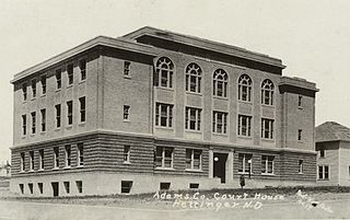
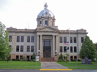
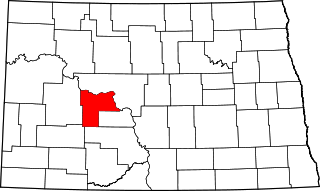
Adams County is a county in the U.S. state of North Dakota. As of the 2020 census, the population was 2,200. The county seat is Hettinger. The county was created on April 17, 1907, and organized one week later. It was named for John Quincy Adams (1848–1919), a railroad official for the Milwaukee Road Railroad and distant relative of sixth U.S. President John Quincy Adams (1767–1848).

<span class="mw-page-title-main">Hyde County, South Dakota</span> County in South Dakota, United States

Hyde County is a county in the U.S. state of South Dakota. As of the 2020 census, the population was 1,262, making it the second-least populous county in South Dakota. Its county seat is Highmore. The county was founded in 1873, as a county of the Dakota Territory, and organized in 1883. It was named for James Hyde, a member of legislature in the 1870s.

<span class="mw-page-title-main">Harding County, South Dakota</span> County in South Dakota, United States

Harding County is a county in the U.S. state of South Dakota. As of the 2020 census, the population was 1,311, making it the third-least populous county in South Dakota. Its county seat is Buffalo.

<span class="mw-page-title-main">Towner County, North Dakota</span> County in North Dakota, United States

Towner County is a county in the U.S. state of North Dakota. As of the 2020 census, the population is 2,162. Its county seat is Cando. It is south of the Canada–US border with Manitoba.

<span class="mw-page-title-main">Stark County, North Dakota</span> County in North Dakota, United States

Stark County is a county in the U.S. state of North Dakota. As of the 2020 census, the population was 33,646, making it the 7th most populous county in North Dakota. Its county seat is Dickinson.

<span class="mw-page-title-main">Slope County, North Dakota</span> County in North Dakota, United States

Slope County is a county in the U.S. state of North Dakota. As of the 2020 census, the population was 706, making it the least populous county in North Dakota and the 18th-least populous county in the United States. The county seat is Amidon.

<span class="mw-page-title-main">Sioux County, North Dakota</span> County in North Dakota, United States

Sioux County is a county located along the southern border of the U.S. state of North Dakota. As of the 2020 census, the population was 3,898. Its eastern border is the Missouri River and its county seat is Fort Yates.

<span class="mw-page-title-main">Richland County, North Dakota</span> County in North Dakota, United States

Richland County is a county in the far southeast corner of the U.S. state of North Dakota. As of the 2020 census, the population was 16,529. Its county seat is Wahpeton.

<span class="mw-page-title-main">Mountrail County, North Dakota</span> County in North Dakota, United States

Mountrail County is a county in the northwestern part of North Dakota, United States. As of the 2020 census, the population was 9,809. Its county seat is Stanley. The county was originally created in 1873, then removed in 1892, annexed by Ward County. It was re-created and organized in 1909.

<span class="mw-page-title-main">Mercer County, North Dakota</span> County in North Dakota, United States

Mercer County is a county in the U.S. state of North Dakota. As of the 2020 census, the population was 8,350. Its county seat is Stanton.

<span class="mw-page-title-main">McKenzie County, North Dakota</span> County in North Dakota, United States

McKenzie County is a county in the U.S. state of North Dakota. As of the 2020 census, the population was 14,704. Its county seat is Watford City.

<span class="mw-page-title-main">LaMoure County, North Dakota</span> County in North Dakota, United States

LaMoure County is a county in the U.S. state of North Dakota. As of the 2020 census, the population was 4,093. Its county seat is LaMoure.

<span class="mw-page-title-main">Hettinger County, North Dakota</span> County in North Dakota, United States

Hettinger County is a county in the U.S. state of North Dakota. As of the 2020 census, the population was 2,489. Its county seat is Mott.

<span class="mw-page-title-main">Grant County, North Dakota</span> County in North Dakota, United States

Grant County is a county in the U.S. state of North Dakota. As of the 2020 census, the population was 2,301. Its county seat is Carson.

<span class="mw-page-title-main">Grand Forks County, North Dakota</span> County in North Dakota, United States

Grand Forks County is a county in the U.S. state of North Dakota. As of the 2020 census, its population was 73,170, making it the third most populous county in North Dakota. Its county seat and largest community is Grand Forks.

<span class="mw-page-title-main">Foster County, North Dakota</span> County in North Dakota, United States

Foster County is a county in the U.S. state of North Dakota. As of the 2020 census, the population was 3,397. Its county seat is Carrington.

<span class="mw-page-title-main">Dunn County, North Dakota</span> County in North Dakota, United States

Dunn County is a county in the U.S. state of North Dakota. As of the 2020 census, the population was 4,095. Its county seat is Manning.

<span class="mw-page-title-main">Dickey County, North Dakota</span> County in North Dakota, United States

Dickey County is a county in the U.S. state of North Dakota. As of the 2020 census, the population was 4,999. Its county seat is Ellendale.

<span class="mw-page-title-main">Billings County, North Dakota</span> County in North Dakota, United States

Billings County is a county in the U.S. state of North Dakota. As of the 2020 census, the population was 945, making it the second-least populous county in North Dakota. Its county seat and only incorporated place is Medora.

<span class="mw-page-title-main">Rhame, North Dakota</span> City in North Dakota, United States

Rhame is a city in Bowman County, North Dakota, United States. The population was 158 at the 2020 census. Rhame was founded in 1908.

References

  1. 1 2 "State & County QuickFacts". United States Census Bureau. Retrieved April 4, 2023.
  2. "Find a County". National Association of Counties. Archived from the original on May 31, 2011. Retrieved June 7, 2011.
  3. "Dakota Territory, South Dakota, and North Dakota: Individual County Chronologies". Dakota Territory Atlas of Historical County Boundaries. The Newberry Library. 2006. Archived from the original on April 2, 2018. Retrieved February 2, 2015.
  4. "County History". Official Portal for North Dakota State Government. Archived from the original on February 2, 2015. Retrieved May 4, 2011.
  5. 1 2 3 Bowman County ND Google Maps (accessed February 15, 2019)
  6. ""Find an Altitude/Bowman County ND" Google Maps (accessed February 15, 2019)". Archived from the original on May 21, 2019. Retrieved February 15, 2019.
  7. "2010 Census Gazetteer Files". United States Census Bureau. August 22, 2012. Archived from the original on January 29, 2015. Retrieved January 27, 2015.
  8. "Annual Estimates of the Resident Population for Counties: April 1, 2020 to July 1, 2022". Census.gov . Retrieved April 4, 2023.
  9. "United States Decennial Census". United States Census Bureau. Retrieved January 27, 2015.
  10. "Historical Census Browser". University of Virginia Library. Retrieved January 27, 2015.
  11. Forstall, Richard L., ed. (March 27, 1995). "Population of Counties by Decennial Census: 1900 to 1990". United States Census Bureau. Retrieved January 27, 2015.
  12. "Census 2000 PHC-T-4. Ranking Tables for Counties: 1990 and 2000" (PDF). United States Census Bureau. April 2, 2001. Archived (PDF) from the original on March 27, 2010. Retrieved January 27, 2015.
  13. Leip, David. "Atlas of US Presidential Elections". uselectionatlas.org. Retrieved April 12, 2018.
  14. The leading "other" candidate, Progressive Theodore Roosevelt, received 258 votes, while Socialist candidate Eugene Debs received 99 votes, Prohibition candidate Eugene Chafin received 15 votes.

46°07′N103°31′W / 46.11°N 103.52°W / 46.11; -103.52