Renville County, North Dakota

Last updated

Renville County
Renville County Courthouse.jpg
Renville County Courthouse. Photographed in 1940.
Map of North Dakota highlighting Renville County.svg
Location within the U.S. state of North Dakota
North Dakota in United States.svg
North Dakota's location within the U.S.
Coordinates: 48°43′N101°40′W / 48.71°N 101.66°W / 48.71; -101.66
CountryFlag of the United States.svg United States
StateFlag of North Dakota.svg  North Dakota
FoundedJanuary 4, 1873 (created)
July 20, 1910 (organized)
Named for Joseph Renville
Seat Mohall
Largest cityMohall
Area
  Total893 sq mi (2,310 km2)
  Land877 sq mi (2,270 km2)
  Water16 sq mi (40 km2)  1.8%
Population
 (2020)
  Total2,282
  Estimate 
(2022)
2,220 Decrease2.svg
  Density2.6/sq mi (0.99/km2)
Time zone UTC−6 (Central)
  Summer (DST) UTC−5 (CDT)
Congressional district At-large
Website www.renvillecountynd.org

Renville County is a county in the U.S. state of North Dakota. As of the 2020 census, the population was 2,282. [1] Its county seat is Mohall. [2]

Contents

Renville County is part of the Minot, ND Micropolitan Statistical Area. It is located south of the Canada–United States border with Saskatchewan.

History

The Dakota Territory legislature created the county on January 4, 1873. It was named for Joseph Renville, an influential fur trader, interpreter, translator, and important figure in dealings between white men and the Sioux. The county was not organized at that time, nor was it attached to another county for administrative or judicial purposes. The proposed county boundaries were altered in 1883, in 1885, and 1887, and on November 8, 1892, the county was dissolved and absorbed into Bottineau and Ward counties due to a lack of settlement.

The general election held November 3, 1908 included a question asking whether a portion of Ward County should be partitioned off and named Renville County (covering a different area than the original county). This question reportedly failed to pass, but it was promptly contested in court, resulting in a ruling by the state Supreme Court ruled on June 3, 1910, that the split should be carried out. [3] The state governor proclaimed the result in a July 12 proclamation, and the county government was organized on July 20 of that year, [4] with Mohall as the county seat. [4] [5]

Outline map of Renville County, North Dakota, 1914 Map of Renville County, N.D., 1914.jpg
Outline map of Renville County, North Dakota, 1914

Geography

Renville County lies on the north line of North Dakota; its north boundary line abuts the south boundary line of Canada. The Souris River flows southeasterly through the county on its way to Hudson Bay. The county terrain consists of rolling hills, largely devoted to agriculture. [6] The terrain slopes to the south and east; its highest point is its SW corner, at 2,005 ft (611 m) ASL. [7] The county has a total area of 893 square miles (2,310 km2), of which 877 square miles (2,270 km2) is land and 16 square miles (41 km2) (1.8%) is water. [8]

Major highways

Adjacent counties and rural municipalities

Protected areas [6]

Lakes [6]

Demographics

Historical population
CensusPop.Note
1910 7,840
1920 7,776−0.8%
1930 7,263−6.6%
1940 5,533−23.8%
1950 5,405−2.3%
1960 4,698−13.1%
1970 3,828−18.5%
1980 3,608−5.7%
1990 3,160−12.4%
2000 2,610−17.4%
2010 2,470−5.4%
2020 2,282−7.6%
2022 (est.)2,220 [9] −2.7%
U.S. Decennial Census [10]
1790-1960 [11] 1900-1990 [12]
1990-2000 [13] 2010-2020 [1]

2020 census

As of the census of 2020, there were 2,282 people.

2010 census

As of the census of 2010, there were 2,470 people, 1,061 households, and 685 families in the county. The population density was 2.82 people per square mile (1.09 people/km2). There were 1,386 housing units at an average density of 1.58 units per square mile (0.61/km2). The racial makeup of the county was 97.9% white, 0.4% American Indian, 0.2% Asian, 0.1% black or African American, 0.2% from other races, and 1.2% from two or more races. Those of Hispanic or Latino origin made up 1.0% of the population. In terms of ancestry, 39.5% were German, 39.1% were Norwegian, 11.6% were Irish, 9.7% were English, 9.5% were Swedish, and 2.3% were American.

Of the 1,061 households, 25.8% had children under the age of 18 living with them, 56.7% were married couples living together, 5.1% had a female householder with no husband present, 35.4% were non-families, and 30.9% of all households were made up of individuals. The average household size was 2.28 and the average family size was 2.85. The median age was 45.4 years.

The median income for a household in the county was $49,583 and the median income for a family was $63,068. Males had a median income of $39,950 versus $25,469 for females. The per capita income for the county was $26,856. About 3.8% of families and 5.9% of the population were below the poverty line, including 5.9% of those under age 18 and 9.6% of those age 65 or over.

Population by decade

Renville County, North Dakota

Communities

Cities

Unincorporated communities [6]

Townships

  • Brandon
  • Callahan
  • Clay
  • Colquhoun
  • Eden Valley
  • Ensign
  • Fairbanks
  • Grassland
  • Grover
  • Hamerly
  • Hamlet
  • Hurley
  • Ivanhoe
  • Lockwood
  • McKinney
  • Muskego
  • Plain
  • Prescott
  • Prosperity
  • Rockford
  • Roosevelt
  • Stafford
  • Van Buren
  • White Ash

Politics

Renville County voters have voted Republican in every national election since 1976 (as of 2020).

United States presidential election results for Renville County, North Dakota [16] [17]
Year Republican Democratic Third party
No.%No.%No.%
2020 1,06580.74%22016.68%342.58%
2016 99376.80%20115.55%997.66%
2012 85166.59%39831.14%292.27%
2008 79959.36%50537.52%423.12%
2004 95364.87%49733.83%191.29%
2000 82061.56%44333.26%695.18%
1996 57642.54%56241.51%21615.95%
1992 65539.22%58034.73%43526.05%
1988 89351.03%83747.83%201.14%
1984 1,16365.56%59233.37%191.07%
1980 1,15462.65%57030.94%1186.41%
1976 81243.99%1,00854.60%261.41%
1972 1,12161.09%70238.26%120.65%
1968 85146.86%88048.46%854.68%
1964 64032.05%1,35667.90%10.05%
1960 1,01245.38%1,21754.57%10.04%
1956 1,03550.22%1,02549.73%10.05%
1952 1,57166.57%76732.50%220.93%
1948 81246.61%83848.11%925.28%
1944 1,04648.34%1,09550.60%231.06%
1940 1,20247.03%1,29850.78%562.19%
1936 61121.36%1,76661.73%48416.92%
1932 68925.23%1,96972.10%732.67%
1928 1,47355.09%1,17443.90%271.01%
1924 64932.18%1205.95%1,24861.87%
1920 1,98773.65%58121.53%1304.82%
1916 53231.54%1,01259.99%1438.48%
1912 22417.58%42032.97%63049.45%

See also

Related Research Articles

<span class="mw-page-title-main">Corson County, South Dakota</span> County in South Dakota, United States

Corson County is a county in the U.S. state of South Dakota. As of the 2020 census, the population was 3,902. Its county seat is McIntosh. The county was named for Dighton Corson, a native of Maine, who came to the Black Hills in 1876, and in 1877 began practicing law at Deadwood.

<span class="mw-page-title-main">Williams County, North Dakota</span> County in North Dakota, United States

Williams County is located on the western border of the U.S. state of North Dakota, next to Montana. As of the 2020 census, the population was 40,950. making it the fifth most populous county in North Dakota. Its county seat is Williston.

<span class="mw-page-title-main">Ward County, North Dakota</span> County in North Dakota, United States

Ward County is a county in the U.S. state of North Dakota. As of the 2020 census, the population was 69,919, making it the fourth most populous county in North Dakota. Its county seat is Minot. Ward County is part of the Minot, ND Micropolitan Statistical Area.

<span class="mw-page-title-main">Pierce County, North Dakota</span> County in North Dakota, United States

Pierce County is a county in the U.S. state of North Dakota. As of the 2020 census, the population was 3,990. Its county seat is Rugby.

<span class="mw-page-title-main">Oliver County, North Dakota</span> County in North Dakota, United States

Oliver County is a county located in the U.S. state of North Dakota. As of the 2020 census, the population was 1,877. Its county seat and only city is Center.

<span class="mw-page-title-main">McHenry County, North Dakota</span> County in North Dakota, United States

McHenry County is a county in the U.S. state of North Dakota. As of the 2020 census, the population was 5,345. Its county seat is Towner.

<span class="mw-page-title-main">Hettinger County, North Dakota</span> County in North Dakota, United States

Hettinger County is a county in the U.S. state of North Dakota. As of the 2020 census, the population was 2,489. Its county seat is Mott.

<span class="mw-page-title-main">Divide County, North Dakota</span> County in North Dakota, United States

Divide County is a county in the U.S. state of North Dakota. As of the 2020 census, the population was 2,195. Its county seat is Crosby.

<span class="mw-page-title-main">Burke County, North Dakota</span> County in North Dakota, United States

Burke County is a county on the north edge of the U.S. state of North Dakota, adjacent to the south line of Canada. As of the 2020 census, the population was 2,201. The county seat is Bowbells. The county is named after John Burke, the tenth Governor of North Dakota.

<span class="mw-page-title-main">Bottineau County, North Dakota</span> County in North Dakota, United States

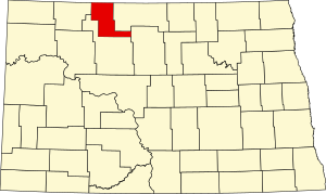
Bottineau County is a county in the U.S. state of North Dakota. As of the 2020 census, the population was 6,379. Its county seat is Bottineau.

<span class="mw-page-title-main">Olivia, Minnesota</span> City in Minnesota, United States

Olivia is the county seat of Renville County, Minnesota, United States. Its population was 2,484 at the 2010 census.

<span class="mw-page-title-main">Bottineau, North Dakota</span> City in North Dakota, United States

Bottineau is a city in Bottineau County, North Dakota, United States. It is the county seat of Bottineau County and is located just over ten miles (16 km) south of the Canada–United States border. The city's population was 2,194 at the 2020 census.

<span class="mw-page-title-main">Gardena, North Dakota</span> City in North Dakota, United States

Gardena is a city in Bottineau County, North Dakota, United States. The population was 24 at the 2020 census. Gardena was founded in 1905.

<span class="mw-page-title-main">Lansford, North Dakota</span> City in North Dakota, United States

Lansford is a city in Bottineau County, North Dakota, United States. The population was 238 at the 2020 census. Lansford was founded in 1903.

<span class="mw-page-title-main">Souris, North Dakota</span> City in North Dakota, United States

Souris is a rural small city in Bottineau County, North Dakota, United States. There is a large granary at Souris, also a bank, post office and bar; but no grocery or gas station. The population was 37 at the 2020 census. Souris was founded in 1901.

<span class="mw-page-title-main">Loraine, North Dakota</span> City in North Dakota, United States

Loraine is a city in Renville County, North Dakota, United States. The population was 9 at the 2020 census. It is part of the Minot Micropolitan Statistical Area.

<span class="mw-page-title-main">Mohall, North Dakota</span> City in North Dakota, United States

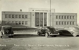
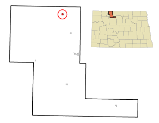
Mohall is a city in Renville County, North Dakota, United States. It is the county seat of Renville County. The population was 694 at the 2020 census. Mohall is part of the Minot Micropolitan Statistical Area.

<span class="mw-page-title-main">Sherwood, North Dakota</span> City in North Dakota, United States

Sherwood is a city in Renville County, North Dakota, United States. The population was 194 as of the 2020 census. It is part of the Minot Micropolitan Statistical Area. It was founded in 1904 and named after Sherwood H. Sleeper, a Mohall banker who had owned land in the area.

<span class="mw-page-title-main">Overly, North Dakota</span> City in North Dakota, United States

Overly is a city in Bottineau County in the U.S. state of North Dakota. The population was 10 at the 2020 census.

<span class="mw-page-title-main">Blaine Township, Bottineau County, North Dakota</span> Township in North Dakota, United States

Blaine Township is a township in Bottineau County in the U.S. state of North Dakota. Its population during the 2000 Census was 30, and an estimated 27 people as of 2009.

References

  1. 1 2 "State & County QuickFacts". United States Census Bureau. Retrieved April 6, 2023.
  2. "Find a County". National Association of Counties. Retrieved June 7, 2011.
  3. Fitzmaurice v. Willis, 127N.W.95 (N.D.1910).
  4. 1 2 "Dakota Territory, South Dakota, and North Dakota: Individual County Chronologies". Dakota Territory Atlas of Historical County Boundaries. The Newberry Library. 2006. Archived from the original on April 2, 2018. Retrieved February 4, 2015.
  5. "County History". Official Portal for North Dakota State Government. Archived from the original on February 2, 2015. Retrieved May 4, 2011.
  6. 1 2 3 4 "Renville County · North Dakota". Google Maps. Retrieved April 27, 2024.
  7. ""Find an Altitude/Renville County ND" Google Maps (accessed February 25, 2019)". Archived from the original on May 21, 2019. Retrieved February 25, 2019.
  8. "2010 Census Gazetteer Files". United States Census Bureau. August 22, 2012. Archived from the original on January 29, 2015. Retrieved February 1, 2015.
  9. "Annual Estimates of the Resident Population for Counties: April 1, 2020 to July 1, 2022" . Retrieved April 6, 2023.
  10. "United States Decennial Census". United States Census Bureau. Retrieved February 1, 2015.
  11. "Historical Census Browser". University of Virginia Library. Retrieved February 1, 2015.
  12. Forstall, Richard L., ed. (April 20, 1995). "Population of Counties by Decennial Census: 1900 to 1990". United States Census Bureau. Retrieved February 1, 2015.
  13. "Census 2000 PHC-T-4. Ranking Tables for Counties: 1990 and 2000" (PDF). United States Census Bureau. April 2, 2001. Archived (PDF) from the original on March 27, 2010. Retrieved February 1, 2015.
  14. Greene, shown on a 1977 USGS map (at present day 46th Ave NW and 86th Street NW), was a station stop on the Minneapolis, St. Paul and Sault Ste. Marie Railroad. Its former streets are still shown on Google Earth and Yahoo! Maps
  15. "Greene, N. Dak". www.thomasgloger.com. Archived from the original on March 4, 2016. Retrieved April 13, 2018.
  16. Leip, David. "Atlas of US Presidential Elections". uselectionatlas.org. Retrieved April 13, 2018.
  17. The leading "other" candidate, Progressive Theodore Roosevelt, received 341 votes, while Socialist Eugene Debs received 224 votes, Prohibition candidate Eugene Chafin received 17 votes.

48°43′N101°40′W / 48.71°N 101.66°W / 48.71; -101.66