Barnes County, North Dakota

Last updated

Barnes County
Barnes County Courthouse 2009.jpg
Map of North Dakota highlighting Barnes County.svg
Location within the U.S. state of North Dakota
North Dakota in United States.svg
North Dakota's location within the U.S.
Coordinates: 46°56′N98°04′W / 46.93°N 98.07°W / 46.93; -98.07
CountryFlag of the United States.svg United States
StateFlag of North Dakota.svg  North Dakota
Founded1872 (created as Burbank)
1874 (renamed as Barnes)
January 6, 1879 (organized)
Named for judge Alanson H. Barnes
Seat Valley City
Largest cityValley City
Area
  Total1,513 sq mi (3,920 km2)
  Land1,492 sq mi (3,860 km2)
  Water22 sq mi (60 km2)  1.4%
Population
 (2020)
  Total10,853
  Estimate 
(2023)
10,726 Decrease2.svg
  Density7.2/sq mi (2.8/km2)
Time zone UTC−6 (Central)
  Summer (DST) UTC−5 (CDT)
Congressional district At-large
Website www.barnescounty.us

Barnes County is a county in the U.S. state of North Dakota. As of the 2020 census, the population was 10,853. [1] Its county seat is Valley City. [2]

Contents

In 1872, the Dakota Territory legislature authorized Burbank County (named for governor John A. Burbank); in 1874 they renamed it Barnes County, for Alanson H. Barnes (1818–1890), an associate justice of the Territorial Court. It was organized at Valley City on January 6, 1879. [3]

Geography

Native vegetation based on NRCS soils information Barnes Co ND Pie Chart No Text Version.pdf
Native vegetation based on NRCS soils information

The Sheyenne River flows southerly through the central part of Barnes County. The county terrain consists of rolling hills, carved with drainages, and dotted with lakes and ponds. The area is largely devoted to agriculture. [4] The terrain slopes to the south and east; its highest point is on its upper west boundary line, at 1,535 ft (468 m) ASL. [5] The county has a total area of 1,513 square miles (3,920 km2), of which 1,492 square miles (3,860 km2) is land and 22 square miles (57 km2) (1.4%) is water. [6]

Major highways

Transit

Adjacent counties

Protected areas

[4]

Lakes

  • Lake Ashtabula
  • Eckelson Lake
  • Fox Lake
  • Goose Lake
  • Hobart Lake
  • Island Lake
  • Kee Lake
  • Lake Benson
  • Meadow Lake
  • Moon Lake
  • Mud Lake
  • Round Lake
  • Saint Marys Lake
  • Sanborn Lake
  • Tomahawk Lake

[4]

Demographics

Historical population
CensusPop.Note
1880 1,585
1890 7,045344.5%
1900 13,15986.8%
1910 18,06637.3%
1920 18,6783.4%
1930 18,8040.7%
1940 17,814−5.3%
1950 16,884−5.2%
1960 16,719−1.0%
1970 14,669−12.3%
1980 13,960−4.8%
1990 12,545−10.1%
2000 11,775−6.1%
2010 11,066−6.0%
2020 10,853−1.9%
2023 (est.)10,726 [7] −1.2%
U.S. Decennial Census [8]
1790-1960 [9] 1900-1990 [10]
1990-2000 [11] 2010-2020 [1]

2020 census

As of the 2020 census, there were 10,853 people, 4,772 households, and 2,751 families in the county. [12] The population density was 7.3 inhabitants per square mile (2.8/km2) There were 5,671 housing units.

2010 census

As of the 2010 census, there were 11,066 people, 4,826 households, and 2,927 families residing in the county. The population density was 7.4 inhabitants per square mile (2.9/km2). There were 5,704 housing units at an average density of 3.8 units per square mile (1.5/km2). The racial makeup of the county was 96.4% white, 0.8% black or African American, 0.7% American Indian, 0.5% Asian, 0.2% from other races, and 1.4% from two or more races. Those of Hispanic or Latino origin made up 1.1% of the population. In terms of ancestry, 48.4% were German, 37.2% were Norwegian, 8.3% were Irish, 5.2% were English, and 2.7% were American.

Of the 4,826 households, 24.8% had children under the age of 18 living with them, 50.8% were married couples living together, 6.4% had a female householder with no husband present, 39.3% were non-families, and 32.9% of all households were made up of individuals. The average household size was 2.19 and the average family size was 2.79. The median age was 44.3 years.

The median income for a household in the county was $41,773 and the median income for a family was $59,558. Males had a median income of $42,575 versus $30,361 for females. The per capita income for the county was $26,152. About 6.4% of families and 12.0% of the population were below the poverty line, including 12.6% of those under age 18 and 14.6% of those age 65 or over.

Population by decade

Barnes County, North Dakota

Communities

Cities

Unincorporated communities

Townships

Notable people

Politics

Barnes County is a reliable bellwether for the state of North Dakota, having voted for the statewide winner in every presidential election since 1896. Like North Dakota as a whole, Barnes County voters have been reliably Republican for decades. In only one national election since 1936 has the county selected the Democratic County candidate.

United States presidential election results for Barnes County, North Dakota [13]
Year Republican Democratic Third party
No.%No.%No.%
2020 3,56864.12%1,82032.70%1773.18%
2016 3,16059.13%1,59729.88%58710.98%
2012 2,96453.68%2,39443.35%1642.97%
2008 2,82649.63%2,74148.14%1272.23%
2004 3,54160.92%2,18637.61%861.48%
2000 3,45260.06%1,93333.63%3636.32%
1996 2,44944.79%2,31742.37%70212.84%
1992 2,72842.30%2,12432.94%1,59724.76%
1988 3,63155.47%2,85843.66%570.87%
1984 4,34862.79%2,50736.20%701.01%
1980 4,39259.79%2,12828.97%82611.24%
1976 4,01153.75%3,32144.51%1301.74%
1972 4,51861.14%2,80437.95%670.91%
1968 3,83156.30%2,62338.55%3515.16%
1964 2,98742.62%4,00757.18%140.20%
1960 4,40357.71%3,22342.25%30.04%
1956 4,47561.99%2,73037.82%140.19%
1952 5,53471.84%2,12027.52%490.64%
1948 3,38551.33%2,89243.86%3174.81%
1944 3,69655.55%2,92243.92%350.53%
1940 4,64957.67%3,38441.97%290.36%
1936 2,32430.00%4,48457.89%93812.11%
1932 2,52732.96%4,83363.04%3074.00%
1928 3,75553.01%3,29346.49%350.49%
1924 3,20551.46%3465.56%2,67742.98%
1920 5,15080.27%1,10117.16%1652.57%
1916 1,46745.08%1,67851.57%1093.35%
1912 57024.72%94040.76%79634.52%
1908 1,78662.06%99634.61%963.34%
1904 2,04176.13%45116.82%1897.05%
1900 1,32453.78%1,07743.74%612.48%

Education

School districts: [14]

Former districts:

See also

Related Research Articles

<span class="mw-page-title-main">Williams County, North Dakota</span> County in North Dakota, United States

Williams County is located on the western border of the U.S. state of North Dakota, next to Montana. As of the 2020 census, the population was 40,950. making it the fifth most populous county in North Dakota. Its county seat is Williston.

<span class="mw-page-title-main">Towner County, North Dakota</span> County in North Dakota, United States

Towner County is a county in the U.S. state of North Dakota. As of the 2020 census, the population is 2,162. Its county seat is Cando. It is south of the Canada–US border with Manitoba.

<span class="mw-page-title-main">Stutsman County, North Dakota</span> County in North Dakota, United States

Stutsman County is a county in the U.S. state of North Dakota. As of the 2020 census, the population was 21,593, making it the 8th most populous county in North Dakota. Its county seat is Jamestown.

<span class="mw-page-title-main">Rolette County, North Dakota</span> County in the United States

Rolette County is a county in the U.S. state of North Dakota. As of the 2020 census, the population was 12,187. Its county seat is Rolla.

<span class="mw-page-title-main">Ransom County, North Dakota</span> County in North Dakota, United States

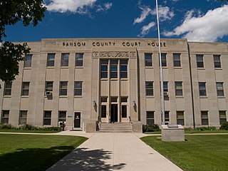
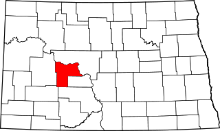
Ransom County is a county in the U.S. state of North Dakota. As of the 2020 census, the population was 5,703. Its county seat is Lisbon.

<span class="mw-page-title-main">Oliver County, North Dakota</span> County in North Dakota, United States

Oliver County is a county located in the U.S. state of North Dakota. As of the 2020 census, the population was 1,877. Its county seat and only city is Center.

<span class="mw-page-title-main">Mercer County, North Dakota</span> County in North Dakota, United States

Mercer County is a county in the U.S. state of North Dakota. As of the 2020 census, the population was 8,350. Its county seat is Stanton.

<span class="mw-page-title-main">McLean County, North Dakota</span> County in North Dakota, United States

McLean County is a county in the U.S. state of North Dakota. As of the 2020 census, the population was 9,771. Its county seat is Washburn.

<span class="mw-page-title-main">Griggs County, North Dakota</span> County in North Dakota, United States

Griggs County is a county in the U.S. state of North Dakota. As of the 2020 census, the population was 2,306. Its county seat is Cooperstown.

<span class="mw-page-title-main">Dunn County, North Dakota</span> County in North Dakota, United States

Dunn County is a county in the U.S. state of North Dakota. As of the 2020 census, the population was 4,095. Its county seat is Manning.

<span class="mw-page-title-main">Cass County, North Dakota</span> County in North Dakota, United States

Cass County is a county in the U.S. state of North Dakota. As of the 2020 census, the population was 184,525. Cass County is the most populous county in North Dakota, accounting for nearly 24% of the state's population. The county seat is Fargo, the state's most populous city. The county is named for George Washington Cass, president of the Northern Pacific Railway from 1872 to 1875. It is the only Cass County in the United States that is not named after Lewis Cass.

<span class="mw-page-title-main">Burleigh County, North Dakota</span> County in North Dakota, United States

Burleigh County is a county in the U.S. state of North Dakota. As of the 2020 census, the population was 98,458, making it the second most populous county in North Dakota. Its county seat is Bismarck, the state capital. The county was named for Dakota Territory political figure Walter A. Burleigh.

<span class="mw-page-title-main">Benson County, North Dakota</span> County in North Dakota, United States

Benson County is a county in the U.S. state of North Dakota. As of the 2020 census, the population was 5,964. Its county seat is Minnewaukan. The county was created on March 9, 1883 by the Dakota Territory legislature, and was named for Bertil W. Benson, a Dakota Territory legislator at the time. The county government was organized on June 4, 1884, and its boundary lines were altered by two legislative actions in 1885.

<span class="mw-page-title-main">Dazey, North Dakota</span> City in North Dakota, United States

Dazey is a city in Barnes County, North Dakota, United States. The population was 78 at the 2020 census. Dazey was founded in 1883 after a local farmer, Charles Dazey, donated land to start a townsite.

<span class="mw-page-title-main">Fingal, North Dakota</span> City in North Dakota, United States

Fingal is a city in Barnes County, North Dakota, United States. The population was 92 at the 2020 census. Fingal was founded in 1891.

<span class="mw-page-title-main">Litchville, North Dakota</span> City in North Dakota, United States

Litchville is a city in Barnes County, North Dakota, United States. The population was 169 at the 2020 census. Litchville was founded in 1900.

<span class="mw-page-title-main">Oriska, North Dakota</span> City in North Dakota, United States

Oriska is a city in Barnes County, North Dakota, United States. The population was 114 at the 2020 census.

<span class="mw-page-title-main">Valley City, North Dakota</span> City in North Dakota, United States

Valley City is a city in and the county seat of Barnes County, North Dakota, United States. The population was 6,575 during the 2020 census, making it the 12th most populous city in North Dakota. Valley City was founded in 1874.

<span class="mw-page-title-main">Buffalo, North Dakota</span> City in North Dakota, United States

Buffalo is a city in Cass County, North Dakota, United States. The population was 195 at the 2020 census. Buffalo was founded in 1878.

<span class="mw-page-title-main">Marion, North Dakota</span> City in North Dakota, United States

Marion is a city in LaMoure County, North Dakota, United States. The population was 125 at the 2020 census.

References

  1. 1 2 "State & County QuickFacts". United States Census Bureau. Retrieved May 8, 2024.
  2. "Find a County". National Association of Counties. Archived from the original on May 31, 2011. Retrieved June 7, 2011.
  3. "County History". North Dakota.gov. The State of North Dakota. Archived from the original on February 2, 2015. Retrieved February 2, 2015.
  4. 1 2 3 Barnes County ND Google Maps (accessed February 13, 2019)
  5. ""Find an Altitude" Barnes County ND - Google Maps (accessed February 13, 2019)". Archived from the original on May 21, 2019. Retrieved February 13, 2019.
  6. "2010 Census Gazetteer Files". United States Census Bureau. August 22, 2012. Archived from the original on January 29, 2015. Retrieved January 27, 2015.
  7. "Annual Estimates of the Resident Population for Counties: April 1, 2020 to July 1, 2023" . Retrieved May 8, 2024.
  8. "United States Decennial Census". United States Census Bureau. Retrieved January 27, 2015.
  9. "Historical Census Browser". University of Virginia Library. Retrieved January 27, 2015.
  10. Forstall, Richard L., ed. (March 27, 1995). "Population of Counties by Decennial Census: 1900 to 1990". United States Census Bureau. Retrieved January 27, 2015.
  11. "Census 2000 PHC-T-4. Ranking Tables for Counties: 1990 and 2000" (PDF). United States Census Bureau. April 2, 2001. Archived (PDF) from the original on March 27, 2010. Retrieved January 27, 2015.
  12. "US Census Bureau, Table P16: Household Type". United States Census Bureau. Retrieved May 8, 2024.
  13. Leip, David. "Atlas of US Presidential Elections". uselectionatlas.org. Retrieved April 12, 2018.
  14. 1 2 3 "2020 CENSUS - SCHOOL DISTRICT REFERENCE MAP: Barnes County, ND" (PDF). United States Census Bureau. Archived (PDF) from the original on August 15, 2021. Retrieved July 24, 2022. - Text list - 2010 map and 2010 text list
  15. 1 2 "Enrollment History Public School Districts 2009-2021". North Dakota Department of Public Instruction . Retrieved August 19, 2021. - Check the 2020-2021 spreadsheet, which lists a single "Hope Page" school district, and compare with all previous sheets which show them as two separate school districts.
  16. "School districts agree to consolidate". The Bismarck Tribune . Associated Press. November 7, 2002. p. 8A. - Clipping from Newspapers.com.

46°56′N98°04′W / 46.93°N 98.07°W / 46.93; -98.07