Nome, North Dakota

Last updated

Nome, North Dakota
Street nome north dakota 2009.jpg
Street in Nome
ND Barnes County Nome.svg
Location of Nome, North Dakota
USA North Dakota location map.svg
Red pog.svg
Nome, North Dakota
Usa edcp location map.svg
Red pog.svg
Nome, North Dakota
Coordinates: 46°40′40″N97°48′46″W / 46.67778°N 97.81278°W / 46.67778; -97.81278
CountryUnited States
State North Dakota
County Barnes
Founded1901
Area
[1]
  Total0.41 sq mi (1.07 km2)
  Land0.41 sq mi (1.07 km2)
  Water0.00 sq mi (0.00 km2)
Elevation
1,339 ft (408 m)
Population
 (2020)
  Total51
  Density123.19/sq mi (47.53/km2)
Time zone UTC-6 (CST)
  Summer (DST) UTC-5 (CDT)
ZIP code
58062
Area code 701
FIPS code 38-57180
GNIS feature ID1030421 [2]

Nome is a city in Barnes County, North Dakota, United States. The population was 51 at the 2020 census. [3] Nome was founded in 1901.

Contents

Geography

Nome is located at 46°40′40″N97°48′46″W / 46.67778°N 97.81278°W / 46.67778; -97.81278 (46.677767, -97.812869). [4]

According to the United States Census Bureau, the city has a total area of 0.41 square miles (1.06 km2), all land. [5]

Demographics

Historical population
CensusPop.Note
1910 218
1920 26722.5%
1930 218−18.4%
1940 27727.1%
1950 217−21.7%
1960 145−33.2%
1970 103−29.0%
1980 67−35.0%
1990 8222.4%
2000 70−14.6%
2010 62−11.4%
2020 51−17.7%
2021 (est.)51 [6] 0.0%
U.S. Decennial Census [7]
2020 Census [3]

Nome is the home of Inter-Community Telephone Company http://ictc.com

2010 census

As of the census of 2010, there were 62 people, 25 households, and 19 families living in the city. The population density was 151.2 inhabitants per square mile (58.4/km2). There were 35 housing units at an average density of 85.4 per square mile (33.0/km2). The racial makeup of the city was 100.0% White.

There were 25 households, of which 28.0% had children under the age of 18 living with them, 68.0% were married couples living together, 4.0% had a female householder with no husband present, 4.0% had a male householder with no wife present, and 24.0% were non-families. 24.0% of all households were made up of individuals, and 12% had someone living alone who was 65 years of age or older. The average household size was 2.48 and the average family size was 2.95.

The median age in the city was 47.5 years. 25.8% of residents were under the age of 18; 3.3% were between the ages of 18 and 24; 19.3% were from 25 to 44; 27.5% were from 45 to 64; and 24.2% were 65 years of age or older. The gender makeup of the city was 54.8% male and 45.2% female.

2000 census

As of the census of 2000, there were 70 people, 31 households, and 20 families living in the city. The population density was 168.8 inhabitants per square mile (65.2/km2). There were 38 housing units at an average density of 91.6 per square mile (35.4/km2). The racial makeup of the city was 95.71% White, and 4.29% from two or more races.

There were 31 households, out of which 29.0% had children under the age of 18 living with them, 58.1% were married couples living together, 3.2% had a female householder with no husband present, and 32.3% were non-families. 32.3% of all households were made up of individuals, and 22.6% had someone living alone who was 65 years of age or older. The average household size was 2.26 and the average family size was 2.86.

In the city, the population was spread out, with 25.7% under the age of 18, 4.3% from 18 to 24, 24.3% from 25 to 44, 14.3% from 45 to 64, and 31.4% who were 65 years of age or older. The median age was 43 years. For every 100 females, there were 100.0 males. For every 100 females age 18 and over, there were 108.0 males.

The median income for a household in the city was $28,500, and the median income for a family was $30,833. Males had a median income of $31,250 versus $16,875 for females. The per capita income for the city was $11,973. There were 7.7% of families and 12.5% of the population living below the poverty line, including 30.0% of under eighteens and 7.7% of those over 64.

Related Research Articles

Koyuk is a city in the Nome Census Area, Alaska, United States. The population was 332 at the 2010 census, up from 297 in 2000.

<span class="mw-page-title-main">Keams Canyon, Arizona</span> CDP in Navajo County, Arizona

Keams Canyon is a census-designated place (CDP) in Navajo County, Arizona, United States, on the Hopi Reservation. The population was 304 at the 2010 census.

<span class="mw-page-title-main">Glasford, Illinois</span> Village in Illinois, United States

Glasford is a village in Peoria County, Illinois, United States. The population was 866 at the 2020 census. Glasford is part of the Peoria, Illinois Metropolitan Statistical Area.

<span class="mw-page-title-main">Dublin, Indiana</span> Town in Indiana, United States

Dublin is a town in Jackson Township, Wayne County, in the U.S. state of Indiana. The population was 679 at the 2020 census.

<span class="mw-page-title-main">Cleghorn, Iowa</span> City in Iowa, United States

Cleghorn is a city in Cherokee County, Iowa, United States. The population was 240 at the 2020 census.

<span class="mw-page-title-main">Hayesville, Iowa</span> City in Iowa, United States

Hayesville is a city in Keokuk County, Iowa, United States. The population was 41 at the time of the 2020 census.

<span class="mw-page-title-main">Webster, Iowa</span> City in Iowa, United States

Webster is a city in Keokuk County, Iowa, United States. The population was 94 at the time of the 2020 census.

<span class="mw-page-title-main">Deer Creek, Minnesota</span> City in Minnesota, United States

Deer Creek is a city in Otter Tail County, Minnesota, United States. The population was 330 at the 2020 census.

<span class="mw-page-title-main">Urbank, Minnesota</span> City in Minnesota, United States

Urbank is a city in Otter Tail County, Minnesota, United States. The population was 52 at the 2020 census.

<span class="mw-page-title-main">St. Rosa, Minnesota</span> City in Minnesota, United States

Saint Rosa is a city in Stearns County, Minnesota, United States. The population was 68 at the 2010 census. It is part of the St. Cloud Metropolitan Statistical Area.

<span class="mw-page-title-main">Velda City, Missouri</span> City in Missouri, United States

Velda City is a city in St. Louis County, Missouri, United States. The population was 1,420 at the 2010 census.

<span class="mw-page-title-main">Harris Hill, New York</span> Census-designated place in New York, United States

Harris Hill is a hamlet and census-designated place (CDP) located in the town of Clarence in Erie County, New York, United States. The population was 5,508 at the 2010 census. It is part of the Buffalo-Niagara Falls metropolitan area. The region is named after Asa Harris, a former officer in the American Colonial Army, who established a tavern near the top of a low hill northeast of Buffalo.

<span class="mw-page-title-main">Kramer, North Dakota</span> City in North Dakota, United States

Kramer is a city in Bottineau County, North Dakota, United States. The population was 24 at the 2020 census. Kramer was founded in 1905.

<span class="mw-page-title-main">Ayr, North Dakota</span> City in North Dakota, United States

Ayr is a city in Cass County, North Dakota, United States. The population was 11 at the 2020 census. Ayr was founded in 1883.

<span class="mw-page-title-main">North River, North Dakota</span> City in North Dakota, United States

North River is a city in Cass County, North Dakota, United States. The population was 55 at the 2020 census. North River was founded in 1973. It is a suburb/bedroom community directly adjacent to the city of Fargo.

<span class="mw-page-title-main">La Bolt, South Dakota</span> Town in South Dakota, United States

La Bolt is a town in Grant County, South Dakota, United States. The population was 66 at the 2020 census.

<span class="mw-page-title-main">Crooks, South Dakota</span> City in South Dakota, United States

Crooks is a city in Minnehaha County, South Dakota, United States and is a suburb of Sioux Falls. The population was 1,362 at the 2020 census. Crooks was named New Hope until 1904. The town's present name honors W. A. Crooks, a local politician.

<span class="mw-page-title-main">Nome, Texas</span> City in Texas, United States

Nome is a city in Jefferson County and Liberty County, Texas, United States. It is located 20 miles west of Beaumont at the intersection of U.S. Highway 90, State Highway 326 and Farm to Market Road 365. The population was 469 at the 2020 census. It is part of the Beaumont–Port Arthur Metropolitan Statistical Area.

<span class="mw-page-title-main">Entiat, Washington</span> City in Washington, United States

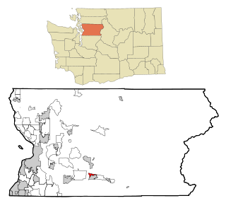
Entiat is a city in Chelan County, Washington, United States. It is part of the Wenatchee−East Wenatchee Metropolitan Statistical Area. The population was 1,326 at the 2020 census.

<span class="mw-page-title-main">North Sultan, Washington</span> CDP in Washington, United States

North Sultan is a census-designated place (CDP) in Snohomish County, Washington, United States. The population was 264 at the 2010 census.

References

  1. "ArcGIS REST Services Directory". United States Census Bureau. Retrieved September 20, 2022.
  2. "US Board on Geographic Names". United States Geological Survey. October 25, 2007. Retrieved January 31, 2008.
  3. 1 2 "Explore Census Data". United States Census Bureau . Retrieved July 21, 2022.
  4. "US Gazetteer files: 2010, 2000, and 1990". United States Census Bureau. February 12, 2011. Retrieved April 23, 2011.
  5. "US Gazetteer files 2010". United States Census Bureau. Archived from the original on January 25, 2012. Retrieved June 14, 2012.
  6. "City and Town Population Totals: 2020-2021". United States Census Bureau. July 21, 2022. Retrieved July 21, 2022.
  7. United States Census Bureau. "Census of Population and Housing" . Retrieved October 31, 2013.