Oliver County, North Dakota

Last updated

Oliver County
Cross Ranch State Park, North Dakota (5069906194).jpg
Map of North Dakota highlighting Oliver County.svg
Location within the U.S. state of North Dakota
North Dakota in United States.svg
North Dakota's location within the U.S.
Coordinates: 47°07′N101°21′W / 47.11°N 101.35°W / 47.11; -101.35
CountryFlag of the United States.svg United States
StateFlag of North Dakota.svg  North Dakota
FoundedApril 14, 1885 (created)
May 18, 1885 (organized)
Named for Harry S. Oliver
Seat Center
Largest cityCenter
Area
  Total731 sq mi (1,890 km2)
  Land723 sq mi (1,870 km2)
  Water8.7 sq mi (23 km2)  1.2%
Population
 (2020)
  Total1,877
  Estimate 
(2022)
1,856 Decrease2.svg
  Density2.6/sq mi (0.99/km2)
Time zone UTC−6 (Central)
  Summer (DST) UTC−5 (CDT)
Congressional district At-large
Website olivercountynd.org

Oliver County is a county located in the U.S. state of North Dakota. As of the 2020 census, the population was 1,877. [1] Its county seat and only city is Center. [2]

Contents

History

The Dakota Territory legislature created the county on April 14, 1885, with territory partitioned from Mercer County. It was named for Harry S. Oliver of Lisbon, North Dakota, a Republican politician and member of the Dakota Territory House of Representatives at the time. The county government was organized on May 18, with Sanger (then known as "Bentley") as county seat. The seat was moved to Center in 1902. [3] [4]

Oliver County is included in the Bismarck, North Dakota Metropolitan Statistical Area.

Geography

The northeastern/eastern boundary of Oliver County is delineated by the Missouri River as it flows southeastward after leaving Lake Sakakawea. The county terrain consists of rolling hills, mostly devoted to agriculture. [5] The terrain slopes to the east, with the highest point a hill near its southwestern corner, at 2,382 ft (726 m) ASL. [6] The county has a total area of 731 square miles (1,890 km2), of which 723 square miles (1,870 km2) is land and 8.7 square miles (23 km2) (1.2%) is water. [7] It is the fifth-smallest county in North Dakota by area.

By sheer coincidence, the county seat, Center, named for being near the geographical center of the county, has also been calculated to be the geographic center of North America. [8]

Major highways

Adjacent counties

Protected areas [5]

Lakes [5]

Demographics

Historical population
CensusPop.Note
1890 464
1900 990113.4%
1910 3,577261.3%
1920 4,42523.7%
1930 4,262−3.7%
1940 3,859−9.5%
1950 3,091−19.9%
1960 2,610−15.6%
1970 2,322−11.0%
1980 2,4957.5%
1990 2,381−4.6%
2000 2,065−13.3%
2010 1,846−10.6%
2020 1,8771.7%
2022 (est.)1,856 [9] −1.1%
U.S. Decennial Census [10]
1790-1960 [11] 1900-1990 [12]
1990-2000 [13] 2010-2020 [1]

2020 census

As of the census of 2020, there were 1,877 people.

2010 census

As of the census of 2010, there were 1,846 people, 756 households, and 554 families in the county. The population density was 2.55 people per square mile (0.98 people/km2). There were 905 housing units at an average density of 1.25 units per square mile (0.48/km2). The racial makeup of the county was 97.3% white, 1.5% American Indian, 0.2% black or African American, 0.2% Asian, 0.2% from other races, and 0.7% from two or more races. Those of Hispanic or Latino origin made up 1.0% of the population. In terms of ancestry, 66.8% were German, 19.3% were Norwegian, 7.6% were Russian, 6.3% were English, and 4.4% were American.

Of the 756 households, 25.0% had children under the age of 18 living with them, 65.5% were married couples living together, 4.8% had a female householder with no husband present, 26.7% were non-families, and 22.6% of all households were made up of individuals. The average household size was 2.44 and the average family size was 2.84. The median age was 47.6 years.

The median income for a household in the county was $62,308 and the median income for a family was $75,069. Males had a median income of $60,592 versus $28,409 for females. The per capita income for the county was $29,348. About 6.5% of families and 9.7% of the population were below the poverty line, including 13.0% of those under age 18 and 19.6% of those age 65 or over.

Population by decade

Oliver County, North Dakota

Communities

City

Unincorporated communities [5]

Politics

Oliver County voters are traditionally Republican. In only one national election since 1936 has the county selected the Democratic Party candidate (as of 2020).

United States presidential election results for Oliver County, North Dakota [14]
Year Republican Democratic Third party
No.%No.%No.%
2020 91886.12%12912.10%191.78%
2016 83081.61%11911.70%686.69%
2012 69368.41%28127.74%393.85%
2008 68265.58%33231.92%262.50%
2004 79070.60%31027.70%191.70%
2000 70967.46%24423.22%989.32%
1996 49948.83%33332.58%19018.59%
1992 50340.96%30624.92%41934.12%
1988 69656.27%52642.52%151.21%
1984 91567.43%41930.88%231.69%
1980 96673.40%27020.52%806.08%
1976 57550.44%52946.40%363.16%
1972 66965.14%29328.53%656.33%
1968 61663.44%26927.70%868.86%
1964 46946.12%54853.88%00.00%
1960 70358.68%49441.24%10.08%
1956 78873.03%27925.86%121.11%
1952 1,13287.82%14311.09%141.09%
1948 74967.84%30427.54%514.62%
1944 75676.83%21922.26%90.91%
1940 1,35683.55%26616.39%10.06%
1936 46929.82%90657.60%19812.59%
1932 30220.56%1,15278.42%151.02%
1928 68051.67%63147.95%50.38%
1924 36732.16%312.72%74365.12%
1920 1,10585.86%1118.62%715.52%
1916 34647.79%32745.17%517.04%
1912 13122.66%13924.05%30853.29%
1908 32562.50%17934.42%163.08%
1904 24181.42%4615.54%93.04%
1900 11058.82%7540.11%21.07%

Education

School districts include: [15]

Center previously had a separate school district, but it merged with Stanton's in 2004. [16]

See also

Related Research Articles

<span class="mw-page-title-main">Albany County, Wyoming</span> County in Wyoming, United States

Albany County is a county in the U.S. state of Wyoming. As of the 2020 United States Census, the population was 37,066. Its county seat is Laramie, the site of the University of Wyoming. Its south border lies on the northern Colorado state line.

<span class="mw-page-title-main">Spink County, South Dakota</span> County in South Dakota, United States

Spink County is a county in the U.S. state of South Dakota. As of the 2020 census, the population was 6,361. Its county seat is Redfield. The county was created in 1873, and was organized in 1879 within Dakota Territory.

<span class="mw-page-title-main">McCook County, South Dakota</span> County in South Dakota, United States

McCook County is a county in the U.S. state of South Dakota. At the 2020 census, the population was 5,682. Its county seat is Salem. The county was established in 1873, and was organized in 1878. It was named for the former governor of the Dakota Territory and Civil War general Edwin Stanton McCook.

<span class="mw-page-title-main">Hughes County, South Dakota</span> County in South Dakota, United States

Hughes County is a county in the U.S. state of South Dakota. As of the 2020 census, the population was 17,765, making it the least populous capital county in the nation, and the 12th most populous county in South Dakota. Its county seat is Pierre, which is also the state capital. The county was created in 1873, and was organized in 1880. It was named for Alexander Hughes, a legislator. On June 4, 1891, the county's area was increased by the addition of Farm Island, in the Missouri River downstream of Pierre.

<span class="mw-page-title-main">Grant County, South Dakota</span> County in South Dakota, United States

Grant County is a county in the U.S. state of South Dakota. As of the 2020 census, the population was 7,556. The county seat is Milbank. The county was founded in 1873 and organized in 1878. It is named for Ulysses S. Grant, 18th President of the United States.

<span class="mw-page-title-main">Buffalo County, South Dakota</span> County in South Dakota, United States

Buffalo County is a county in the U.S. state of South Dakota. As of the 2020 census, the population was 1,948. Its county seat is Gann Valley which, at 10 people, is the least populous county seat in the United States. The county was created in 1864, and was organized in 1871 as part of the Dakota Territory.

<span class="mw-page-title-main">Beadle County, South Dakota</span> County in South Dakota, United States

Beadle County is a county in the U.S. state of South Dakota. As of the 2020 census, the population was 19,149, making it the 11th most populous county in South Dakota. Its county seat is Huron. The county was created in 1879 and organized in 1880. Beadle County comprises the Huron, SD Micropolitan Statistical Area.

<span class="mw-page-title-main">Wells County, North Dakota</span> County in North Dakota, United States

Wells County is a county in the U.S. state of North Dakota. As of the 2020 census, the population was 3,982. Its county seat is Fessenden.

<span class="mw-page-title-main">Towner County, North Dakota</span> County in North Dakota, United States

Towner County is a county in the U.S. state of North Dakota. As of the 2020 census, the population is 2,162. Its county seat is Cando. It is south of the Canada–US border with Manitoba.

<span class="mw-page-title-main">Sioux County, North Dakota</span> County in North Dakota, United States

Sioux County is a county located along the southern border of the U.S. state of North Dakota. As of the 2020 census, the population was 3,898. Its eastern border is the Missouri River and its county seat is Fort Yates.

<span class="mw-page-title-main">Rolette County, North Dakota</span> County in the United States

Rolette County is a county in the U.S. state of North Dakota. As of the 2020 census, the population was 12,187. Its county seat is Rolla.

<span class="mw-page-title-main">Richland County, North Dakota</span> County in North Dakota, United States

Richland County is a county in the far southeast corner of the U.S. state of North Dakota. As of the 2020 census, the population was 16,529. Its county seat is Wahpeton.

<span class="mw-page-title-main">Pierce County, North Dakota</span> County in North Dakota, United States

Pierce County is a county in the U.S. state of North Dakota. As of the 2020 census, the population was 3,990. Its county seat is Rugby.

<span class="mw-page-title-main">Mercer County, North Dakota</span> County in North Dakota, United States

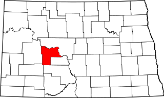
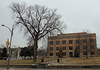
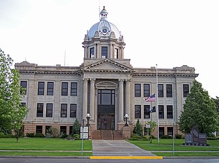
Mercer County is a county in the U.S. state of North Dakota. As of the 2020 census, the population was 8,350. Its county seat is Stanton.

<span class="mw-page-title-main">Griggs County, North Dakota</span> County in North Dakota, United States

Griggs County is a county in the U.S. state of North Dakota. As of the 2020 census, the population was 2,306. Its county seat is Cooperstown.

<span class="mw-page-title-main">Dunn County, North Dakota</span> County in North Dakota, United States

Dunn County is a county in the U.S. state of North Dakota. As of the 2020 census, the population was 4,095. Its county seat is Manning.

<span class="mw-page-title-main">Benson County, North Dakota</span> County in North Dakota, United States

Benson County is a county in the U.S. state of North Dakota. As of the 2020 census, the population was 5,964. Its county seat is Minnewaukan. The county was created on March 9, 1883 by the Dakota Territory legislature, and was named for Bertil W. Benson, a Dakota Territory legislator at the time. The county government was organized on June 4, 1884, and its boundary lines were altered by two legislative actions in 1885.

<span class="mw-page-title-main">Gallatin County, Montana</span> County in Montana, United States

Gallatin County is located in the U.S. state of Montana. With its county seat in Bozeman, it is the second-most populous county in Montana, with a population of 118,960 in the 2020 Census.

<span class="mw-page-title-main">Stanton, North Dakota</span> City in North Dakota, United States

Stanton is a city in Mercer County, North Dakota, United States. It is the county seat of Mercer County. The population was 368 at the 2020 census. Stanton was founded in 1883 and became the county seat when Mercer County organized in 1884.

<span class="mw-page-title-main">Center, North Dakota</span> City in North Dakota, United States

Center is a city in Oliver County, North Dakota, United States. It is the county seat of, and the only incorporated place in, Oliver County. The population was 588 at the 2020 census.

References

  1. 1 2 "U.S. Census Bureau QuickFacts: Oliver County, North Dakota". www.census.gov. United States Census Bureau. Retrieved March 27, 2022.
  2. "Find a County". National Association of Counties. Retrieved June 7, 2011.
  3. "Dakota Territory, South Dakota, and North Dakota: Individual County Chronologies". Dakota Territory Atlas of Historical County Boundaries. The Newberry Library. 2006. Archived from the original on April 2, 2018. Retrieved February 3, 2015.
  4. "County History". Official Portal for North Dakota State Government. Archived from the original on November 16, 2018. Retrieved May 4, 2011.
  5. 1 2 3 4 "Oliver County · North Dakota". Google Maps. Retrieved April 27, 2024.
  6. ""Find an Altitude/Oliver County ND" Google Maps (accessed February 26, 2019)". Archived from the original on May 21, 2019. Retrieved February 27, 2019.
  7. "2010 Census Gazetteer Files". United States Census Bureau. August 22, 2012. Archived from the original on January 29, 2015. Retrieved February 1, 2015.
  8. Hsu, Charlotte. "Where's the center of North America? Geographer's new method finds a new answer". Science Daily. Science Daily. Retrieved January 12, 2017.
  9. "Annual Estimates of the Resident Population for Counties: April 1, 2020 to July 1, 2022" . Retrieved April 5, 2023.
  10. "U.S. Decennial Census". United States Census Bureau. Retrieved February 1, 2015.
  11. "Historical Census Browser". University of Virginia Library. Retrieved February 1, 2015.
  12. Forstall, Richard L., ed. (April 20, 1995). "Population of Counties by Decennial Census: 1900 to 1990". United States Census Bureau. Retrieved February 1, 2015.
  13. "Census 2000 PHC-T-4. Ranking Tables for Counties: 1990 and 2000" (PDF). United States Census Bureau. April 2, 2001. Archived (PDF) from the original on March 27, 2010. Retrieved February 1, 2015.
  14. Leip, David. "Atlas of US Presidential Elections". uselectionatlas.org. Retrieved April 13, 2018.
  15. "2020 CENSUS - SCHOOL DISTRICT REFERENCE MAP: Oliver County, ND" (PDF). United States Census Bureau. Archived (PDF) from the original on August 15, 2021. Retrieved July 24, 2022. - Text list - 2010 map, 2010 text list
  16. Donovan, Lauren (November 12, 2003). "Stanton, Center to join together". Bismarck Tribune . Retrieved August 14, 2021.

47°07′N101°21′W / 47.11°N 101.35°W / 47.11; -101.35