Devils Lake, North Dakota

Last updated

Devils Lake, North Dakota
Downtown Devils Lake.jpg
Downtown Devils Lake
Devils Lake Logo.jpg
ND Ramsey County Devils Lake.svg
Location of Devils Lake, North Dakota
Coordinates: 48°07′47″N98°52′01″W / 48.12972°N 98.86694°W / 48.12972; -98.86694
CountryUnited States
State North Dakota
County Ramsey
Founded1882
Incorporated (village)1884
Incorporated (city)1887
Government
[1]
   Mayor Richard Johnson
Area
[2]
   City 6.96 sq mi (18.04 km2)
  Land6.96 sq mi (18.02 km2)
  Water0.01 sq mi (0.01 km2)
Elevation
[3]
1,437 ft (438 m)
Population
 (2020) [4]
   City 7,192
  Estimate 
(2022) [5]
7,161
  Density1,033.48/sq mi (399.04/km2)
   Urban
7,493
   Metro
11,515
Time zone UTC-6 (Central (CST))
  Summer (DST) UTC-5 (CDT)
ZIP code
58301
Area code 701
FIPS code 38-19420
GNIS feature ID1035989 [3]
Highways US 2, ND 19, ND 20
Website devilslakend.com

Devils Lake is a city in and the county seat of Ramsey County, North Dakota, United States. [6] The population was 7,192 at the 2020 census. [4] It is named after the nearby body of water called Devils Lake. The first house built by an Euro-American settler was in 1882. It was surveyed in 1883 and named Creelsburg and later Creel City, after the surveyor, Heber M. Creel. In 1884 it was renamed Devils Lake. [7]

Contents

The local paper is the Devils Lake Journal . Devils Lake Municipal Airport serves the city. Devils Lake is home to Lake Region State College and the North Dakota School for the Deaf.

History

The present site of Devils Lake was, historically, a territory of the Dakota people. However, the Sisseton, Wahpeton, and Cut-Head bands of the Dakotas were relocated to the Spirit Lake Reservation as a result of the 1867 treaty between the United States and the Dakota that established a reservation for those who had not been forcibly relocated to Crow Creek Reservation in what is now South Dakota. [8] [9] The name "Devils Lake" is a calque of the Dakota phrase mni wak’áŋ (literally translating to spirit water), [10] which is also reflected in the names of the Spirit Lake Tribe and the nearby town of Minnewaukan.

Portrait of Heber M. Creel, c. 1898 Heber M. Creel, circa 1898.jpg
Portrait of Heber M. Creel, c.1898

The Dakota called the lake mni wak’áŋ, which separately translates as mni (water) and wak’áŋ (literally meaning "pure source" but often translated as "spirit" or "sacred"). The European-American settlers misconstrued this name to mean "Bad Spirit Lake" or "Devils Lake." The "bad" referred to the high salinity of the lake, making it unfit to drink, and "spirit" referenced the mirages often seen across the water. The Christian concept of the devil was not present in the Dakota philosophy and religious practices. [11]

The Hidatsa name for the lake is mirixubaash ( meaning "sacred water"). [12]

The first post office was founded November 15, 1882, and was originally named Creelsburg. [7] It was founded by Lieutenant Heber M. Creel, a West Point graduate and topographical engineer stationed at nearby Fort Totten. After resigning from the U.S. Army, he surveyed the land and established the townsite.

The surrounding Creel Township is named for Mr. Creel. The name was later changed to Creel City and expanded by the Great Northern Railway. When the village was incorporated in 1884, the name was changed to City of Devils Lake and then shortened to Devils Lake. [1] [11]

During a period of increased rainfall, beginning in the 1990s and unprecedented in the history of North Dakota, caused the nearby lake, which has no natural outlet, to rise. The surface area has quadrupled, and the higher water has resulted in the moving or destruction of over 400 houses. [13]

Weather Bureau building c. 1900 Wea01360 - Flickr - NOAA Photo Library.jpg
Weather Bureau building c. 1900

Geography and climate

Hydrograph Illustrating rising waters over the 1900-2015 time period. Devils Lake hydrograph.gif
Hydrograph Illustrating rising waters over the 1900–2015 time period.

According to the United States Census Bureau, the city has a total area of 6.51 square miles (16.86 km2), of which 6.50 square miles (16.83 km2) is land and 0.01 square miles (0.03 km2) is water. [14]

Like all of North Dakota, Devils Lake has a humid continental climate (Köppen Dfb) with very cold winters with frequent light snowfall, and warm to very warm, wetter summers with most rain from convective thunderstorms. During the 1936 North American cold wave, the town was one of the coldest places south of the Canada–US border, averaging −21 °F or −29.4 °C for the five weeks ending February 21, 1936 [15] (though at a different site from that now in use). On average 53.4 nights fall to or below 0 °F or −17.8 °C, 104.1 days fail to top freezing, and 184.5 nights fall below 32 °F or 0 °C. In the winter, only 17.5 days on average top freezing, and in severe winters months can pass without even a minor thaw. Extreme heat is rare in summer, with only one day in three years topping 100 °F or 37.8 °C, and only 9.3 topping 90 °F or 32.2 °C.

Climate data for Devils Lake, North Dakota (1971–2000, extremes 1948–2001)
MonthJanFebMarAprMayJunJulAugSepOctNovDecYear
Record high °F (°C)53
(12)
60
(16)
72
(22)
97
(36)
96
(36)
103
(39)
103
(39)
103
(39)
100
(38)
94
(34)
77
(25)
59
(15)
103
(39)
Mean daily maximum °F (°C)14.7
(−9.6)
22.3
(−5.4)
33.6
(0.9)
52.1
(11.2)
67.5
(19.7)
75.3
(24.1)
80.1
(26.7)
79.1
(26.2)
67.7
(19.8)
53.9
(12.2)
33.1
(0.6)
19.4
(−7.0)
49.9
(9.9)
Mean daily minimum °F (°C)−2.5
(−19.2)
5.2
(−14.9)
17.3
(−8.2)
32.2
(0.1)
44.9
(7.2)
54.3
(12.4)
58.6
(14.8)
56.2
(13.4)
46.5
(8.1)
34.6
(1.4)
18.4
(−7.6)
3.6
(−15.8)
30.8
(−0.7)
Record low °F (°C)−36
(−38)
−37
(−38)
−28
(−33)
−12
(−24)
1
(−17)
29
(−2)
39
(4)
33
(1)
20
(−7)
−2
(−19)
−25
(−32)
−37
(−38)
−37
(−38)
Average precipitation inches (mm)0.58
(15)
0.51
(13)
0.80
(20)
0.90
(23)
2.14
(54)
3.83
(97)
3.29
(84)
2.21
(56)
1.80
(46)
1.47
(37)
0.83
(21)
0.57
(14)
18.93
(480)
Average snowfall inches (cm)6.3
(16)
4.7
(12)
6.3
(16)
2.2
(5.6)
0.3
(0.76)
0.0
(0.0)
0.0
(0.0)
0.0
(0.0)
0.0
(0.0)
1.9
(4.8)
5.4
(14)
7.2
(18)
34.3
(87.16)
Average precipitation days (≥ 0.01 inch)8.46.77.27.19.512.110.18.98.47.36.87.499.9
Average snowy days (≥ 0.1 inch)6.23.73.81.10.10.00.00.00.10.73.14.823.6
Source: NOAA [16]

Demographics

Historical population
CensusPop.Note
1890 846
1900 1,729104.4%
1910 5,157198.3%
1920 5,140−0.3%
1930 5,4516.1%
1940 6,20413.8%
1950 6,4273.6%
1960 6,299−2.0%
1970 7,07812.4%
1980 7,4425.1%
1990 7,7824.6%
2000 7,222−7.2%
2010 7,141−1.1%
2020 7,1920.7%
2022 (est.)7,161 [5] −0.4%
U.S. Decennial Census [17]
2020 Census [4]

2010 census

As of the census of 2010, there were 7,141 people, 3,229 households, and 1,712 families living in the city. The population density was 1,098.6 inhabitants per square mile (424.2/km2). There were 3,481 housing units at an average density of 535.5 per square mile (206.8/km2). The racial makeup of the city was 82.9% White, 0.5% African American, 12.5% Native American, 0.4% Asian, 0.3% from other races, and 3.4% from two or more races. Hispanic or Latino of any race were 1.3% of the population.

There were 3,229 households, of which 26.0% had children under the age of 18 living with them, 36.0% were married couples living together, 12.7% had a female householder with no husband present, 4.3% had a male householder with no wife present, and 47.0% were non-families. 41.8% of all households were made up of individuals, and 17.3% had someone living alone who was 65 years of age or older. The average household size was 2.07 and the average family size was 2.80.

The median age in the city was 40.4 years. 21.6% of residents were under the age of 18; 10.9% were between the ages of 18 and 24; 22.3% were from 25 to 44; 26.1% were from 45 to 64; and 19.2% were 65 years of age or older. The gender makeup of the city was 48.1% male and 51.9% female.

2000 census

As of the census of 2000, there were 7,222 people, 3,127 households, and 1,773 families living in the city. The population density was 1,149.4 inhabitants per square mile (443.8/km2). There were 3,508 housing units at an average density of 558.3 per square mile (215.6/km2). The racial makeup of the city was 89.23% White, 0.22% African American, 7.84% Native American, 0.28% Asian, 0.21% from other races, and 2.23% from two or more races. Hispanic or Latino of any race were 0.55% of the population.

The top 6 ancestry groups in the city are German (43.9%), Norwegian (33.4%), Irish (7.6%), French (4.7%), Swedish (4.5%), English (2.7%).

There were 3,127 households, out of which 27.5% had children under the age of 18 living with them, 41.2% were married couples living together, 11.3% had a female householder with no husband present, and 43.3% were non-families. 37.7% of all households were made up of individuals, and 18.0% had someone living alone who was 65 years of age or older. The average household size was 2.18 and the average family size was 2.87.

In the city, the population was spread out, with 24.0% under the age of 18, 10.0% from 18 to 24, 25.6% from 25 to 44, 19.3% from 45 to 64, and 21.1% who were 65 years of age or older. The median age was 38 years. For every 100 females, there were 89.8 males. For every 100 females age 18 and over, there were 85.0 males.

The median income for a household in the city was $31,250, and the median income for a family was $39,541. Males had a median income of $27,972 versus $18,000 for females. The per capita income for the city was $17,741. About 11.2% of families and 16.1% of the population were below the poverty line, including 22.7% of those under age 18 and 8.6% of those age 65 or over.

Education

Public school building in Devils Lake, N.D., 1898 Public school building in Devils Lake, N.D., 1898.jpg
Public school building in Devils Lake, N.D., 1898

K–12

The city of Devils Lake is served by Devils Lake Public Schools. [18] This system operates Sweetwater Elementary School, Prairie View Elementary School, Minnie H Elementary School, Central Middle School, and Devils Lake High School.

A private school, St. Joseph's Catholic School (of the Roman Catholic Diocese of Fargo), is also located in Devils Lake.

Higher education

Sports

Media

Print

Television

Radio

FM

Transportation

Amtrak, the U.S. national passenger rail system, serves Devils Lake, operating its Empire Builder daily in both directions between Chicago and Seattle and Portland, Oregon. SkyWest Air Lines also operates two flights daily to the Devils Lake Municipal Airport from Denver International Airport.

Sites of interest

Notable people

Related Research Articles

<span class="mw-page-title-main">Ramsey County, North Dakota</span> County in North Dakota, United States

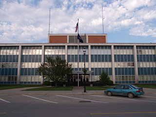
Ramsey County is a county in the U.S. state of North Dakota. As of the 2020 census, the population was 11,605. Its county seat is Devils Lake.

<span class="mw-page-title-main">Benson County, North Dakota</span> County in North Dakota, United States

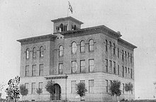
Benson County is a county in the U.S. state of North Dakota. As of the 2020 census, the population was 5,964. Its county seat is Minnewaukan. The county was created on March 9, 1883 by the Dakota Territory legislature, and was named for Bertil W. Benson, a Dakota Territory legislator at the time. The county government was organized on June 4, 1884, and its boundary lines were altered by two legislative actions in 1885.

<span class="mw-page-title-main">Spirit Lake, Iowa</span> City in Iowa, United States

Spirit Lake is a city in Dickinson County, Iowa, United States. The population was 5,439 at the 2020 census. It is the county seat of Dickinson County.

<span class="mw-page-title-main">Fort Totten, North Dakota</span> CDP in North Dakota, United States

Fort Totten is a census-designated place (CDP) in Benson County, North Dakota, United States. The population was 1,243 at the 2010 census. Fort Totten is located within the Spirit Lake Reservation and is the site of tribal headquarters. The reservation has a total population estimated at 6,000. Although not formally incorporated as a city, Fort Totten has the largest population of any community in Benson County.

<span class="mw-page-title-main">Leeds, North Dakota</span> City in North Dakota, United States

Leeds is a city in Benson County, North Dakota, United States. The population was 442 at the 2020 census.

<span class="mw-page-title-main">York, North Dakota</span> City in North Dakota, United States

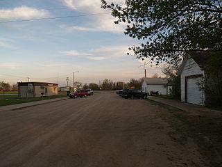
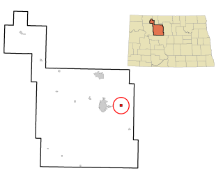
York is a small rural city in Benson County, North Dakota, United States. The population was 17 at the 2020 census. There is a gasoline station there, and a granary, and farm equipment repair services.

<span class="mw-page-title-main">Killdeer, North Dakota</span> City in North Dakota, United States

Killdeer is a city in Dunn County, North Dakota, United States. The population was 939 at the 2020 census.

<span class="mw-page-title-main">Mandaree, North Dakota</span> Census-designated place & Unincorporated community in North Dakota, United States

Mandaree is a census-designated place (CDP) in McKenzie County, North Dakota, United States. The population was 596 at the 2010 census.

<span class="mw-page-title-main">Watford City, North Dakota</span> City in North Dakota, United States

Watford City, founded in 1914, is a city in and the county seat of McKenzie County, North Dakota, United States. The population was 6,207 at the 2020 census, making it the 13th most populous city in North Dakota. Because Watford City is part of the Bakken field, the North Dakota oil boom has significantly increased population and construction since the 2010 census.

<span class="mw-page-title-main">White Shield, North Dakota</span> CDP in North Dakota, United States

White Shield is a census-designated place (CDP) lying within the boundaries of the Mandan, Hidatsa, and Arikara Nation. It is located "on" the Fort Berthold Indian Reservation in McLean County, North Dakota, United States. The population was 336 at the 2010 census. It is considered the primary community of the Arikara (Sahnish) people and is named for Chief White Shield.

<span class="mw-page-title-main">Stanton, North Dakota</span> City in North Dakota, United States

Stanton is a city in Mercer County, North Dakota, United States. It is the county seat of Mercer County. The population was 368 at the 2020 census. Stanton was founded in 1883 and became the county seat when Mercer County organized in 1884.

<span class="mw-page-title-main">New Town, North Dakota</span> City in North Dakota, United States

New Town is a city in Mountrail County, North Dakota. The population was 2,764 at the time of the 2020 census, making it the 18th largest city in North Dakota. New Town was platted in 1950 as a replacement site for the residents of Sanish and Van Hook, as these towns were scheduled to be flooded by the creation of Lake Sakakawea, a reservoir to provide water for irrigation.

<span class="mw-page-title-main">Parshall, North Dakota</span> City in North Dakota, United States

Parshall is a city lying within the jurisdictional boundaries of the Mandan, Hidatsa, and Arikara Nation. It is located on the Fort Berthold Indian Reservation in Mountrail County, North Dakota, United States. The population was 949 at the 2020 census. Parshall was founded in 1914 by George Parshall, and is the home of the Paul Broste Rock Museum.

<span class="mw-page-title-main">Michigan City, North Dakota</span> City in North Dakota, United States

Michigan City is a city in Nelson County, North Dakota, United States. The population was 263 at the 2020 census. Though the official name is Michigan City, local residents commonly refer to the city as Michigan. The town population has been declining since the 1980 census.

<span class="mw-page-title-main">Petersburg, North Dakota</span> City in North Dakota, United States

Petersburg is a city in Nelson County, North Dakota, United States. The population was 162 at the time of the 2020 census.

<span class="mw-page-title-main">Churchs Ferry, North Dakota</span> Unincorporated community and Census Designated Place in North Dakota, United States

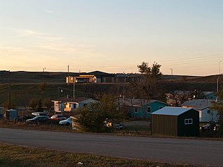
Churchs Ferry is an unincorporated community in Ramsey County, North Dakota, United States that has been impacted by the expansion of nearby Devils Lake. The population was 9 at the 2020 census.

<span class="mw-page-title-main">Crary, North Dakota</span> City in North Dakota, United States

Crary is a city in Ramsey County, North Dakota, United States. The population was 113 at the 2020 census. Crary was founded in 1884 and is named after William Crary, who owned much of the land encompassing the present day community.

<span class="mw-page-title-main">Surrey, North Dakota</span> City in North Dakota, United States

Surrey is a town in Ward County, North Dakota, United States. The population was 1,357 at the 2020 census. Official incorporation of Surrey occurred in 1951. The city is part of the Minot Micropolitan Statistical Area.

<span class="mw-page-title-main">Garretson, South Dakota</span> City in South Dakota, United States

Garretson is a city in Minnehaha County, South Dakota, United States. The city had a population of 1,228 at the 2020 census.

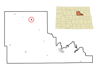
Mission Township is a civil township in Benson County, North Dakota, United States. As of the 2000 census, its population was 1,077. It is the most populous township in the county.

References

  1. 1 2 Wick, Douglas A. (1988). North Dakota Place Names. Bismarck, N.D.: Hedemarken Collectibles. p. 48. ISBN   0-9620968-0-6. OCLC   191277027.
  2. "ArcGIS REST Services Directory". United States Census Bureau. Retrieved September 20, 2022.
  3. 1 2 U.S. Geological Survey Geographic Names Information System: Devils Lake, North Dakota
  4. 1 2 3 "Explore Census Data". United States Census Bureau . Retrieved October 13, 2023.
  5. 1 2 "City and Town Population Totals: 2020-2022". United States Census Bureau. October 13, 2023. Retrieved October 13, 2023.
  6. "Find a County". National Association of Counties. Archived from the original on May 31, 2011. Retrieved June 7, 2011.
  7. 1 2 Ramsey County History Archived October 7, 2006, at the Wayback Machine
  8. http://www.spiritlakenation.com/history/ Spirit Lake Nation 2017, accessed July 5, 2017.
  9. February 19, 1867 "Treaty With the Sioux—Sisseton and Wahpeton Bands, 1867," http://digital.library.okstate.edu/kappler/vol2/treaties/sio0956.htm Archived October 21, 2006, at the Wayback Machine .
  10. Buechel, Eugene. (1970) Lakota-English Dictionary. Pine Ridge, SD: Red Cloud Indian School.
  11. 1 2 Williams, Mary Ann (Barnes) (1966). Origins of North Dakota place names. Bismarck, North Dakota: Bismarck Tribune, 1966. pp. 20, 236. OCLC   431626.
  12. "Hidatsa Lessons Vocab". Hidatsa Language Program. Archived from the original on June 6, 2013. Retrieved July 17, 2012.
  13. "N.D. Monster Lake Swallows Land and Buildings". CBS News. September 22, 2010. Retrieved April 24, 2024.
  14. "US Gazetteer files 2010". United States Census Bureau. Archived from the original on July 2, 2012. Retrieved June 14, 2012.
  15. Kincer, J.B.; ‘Weather Cycle Changing: Present Hard Winter May Be a Foretaste of a Series of Colder and Wetter Years’; The New York Times , February 21, 1936, p. E10
  16. "DEVILS LAKE KDLR (022329) – Climatography of the United States No. 20, 1971–2000" (PDF). National Oceanic and Atmospheric Administration. 2004. Retrieved on August 28, 2015.
  17. "U.S. Decennial Census". Census.gov. Retrieved June 1, 2013.
  18. "2020 CENSUS – SCHOOL DISTRICT REFERENCE MAP: Ramsey County, ND" (PDF). United States Census Bureau . Retrieved August 22, 2021.