Lawton, North Dakota

Last updated

Lawton, North Dakota
Lawton, North Dakota.jpg
The Lawton Fire Department
ND Ramsey County Lawton.svg
Location of Lawton, North Dakota
Coordinates: 48°18′13″N98°22′06″W / 48.30361°N 98.36833°W / 48.30361; -98.36833
CountryUnited States
State North Dakota
County Ramsey
Founded1902
Area
[1]
  Total0.99 sq mi (2.56 km2)
  Land0.91 sq mi (2.36 km2)
  Water0.08 sq mi (0.20 km2)
Elevation
[2]
1,522 ft (464 m)
Population
 (2020)
  Total15
  Density16.45/sq mi (6.35/km2)
Time zone UTC-6 (CST)
  Summer (DST) UTC-5 (CDT)
ZIP code
58345
Area code 701
FIPS code 38-45300
GNIS feature ID1036122 [2]

Lawton is a city in Ramsey County, North Dakota, United States. The population was 15 at the 2020 census. [3] Lawton was founded in 1902.

Contents

Geography

According to the United States Census Bureau, the city has a total area of 1.00 square mile (2.59 km2), of which 0.92 square miles (2.38 km2) is land and 0.08 square miles (0.21 km2) is water. [4]

Demographics

Historical population
CensusPop.Note
1920 227
1930 2332.6%
1940 210−9.9%
1950 2110.5%
1960 159−24.6%
1970 123−22.6%
1980 101−17.9%
1990 63−37.6%
2000 42−33.3%
2010 30−28.6%
2020 15−50.0%
2021 (est.)15 [5] 0.0%
U.S. Decennial Census [6]
2020 Census [3]

2010 census

As of the census of 2010, there were 30 people, 17 households, and 8 families residing in the city. The population density was 32.6 inhabitants per square mile (12.6/km2). There were 33 housing units at an average density of 35.9 per square mile (13.9/km2). The racial makeup of the city was 100.0% White.

There were 17 households, of which 11.8% had children under the age of 18 living with them, 47.1% were married couples living together, and 52.9% were non-families. 35.3% of all households were made up of individuals, and 11.8% had someone living alone who was 65 years of age or older. The average household size was 1.76 and the average family size was 2.13.

The median age in the city was 57 years. 6.7% of residents were under the age of 18; 6.6% were between the ages of 18 and 24; 20% were from 25 to 44; 46.7% were from 45 to 64; and 20% were 65 years of age or older. The gender makeup of the city was 50.0% male and 50.0% female.

2000 census

As of the census of 2000, there were 42 people, 24 households, and 10 families residing in the city. The population density was 45.3 inhabitants per square mile (17.5/km2). There were 38 housing units at an average density of 41.0 per square mile (15.8/km2). The racial makeup of the city was 97.62% White, and 2.38% from two or more races.

There were 24 households, out of which 12.5% had children under the age of 18 living with them, 37.5% were married couples living together, 8.3% had a female householder with no husband present, and 54.2% were non-families. 54.2% of all households were made up of individuals, and 29.2% had someone living alone who was 65 years of age or older. The average household size was 1.75 and the average family size was 2.64.

In the city, the population was spread out, with 14.3% under the age of 18, 2.4% from 18 to 24, 14.3% from 25 to 44, 40.5% from 45 to 64, and 28.6% who were 65 years of age or older. The median age was 52 years. For every 100 females, there were 100.0 males. For every 100 females age 18 and over, there were 89.5 males.

The median income for a household in the city was $14,375, and the median income for a family was $16,875. Males had a median income of $30,625 versus $26,875 for females. The per capita income for the city was $13,752. There were 22.2% of families and 21.4% of the population living below the poverty line, including no under eighteens and 30.0% of those over 64.

Related Research Articles

<span class="mw-page-title-main">Lawton, Iowa</span> City in Iowa, United States

Lawton is a city in Woodbury County, Iowa, Iowa, United States. It is part of the Sioux City metropolitan area. The population was 943 at the time of the 2020 census.

<span class="mw-page-title-main">Hettinger, North Dakota</span> City in North Dakota, United States

Hettinger is a city in, and the county seat of, Adams County, North Dakota, United States. The population was 1,074 at the 2020 census.

<span class="mw-page-title-main">Esmond, North Dakota</span> City in North Dakota, United States

Esmond is a city in Benson County, North Dakota, United States. The population was 91 at the 2020 census. Esmond was founded in 1901.

<span class="mw-page-title-main">Warwick, North Dakota</span> City in North Dakota, United States

Warwick is a city in Benson County, North Dakota, United States. The population was 55 at the 2020 census. Warwick was founded in 1907.

<span class="mw-page-title-main">Kramer, North Dakota</span> City in North Dakota, United States

Kramer is a city in Bottineau County, North Dakota, United States. The population was 24 at the 2020 census. Kramer was founded in 1905.

<span class="mw-page-title-main">Wishek, North Dakota</span> City in North Dakota, United States

Wishek is a city in McIntosh County, North Dakota, United States. The population was 864 at the 2020 census.

<span class="mw-page-title-main">Hoople, North Dakota</span> City in North Dakota, United States

Hoople is a city in Walsh County, North Dakota, United States. The population was 247 at the 2020 census. Hoople, named for early settler Alan Hoople, was founded in 1889. Hoople's nickname is "Tatertown."

<span class="mw-page-title-main">Park River, North Dakota</span> City in North Dakota, United States

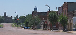
Park River is a city in Walsh County, North Dakota, United States. The population was 1,424 at the 2020 census. Park River was founded in 1884.

<span class="mw-page-title-main">Columbia, South Dakota</span> City in South Dakota, United States

Columbia is an incorporated small town on the James River in Brown County, South Dakota, United States. The population was 160 at the 2020 census. There is a large granary co-op at Columbia, also a post office, a bank, a bar, a church, a town park, and a community center, in addition to the city hall; and many homes.

<span class="mw-page-title-main">Wagner, South Dakota</span> City in South Dakota, United States

Wagner is a city in Charles Mix County, South Dakota, United States. The population was 1,490 at the 2020 census. The city is served by Wagner Municipal Airport as well as YST Transit buses.

<span class="mw-page-title-main">Clear Lake, South Dakota</span> City in South Dakota, United States

Clear Lake is a city in and the county seat of Deuel County, South Dakota, United States. The population was 1,218 at the 2020 census.

<span class="mw-page-title-main">Corsica, South Dakota</span> City in South Dakota, United States

Corsica is a city in Douglas County, South Dakota, United States. The population was 561 at the 2020 census.

<span class="mw-page-title-main">Milbank, South Dakota</span> City in South Dakota, United States

Milbank is a city in Grant County, South Dakota, United States, located along the South Fork of the Whetstone River. The population was 3,544 at the 2020 census. It is the county seat of Grant County. Milbank is the birthplace of American Legion Baseball. The program was created in Milbank in 1925 and is now enjoyed by high school aged youth on more than five thousand teams in all fifty states.

<span class="mw-page-title-main">Parkston, South Dakota</span> City in South Dakota, United States

Parkston is a city in Hutchinson County, South Dakota, United States. The population was 1,567 at the 2020 census.

<span class="mw-page-title-main">Presho, South Dakota</span> City in South Dakota, United States

Presho is a small city in Lyman County, South Dakota, United States. The population was 472 at the 2020 census.

<span class="mw-page-title-main">Leola, South Dakota</span> City in South Dakota, United States

Leola is a small city in, and the county seat of, McPherson County, South Dakota, United States. It was founded on May 1, 1884, and named for Leola Haynes, daughter of one of the town's founders. The population was 434 as of the 2020 census.

<span class="mw-page-title-main">Crooks, South Dakota</span> City in South Dakota, United States

Crooks is a city in Minnehaha County, South Dakota, United States and is a suburb of Sioux Falls. The population was 1,362 at the 2020 census. Crooks was named New Hope until 1904. The town's present name honors W. A. Crooks, a local politician.

<span class="mw-page-title-main">Garretson, South Dakota</span> City in South Dakota, United States

Garretson is a city in Minnehaha County, South Dakota, United States. The city had a population of 1,228 at the 2020 census.

<span class="mw-page-title-main">Hartford, South Dakota</span> City in South Dakota, United States

Hartford is a suburban American city in Minnehaha County, South Dakota, a few miles northwest of Sioux Falls. Its population was 3,354 at the 2020 census.

<span class="mw-page-title-main">Parker, South Dakota</span> City in South Dakota, U.S.

Parker is a city in Turner County, South Dakota, United States. The population was 1,194 at the 2020 census. It is the county seat of Turner County. Parker is bordered on its eastern side by South Dakota State Highway 19. Its northern side is bordered by South Dakota State Highway 44. Parker is located approximately 8 miles (13 km) northwest of Chancellor, 42 miles (68 km) east of Parkston and 41 miles (66 km) south of Madison.

References

  1. "ArcGIS REST Services Directory". United States Census Bureau. Retrieved September 20, 2022.
  2. 1 2 U.S. Geological Survey Geographic Names Information System: Lawton, North Dakota
  3. 1 2 "Explore Census Data". United States Census Bureau . Retrieved May 14, 2022.
  4. "US Gazetteer files 2010". United States Census Bureau. Archived from the original on July 2, 2012. Retrieved June 14, 2012.
  5. "City and Town Population Totals: 2020-2021". United States Census Bureau. July 16, 2022. Retrieved July 16, 2022.
  6. United States Census Bureau. "Census of Population and Housing" . Retrieved February 15, 2014.