Grant County, North Dakota

Last updated

Grant County
Carson Roller Mill.jpg
Map of North Dakota highlighting Grant County.svg
Location within the U.S. state of North Dakota
North Dakota in United States.svg
North Dakota's location within the U.S.
Coordinates: 46°22′N101°38′W / 46.36°N 101.64°W / 46.36; -101.64
CountryFlag of the United States.svg United States
StateFlag of North Dakota.svg  North Dakota
Founded1916
Named for Ulysses S. Grant
Seat Carson
Largest city Elgin
Area
  Total1,666 sq mi (4,310 km2)
  Land1,659 sq mi (4,300 km2)
  Water6.8 sq mi (18 km2)  0.4%
Population
 (2020)
  Total2,301
  Estimate 
(2022)
2,243 Decrease2.svg
  Density1.4/sq mi (0.53/km2)
Time zone UTC−7 (Mountain)
  Summer (DST) UTC−6 (MDT)
Congressional district At-large
Website www.grantcountynd.com

Grant County is a county in the U.S. state of North Dakota. As of the 2020 census, the population was 2,301. [1] Its county seat is Carson. [2]

Contents

History

The territory of Grant County was part of Morton County until 1916. On November 7 the county voters determined that the SW portion of the county would be partitioned off to form a new county, to be named after Ulysses S. Grant, the US President from 1869 to 1877. Accordingly, the county government was organized on November 28, with Carson as the seat. The county's boundaries have remained unchanged since its creation. [3] [4] [5]

Outline map of Grant County, North Dakota, 1918 Map of Grant County, N.D., 1918.jpg
Outline map of Grant County, North Dakota, 1918

Geography

Heart Butte is a prominent geographic feature in Grant County, and the namesake for the nearby Heart Butte Dam. Heart Butte.jpg
Heart Butte is a prominent geographic feature in Grant County, and the namesake for the nearby Heart Butte Dam.

The Heart River flows eastward through the upper part of Grant County, and Cedar Creek flows east-northeastward along the county's southern boundary line. The county terrain consists of isolated hills among rolling hills, carved by drainages. The semi-arid ground is partially devoted to agriculture. [6] The terrain slopes to the east and south; its highest point is a rise near its southwestern corner, at 2,680 ft (820 m) ASL. [7] The county has a total area of 1,666 square miles (4,310 km2), of which 1,659 square miles (4,300 km2) is land and 6.8 square miles (18 km2) (0.4%) is water. [8] Lake Tschida, a Bureau of Reclamation reservoir and recreation area on the Heart River, is the county's largest body of water. [9]

The southwestern corner of North Dakota observes Mountain Time (Adams, Billings, Bowman, Golden Valley, Grant, Hettinger, Slope, and Stark counties). The counties of McKenzie, Dunn, and Sioux counties are split, with the western portions of each observing Mountain Time.

Major highways

Adjacent counties

Protected areas

Source: [6]

Lakes

Source: [6]

Demographics

Historical population
CensusPop.Note
1920 9,553
1930 10,1346.1%
1940 8,264−18.5%
1950 7,114−13.9%
1960 6,248−12.2%
1970 5,009−19.8%
1980 4,274−14.7%
1990 3,549−17.0%
2000 2,841−19.9%
2010 2,394−15.7%
2020 2,301−3.9%
2022 (est.)2,243 [10] −2.5%
U.S. Decennial Census [11]
1790-1960 [12] 1900-1990 [13]
1990-2000 [14] 2010-2020 [1]

2020 census

As of the census of 2020, there were 2,301 people.

2010 census

As of the census of 2010, there were 2,394 people, 1,128 households, and 694 families in the county. The population density was 1.4 inhabitants per square mile (0.54/km2). There were 1,690 housing units at an average density of 1.02 units per square mile (0.39/km2). The racial makeup of the county was 97.2% white, 1.1% American Indian, 0.1% Asian, 0.2% from other races, and 1.3% from two or more races. Those of Hispanic or Latino origin made up 0.3% of the population. In terms of ancestry, 66.6% were German, 14.0% were Norwegian, 12.5% were Russian, 5.9% were Irish, 5.5% were English, and 2.2% were American.

Of the 1,128 households, 19.6% had children under the age of 18 living with them, 54.7% were married couples living together, 3.9% had a female householder with no husband present, 38.5% were non-families, and 36.5% of all households were made up of individuals. The average household size was 2.10 and the average family size was 2.72. The median age was 51.7 years.

The median income for a household in the county was $39,500 and the median income for a family was $53,542. Males had a median income of $33,750 versus $27,303 for females. The per capita income for the county was $25,840. About 7.3% of families and 13.0% of the population were below the poverty line, including 18.1% of those under age 18 and 18.7% of those age 65 or over.

Population by decade

Grant County, North Dakota

Communities

Cities

Census-designated places

Unincorporated communities

Townships

Defunct township

Politics

Grant County voters have traditionally voted Republican. In no national election since 1936 has the county selected the Democratic Party candidate.

United States presidential election results for Grant County, North Dakota [16]
Year Republican Democratic Third party
No.%No.%No.%
2020 1,14582.91%20714.99%292.10%
2016 1,10880.23%18513.40%886.37%
2012 1,02572.54%33423.64%543.82%
2008 87364.91%40530.11%674.98%
2004 95276.65%26421.26%262.09%
2000 1,07775.47%23516.47%1158.06%
1996 76055.51%30021.91%30922.57%
1992 90045.94%41521.18%64432.87%
1988 1,35166.13%65432.01%381.86%
1984 1,60774.92%50723.64%311.45%
1980 1,89180.85%31713.55%1315.60%
1976 1,20553.37%95242.16%1014.47%
1972 1,56970.17%59626.65%713.18%
1968 1,64871.78%48821.25%1606.97%
1964 1,42157.11%1,06342.73%40.16%
1960 1,79465.21%95534.71%20.07%
1956 1,87272.03%71827.63%90.35%
1952 2,46585.32%40313.95%210.73%
1948 1,55566.94%68929.66%793.40%
1944 1,74580.64%41018.95%90.42%
1940 2,81581.52%62718.16%110.32%
1936 1,02229.57%1,85853.76%57616.67%
1932 65717.98%2,91279.69%852.33%
1928 1,75954.59%1,43444.51%290.90%
1924 1,12039.07%1254.36%1,62256.57%
1920 2,18483.17%29611.27%1465.56%

See also

Related Research Articles

<span class="mw-page-title-main">Adams County, North Dakota</span> County in North Dakota, United States

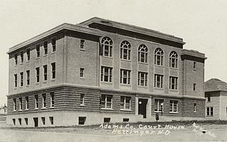
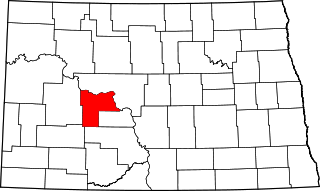
Adams County is a county in the U.S. state of North Dakota. As of the 2020 census, the population was 2,200. The county seat is Hettinger. The county was created on April 17, 1907, and organized one week later. It was named for John Quincy Adams (1848–1919), a railroad official for the Milwaukee Road Railroad and distant relative of sixth U.S. President John Quincy Adams (1767–1848).

<span class="mw-page-title-main">Williams County, North Dakota</span> County in North Dakota, United States

Williams County is located on the western border of the U.S. state of North Dakota, next to Montana. As of the 2020 census, the population was 40,950. making it the fifth most populous county in North Dakota. Its county seat is Williston.

<span class="mw-page-title-main">Stark County, North Dakota</span> County in North Dakota, United States

Stark County is a county in the U.S. state of North Dakota. As of the 2020 census, the population was 33,646, making it the 7th most populous county in North Dakota. Its county seat is Dickinson.

<span class="mw-page-title-main">Slope County, North Dakota</span> County in North Dakota, United States

Slope County is a county in the U.S. state of North Dakota. As of the 2020 census, the population was 706, making it the least populous county in North Dakota and the 18th-least populous county in the United States. The county seat is Amidon.

<span class="mw-page-title-main">Sioux County, North Dakota</span> County in North Dakota, United States

Sioux County is a county located along the southern border of the U.S. state of North Dakota. As of the 2020 census, the population was 3,898. Its eastern border is the Missouri River and its county seat is Fort Yates.

<span class="mw-page-title-main">Morton County, North Dakota</span> County in North Dakota, United States

Morton County is a county in the U.S. state of North Dakota. As of the 2020 census, the population was 33,291, making it the sixth most populous county in North Dakota. Its county seat is Mandan. Morton County is included in the Bismarck, ND, Metropolitan Statistical Area.

<span class="mw-page-title-main">Mercer County, North Dakota</span> County in North Dakota, United States

Mercer County is a county in the U.S. state of North Dakota. As of the 2020 census, the population was 8,350. Its county seat is Stanton.

<span class="mw-page-title-main">McKenzie County, North Dakota</span> County in North Dakota, United States

McKenzie County is a county in the U.S. state of North Dakota. As of the 2020 census, the population was 14,704. Its county seat is Watford City.

<span class="mw-page-title-main">Hettinger County, North Dakota</span> County in North Dakota, United States

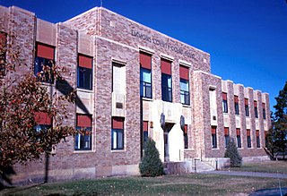
Hettinger County is a county in the U.S. state of North Dakota. As of the 2020 census, the population was 2,489. Its county seat is Mott.

<span class="mw-page-title-main">Golden Valley County, North Dakota</span> County in North Dakota, United States

Golden Valley County is a county in the U.S. state of North Dakota. As of the 2020 census, the population was 1,736, making it the fourth-least populous county in North Dakota. The county seat is Beach.

<span class="mw-page-title-main">Emmons County, North Dakota</span> County in North Dakota, United States

Emmons County is a county in the U.S. state of North Dakota. As of the 2020 census, the population was 3,301. Its county seat has been Linton since 1899.

<span class="mw-page-title-main">Burleigh County, North Dakota</span> County in North Dakota, United States

Burleigh County is a county in the U.S. state of North Dakota. As of the 2020 census, the population was 98,458, making it the second most populous county in North Dakota. Its county seat is Bismarck, the state capital. The county was named for Dakota Territory political figure Walter A. Burleigh.

<span class="mw-page-title-main">Bottineau County, North Dakota</span> County in North Dakota, United States

Bottineau County is a county in the U.S. state of North Dakota. As of the 2020 census, the population was 6,379. Its county seat is Bottineau.

<span class="mw-page-title-main">Hettinger, North Dakota</span> City in North Dakota, United States

Hettinger is a city in, and the county seat of, Adams County, North Dakota, United States. The population was 1,074 at the 2020 census.

<span class="mw-page-title-main">Leith, North Dakota</span> City in North Dakota, United States

Leith is a city in Grant County, North Dakota, United States. The population was 28 at the 2020 census.

<span class="mw-page-title-main">Mott, North Dakota</span> City in North Dakota, United States

Mott is a city in and the county seat of Hettinger County, North Dakota, United States. The population was 653 at the 2020 census.

<span class="mw-page-title-main">New England, North Dakota</span> City in North Dakota, United States

New England is a city in Hettinger County, North Dakota, United States. The population was 683 at the 2020 census.

<span class="mw-page-title-main">Regent, North Dakota</span> City in North Dakota, United States

Regent is a city in Hettinger County, North Dakota, United States. The population was 170 at the 2020 census.

<span class="mw-page-title-main">Garrison, North Dakota</span> City in North Dakota, United States

Garrison is a city in McLean County, North Dakota, United States. The population was 1,462 at the 2020 census.

<span class="mw-page-title-main">Wilton, North Dakota</span> City in North Dakota, United States

Wilton is a city in Burleigh and McLean counties in North Dakota, United States. It is part of the "Bismarck, ND Metropolitan Statistical Area" or "Bismarck-Mandan". The population was 718 at the 2020 census. Founded in 1899, Wilton was named by General W. D. Washburn after the town of Wilton in his native state of Maine.

References

  1. 1 2 "State & County QuickFacts". United States Census Bureau. Retrieved April 6, 2023.
  2. "Find a County". National Association of Counties. Archived from the original on May 31, 2011. Retrieved June 7, 2011.
  3. Long, John H. (2006). "Dakota Territory, South Dakota, and North Dakota: Individual County Chronologies". Dakota Territory Atlas of Historical County Boundaries. The Newberry Library. Archived from the original on November 11, 2007. Retrieved February 19, 2019.
  4. Certification of the division of Morton County, ND 28 November 1916 Archived July 3, 2008, at the Wayback Machine
  5. "County History". North Dakota.gov. The State of North Dakota. Archived from the original on February 2, 2015. Retrieved February 19, 2019.
  6. 1 2 3 4 5 Grant County ND Google Maps (accessed February 19, 2019)
  7. ""Find an Altitude/Grant County ND" Google Maps (accessed February 19, 2019)". Archived from the original on May 21, 2019. Retrieved February 20, 2019.
  8. "2010 Census Gazetteer Files". United States Census Bureau. August 22, 2012. Archived from the original on January 29, 2015. Retrieved January 28, 2015.
  9. "Heart Butte Reservoir". Recreation.gov. Bureau of Reclamation. Retrieved June 3, 2010.
  10. "Annual Estimates of the Resident Population for Counties: April 1, 2020 to July 1, 2022". Census.gov . Retrieved April 6, 2023.
  11. "U.S. Decennial Census". United States Census Bureau. Retrieved January 28, 2015.
  12. "Historical Census Browser". University of Virginia Library. Archived from the original on August 11, 2012. Retrieved January 28, 2015.
  13. Forstall, Richard L., ed. (March 27, 1995). "Population of Counties by Decennial Census: 1900 to 1990". United States Census Bureau. Retrieved January 28, 2015.
  14. "Census 2000 PHC-T-4. Ranking Tables for Counties: 1990 and 2000" (PDF). United States Census Bureau. April 2, 2001. Archived (PDF) from the original on March 27, 2010. Retrieved January 28, 2015.
  15. "Geographic Change Notes for North Dakota". United States Census Bureau. Archived from the original (TXT) on October 10, 2012. Retrieved June 17, 2010.
  16. Leip, David. "Atlas of US Presidential Elections". uselectionatlas.org. Retrieved April 12, 2018.

Further reading

Kane, Joseph Nathan; Charles Curry Aiken (2004). The American Counties: Origins of County Names, Dates of Creation, and Population Data, 1950-2000 . Scarecrow Press. p.  116. ISBN   0-8108-5036-2.

46°22′N101°38′W / 46.36°N 101.64°W / 46.36; -101.64