Carrington, North Dakota

Last updated

Carrington, North Dakota
Carrington ND - grain elevators.jpg
Grain Elevator in Carrington
Nickname: 
Central City
ND Foster County Carrington.svg
Location of Carrington, North Dakota
Coordinates: 47°27′05″N99°07′26″W / 47.45139°N 99.12389°W / 47.45139; -99.12389
CountryUnited States
State North Dakota
County Foster
Founded1883
Government
  MayorNeil Fandrich
Area
[1]
  Total2.37 sq mi (6.15 km2)
  Land2.37 sq mi (6.14 km2)
  Water0.00 sq mi (0.01 km2)
Elevation
[2]
1,585 ft (483 m)
Population
 (2020)
  Total2,080
  Density877.27/sq mi (338.73/km2)
Time zone UTC-6 (CST)
  Summer (DST) UTC-5 (CDT)
ZIP code
58421
Area code 701
FIPS code 38-12340
GNIS feature ID1035955 [2]
Highways US 52, US 281, ND 200
Website carringtonnd.com

Carrington is a city in Foster County, North Dakota, United States. It is the county seat of Foster County. A part of Carrington Township and Wyard Township [3] The population was 2,080 at the 2020 census. [4] Carrington was founded in 1883.

Contents

Carrington is home to Dakota Growers Pasta Company, Inc.

History

Carrington was platted in 1882 by M. D. Carrington, and named for him. [5] Carrington has been the county seat since 1883. [6] A post office has been in operation at Carrington since 1883. [7]

Geography

According to the United States Census Bureau, the city has a total area of 2.11 square miles (5.46 km2), all land. [8]

Demographics

Historical population
CensusPop.Note
1910 1,217
1920 1,42016.7%
1930 1,71720.9%
1940 1,8507.7%
1950 2,10113.6%
1960 2,43816.0%
1970 2,4912.2%
1980 2,6416.0%
1990 2,267−14.2%
2000 2,2680.0%
2010 2,065−9.0%
2020 2,0800.7%
2021 (est.)2,053 [9] −1.3%
U.S. Decennial Census [10]
2020 Census [4]

2010 census

As of the census [11] of 2010, there were 2,065 people, 951 households, and 540 families living in the city. The population density was 978.7 inhabitants per square mile (377.9/km2). There were 1,057 housing units at an average density of 500.9 per square mile (193.4/km2). The racial makeup of the city was 98.1% White, 0.1% African American, 0.7% Native American, 0.1% Asian, 0.1% from other races, and 0.8% from two or more races. Hispanic or Latino of any race were 0.7% of the population.

There were 951 households, of which 22.5% had children under the age of 18 living with them, 47.3% were married couples living together, 6.3% had a female householder with no husband present, 3.2% had a male householder with no wife present, and 43.2% were non-families. 38.5% of all households were made up of individuals, and 19.5% had someone living alone who was 65 years of age or older. The average household size was 2.11 and the average family size was 2.81.

The median age in the city was 46 years. 21.7% of residents were under the age of 18; 6.2% were between the ages of 18 and 24; 20.7% were from 25 to 44; 26.8% were from 45 to 64; and 24.8% were 65 years of age or older. The gender makeup of the city was 48.2% male and 51.8% female.

2000 census

As of the census of 2000, there were 2,268 people, 961 households, and 594 families living in the city. The population density was 1,531.9 inhabitants per square mile (591.5/km2). There were 1,057 housing units at an average density of 713.9 per square mile (275.6/km2). The racial makeup of the city was 98.81% White, 0.18% African American, 0.49% Native American, 0.09% from other races, and 0.44% from two or more races. Hispanic or Latino of any race were 0.22% of the population.

There were 961 households, out of which 31.0% had children under the age of 18 living with them, 50.8% were married couples living together, 8.4% had a female householder with no husband present, and 38.1% were non-families. 35.6% of all households were made up of individuals, and 18.3% had someone living alone who was 65 years of age or older. The average household size was 2.27 and the average family size was 2.97.

In the city, the population was spread out, with 25.4% under the age of 18, 6.0% from 18 to 24, 26.8% from 25 to 44, 18.7% from 45 to 64, and 23.1% who were 65 years of age or older. The median age was 40 years. For every 100 females, there were 90.6 males. For every 100 females age 18 and over, there were 87.3 males.

The median income for a household in the city was $31,197, and the median income for a family was $41,654. Males had a median income of $31,250 versus $19,722 for females. The per capita income for the city was $19,012. About 7.0% of families and 8.9% of the population were below the poverty line, including 10.8% of those under age 18 and 11.0% of those age 65 or over.

Local media

Print

AM Radio

AM radio stations
FrequencyCall signNameFormatOwnerCity
1600 AM KDAK Dakota Country Radio Full service/Country Ingstad Family MediaCarrington

Television

Midcontinent Communications provides cable service to the city of Carrington [12] [13] and New Rockford. Dakota Central Telecommunications provides cable service to Carrington, Jamestown, and other nearby communities.

Education

The city of Carrington is served by Carrington Elementary School and Carrington High School. Prairie View Adventist School is also in Carrington.

Transportation

Two federal highways pass through Carrington. U.S. 281 runs north to south through the area. U.S. 52 runs east and west, co-signed with ND 200 and to U.S. 281, then runs northwest and southeast route. ND 200 runs east and west through the area.

Highways that run through Carrington include U.S. 52, U.S. 281, ND 200 and Foster County CR 1605. The city is also served by both the Canadian Pacific Railway and the Red River Valley and Western Railroad.

Major roads and streets

North and south

  • 4th Avenue U.S. Route 281 (City Park, Crossroads Golf Course, residential, commercial, industrial)
  • 11th Avenue (North of Main Street) (residential, commercial, industrial)
  • 13th Avenue (South of Main Street) (residential, industrial)
  • 14th Avenue (South of Main Street) (residential, industrial)
  • 66th Avenue SE19th Avenue (Old Hwy 281) (Foster County Fairgrounds, industrial)

East and west

  • 11th Street North (Dakota Growers, industrial)
  • Highway 200 Carrington Airport, residential, commercial, industrial)
  • Main Street (Carrington High School, residential, central business district, commercial, industrial)
  • 3rd Street South (City Park, Stadium of 76, Foster County Fairgrounds, residential)
  • 7th Street South (residential, industrial)

Notable people

Climate

This climatic region is typified by large seasonal temperature differences, with warm to hot (and often humid) summers and cold (sometimes severely cold) winters. According to the Köppen Climate Classification system, Carrington has a humid continental climate, abbreviated "Dfb" on climate maps. [14]

Climate data for Carrington 4 N, North Dakota (1991–2020 normals, extremes 1967–present)
MonthJanFebMarAprMayJunJulAugSepOctNovDecYear
Record high °F (°C)55
(13)
58
(14)
76
(24)
99
(37)
97
(36)
103
(39)
107
(42)
107
(42)
105
(41)
92
(33)
78
(26)
61
(16)
107
(42)
Average high °F (°C)18.3
(−7.6)
23.1
(−4.9)
35.8
(2.1)
53.2
(11.8)
67.2
(19.6)
76.4
(24.7)
81.7
(27.6)
80.7
(27.1)
71.8
(22.1)
55.2
(12.9)
37.1
(2.8)
22.8
(−5.1)
51.9
(11.1)
Daily mean °F (°C)8.4
(−13.1)
12.6
(−10.8)
25.6
(−3.6)
41.0
(5.0)
54.6
(12.6)
64.8
(18.2)
69.5
(20.8)
67.5
(19.7)
58.5
(14.7)
43.6
(6.4)
27.5
(−2.5)
13.9
(−10.1)
40.6
(4.8)
Average low °F (°C)−1.5
(−18.6)
2.1
(−16.6)
15.3
(−9.3)
28.7
(−1.8)
41.9
(5.5)
53.3
(11.8)
57.3
(14.1)
54.4
(12.4)
45.3
(7.4)
31.9
(−0.1)
17.9
(−7.8)
5.0
(−15.0)
29.3
(−1.5)
Record low °F (°C)−38
(−39)
−39
(−39)
−26
(−32)
−12
(−24)
14
(−10)
29
(−2)
34
(1)
28
(−2)
15
(−9)
−3
(−19)
−27
(−33)
−37
(−38)
−39
(−39)
Average precipitation inches (mm)0.53
(13)
0.42
(11)
0.75
(19)
1.25
(32)
2.76
(70)
3.78
(96)
3.60
(91)
2.33
(59)
1.97
(50)
1.90
(48)
0.67
(17)
0.81
(21)
20.77
(528)
Average precipitation days (≥ 0.01 in)5.05.24.56.09.710.39.37.76.16.74.55.880.8
Source: NOAA [15] [16]

Related Research Articles

<span class="mw-page-title-main">Pierre, South Dakota</span> Capital city of South Dakota, United States

Pierre is the capital city of the U.S. state of South Dakota and the seat of Hughes County. The population was 14,091 at the 2020 census, making it the second-least populous US state capital after Montpelier, Vermont. It is South Dakota's ninth-most populous city. Founded in 1880, it was selected as the state capital when the territory was admitted as a state. Pierre is the principal city of the Pierre Micropolitan Statistical Area, which includes all of Hughes and Stanley counties.

<span class="mw-page-title-main">Foster County, North Dakota</span> County in North Dakota, United States

Foster County is a county in the U.S. state of North Dakota. As of the 2020 census, the population was 3,397. Its county seat is Carrington.

<span class="mw-page-title-main">Hettinger, North Dakota</span> City in North Dakota, United States

Hettinger is a city in, and the county seat of, Adams County, North Dakota, United States. The population was 1,074 at the 2020 census.

<span class="mw-page-title-main">Bowman, North Dakota</span> City in North Dakota, United States

Bowman is a city and county seat of Bowman County, North Dakota, United States. The population was 1,470 at the 2020 census.

<span class="mw-page-title-main">Scranton, North Dakota</span> City in North Dakota, United States

Scranton is a small town in Bowman County, North Dakota, United States. The population was 258 at the 2020 census.

<span class="mw-page-title-main">Ellendale, North Dakota</span> City in North Dakota, United States

Ellendale is a city in Dickey County, North Dakota, United States. It is the capital city of Dickey County. The population was 1,125 at the 2020 census. Ellendale was founded in 1882. Ellendale is the home of Trinity Bible College, located on the former campus of the North Dakota State Normal and Industrial School and the Ellendale Opera House currently under renovation.

<span class="mw-page-title-main">Crosby, North Dakota</span> City in North Dakota

Crosby is a city and the county seat of Divide County, North Dakota, United States. The population was 1,065 at the 2020 census.

<span class="mw-page-title-main">New Rockford, North Dakota</span> City in North Dakota, United States

New Rockford is a city in Eddy County, North Dakota, United States. It is the county seat of Eddy County. The population was 1,361 at the 2020 census. New Rockford was founded in 1883.

<span class="mw-page-title-main">McHenry, North Dakota</span> City in North Dakota, United States

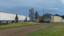
McHenry is a city in Foster County, North Dakota, United States. The population was 64 at the 2020 census. McHenry was founded in 1899.

<span class="mw-page-title-main">Larimore, North Dakota</span> City in North Dakota, United States

Larimore is a city in Grand Forks County, North Dakota, United States. It is located three miles south of the junction of U.S. Route 2 and North Dakota Highway 18. Larimore is part of the "Grand Forks, ND-MN Metropolitan Statistical Area" or "Greater Grand Forks". The population was 1,260 at the 2020 census.

<span class="mw-page-title-main">Jud, North Dakota</span> City in North Dakota, United States

Jud is a rural hamlet in LaMoure County, North Dakota, United States. The population was 65 at the 2020 census. Jud was founded in 1904 and named for county settler Judson LaMoure. It is located along unpaved 61st Street SE, 9 miles (14 km) west of U.S. Route 281 and 25 miles (40 km) south of Interstate 94 in the midst of settled farmland and open plains.

<span class="mw-page-title-main">Wishek, North Dakota</span> City in North Dakota, United States

Wishek is a city in McIntosh County, North Dakota, United States. The population was 864 at the 2020 census.

<span class="mw-page-title-main">Lisbon, North Dakota</span> City in North Dakota, United States

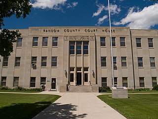
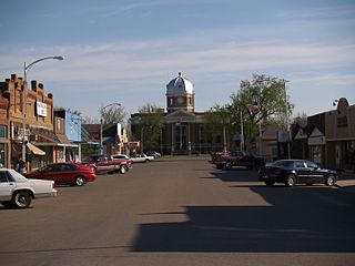
Lisbon is a city in and the county seat of Ransom County, North Dakota, United States. The population was 2,204 at the 2020 census.

<span class="mw-page-title-main">Hankinson, North Dakota</span> City in North Dakota, United States

Hankinson is a city in Richland County, North Dakota, United States. The population was 921 at the 2020 census. Hankinson was founded in 1886. It is part of the Wahpeton, ND–MN Micropolitan Statistical Area.

<span class="mw-page-title-main">Dunseith, North Dakota</span> City in North Dakota, United States

Dunseith is a city in Rolette County, North Dakota, United States. The population was 632 at the 2020 census. Dunseith is best known for its proximity to the International Peace Garden. The port of entry at the Peace Garden is one of three 24-hour ports in North Dakota. Dunseith is also the home of the world's largest turtle sculpture, the "W'eel Turtle", made of more than 2,000 wheels painted green.

<span class="mw-page-title-main">Amidon, North Dakota</span> City in North Dakota, United States

Amidon is a city in, and the county seat of Slope County, North Dakota, United States.

<span class="mw-page-title-main">Jamestown, North Dakota</span> City in North Dakota, United States

Jamestown is a city in Stutsman County, North Dakota, United States. It is the county seat of Stutsman County. The population was 15,849 at the 2020 census, making it the ninth most populous city in North Dakota. Jamestown was founded in 1883 and is home to the University of Jamestown.

<span class="mw-page-title-main">Kenmare, North Dakota</span> City in North Dakota, United States

Kenmare is a city in Ward County, North Dakota, United States. The population was 961 at the 2020 census. Kenmare is part of the Minot Micropolitan Statistical Area.

<span class="mw-page-title-main">Faulkton, South Dakota</span> City in South Dakota, United States

Faulkton is a city in and county seat of Faulk County, South Dakota, United States. The population was 826 at the 2020 census. The city's nickname is "The Carousel City".

<span class="mw-page-title-main">Gettysburg, South Dakota</span> City in South Dakota, United States

Gettysburg is a city and county seat of Potter County, South Dakota, United States, along the 45th parallel. The population was 1,104 at the 2020 census.

References

  1. "ArcGIS REST Services Directory". United States Census Bureau. Retrieved September 20, 2022.
  2. 1 2 U.S. Geological Survey Geographic Names Information System: Carrington, North Dakota
  3. "Find a County". National Association of Counties. Archived from the original on May 31, 2011. Retrieved June 7, 2011.
  4. 1 2 "Explore Census Data". United States Census Bureau . Retrieved April 22, 2022.
  5. Federal Writers' Project (1938). North Dakota, a Guide to the Northern Prairie State. WPA. p. 205. ISBN   978-1-62376-033-5.
  6. Hellmann, Paul T. (May 13, 2013). Historical Gazetteer of the United States. Routledge. p. 834. ISBN   978-1135948597 . Retrieved November 30, 2013.
  7. "Foster County". Jim Forte Postal History. Retrieved October 15, 2015.
  8. "US Gazetteer files 2010". United States Census Bureau. Archived from the original on July 2, 2012. Retrieved June 14, 2012.
  9. "City and Town Population Totals: 2020-2021". United States Census Bureau. June 27, 2022. Retrieved June 27, 2022.
  10. United States Census Bureau. "Census of Population and Housing" . Retrieved February 12, 2014.
  11. "U.S. Census website". United States Census Bureau . Retrieved June 14, 2012.
  12. "Midcontinent Cable TV HD/Standard Channel Listings – Midcontinent Communications". midcocomm.com. Retrieved September 21, 2015.
  13. "Working QAM cable layout". mythtv.org. Archived from the original on February 3, 2016. Retrieved September 21, 2015.
  14. "Carrington, North Dakota Köppen Climate Classification (Weatherbase)". Weatherbase. Retrieved September 21, 2015.
  15. "NowData - NOAA Online Weather Data". National Oceanic and Atmospheric Administration. Retrieved September 18, 2021.
  16. "Station: Carrington 4 N, ND". U.S. Climate Normals 2020: U.S. Monthly Climate Normals (1991-2020). National Oceanic and Atmospheric Administration. Retrieved September 18, 2021.