Forbes, North Dakota

Last updated

Forbes, North Dakota
Forbes, North Dakota 6-11-2009.jpg
Street in Forbes
ND Dickey County Forbes.svg
Location of Forbes, ND
Coordinates: 45°56′33″N98°46′55″W / 45.94250°N 98.78194°W / 45.94250; -98.78194
CountryUnited States
State North Dakota
County Dickey
Founded1905
Area
[1]
  Total0.24 sq mi (0.63 km2)
  Land0.24 sq mi (0.63 km2)
  Water0.00 sq mi (0.00 km2)
Elevation
[2]
1,558 ft (475 m)
Population
 (2020)
  Total36
  Density148.76/sq mi (57.42/km2)
Time zone UTC-6 (CST)
  Summer (DST) UTC-5 (CDT)
ZIP code
58439
Area code 701
FIPS code 38-26980
GNIS feature ID1036036 [2]

Forbes is a city in Dickey County, North Dakota, United States. The population was 36 at the 2020 census. [3]

Contents

History

Forbes was founded in 1905. The town was named after Mr. S. F. Forbes, a railroad agent and town merchant. Former Governor and US Senator John Hoeven spent time there at the Hoeven Ranch owned by his grandparents. Navy Rear Admiral Stuart Munsch's father taught school at the Forbes Public School. Senator Tim Flakoll (R), Senator Don Moore (R) and Rep. Jim Brokaw (D) all are, or continue to live in Forbes. The People's Store in Forbes is the source of the World-famous Forbes Sausage.

On April 23, 2019 Forbes earned "Town of The Week" from KVRR TV when it received 1,406 online votes.

In 1924, its first year, the Forbes School District graduated seven students. Their last graduating class was in 1987 when five students graduated.

Thousands of people attended the Forbes Centennial in July 2005. Special guests included Governor John Hoeven and his father Jack as well as North Dakota Attorney General Wayne Stenehjem.

Geography

Forbes is located on the North Dakota - South Dakota border.

According to the United States Census Bureau, the city has a total area of 0.25 square miles (0.65 km2), all land. [4]

Demographics

Historical population
CensusPop.Note
1910 221
1920 29332.6%
1930 265−9.6%
1940 2681.1%
1950 204−23.9%
1960 138−32.4%
1970 88−36.2%
1980 84−4.5%
1990 72−14.3%
2000 64−11.1%
2010 53−17.2%
2020 36−32.1%
2021 (est.)39 [5] 8.3%
U.S. Decennial Census [6]
2020 Census [3]

2010 census

As of the census of 2010, there were 53 people, 29 households, and 16 families residing in the city. The population density was 212.0 inhabitants per square mile (81.9/km2). There were 41 housing units at an average density of 164.0 per square mile (63.3/km2). The racial makeup of the city was 100.0% White.

There were 29 households, of which 13.8% had children under the age of 18 living with them, 48.3% were married couples living together, 3.4% had a female householder with no husband present, 3.4% had a male householder with no wife present, and 44.8% were non-families. 41.4% of all households were made up of individuals, and 17.2% had someone living alone who was 65 years of age or older. The average household size was 1.83 and the average family size was 2.44.

The median age in the city was 58.8 years. 11.3% of residents were under the age of 18; 5.7% were between the ages of 18 and 24; 9.5% were from 25 to 44; 30.2% were from 45 to 64; and 43.4% were 65 years of age or older. The gender makeup of the city was 50.9% male and 49.1% female.

2000 census

As of the census of 2000, there were 64 people, 33 households, and 17 families residing in the city. The population density was 262.2 inhabitants per square mile (101.2/km2). There were 39 housing units at an average density of 159.8 per square mile (61.7/km2). The racial makeup of the city was 100.00% White.

There were 33 households, out of which 21.2% had children under the age of 18 living with them, 45.5% were married couples living together, 6.1% had a female householder with no husband present, and 45.5% were non-families. 42.4% of all households were made up of individuals, and 18.2% had someone living alone who was 65 years of age or older. The average household size was 1.94 and the average family size was 2.67.

In the city, the population was spread out, with 21.9% under the age of 18, 20.3% from 25 to 44, 12.5% from 45 to 64, and 45.3% who were 65 years of age or older. The median age was 52 years. For every 100 females, there were 113.3 males. For every 100 females age 18 and over, there were 127.3 males.

The median income for a household in the city was $18,958, and the median income for a family was $33,750. Males had a median income of $16,875 versus $24,375 for females. The per capita income for the city was $16,741. There were 10.0% of families and 30.0% of the population living below the poverty line, including 53.3% of under eighteens and 14.8% of those over 64.

Education

Ellendale School District is the local school district. [7]

Related Research Articles

<span class="mw-page-title-main">Hettinger, North Dakota</span> City in North Dakota, United States

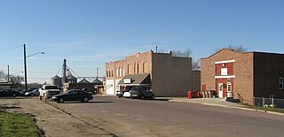
Hettinger is a city in, and the county seat of, Adams County, North Dakota, United States. The population was 1,074 at the 2020 census.

<span class="mw-page-title-main">Brinsmade, North Dakota</span> City in North Dakota, United States

For people with the surname, see Brinsmade (surname).

<span class="mw-page-title-main">Knox, North Dakota</span> City in North Dakota, United States

Knox is a city in Benson County, North Dakota, United States. The population was 22 at the 2020 census. Knox was founded in 1887.

<span class="mw-page-title-main">Oberon, North Dakota</span> City in North Dakota, United States

Oberon is a city in Benson County, North Dakota, United States. The population was 101 at the 2020 census. Oberon was founded in 1886.

<span class="mw-page-title-main">Warwick, North Dakota</span> City in North Dakota, United States

Warwick is a city in Benson County, North Dakota, United States. The population was 55 at the 2020 census. Warwick was founded in 1907.

<span class="mw-page-title-main">Page, North Dakota</span> City in North Dakota, United States

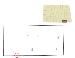
Page is a city in Cass County, North Dakota, United States. The population was 190 at the 2020 census. Page was founded in 1882.

<span class="mw-page-title-main">Starkweather, North Dakota</span> City in North Dakota, United States

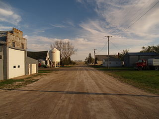
Starkweather is a city in Ramsey County, North Dakota, United States. The population was 100 at the 2020 census. Starkweather was founded in 1902.

<span class="mw-page-title-main">Hope, North Dakota</span> City in North Dakota, United States

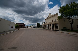
Hope is a city in Steele County, North Dakota, United States. The population was 272 at the 2020 census. Hope was founded in 1881.

<span class="mw-page-title-main">Waubay, South Dakota</span> City in South Dakota, United States

Waubay is a city in Day County, South Dakota, United States. The population was 473 at the 2020 census.

<span class="mw-page-title-main">Webster, South Dakota</span> City in South Dakota, United States

Webster is a city in and the county seat of Day County, South Dakota, United States. The population was 1,728 at the 2020 census.

<span class="mw-page-title-main">Parkston, South Dakota</span> City in South Dakota, United States

Parkston is a city in Hutchinson County, South Dakota, United States. The population was 1,567 at the 2020 census.

<span class="mw-page-title-main">Lennox, South Dakota</span> City in South Dakota, United States

Lennox is a city in Lincoln County, South Dakota, United States, located 20 miles (32 km) southwest of Sioux Falls. The population was 2,423 at the 2020 census.

<span class="mw-page-title-main">Tea, South Dakota</span> City in South Dakota, United States

Tea is a city in Lincoln County, South Dakota, United States and is a suburb of Sioux Falls. The population was 5,598 at the 2020 census.

<span class="mw-page-title-main">Leola, South Dakota</span> City in South Dakota, United States

Leola is a small city in, and the county seat of, McPherson County, South Dakota, United States. It was founded on May 1, 1884, and named for Leola Haynes, daughter of one of the town's founders. The population was 434 as of the 2020 census.

<span class="mw-page-title-main">Baltic, South Dakota</span> City in South Dakota, United States

Baltic is a city on the Big Sioux River in northern Minnehaha County, South Dakota, United States. The population was 1,246 at the 2020 census.

<span class="mw-page-title-main">Crooks, South Dakota</span> City in South Dakota, United States

Crooks is a city in Minnehaha County, South Dakota, United States and is a suburb of Sioux Falls. The population was 1,362 at the 2020 census. Crooks was named New Hope until 1904. The town's present name honors W. A. Crooks, a local politician.

<span class="mw-page-title-main">Garretson, South Dakota</span> City in South Dakota, United States

Garretson is a city in Minnehaha County, South Dakota, United States. The city had a population of 1,228 at the 2020 census.

<span class="mw-page-title-main">Mission, South Dakota</span> City in South Dakota, United States

Mission is a city on the Rosebud Indian Reservation in northern Todd County, South Dakota, United States. The population was 1,156 at the 2020 census.

<span class="mw-page-title-main">Elk Point, South Dakota</span> City in South Dakota, United States

Elk Point is a city in and county seat of Union County, South Dakota, United States. The population was 2,149 as of the 2020 census.

<span class="mw-page-title-main">Eagle Butte, South Dakota</span> City in South Dakota, United States

Eagle Butte is a city in Dewey and Ziebach counties in South Dakota, United States. The population was 1,258 at the 2020 census.

References

  1. "ArcGIS REST Services Directory". United States Census Bureau. Retrieved September 20, 2022.
  2. 1 2 U.S. Geological Survey Geographic Names Information System: Forbes, North Dakota
  3. 1 2 "Explore Census Data". United States Census Bureau . Retrieved July 23, 2022.
  4. "US Gazetteer files 2010". United States Census Bureau. Archived from the original on January 25, 2012. Retrieved June 14, 2012.
  5. "City and Town Population Totals: 2020-2021". United States Census Bureau. July 23, 2022. Retrieved July 23, 2022.
  6. United States Census Bureau. "Census of Population and Housing" . Retrieved January 30, 2014.
  7. "2020 CENSUS - SCHOOL DISTRICT REFERENCE MAP: Dickey County, ND" (PDF). United States Census Bureau . Retrieved August 23, 2021.