National Register of Historic Places listings in Burleigh County, North Dakota

Last updated

Location of Burleigh County in North Dakota Map of North Dakota highlighting Burleigh County.svg
Location of Burleigh County in North Dakota

This is a list of the National Register of Historic Places listings in Burleigh County, North Dakota.

Contents

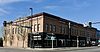
This is intended to be a complete list of the properties and districts on the National Register of Historic Places in Burleigh County, North Dakota, United States. The locations of National Register properties and districts for which the latitude and longitude coordinates are included below, may be seen in a map. [1]

There are 27 properties and districts listed on the National Register in the county, including 1 National Historic Landmark. Another 5 properties were once listed but have been removed.

Map all coordinates using: OpenStreetMap  
Download coordinates as: KML
Contents: Counties in North Dakota
Adams | Barnes | Benson | Billings | Bottineau | Bowman | Burke | Burleigh | Cass | Cavalier | Dickey | Divide | Dunn | Eddy | Emmons | Foster | Golden Valley | Grand Forks | Grant | Griggs | Hettinger | Kidder | LaMoure | Logan | McHenry | McIntosh | McKenzie | McLean | Mercer | Morton | Mountrail | Nelson | Oliver | Pembina | Pierce | Ramsey | Ransom | Renville | Richland | Rolette | Sargent | Sheridan | Sioux | Slope | Stark | Steele | Stutsman | Towner | Traill | Walsh | Ward | Wells | Williams


    This National Park Service list is complete through NPS recent listings posted September 30, 2022. [2]

Current listings

[3] Name on the RegisterImageDate listed [4] Location City or townDescription
1 Bismarck Cathedral Area Historic District
Bismarck Cathedral Area Historic District Cathedral of the Holy Spirit Bismarck, N.D.jpg
Bismarck Cathedral Area Historic District
May 8, 1980
(#80002908)
Roughly bounded by Hannifan and N. 1st Sts. and Aves. C and A, W.; also roughly along N. 1st, N. Mandan, N. Washington, and N. Raymond Sts., and Aves. C, D, and E, W.; also 104, 106, 112, 115, 116, and 120 E. Ave B and 523 N. 1st St. (but removing 316 and 320 W. Ave. A and 510 N. Washington St.)
46°48′37″N100°47′36″W / 46.810278°N 100.793333°W / 46.810278; -100.793333 (Bismarck Cathedral Area Historic District)
Bismarck Second and third sets of addresses represent boundary increases
2 Bismarck Civic Auditorium
Bismarck Civic Auditorium Bismarck Civic Auditorium.jpg
Bismarck Civic Auditorium
June 7, 1976
(#76001351)
201 N. 6th St.
46°48′24″N100°46′56″W / 46.806667°N 100.782222°W / 46.806667; -100.782222 (Bismarck Civic Auditorium)
Bismarck
3 Bismarck Tribune Building
Bismarck Tribune Building Bismarck Tribune Building.jpg
Bismarck Tribune Building
October 22, 1982
(#82001309)
22 N. 4th St.
46°48′26″N100°47′10″W / 46.807222°N 100.786111°W / 46.807222; -100.786111 (Bismarck Tribune Building)
Bismarck
4 Dr. Albert M. and Evelyn M. Brandt House
Dr. Albert M. and Evelyn M. Brandt House Dr. Alberts M. And Evelyn M. Brandt House.jpg
Dr. Albert M. and Evelyn M. Brandt House
August 16, 2000
(#00000992)
323 E. Ave. B
46°48′01″N100°47′09″W / 46.800278°N 100.785833°W / 46.800278; -100.785833 (Dr. Albert M. and Evelyn M. Brandt House)
Bismarck
5 Burleigh County Courthouse
Burleigh County Courthouse BurleighCoCourthouseND.jpg
Burleigh County Courthouse
November 14, 1985
(#85002980)
E. Thayer Ave.
46°48′28″N100°47′01″W / 46.807778°N 100.783611°W / 46.807778; -100.783611 (Burleigh County Courthouse)
Bismarck
6 Camp Hancock Site
Camp Hancock Site CAMP HANCOCK SITE.jpg
Camp Hancock Site
February 23, 1972
(#72001004)
101 Main Ave.
46°48′19″N100°47′30″W / 46.805278°N 100.791667°W / 46.805278; -100.791667 (Camp Hancock Site)
Bismarck
7 Chief Looking's Village site (32BL3)
Chief Looking's Village site (32BL3) BismarckND ChiefLookingVillageSite1.jpg
Chief Looking's Village site (32BL3)
November 21, 1978
(#78001990)
Eastern edge of Pioneer Park
46°49′49″N100°49′46″W / 46.830278°N 100.829444°W / 46.830278; -100.829444 (Chief Looking's Village site (32BL3))
Bismarck
8 Depression Era Work Relief Construction Features at Double Ditch Indian Village Site State Historic Site
Depression Era Work Relief Construction Features at Double Ditch Indian Village Site State Historic Site DOUBLE DITCH EARTH LODGE VILLAGE SITE.jpg
Depression Era Work Relief Construction Features at Double Ditch Indian Village Site State Historic Site
November 5, 2014
(#14000896)
ND 1804
46°56′11″N100°54′04″W / 46.9365°N 100.9011°W / 46.9365; -100.9011 (Depression Era Work Relief Construction Features at Double Ditch Indian Village Site State Historic Site)
Bismarck vicinityFederal Relief Construction in North Dakota, 1931-1943, MPS
9 Depression Era Work Relief Construction Features at Menoken State Historic Site
Depression Era Work Relief Construction Features at Menoken State Historic Site MenokenSite Kiosk.jpg
Depression Era Work Relief Construction Features at Menoken State Historic Site
December 7, 2010
(#10000998)
171st St. and 32nd Ave. NE; 1.7 miles north of Menoken
46°50′29″N100°31′07″W / 46.841389°N 100.518611°W / 46.841389; -100.518611 (Depression Era Work Relief Construction Features at Menoken State Historic Site)
Menoken vicinityFederal Relief Construction in North Dakota, 1931-1943, MPS
10 Double Ditch Earth Lodge Village Site (32BL8)
Double Ditch Earth Lodge Village Site (32BL8) Double Ditch Aerial2.jpg
Double Ditch Earth Lodge Village Site (32BL8)
January 29, 1979
(#79001769)
Left bank of the Missouri River above Bismarck [5]
46°56′12″N100°54′04″W / 46.936667°N 100.901111°W / 46.936667; -100.901111 (Double Ditch Earth Lodge Village Site (32BL8))
Bismarck vicinity
11 Downtown Bismarck Historic District
Downtown Bismarck Historic District BismarckND DowntownHistoricDistrict.jpg
Downtown Bismarck Historic District
October 28, 2001
(#01001188)
Roughly bounded by Broadway and Thayer Aves., 5th St., Burlington and Santa Fe railroad line, and Washington and 2nd Sts.
46°48′12″N100°47′23″W / 46.803333°N 100.789722°W / 46.803333; -100.789722 (Downtown Bismarck Historic District)
Bismarck
12 Florence Lake School No. 3 November 1, 2011
(#11000786)
10 miles north of Wing off ND 14
47°16′20″N100°17′01″W / 47.2722°N 100.2837°W / 47.2722; -100.2837 (Florence Lake School No. 3)
Wing vicinity
13 Former North Dakota Executive Mansion
Former North Dakota Executive Mansion FormerGovernorResidenceND.jpg
Former North Dakota Executive Mansion
April 16, 1975
(#75001301)
320 Ave. B, E.
46°48′40″N100°47′10″W / 46.811111°N 100.786111°W / 46.811111; -100.786111 (Former North Dakota Executive Mansion)
Bismarck
14 Fred and Gladys Grady House
Fred and Gladys Grady House Fred and Gladys Grady House.jpg
Fred and Gladys Grady House
July 21, 2006
(#06000636)
414 E. Ave. F
46°48′56″N100°47′05″W / 46.815556°N 100.784722°W / 46.815556; -100.784722 (Fred and Gladys Grady House)
Bismarck
15 Highland Acres Historic District July 6, 2022
(#100007875)
Roughly bounded by Shafer St., Edwards Ave., the axis of Williams St., and South Highland Acres Rd.
46°49′02″N100°48′45″W / 46.8172°N 100.8125°W / 46.8172; -100.8125 (Highland Acres Historic District)
Bismarck
16 Oliver and Gertrude Lundquist House
Oliver and Gertrude Lundquist House Oliver and Gertrude Lundquist House.jpg
Oliver and Gertrude Lundquist House
July 21, 2006
(#06000637)
622 W. Thayer St.
46°48′29″N100°48′00″W / 46.808056°N 100.8°W / 46.808056; -100.8 (Oliver and Gertrude Lundquist House)
Bismarck
17 Menoken Indian Village Site
Menoken Indian Village Site Menoken Indian Village Site.jpg
Menoken Indian Village Site
October 15, 1966
(#66000599)
171 St. at 32nd Ave., NE. [6]
46°50′28″N100°31′06″W / 46.8412°N 100.5182°W / 46.8412; -100.5182 (Menoken Indian Village Site)
Menoken vicinity
18 Northern Pacific Railway Depot
Northern Pacific Railway Depot 2009-0521-ND-Bismarck-NorthernPacificdepot.jpg
Northern Pacific Railway Depot
September 19, 1977
(#77001022)
407 E. Main Ave.
46°48′18″N100°47′07″W / 46.805°N 100.785278°W / 46.805; -100.785278 (Northern Pacific Railway Depot)
Bismarck
19 Our Lady of the Annunciation Chapel at Annunciation Priory
Our Lady of the Annunciation Chapel at Annunciation Priory Our Lady of Annunciation Chapel.jpg
Our Lady of the Annunciation Chapel at Annunciation Priory
June 16, 2020
(#100005177)
7500 University Dr. (University of Mary)
46°43′18″N100°45′14″W / 46.7218°N 100.7538°W / 46.7218; -100.7538 (Our Lady of the Annunciation Chapel at Annunciation Priory)
Bismarck
20 Patterson Hotel
Patterson Hotel 2009-0521-CDNtrip049-ND-Bismarck-McKenziePatterson.jpg
Patterson Hotel
December 8, 1976
(#76001352)
422 E. Main Ave.
46°48′21″N100°47′05″W / 46.805833°N 100.784722°W / 46.805833; -100.784722 (Patterson Hotel)
Bismarck
21 E. G. Patterson Building
E. G. Patterson Building PattersonBldgND.jpg
E. G. Patterson Building
October 22, 1982
(#82001310)
412-414 Main St.
46°48′20″N100°47′05″W / 46.805556°N 100.784722°W / 46.805556; -100.784722 (E. G. Patterson Building)
Bismarck
22 St. George's Episcopal Memorial Church
St. George's Episcopal Memorial Church St George's Episcopal Church.jpg
St. George's Episcopal Memorial Church
October 5, 2021
(#100007065)
601 North 4th St.
46°48′39″N100°47′10″W / 46.8109°N 100.7860°W / 46.8109; -100.7860 (St. George's Episcopal Memorial Church)
Bismarck
23 Soo Hotel
Soo Hotel The Soo Hotel.jpg
Soo Hotel
May 9, 1983
(#83001927)
112-114 5th St., N.
46°48′21″N100°47′05″W / 46.805833°N 100.784722°W / 46.805833; -100.784722 (Soo Hotel)
Bismarck
24 Towne-Williams House
Towne-Williams House TOWNE-WILLIAMS HOUSE.jpg
Towne-Williams House
April 14, 1975
(#75001302)
722 7th St., N.
46°48′45″N100°46′53″W / 46.8125°N 100.781389°W / 46.8125; -100.781389 (Towne-Williams House)
Bismarck
25 U.S. Post Office and Courthouse
U.S. Post Office and Courthouse BismarckND FederalBuilding.jpg
U.S. Post Office and Courthouse
June 23, 1976
(#76001353)
304 E. Broadway
46°48′25″N100°47′13″W / 46.806944°N 100.786944°W / 46.806944; -100.786944 (U.S. Post Office and Courthouse)
Bismarck
26 Van Horn Hotel
Van Horn Hotel Van Horn Hotel.jpg
Van Horn Hotel
May 10, 1984
(#84002759)
114 N. 3rd St.
46°48′22″N100°47′16″W / 46.806111°N 100.787778°W / 46.806111; -100.787778 (Van Horn Hotel)
Bismarck
27 Webb Brothers Block
Webb Brothers Block Webb Brothers Block.jpg
Webb Brothers Block
October 13, 1983
(#83004060)
317 E. Main Ave.
46°48′19″N100°47′11″W / 46.805278°N 100.786389°W / 46.805278; -100.786389 (Webb Brothers Block)
Bismarck

Former listings

[3] Name on the RegisterImageDate listedDate removedLocationCity or townDescription
1 Bismarck Public Library December 7, 1977
(#77001020)
June 12, 1980519 E. Thayer Ave.
Bismarck Demolished in May 1980.
2 Fire Hall February 14, 1978
(#78001989)
June 12, 1980517 E. Thayer Ave.
Bismarck Demolished in May 1980.
3 James W. Foley House September 13, 1977
(#77001021)
January 31, 1994522 6th St.(Original location. Current location:)
46°48′26″N100°43′36″W / 46.807207°N 100.726710°W / 46.807207; -100.726710 (James W. Foley House)
Bismarck Delisted due to relocation to the Missouri Valley Fairgrounds on November 19, 1993. [7]
4 Liberty Memorial Bridge
Liberty Memorial Bridge Liberty Memorial Bridge, Spanning Missouri River at I-94, Bismarck (Burleigh County, North Dakota).jpg
Liberty Memorial Bridge
March 11, 1997
(#97000172)
March 25, 2009 Interstate 94 business loop, across the Missouri River
46°48′28″N100°49′21″W / 46.8078°N 100.8225°W / 46.8078; -100.8225 (Liberty Memorial Bridge)
Bismarck Imploded on October 6, 2008. [8]
5 Yegen House and Pioneer Grocery October 5, 1977
(#77001023)
February 1, 2011808-810 E. Main Ave.(Original location. Current location:)
46°48′25″N100°43′32″W / 46.806960°N 100.725506°W / 46.806960; -100.725506 (Yegen House and Pioneer Grocery)
Bismarck Delisted due to relocation to the Missouri Valley Farigrounds on April 20, 1993. [9]

See also

Related Research Articles

<span class="mw-page-title-main">National Register of Historic Places listings in Lackawanna County, Pennsylvania</span>

This is a list of the National Register of Historic Places listings in Lackawanna County, Pennsylvania.

<span class="mw-page-title-main">National Register of Historic Places listings in Pike County, Pennsylvania</span>

This is a list of the National Register of Historic Places listings in Pike County, Pennsylvania.

<span class="mw-page-title-main">National Register of Historic Places listings in Woodbury County, Iowa</span>

This is a list of the National Register of Historic Places listings in Woodbury County, Iowa.

<span class="mw-page-title-main">National Register of Historic Places listings in Cass County, North Dakota</span>

This is a list of the National Register of Historic Places listings in Cass County, North Dakota.

<span class="mw-page-title-main">National Register of Historic Places listings in Walsh County, North Dakota</span>

This is a list of the National Register of Historic Places listings in Walsh County, North Dakota.

<span class="mw-page-title-main">National Register of Historic Places listings in St. Joseph County, Indiana</span>

This is a list of the National Register of Historic Places listings in St. Joseph County, Indiana.

<span class="mw-page-title-main">National Register of Historic Places listings in Brookings County, South Dakota</span>

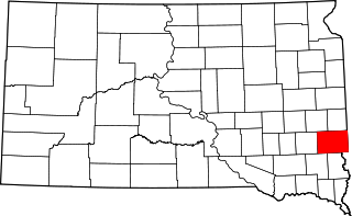
This is a list of the National Register of Historic Places listings in Brookings County, South Dakota.

<span class="mw-page-title-main">National Register of Historic Places listings in Lawrence County, South Dakota</span>

This is a list of the National Register of Historic Places listings in Lawrence County, South Dakota.

<span class="mw-page-title-main">National Register of Historic Places listings in Minnehaha County, South Dakota</span>

This is a list of the National Register of Historic Places listings in Minnehaha County, South Dakota.

<span class="mw-page-title-main">National Register of Historic Places listings in Pennington County, South Dakota</span>

This is a list of the National Register of Historic Places listings in Pennington County, South Dakota.

<span class="mw-page-title-main">National Register of Historic Places listings in Yankton County, South Dakota</span>

This is a list of the National Register of Historic Places listings in Yankton County, South Dakota.

<span class="mw-page-title-main">National Register of Historic Places listings in Brule County, South Dakota</span>

This is a list of the National Register of Historic Places listings in Brule County, South Dakota.

<span class="mw-page-title-main">National Register of Historic Places listings in Hughes County, South Dakota</span>

This is a list of the National Register of Historic Places listings in Hughes County, South Dakota.

<span class="mw-page-title-main">National Register of Historic Places listings in Jones County, South Dakota</span>

This is a list of the National Register of Historic Places listings in Jones County, South Dakota.

<span class="mw-page-title-main">National Register of Historic Places listings in Lyman County, South Dakota</span>

This is a list of the National Register of Historic Places listings in Lyman County, South Dakota.

<span class="mw-page-title-main">National Register of Historic Places listings in Meade County, South Dakota</span>

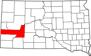
This is a list of the National Register of Historic Places listings in Meade County, South Dakota.

<span class="mw-page-title-main">National Register of Historic Places listings in Howard County, Indiana</span>

This is a list of the National Register of Historic Places listings in Howard County, Indiana.

<span class="mw-page-title-main">National Register of Historic Places listings in Grays Harbor County, Washington</span>

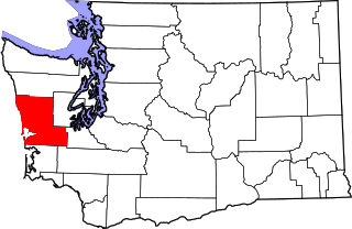
This is a list of the National Register of Historic Places listings in Grays Harbor County, Washington.

<span class="mw-page-title-main">National Register of Historic Places listings in Barnes County, North Dakota</span>

This is a list of the National Register of Historic Places listings in Barnes County, North Dakota.

<span class="mw-page-title-main">National Register of Historic Places listings in Tampa, Florida</span>

This is a list of the National Register of Historic Places listings in Tampa, Florida.

References

  1. The latitude and longitude information provided in this table was derived originally from the National Register Information System, which has been found to be fairly accurate for about 99% of listings. Some locations in this table may have been corrected to current GPS standards.
  2. National Park Service, United States Department of the Interior, "National Register of Historic Places: Weekly List Actions", retrieved September 30, 2022.
  3. 1 2 Numbers represent an alphabetical ordering by significant words. Various colorings, defined here, differentiate National Historic Landmarks and historic districts from other NRHP buildings, structures, sites or objects.
  4. The eight-digit number below each date is the number assigned to each location in the National Register Information System database, which can be viewed by clicking the number.
  5. Stewart, Frank H. "Mandan and Hidatsa Villages in the Eighteenth and Nineteenth Centuries". Plains Anthropologist 19.66 (1974): 287-302: 291.
  6. This location is derived from this Archived 2005-03-22 at the Wayback Machine National Park service website; the NRIS lists it as "Address Restricted"
  7. "Slow going". The Bismarck Tribune . November 20, 1993. p. 1. Retrieved August 11, 2022 via Newspapers.com.
  8. "Gone in seconds". The Bismarck Tribune . October 7, 2008. p. 7A. Retrieved August 11, 2008 via Newspapers.com.
  9. "History hits the road". The Bismarck Tribune . April 20, 1993. p. 6A. Retrieved August 11, 2022 via Newspapers.com.