The Toogee were an Aboriginal Tasmanian people who lived in Western Tasmania, Australia, before European settlement. Their Toogee people included Macquarie Harbour. [1]
The Toogee consisted of two different bands, the Lowreenne and Mimegin. [2] They made stone tools, including those from Darwin Glass, a natural glass formed from a meteorite impact. The archeological record for this region goes back to 20,000 years ago with relics found in the Kutikina Cave. They also left behind middens of shells along the coast.
The people living to the north near the Pieman River were the Peternidic band, and to the south near Port Davey was the Ninene.
A geological feature south of Tasmania is named after them, the Toogee sub basin. [3] This is in the northernmost part of the South Tasman Rise, adjacent to the Lowreenne Massif. [4]
| | This Indigenous Australians-related article is a stub. You can help Wikipedia by expanding it. |

Tasmania is an island state of Australia. It is located 240 kilometres (150 miles) to the south of the Australian mainland, separated from it by the Bass Strait, with the archipelago containing the southernmost point of the country. The state encompasses the main island of Tasmania, the 26th-largest island in the world, and the surrounding 1000 islands. It is Australia's least populous state, with 569,825 residents as of December 2021. The state capital and largest city is Hobart, with around 40 percent of the population living in the Greater Hobart area. This makes it Australia's most decentralised state.

Bass Strait is a strait separating the island state of Tasmania from the Australian mainland. The strait provides the most direct waterway between the Great Australian Bight and the Tasman Sea, and is also the only maritime route into the economically prominent Port Phillip Bay.

Southwest National Park is an Australian national park located in the south-west of Tasmania, bounded by the Franklin-Gordon Wild Rivers National Park to the north and the Hartz Mountains National Park to the east. It is a part of a chain of national parks and state reserves that make up the Tasmanian Wilderness World Heritage Area. Covering an area of 6,183 km2 (2,387 sq mi), it is Tasmania's largest national park.

The Tasman Peninsula, officially Turrakana / Tasman Peninsula, is a peninsula located in south-east Tasmania, Australia, approximately 75 km (47 mi) by the Arthur Highway, south-east of Hobart.
The history of Tasmania begins at the end of the Last Glacial Period when it is believed that the island was joined to the Australian mainland. Little is known of the human history of the island until the British colonisation of Tasmania in the 19th century.

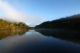
Macquarie Harbour is a shallow fjord in the West Coast region of Tasmania, Australia. It is approximately 315 square kilometres (122 sq mi), and has an average depth of 15 metres (49 ft), with deeper places up to 50 metres (160 ft). It is navigable by shallow-draft vessels. The main channel is kept clear by the presence of a rock wall on the outside of the channel's curve. This man-made wall prevents erosion and keeps the channel deep and narrow, rather than allowing the channel to become wide and shallow. A reported Aboriginal name for the harbour is Parralaongatek.

Zeehan is a town on the west coast of Tasmania, Australia 139 kilometres (86 mi) south-west of Burnie. It is part of the West Coast Council, along with the seaport Strahan and neighbouring mining towns of Rosebery and Queenstown.
The Pieman River is a major perennial river located in the west coast region of Tasmania, Australia.

The West Coast Range is a mountain range located in the West Coast region of Tasmania, Australia.

Frenchmans Cap is a mountain in the West Coast region of Tasmania, Australia. The mountain is situated in the Franklin-Gordon Wild Rivers National Park.
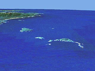
The Maatsuyker Islands are a group of islands and rocks 5.5 kilometres (3.4 mi) off the south coast of Tasmania, Australia. Maatsuyker Island is the southernmost island of the group and of the Australian continental shelf. There are exposed rocks further south of Maatsuyker but they do not meet the definition of "islands". Macquarie Island, far to the south, is also Australian territory but it is an upthrust piece of ocean floor in the remote Southern Ocean and is in a geological sense completely separate from the continent.

Cape Sorell is a headland located in the Southern Ocean outside Macquarie Harbour on the West Coast of Tasmania, Australia. The cape and the Cape Sorell Lighthouse, located above the headland, are important orientation points for all vessels entering the Macquarie Heads and then through Hells Gates at the entrance to the harbour.
Eaglehawk Neck, officially Teralina / Eaglehawk Neck, is a narrow isthmus that connects the Tasman Peninsula with the Forestier Peninsula and hence to the rest of Tasmania, Australia.

Tasmania Parks and Wildlife Service is the government body responsible for protected areas of Tasmania on public land, such as national parks, historic sites and regional reserves. Historically it has also had responsibility for managing wildlife, including game.
Port Davey is an oceanic inlet located in the south west region of Tasmania, Australia.
Mount Heemskirk is a mountain in Western Tasmania, west of the West Coast Range. It has an elevation of 751 metres (2,464 ft) above sea level. The closest town is Zeehan, about 14 kilometres (9 mi) away.

The geology of Tasmania is complex, with the world's biggest exposure of diabase, or dolerite. The rock record contains representatives of each period of the Neoproterozoic, Paleozoic, Mesozoic and Cenozoic eras. It is one of the few southern hemisphere areas that were glaciated during the Pleistocene with glacial landforms in the higher parts. The west coast region hosts significant mineralisation and numerous active and historic mines.

Mount Zeehan is a mountain in Western Tasmania, west of the West Coast Range. It has an elevation of 701 metres (2,300 ft) above sea level. The closest town is Zeehan, about 4.93 kilometres (3 mi) away.
Southwestern Tasmanian, or Toogee, is a possible aboriginal language of Tasmania. It is the most poorly attested known variety of Tasmanian, and it is not clear how distinct it was. It was apparently spoken along the west coast of the island, south of Macquarie Harbour.