Toorak railway station

Last updated

Toorak
PTV commuter rail station
Toorak Railway Station.jpg
Southbound view from Platform 1, June 2014
General information
LocationBeatty Avenue,
Armadale, Victoria
City of Stonnington
Australia
Coordinates 37°51′04″S145°00′50″E / 37.8510°S 145.0140°E / -37.8510; 145.0140
Owned by VicTrack
Operated by Metro Trains
Line(s) Frankston
Distance7.91 kilometres from
Southern Cross
Platforms4 (2 side, 1 island)
Tracks4
Connections
  • Melbourne tram logo.svg Tram
  • Victoria bus logo.svg Bus
Construction
Structure typeBelow-grade
AccessibleNo—steep ramp
Other information
StatusOperational, unstaffed
Station codeTOR
Fare zone Myki Zone 1
Website Public Transport Victoria
History
OpenedMay 7, 1879;145 years ago (1879-05-07)
Rebuilt1914
ElectrifiedMarch 1922 (1500 V DC overhead)
Passengers
2017–2018554,692 [1]
Preceding station Melbourne train logo.svg Metro Trains Following station
Hawksburn Frankston line Armadale
towards Frankston
      Pakenham line does not stop here
      Cranbourne line does not stop here

Toorak railway station is a commuter railway station on the northern boundary of Armadale, a suburb of Melbourne, Victoria, Australia. [3] The station is listed on the Victorian Heritage Register, and was opened on 7 May 1879. [4] The station is named after the nearby suburb of Toorak—located north of the station. The station consists of an island platform and two side platforms all accessed by a pedestrian bridge. There are two principal station buildings located on the central platform (platforms 2 and 3) and on platform 4, consisting of a small two and one-story brick buildings. [5] These buildings were provided in 1914, as ticketing and staff offices. The station is only partially accessible due to a multiple steep access ramps. [6]

Contents

Toorak railway station is served by the Frankston line, part of the Melbourne railway network. [3] The station also connects to the Route 72 tram service and the route 604 and 605 bus services. [7] [8] [9] The journey to Flinders Street railway station is approximately 6.5 kilometres (4.04 mi) and takes 11 minutes. [10]

Description

Toorak railway station is on the boundary of Armadale, Toorak, and Prahran suburbs of Melbourne, Victoria. The station is located nearby to the Beatty Avenue shopping precinct, Orrong Romanis Reserve, and Toorak Park. [11] The station is owned by VicTrack, a state government agency, and the station is operated by Metro Trains. [12] The station is approximately 6.5 kilometres (4.04 mi), or an 11-minute train journey, from Flinders Street station. [10] The adjacent stations are Hawksburn station up towards Melbourne, and Armadale station down towards Frankston. [3]

The station consists of a single island platform and two side platforms with a total of four platform edges. Standard in Melbourne, the platform has an asphalt surface with concrete on the edges. The platforms are approximately 160 metres (524.93 ft) long, enough for a Metro Trains 7 car HCMT. [4] The station features a pedestrian bridge, accessed from the centre of the platforms by a ramp. [13] The station features two principal station buildings, both former ticketing offices which are now heritage listed staff facilities. Distinct Edwardian architectural features of the red brick station buildings include ornate parapets, cement banding, tall chimneys with terracotta pots, tiled hip roof with terracotta finials, and stucco walls. [14] [15]

The station building, platform, and overpass are largely the same as when originally built, with the main change being updated signage, technology, and the addition of two new platform canopy amongst other minor building and platform upgrades. [16] There is no car parking available at the station. The station is listed as an "assisted access" station on the Metro Trains website, as the access ramp is too steep and would require assistance for wheelchair customers to traverse. [12]

History

A city-bound Comeng train arriving on Platform 1 in 2022. This platform was constructed as part of level crossing removal works in 1914. Citybound Comeng at Toorak.jpg
A city-bound Comeng train arriving on Platform 1 in 2022. This platform was constructed as part of level crossing removal works in 1914.

Toorak railway station was opened on 7 May 1879, with the station consisting of a single platform and track for commuter and freight service. [4] Like the adjacent suburb itself, the station was named after Toorak House, built by merchant James Jackson in 1849. The name is believed to be an Indigenous word meaning 'reedy swamp' or 'black crow'. [17] The first station buildings were opened on the site between 1881 and 1883 to coincide with the duplication of track between the city and Oakleigh. [4] The current station was constructed in 1914 to provide improved and additional facilities to what had become an increasingly busy and important location on the train network. The station rebuild was part of level crossing removal works that removed all level crossings, rebuilt all stations, and quadruplicated the corridor between South Yarra and Caulfield by 1914. [4] Later in 1922, the line was electrified using 1500 V DC overhead wires with three position signalling also introduced. [4]

In 1976, debate regarding the name of the station occurred as the station is located in the nearby suburb of Armadale. Suggestions were made about renaming the station, including naming the station after Albert Jacka, Australia's first recipient of the Victoria Cross, who was mayor of the former St Kilda Council. [18] These calls never eventuated, with Toorak station retaining its name with little conversation regarding its naming taking place since.

The station has mostly stayed the same since 1914, with only minor upgrades taking place. In 1972, the island platform (Platforms 2 and 3) was extended at both ends. [19] In 1977, a former goods siding and associated point work were permanently closed before being removed due to limited use. [20] In 1993, major re-signalling works occurred between Toorak and Caulfield stations. [4] The station underwent minor upgrades with the installation of two new shelters on Platform 1 in the 2010s. In 2021, resignalling works occurred to upgrade the corridor to high capacity signalling as part of the Metro Tunnel project. [21]

In the mid-2010s, rezoning by Stonnington Council allowed for higher density development next to Toorak station. This allowed for the construction of 446 apartments and 18 townhouses across numerous towers by developer Lendlease. [22] These towers have contributed to an increase in patronage and added density on an otherwise under-utilised site. [23]

Platforms and services

Toorak has two side platforms and one island platform with four faces. The station is currently served by the Frankston line—a service on the metropolitan rail network. [24] The Frankston line runs from Frankston station south east of Melbourne, joining the Cranbourne and Pakenham lines at Caulfield station before continuing onto the Werribee or Williamstown lines via Flinders Street station. [24] Despite the Pakenham and Cranbourne lines operating through the station, these services no longer stop at the station due to low station patronage, instead running express through the station. [25]

Platform 1:

Platform 2:

Platform 3:

Platform 4:

Toorak station has one tram and two bus connections. The route 72 tram service operates from nearby Malvern Road up towards the city and down towards Camberwell. [7] The station also connects to the route 605 bus service from Gardenvale to the Melbourne CBD (on Queen Street) [9] and the route 604 bus from Gardenvale to The Alfred Hospital. [8] The station does not have an accessible tram platform or a bus interchange, and instead is operated through on-street bus and tram stops. Toorak station also has train replacement bus stops located adjacent to the station.

Tram connections:

Bus connections:

Related Research Articles

<span class="mw-page-title-main">City Loop</span> Rail tunnel through the Melbourne CBD

The City Loop is a piece of underground commuter rail infrastructure in the central business district (CBD) of Melbourne, Victoria, Australia

<span class="mw-page-title-main">Richmond railway station, Melbourne</span> Railway station in Melbourne, Australia

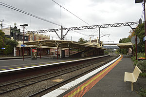
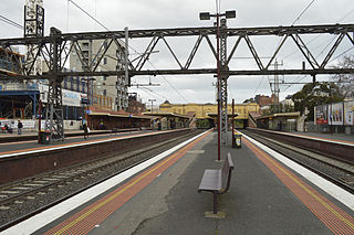
Richmond railway station is a commuter railway station and the junction point for the Alamein, Belgrave, Cranbourne, Frankston, Glen Waverley, Lilydale, Pakenham and Sandringham lines, serving the south-eastern inner Melbourne suburb of Richmond, Victoria, Australia. Richmond is a premium status elevated structure station featuring ten platforms, with five island platforms. The stations opened on 8 February 1859 as Punt Road before being renamed Swan Street on 12 December of the same year, it was renamed Richmond on 1 January 1867.

<span class="mw-page-title-main">Parliament railway station</span> Railway station in Melbourne, Victoria, Australia

Parliament railway station is a commuter railway station adjacent to the border between the Melbourne CBD and the suburb of East Melbourne, in Victoria, Australia. The station has two island platforms in a two-floor configuration, connected to street level via two underground concourses.

<span class="mw-page-title-main">South Yarra railway station</span> Railway station in Melbourne, Australia

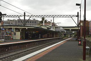
South Yarra railway station is a commuter railway station and the junction point for the Cranbourne, Frankston, Pakenham and Sandringham lines, serving the south Melbourne suburb of South Yarra, Victoria, Australia. South Yarra is a premium status ground structure station featuring six platforms, with two island platforms and two side platforms connected by a ramp accessible overground concourse. The station opened on 22 December 1860 as Gardiners Creek Road before being renamed South Yarra on 1 January 1867.

<span class="mw-page-title-main">Hawksburn railway station</span> Railway station in Melbourne, Australia

Hawksburn railway station is a commuter railway station on the Frankston line, serving the south Melbourne suburb of South Yarra, Victoria, Australia. Hawksburn is an unstaffed status below ground structure station featuring four platforms, with an island platform and two side platforms all accessed by a pedestrian bridge. The station is listed on the Victorian Heritage Register, and was opened on 7 May 1879, with the stations’ namesake being the locality of Hawksburn, 600 metres from the station. The station is only partially accessible due to multiple steep access ramps.

<span class="mw-page-title-main">Armadale railway station, Melbourne</span> Railway station in Melbourne, Australia

Armadale railway station is a commuter railway station in Armadale, a suburb of Melbourne, Victoria, Australia. The station is listed on the Victorian Heritage Register and was opened on 7 May 1879. The station consists of an island platform and two side platforms, all accessed by a pedestrian bridge. There are two principal station buildings located on the central platform and on platform 4, consisting of a small two and one-story brick buildings. These buildings were provided in 1914 as ticketing and staff offices. The station is only partially accessible due to a multiple steep access ramps.

<span class="mw-page-title-main">Malvern railway station, Melbourne</span> Railway station in Melbourne, Australia

Malvern railway station is a commuter railway station that is part of the Melbourne railway network in Victoria, Australia. The station is located on the southern border of Malvern, a suburb of Melbourne, and was opened on 7 May 1879. The station complex consists of an island platform and two side platforms all accessed by a pedestrian bridge. There are two red brick Edwardian-era station buildings, constructed in 1914 as ticketing and staff offices. The entire complex is listed on the Victorian Heritage Register because of its architectural significance and its role in the development of Malvern as a significant metropolitan centre. The station is only partially accessible because of multiple steep access ramps.

<span class="mw-page-title-main">Caulfield railway station</span> Railway station in Melbourne, Australia

Caulfield railway station is a commuter railway station on the northern boundary of Caulfield East, a suburb of Melbourne, Victoria, Australia. Opened in 1879 and rebuilt from 1913 to 1914, the station complex is listed on the Victorian Heritage Register and is noted as an example of Federation Free Style architecture. It is named after the nearby suburb of Caulfield, located southwest of the station.

<span class="mw-page-title-main">Frankston railway station</span> Railway station in Melbourne, Australia

Frankston railway station, in Victoria, Australia, is the terminus of the suburban electrified Frankston line and diesel-hauled services on the Stony Point line. It serves the south-eastern Melbourne suburb of Frankston, and opened on 1 August 1882.

<span class="mw-page-title-main">Carnegie railway station</span> Railway station in Melbourne, Australia

Carnegie railway station is a commuter railway station located in the suburb of Carnegie, in the southeastern suburbs of Melbourne, Victoria, Australia. The station originally opened in 1879 as Rosstown. The station received its current name in 1909 alongside the renaming of the suburb. The station consists of a single island platform connected to the station concourse on Koornang Road via escalators, lifts and a staircase.

<span class="mw-page-title-main">Murrumbeena railway station</span> Railway station in Melbourne, Australia

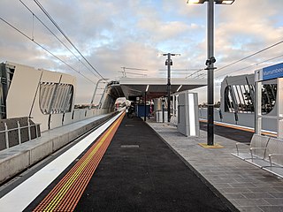
Murrumbeena railway station is located on the Pakenham and Cranbourne lines in Victoria, Australia. It serves the south-eastern Melbourne suburb of Murrumbeena, and it opened on 14 May 1879.

<span class="mw-page-title-main">Hughesdale railway station</span> Railway station in Melbourne, Australia

Hughesdale railway station is located on the Pakenham and Cranbourne lines in Victoria, Australia. It serves the south-eastern Melbourne suburb of Murrumbeena, and opened on 28 February 1925.

<span class="mw-page-title-main">Oakleigh railway station</span> Railway station in Melbourne, Australia

Oakleigh railway station is a commuter railway station in the suburb of Oakleigh in the south-east of Melbourne, Victoria, Australia. The station opened in 1877 as the up end of the Gippsland line, with the station being electrified in 1922. The station consists of two sides that are connected to each other via the adjacent roads, and both platforms are connected to each other via a pedestrian subway.

<span class="mw-page-title-main">Huntingdale railway station</span> Railway station in Melbourne, Australia

Huntingdale railway station is a commuter railway station located adjacent to the suburbs of Oakleigh and Huntingdale located in the south east of Melbourne, Victoria in Australia. The station originally opened in 1927 as "East Oakleigh". It did not receive its current name until 1954. The station consists of a single island platform connected to both Railway Avenue and Haughton Road via a pedestrian subway.

<span class="mw-page-title-main">Westall railway station</span> Railway station in Melbourne, Australia

Westall railway station is located on the Pakenham and Cranbourne lines in Victoria, Australia. It serves the south-eastern Melbourne suburb of Clayton South, and opened on 6 February 1951.

<span class="mw-page-title-main">Noble Park railway station</span> Railway station in Melbourne, Australia

Noble Park railway station is located on the Cranbourne and Pakenham lines in Victoria, Australia. It serves the south-eastern Melbourne suburb of Noble Park, and opened on 3 February 1913.

<span class="mw-page-title-main">Yarraman railway station</span> Railway station in Melbourne, Australia

Yarraman railway station is a minor commuter railway station on the Cranbourne and Pakenham lines of the metropolitan railway network in Victoria, Australia, located about 27 km (17 mi) from the Melbourne CBD. It serves neighbourhoods between the south-eastern Melbourne suburbs of Noble Park and Dandenong, and is named after the nearby Yarraman Creek, a first-order tributary of the lower Dandenong Creek/Patterson River system.

<span class="mw-page-title-main">Dandenong railway station</span> Railway station in Melbourne, Australia

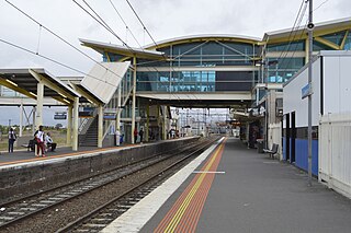
Dandenong railway station is the junction for the Cranbourne and Pakenham lines in Victoria, Australia. It serves the south-eastern Melbourne suburb of the same name, and opened on 8 October 1877.

<span class="mw-page-title-main">Gardenvale railway station</span> Railway station in Melbourne, Australia

Gardenvale railway station is located on the Sandringham line in Victoria, Australia. It serves the south-eastern Melbourne suburb of Brighton, and it opened on 10 December 1906.

<span class="mw-page-title-main">Pakenham line</span> Passenger rail service in metropolitan Melbourne, Victoria, Australia

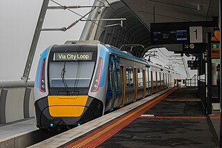
The Pakenham line is a commuter railway line in the city of Melbourne, Victoria, Australia. Operated by Metro Trains Melbourne, it is the city's longest metropolitan railway line at 57 kilometres (35 mi). The line runs from Flinders Street station in central Melbourne to Pakenham station in the south-east, serving 27 stations via the City Loop, South Yarra, Caulfield, Oakleigh, and Dandenong. The line operates for approximately 20 hours a day with 24 hour service available on Friday and Saturday nights. During peak hour, headways of up to 5 to 10 minutes are operated with services every 20 minutes during off-peak hours. Trains on the Pakenham line run with a seven-car formation operated by High Capacity Metro Trains.

References

  1. 1 2 3 4 Railway station and tram stop patronage in Victoria for 2008–2021 Philip Mallis
  2. Annual metropolitan train station patronage (station entries) Data Vic
  3. 1 2 3 Victoria, Public Transport. "Toorak Station". Public Transport Victoria. Retrieved 24 December 2022.
  4. 1 2 3 4 5 6 7 "VICSIG". vicsig.net. Retrieved 24 December 2022.
  5. "Toorak | Victorian Places". www.victorianplaces.com.au. Retrieved 24 December 2022.
  6. "Access Guide". www.metrotrains.com.au. Retrieved 24 December 2022.
  7. 1 2 3 "72 Melbourne University - Camberwell". Public Transport Victoria.
  8. 1 2 3 "604 Gardenvale - Alfred Hospital via Toorak Station". Public Transport Victoria.
  9. 1 2 3 "605 Gardenvale - Flagstaff Station". Public Transport Victoria.
  10. 1 2 Ltd, rome2rio Pty. "Flinders Street Station to Toorak – 7 ways to travel via , and train, and taxi". Rome2rio. Retrieved 24 December 2022.{{cite web}}: CS1 maint: numeric names: authors list (link)
  11. "Toorak Park (Armadale): All You Need to Know BEFORE You Go". Tripadvisor. Retrieved 24 December 2022.
  12. 1 2 "Toorak". www.metrotrains.com.au. Retrieved 24 December 2022.
  13. "MATHS stations". Daniel Bowen. 16 September 2008. Retrieved 24 December 2022.
  14. Toorak Village Precinct heritage.vic.gov.au Retrieved 31 March 2023
  15. Armadale Precinct heritage.vic.gov.au Retrieved 31 March 2023
  16. James Twining (8 January 2014). "Stonnington Council says train passengers at Toorak, Armadale, Malvern and Hawksburn could be worse off with future Melbourne Metro rail tunnel". Herald Sun. Retrieved 31 March 2023.
  17. Toorak Victorian Places
  18. "Works". Newsrail. Australian Railway Historical Society. June 1976. p. 138.
  19. "Way and Works". Divisional Diary . Australian Railway Historical Society. March 1972. p. 6.
  20. "Works". Newsrail. Australian Railway Historical Society. August 1977. p. 183.
  21. Build, Victoria’s Big (18 March 2022). "High Capacity Signalling". Victoria’s Big Build. Retrieved 24 December 2022.
  22. Lucas, Clay (10 May 2015). "A Forrest of towers: booming precinct goes from hundreds to thousands in decade". The Age. Retrieved 24 December 2022.
  23. "Toorak Park | DPG Property Group". www.dpgproperty.com. Retrieved 24 December 2022.
  24. 1 2 "Frankston Line". Public Transport Victoria.
  25. "New timetable train line information – Public Transport Victoria". 1 March 2021. Archived from the original on 1 March 2021. Retrieved 24 December 2022.{{cite web}}: CS1 maint: bot: original URL status unknown (link)

Commons-logo.svg Media related to Toorak railway station, Melbourne at Wikimedia Commons