Breaker Island is a small rocky island lying in Arthur Harbour close south-west of Norsel Point, off the south-west coast of Anvers Island in the Palmer Archipelago of Antarctica. It was surveyed by the Falkland Islands Dependencies Survey (FIDS) in 1955 and named by the UK Antarctic Place-Names Committee (UK-APC) because the island causes breakers when the sea is rough.
Cormorant Island is a 10 ha island lying in Bismarck Strait 1 km south of Anvers Island, 4 km (2.5 mi) east-south-east of Bonaparte Point, in the Palmer Archipelago of Antarctica. It lies some 5 km to the south-east of the United States' Palmer Station in Arthur Harbour on Anvers Island. It was shown on an Argentine government chart of 1954, but not named. It was named by the United Kingdom Antarctic Place-names Committee (UK-APC) in 1958 because of the large number of cormorants (shags) seen there.
Humble Island is a small rocky island lying 0.74 km (0.4 nmi) south-east of Norsel Point on Amsler Island, off the south-west coast of Anvers Island in the Palmer Archipelago of Antarctica. Humble Island was surveyed by the Falkland Islands Dependencies Survey (FIDS) in 1955. Humble Island was named by the United Kingdom Antarctic Place-names Committee (UK-APC) in 1956 because the island seems to be squeezed insignificantly between Litchfield Island and what was then considered the coast of Anvers Island.
Arthur Harbour is a small harbour entered between Bonaparte Point and Amsler Island on the south-west coast of Anvers Island in the Palmer Archipelago of Antarctica.

Litchfield Island is a rocky island 0.9 kilometres (0.5 nmi) long and rising to 50 m (164 ft), lying in Arthur Harbour, 0.9 kilometres (0.5 nmi) south of Norsel Point, off the south-west coast of Anvers Island in the Palmer Archipelago of Antarctica.

Smyley Island is an Antarctic island lying off the Antarctic Peninsula. The island is 61 km (38 mi) long and from 13 to 34 km wide, and lies about 20 km (12 mi) north of Case Island. It connects to the Stange Ice Shelf and is separated from Alexander Island by the Ronne Entrance. Smyley Island is one of the 27 islands of Palmer Land, Antarctica.
Maher Island is a small horseshoe-shaped island lying 10 km (6.2 mi) north of the north-western end of Siple Island, off the coast of Marie Byrd Land, Antarctica. It is one of the three pieces of land closest to the Oceanic Pole of Inaccessibility, also known as 'Point Nemo'. It has numerous areas of exposed rock and is mostly ice-free in summer.

Heywood Island is the largest of the islands off the north coast of Robert Island in the South Shetland Islands, Antarctica. It is named after Captain Peter Heywood, RN (1773–1831), commanding HMS Nereus off the east coast of South America in 1810–13, formerly a midshipman in HMS Bounty under Captain William Bligh. The area was visited by early 19th century sealers operating from nearby Clothier Harbour.

Caughley Beach is the northernmost beach on the ice-free coast south-west of Cape Bird, Ross Island, Antarctica. It was mapped by the New Zealand Geological Survey Antarctic Expedition, 1958–59, and named for Graeme Caughley, biologist with the party that visited Cape Bird. New College Valley, Antarctic Specially Protected Area (ASPA) No.116, lies above the beach.

Christoffersen Island is a small island immediately west of the southern end of Powell Island in the South Orkney Islands of Antarctica. The name appears on a chart by Norwegian whaling captain Petter Sorlle, who made a running survey of these islands in 1912–13.
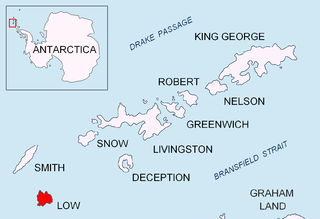
Jameson Point is a small headland on the north side of the entrance to Malina Cove, situated 6.3 km (3.9 mi) north of Cape Garry on the west side of Low Island, in the South Shetland Islands of Antarctica. It was roughly charted by the French Antarctic Expedition, 1908–10. The point was photographed from the air by the Falkland Islands and Dependencies Aerial Survey Expedition, 1955–57, and more accurately delineated from these photos by the Falkland Islands Dependencies Survey in 1959. The name "Jameson Island" was applied to Low Island by James Weddell in 1820–23, and Jameson Point has been approved for this point to preserve Weddell's name on Low Island.

Murray Island, also sometimes known as Bluff Island, is an island 6 mile long lying at the south-west side of Hughes Bay, off the west coast of Graham Land, Antarctica. The feature has been known to sealers operating in the area since the 1820s, although it was shown on charts as part of the mainland. In 1922 the whale catcher Graham passed through the channel separating it from the mainland, proving its insularity. It was named in association with Cape Murray, the seaward extremity of the island.

The Pearl Rocks are a group of rocks covering an area 6 km (3.7 mi) by 4 km (2.5 mi) close off the west coast of Tower Island in the Palmer Archipelago of Antarctica. The name was given by Falkland Islands and Dependencies Aerial Survey Expedition (FIDASE) (1955–57) and is descriptive of the numerous snow-covered rocks in the group.
Macklin Island is a small island in the eastern part of the Robinson Group, about 3 kilometres (1.5 nmi) north of Kirton Island, and 6 kilometres (3 nmi) northwest of Cape Daly, Mac. Robertson Land, Antarctica. It was mapped by Norwegian cartographers from air photos taken by the Lars Christensen Expedition, 1936–37, and was named by the Antarctic Names Committee of Australia for E.L. Macklin, a radio officer at Mawson Station in 1955 and 1959.
Kartografov Island is a small coastal island lying in the western part of the mouth of Harald Bay, Oates Land, Antarctica. It was photographed by U.S. Navy Operation Highjump (1946–47), the Soviet Antarctic Expedition (1957–58) and the Australian National Antarctic Research Expedition (1959). The island was named "Ostrov Kartografov" by the Soviet expedition.
Lagotellerie Island is an island 1.9 kilometres (1 nmi) long, lying 3.7 kilometres (2 nmi) west of Horseshoe Island in Marguerite Bay, off the west coast of Graham Land, Antarctica. It was discovered and named by the French Antarctic Expedition, 1908–10, under Jean-Baptiste Charcot.
The Rosenthal Islands are a group of about islands fringing the west coast of Anvers Island, 11 km (6.8 mi) north of Cape Monaco, in the Palmer Archipelago of Antarctica.
Lesser Mackellar Island is a small island immediately northeast of Greater Mackellar Island in the Mackellar Islands of Antarctica, lying 4 kilometres (2 nmi) north of Cape Denison in the center of Commonwealth Bay. It was discovered and named by the Australasian Antarctic Expedition (1911–14) under Douglas Mawson. The name is indicative of the size of the feature in relation to Greater Mackellar Island.

Sugarloaf Island is a conspicuous small island which lies close to the east side of Clarence Island, midway between Cape Lloyd and Cape Bowles, in the South Shetland Islands, Antarctica. It lies 3.2 km north of Lebed Point, on the northern side of the entrance to Istros Bay. The name was in use by American and British sealers as early as 1822 and is now well established.

The Ryder Bay Islands Important Bird Area is a 520 ha designated site on the south-east coast of Adelaide Island, Antarctica. It has been identified as an Important Bird Area (IBA) by BirdLife International because it supports significant numbers of breeding seabirds, notably south polar skuas. The site encompasses the Léonie Islands lying at the mouth of Ryder Bay, as well as Rothera Point, the eastern headland of the bay.
