
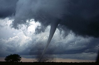
A tornado is a violently rotating column of air that is in contact with both the surface of the Earth and a cumulonimbus cloud or, in rare cases, the base of a cumulus cloud. It is often referred to as a twister, whirlwind or cyclone, although the word cyclone is used in meteorology to name a weather system with a low-pressure area in the center around which, from an observer looking down toward the surface of the Earth, winds blow counterclockwise in the Northern Hemisphere and clockwise in the Southern. Tornadoes come in many shapes and sizes, and they are often visible in the form of a condensation funnel originating from the base of a cumulonimbus cloud, with a cloud of rotating debris and dust beneath it. Most tornadoes have wind speeds less than 180 kilometers per hour, are about 80 meters across, and travel several kilometers before dissipating. The most extreme tornadoes can attain wind speeds of more than 480 kilometers per hour (300 mph), are more than 3 kilometers (2 mi) in diameter, and stay on the ground for more than 100 km (62 mi).

A supercell is a thunderstorm characterized by the presence of a mesocyclone, a deep, persistently rotating updraft. Due to this, these storms are sometimes referred to as rotating thunderstorms. Of the four classifications of thunderstorms, supercells are the overall least common and have the potential to be the most severe. Supercells are often isolated from other thunderstorms, and can dominate the local weather up to 32 kilometres (20 mi) away. They tend to last 2–4 hours.

On March 18, 1925, one of the deadliest tornado outbreaks in recorded history generated at least twelve significant tornadoes and spanned a large portion of the midwestern and southern United States. In all, at least 751 people were killed and more than 2,298 were injured, making the outbreak the deadliest tornado outbreak, March 18 the deadliest tornado day, and 1925 the deadliest tornado year in U.S. history. The outbreak generated several destructive tornadoes in Missouri, Illinois, and Indiana on the same day, as well as significant tornadoes in Alabama and Kansas. In addition to confirmed tornadoes, there were undoubtedly others with lesser impacts, the occurrences of which have been lost to history.
The 1999 Oklahoma tornado outbreak was a significant tornado outbreak that affected much of the Central and parts of the Eastern United States, with the highest record-breaking wind speeds of 301 ± 20 mph (484 ± 32 km/h). During this week-long event, 154 tornadoes touched down. More than half of them were on May 3 and 4 when activity reached its peak over Oklahoma, Kansas, Nebraska, Texas, and Arkansas.

This article lists various tornado records. The most "extreme" tornado in recorded history was the Tri-State tornado, which spread through parts of Missouri, Illinois, and Indiana on March 18, 1925. It is considered an F5 on the Fujita Scale, even though tornadoes were not ranked on any scale at the time. It holds records for longest path length at 219 miles (352 km), longest duration at about 3+1⁄2 hours, and it held the fastest forward speed for a significant tornado at 73 mph (117 km/h) anywhere on Earth until 2021. In addition, it is the deadliest single tornado in United States history with 695 fatalities. Tornadoes and violent thunderstorms cause deaths and property damage each year.The estimated U.S. insurance losses from severe thunderstorms in the first half of 2016 were $8.5 billion (US). It was also the third most costly tornado in history at the time, but has been surpassed by several others when non-normalized. When costs are normalized for wealth and inflation, it still ranks third today. In 2017, the primary goal was to locate and document at least a few unreported tornado damage pathways in highly forested areas of Ontario and Quebec as a proof of concept. In 2018, the scope was expanded to include two objectives: discover and document every EF1+ tornado in Ontario, as well as study noteworthy incidents in other parts of the province. Successes in each of these pilot projects led to a further increase of the NTP scope in 2019 to include the detection and documenting of all tornadoes in Canada.

A destructive and deadly tornado outbreak impacted the Red River Valley on April 10, 1979. Several strong to violent tornadoes touched down throughout the region that day. One F4 tornado impacted Vernon, Texas. The most notable tornado was another F4 tornado that destroyed most of the southern part of Wichita Falls, Texas, and is commonly referred to as "Terrible Tuesday" by many meteorologists. Additional tornadoes were reported across the Southern Plains as well as in the Mississippi River Valley on April 11–12. Overall, the outbreak killed 58 people and injured 1,927 others. This tornado outbreak resulted from a storm system that was the same storm system that, just a few days later, produced the 1979 Easter flood, which was the worst disaster to befall Jackson, Mississippi in over a century, causing over $500 million in 1979 dollars, forcing the evacuation of over 15,000 residents, and killing one.

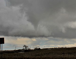
A wall cloud is a large, localized, persistent, and often abrupt lowering of cloud that develops beneath the surrounding base of a cumulonimbus cloud and from which tornadoes sometimes form. It is typically beneath the rain-free base (RFB) portion of a thunderstorm, and indicates the area of the strongest updraft within a storm. Rotating wall clouds are an indication of a mesocyclone in a thunderstorm; most strong tornadoes form from these. Many wall clouds do rotate; however, some do not.

A derecho is a widespread, long-lived, straight-line wind storm that is associated with a fast-moving group of severe thunderstorms known as a mesoscale convective system.

A tornado outbreak is the occurrence of multiple tornadoes spawned by the same synoptic scale weather system. The number of tornadoes required to qualify as an outbreak typically are at least six to ten, with at least two rotational locations or at least two supercells producing multiple tornadoes.
Tornadogenesis is the process by which a tornado forms. There are many types of tornadoes and these vary in methods of formation. Despite ongoing scientific study and high-profile research projects such as VORTEX, tornadogenesis is a volatile process and the intricacies of many of the mechanisms of tornado formation are still poorly understood.

The rear flank downdraft (RFD) is a region of dry air wrapping around the back of a mesocyclone in a supercell thunderstorm. These areas of descending air are thought to be essential in the production of many supercellular tornadoes. Large hail within the rear flank downdraft often shows up brightly as a hook on weather radar images, producing the characteristic hook echo, which often indicates the presence of a tornado.
A skipping tornado is a process tornado which has a discontinuous damage path.
Convective storm detection is the meteorological observation, and short-term prediction, of deep moist convection (DMC). DMC describes atmospheric conditions producing single or clusters of large vertical extension clouds ranging from cumulus congestus to cumulonimbus, the latter producing thunderstorms associated with lightning and thunder. Those two types of clouds can produce severe weather at the surface and aloft.

A satellite tornado is a tornado that revolves around a larger, primary tornado and interacts with the same mesocyclone. Satellite tornadoes occur apart from the primary tornado and are not considered subvortices; the primary tornado and satellite tornadoes are considered to be separate tornadoes. The cause of satellite tornadoes is not known. Such tornadoes are more often anticyclonic than are typical tornadoes and these pairs may be referred to as tornado couplets. Satellite tornadoes commonly occur in association with very powerful, large, and destructive tornadoes, indicative also of the strength and severity of the parent supercell thunderstorm.

Charles A. Doswell III is an American meteorologist and prolific severe convective storms researcher. Doswell is a seminal contributor, along with Leslie R. Lemon, to the modern conception of the supercell, which was developed originally by Keith Browning. He also has done research on forecasting and forecast verification, especially for severe convective storms, and is an advocate of ingredients-based forecasting.

The March 1990 Central United States tornado outbreak affected portions of the United States Great Plains and Midwest regions from Iowa to Texas from March 11 to March 13, 1990. The outbreak produced at least 64 tornadoes across the region, including four violent tornadoes; two tornadoes, which touched down north and west of Wichita, Kansas, were both rated F5, including the tornado that struck Hesston. In Nebraska, several strong tornadoes touched down across the southern and central portion of the state, including an F4 tornado that traveled for 131 miles (211 km) making it the longest tracked tornado in the outbreak. Two people were killed in the outbreak, one each by the two F5 tornadoes in Kansas.

The tornado outbreak sequence of May 25–June 1, 1917 was an eight-day tornado event, known as a tornado outbreak sequence, that killed at least 383 people, mostly in the Midwestern and parts of the Southeastern United States. It was the most intense and the longest continuous tornado outbreak sequence on record, with at least 66 tornadoes including 15 that were analyzed to have been violent (F4–F5) based upon reported damage. The deadliest tornado of the entire sequence produced a 155-mile (249 km) track across Illinois, killing 101 people and devastating the towns of Charleston and Mattoon along with small farming communities. Once believed to have traveled 290-mile (470 km) across Illinois and into Indiana, it is now assessed to have been a tornado family of four to eight separate tornadoes.
Leslie R. Lemon was an American meteorologist bridging research and forecasting with expertise in weather radar, particularly regarding severe convective storms. Lemon was, along with Charles A. Doswell III, a seminal contributor to the modern conception of the supercell convective storm which was first identified by Keith Browning, and he developed the Lemon technique to estimate updraft strength and thunderstorm organization also as a continuation of Browning's work.

Storm Data and Unusual Weather Phenomena (SD) is a monthly NOAA publication with comprehensive listings and detailed summaries of severe weather occurrences in the United States. Included is information on tornadoes, high wind events, hail, lightning, floods and flash floods, tropical cyclones (hurricanes), ice storms, snow, extreme temperatures such as heat waves and cold waves, droughts, and wildfires. Photographs of weather and attendant damage are used as much as possible. Maps of significant weather are also included.
