Torrance, East Dunbartonshire

Last updated

Torrance
Torrance from the air (geograph 2965680).jpg
Torrance with the River Kelvin in the foreground and Milton of Campsie and Lennoxtown in the background.
East Dunbartonshire UK location map.svg
Red pog.svg
Torrance
Location within East Dunbartonshire
Population2,320 (mid-2020 est.) [1]
OS grid reference NS6192974147
Civil parish
Council area
Lieutenancy area
Country Scotland
Sovereign state United Kingdom
Post town GLASGOW
Postcode district G64
Dialling code 01360
Police Scotland
Fire Scottish
Ambulance Scottish
UK Parliament
Scottish Parliament
List of places
UK
Scotland
55°56′26″N4°12′39″W / 55.940556°N 4.210833°W / 55.940556; -4.210833 Coordinates: 55°56′26″N4°12′39″W / 55.940556°N 4.210833°W / 55.940556; -4.210833

Torrance is a relatively affluent village in East Dunbartonshire, formerly Stirlingshire, Scotland, located eight miles (thirteen kilometres) north of Glasgow city centre. Torrance used to mainly consist of farmland. [2] The village was once famous as a resting place for workers on their way to the Campsie Fells four miles (six kilometres) north. The Forth and Clyde Canal has a wharf nearby at Hungryside, and the A807 runs along its southern edge. The village has an active community charity whose aims are to improve the village facilities.

Contents

History

Originally located in the county of Stirlingshire the name Torrance may come from the Gaelic for the place of the "little hillocks". [3]

There are Roman sites close to Torrance with a fort at Cadder and a fortlet at Glasgow Bridge.

The village of Torrance is located in "The Eleven Ploughs of Balgrochan". The "Eleven Ploughlands" are part of the estate of the Grahams of Mugdock, which had been feued in 1630 to local occupiers by the Marquess of Montrose. The feuars, originally holding their land unenclosed, each received an enclosed piece of land in 1735, as was common at the time. The village of Torrance developed some time later. [4]

Although weavers were among the earliest residents of the village, limestone, coal and ironstone extraction also began to emerge as a local industry. [4]

For several years, the canal wharf at Hungryside was Torrance's main connection with the outside world. However, this began to change in 1879 with the opening of Torrance railway station by the Kelvin Valley Railway Company. Before the coming of the railway the population of the area was around 800. [5]

Community

Local amenities

Torrance offers local amenities to its residents including one hairdresser, one beauty salon and barber, tennis courts, car valeting, mechanics, Scotmid, dentist, chiropodist, bakery, chemist, Chinese takeaway and newsagent and the Torrance Church of Scotland [6] at the foot of School Road and St Dominic's RC Church at the top.

Torrance has three pubs: the Wheatsheaf Inn, the Torrance Inn and the Rambler with another bar in the bowling club.

Torrance Primary School

The school has around 250 pupils. It has three sport pitches, one of them is rock, another red ash and another which is ash. Primary 7 pupils can transfer onto Boclair Academy in the nearby Bearsden or St Ninians High School in Kirkintilloch.

Torrance Initiative

Torrance Community Initiative is a registered charity aiming to provide new custom-built community facilities in the village.

The land held in "trust" by Torrance Community Initiative for the benefit of the community is a ten-acre (four-hectare) site. Unfortunately the planning permission granted in 1977 for a multi-use clubhouse for the former land owners - a boys' club, was never brought to fruition. The land was designated as Green Belt in the 1990s, although it forms an intrusion between two parts of the village and most people believed it was simply Greenfield, where legal restrictions on development are less severe. When people learned it was Green Belt, this became an emotive issue and the basis of the campaign against development.

Outline planning for the new community facilities was rejected by East Dunbartonshire council in May 2008. This included the residential development of 20–40 houses to fund for the community facilities on a 9+34-acre (3.9-hectare) site held in trust for the community by the Torrance Community Initiative. Reasons for rejection were that the land is designated greenbelt and the council had not yet done a long overdue review of current facilities as identified in the Local Plan. [7]

Crime

East Dunbartonshire has significantly lower recorded crime rates (40-50% lower for acquisitive and violent crime) than the average in Greater Glasgow and Clyde. [8]

Administration

Torrance is part of Ward 5 (known as Bishopbriggs North and Torrance) within East Dunbartonshire Council and is represented by three local councillors:

The MSP for Strathkelvin and Bearsden is Fiona McLeod of the Scottish National Party, who was elected on 5 May 2011.

Notable residents

Related Research Articles

<span class="mw-page-title-main">Milngavie</span> Town in Scotland

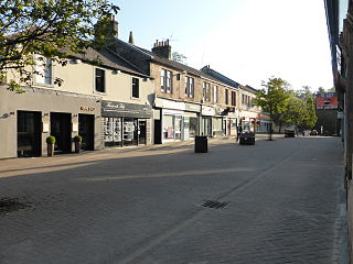
Milngavie is a town in East Dunbartonshire, Scotland and a suburb of Glasgow. It is on the Allander Water, at the northwestern edge of Greater Glasgow, and about 10 kilometres (6.2 mi) from Glasgow city centre. It neighbours Bearsden. Milngavie is a commuter town, with much of its working population travelling to Glasgow to work or study. The town is served by Milngavie railway station on the North Clyde Line of the SPT rail network, which links it to Central Glasgow.

<span class="mw-page-title-main">East Dunbartonshire</span> Council area of Scotland

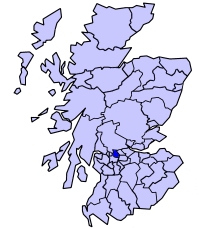
East Dunbartonshire is one of the 32 council areas of Scotland. It borders the north of Glasgow and contains many of the affluent areas to the north of the city, including Bearsden, Milngavie, Milton of Campsie, Balmore and Torrance, as well as many of the city's commuter towns and villages. East Dunbartonshire also shares borders with North Lanarkshire, Stirling and West Dunbartonshire. The council area covers parts of the historic counties of Dunbartonshire, Lanarkshire and Stirlingshire.

<span class="mw-page-title-main">Bishopbriggs</span> Town in Scotland

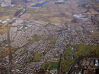
Bishopbriggs is a town in East Dunbartonshire, Scotland. It lies on the northern fringe of Greater Glasgow, approximately 4 miles (6 km) from the city centre. Historically in Lanarkshire, the area was once part of the historic parish of Cadder - originally lands granted by King William the Lion to the Bishop of Glasgow, Jocelin, in 1180. It was later part of the county of Lanarkshire, and then an independent burgh from 1964 to 1975. Today, Bishopbriggs' close geographic proximity to Glasgow now effectively makes it a suburb and commuter town of the city. The town's original Gaelic name Coille Dobhair reflects the name of the old parish of Cadder, but modern Gaelic usage uses Drochaid an Easbaig, a literal translation of Bishopbriggs. It was ranked the 2nd most desirable postcode in Scotland to live in following a study by the Centre for Economic and Business Research in 2015 and 2016.

<span class="mw-page-title-main">Dunbartonshire</span> Historic county in Scotland

Dunbartonshire or the County of Dumbarton is a historic county, lieutenancy area and registration county in the west central Lowlands of Scotland lying to the north of the River Clyde. Dunbartonshire borders Perthshire to the north, Stirlingshire to the east, Lanarkshire and Renfrewshire to the south, and Argyllshire to the west.

<span class="mw-page-title-main">Bearsden</span> Town in East Dunbartonshire, Scotland

Bearsden is a town in East Dunbartonshire, Scotland, on the northwestern fringe of Greater Glasgow. Approximately 6 miles (10 km) from Glasgow City Centre, the town is effectively a suburb, and its housing development coincided with the 1863 introduction of a railway line. The town was named after Bearsden railway station, which was named after a nearby cottage.

<span class="mw-page-title-main">Stirlingshire</span> Historic county in Scotland

Stirlingshire or the County of Stirling, Scottish Gaelic: Siorrachd Sruighlea) is a historic county and registration county of Scotland. Its county town is Stirling.

<span class="mw-page-title-main">Strathkelvin</span>

Strathkelvin is the strath (valley) of the River Kelvin in west central Scotland, lying north-east of Glasgow. The name Strathkelvin was used between 1975 and 1996 for one of nineteen local government districts in the Strathclyde region.

<span class="mw-page-title-main">Kirkintilloch</span> Human settlement in Scotland

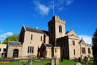
Kirkintilloch is a town and former barony burgh in East Dunbartonshire, Scotland. It lies on the Forth and Clyde Canal and on the south side of Strathkelvin, about 8 miles (13 km) northeast of central Glasgow. Historically part of Dunbartonshire, the town is the administrative home of East Dunbartonshire council area, its population in 2009 was estimated at 19,700 and its population in 2011 was 19,689.

<span class="mw-page-title-main">East Dunbartonshire (UK Parliament constituency)</span> Parliamentary constituency in the United Kingdom, 2005 onwards

East Dunbartonshire is a county constituency of the House of Commons of the Parliament of the United Kingdom (Westminster). It elects one Member of Parliament (MP) by the first past the post system of election. The seat is possibly best known for formerly being the constituency of Jo Swinson, the former Leader of the Liberal Democrats who was defeated at the 2019 general election. The current MP for the constituency is Amy Callaghan of the Scottish National Party (SNP).

<span class="mw-page-title-main">River Kelvin</span> River in Scotland

The River Kelvin is a tributary of the River Clyde in northern and northeastern Glasgow, Scotland. It rises on the moor south east of the village of Banton, east of Kilsyth. At almost 22 miles (35 km) long, it initially flows south to Dullatur Bog where it falls into a man made trench and takes a ninety degree turn flowing west through Strathkelvin and along the northern boundary of the bog parallel with the Forth and Clyde Canal.

<span class="mw-page-title-main">Twechar</span> Human settlement in Scotland

Twechar is a small former mining village historically in Dunbartonshire and administered by the council area of East Dunbartonshire, Scotland close to the boundary with North Lanarkshire. It lies between the larger towns of Cumbernauld, Kilsyth and Kirkintilloch. The Forth and Clyde Canal runs close to the village to the north, and closely follows the line of the Antonine Wall. There are visible remains of the wall on Bar Hill and the Roman Fort is a local tourist attraction.

<span class="mw-page-title-main">New Kilpatrick</span>

New Kilpatrick, is an ecclesiastical Parish and former Civil Parish in Dunbartonshire. It was formed in 1649 from the eastern half of the parish of Kilpatrick, the western half forming Old Kilpatrick. New Kilpatrick is also a disused name for the town of Bearsden.

Balmore is a small village formerly in the county of Stirlingshire, but now lies in East Dunbartonshire, Scotland, located 1 km west of Torrance and 5 km east of Milngavie.

The East Dunbartonshire Independent Alliance was a minor political party operating in East Dunbartonshire, Scotland, represented on East Dunbartonshire Council until October 2012 by Jack Young, one of the three councillors for Kirkintilloch East & Twechar, and until July 2012 by Charles Kennedy, one of the three councillors for Campsie & Kirkintilloch North.

Turnbull High School is a co-educational comprehensive secondary school located in Bishopbriggs, East Dunbartonshire, Scotland. The school was named after William Turnbull, Bishop of Glasgow from 1448 to 1454, and founder of the University of Glasgow in 1451, of which he was the first Chancellor. Whilst enrollment is open to pupils of all religious denominations and none, the School's religious ethos emphasises practice of Roman Catholic moral values both in the church and in the community, with its own Chaplain and many associated charitable and community-based activities undertaken.

<span class="mw-page-title-main">Boclair Academy</span> State secondary school in Bearsden, East Dunbartonshire, Scotland

Boclair Academy, a co-educational comprehensive secondary school located in the Greater Glasgow suburb of Bearsden, East Dunbartonshire, Scotland, serves pupils aged 11 to 18 from Southern Bearsden, Westerton and Torrance. Boclair Academy is affiliated with four local primary schools within its catchment area: Westerton Primary School, Killermont Primary School, Colquhoun Park Primary School and Torrance Primary School. The school's exam achievement has improved in recent years: in 2011 27% of S5 gained at least 5 Higher passes (A-C), ranking Boclair 11th in Scotland for a state school.

<span class="mw-page-title-main">Stewart MacDonald</span>

Stewart MacDonald is a Scottish Labour Party local government councillor. He was elected to the East Kirkintilloch and Twechar Ward of East Dunbartonshire Council in the 2007 election. He is also a member of Kirkintilloch Community Council and the Bridgeton Burns Club, and was a director of the East Dunbartonshire Municipal Bank between 2007 and 2015 and the East Dunbartonshire Leisure and Culture Trust from 2010 to the present.

The Kelvin Valley Railway was an independent railway designed to connect Kilsyth, an important mining town in central Scotland, with the railway network. It connected Kilsyth to Kirkintilloch and thence over other railways to the ironworks of Coatbridge, and to Maryhill, connecting onwards to the Queen's Dock at Stobcross.

<span class="mw-page-title-main">Torrance railway station</span> Former railway station in Scotland

Torrance railway station was opened in 1879 on the Kelvin Valley Railway and served the area of the village of Torrance in East Dunbartonshire until 1951 for passengers and 1959 for freight.

<span class="mw-page-title-main">Bearsden South (ward)</span> Local government ward of East Dunbartonshire

Bearsden South is one of the seven wards used to elect members of the East Dunbartonshire Council. It elects three Councillors. As its name suggests, its territory consists of the southern part of the burgh of Bearsden, with part of the boundary to the north following the path of the Antonine Wall; it also borders the Drumchapel housing estate in Glasgow – the marked differences in average life expectancy and other factors between residents living in close proximity in the two areas has been remarked upon in various studies.

References

  1. "Mid-2020 Population Estimates for Settlements and Localities in Scotland". National Records of Scotland. 31 March 2022. Retrieved 31 March 2022.
  2. "OS 25 inch 1892-1949". National Library of Scotland. Ordnance Survey. Retrieved 26 October 2017.
  3. Drummond, Peter, John (2014). An analysis of toponyms and toponymic patterns in eight parishes of the upper Kelvin basin (PDF). Glasgow: Glasgow University. p. 214. Retrieved 3 July 2017.
  4. 1 2 "History of Torrance". TorranceWeb. TorranceWeb. Archived from the original on 4 February 2012. Retrieved 17 May 2011.
  5. Lee, Robert (1845). The new statistical account of Scotland (Vol 8 ed.). Edinburgh and London: W. Blackwood and Sons. pp. 158–263. Retrieved 11 February 2018.
  6. "Torrance Parish Church". Tpc.org.uk. Retrieved 30 August 2015.
  7. "About TCI". 55.9407933948127;-4.20464158058167: Torrance Community Initiative. 21 September 2013. Retrieved 30 August 2015.{{cite web}}: CS1 maint: location (link)
  8. Shipton D and Whyte B (2011). Mental Health in Focus : a profile of mental health and wellbeing in Greater Glasgow & Clyde. Glasgow Centre for Population Health. p. 8. Retrieved 23 November 2016.[ permanent dead link ]
  9. "New Star Wars filming to start in parts of the Highlands next month".
  10. "Vote for Tommy from Torrance". Kirkintilloch Herald. 16 January 2009. Retrieved 23 November 2016.
  11. 1 2 W. S. Pierpoint (22 April 1997). "Obituary: Norman Pirie - People - News". The Independent. Retrieved 30 August 2015.
  12. "Sally Magnusson's book in running for literary prize - Kirkintilloch Herald". M.kirkintilloch-herald.co.uk. 19 October 2014. Retrieved 30 August 2015.
  13. Fotheringham, Ann (20 April 2019). "Meet top Glasgow chef Mark Donald". Glasgow Evening Times . Retrieved 21 October 2019.
  14. Devine, Cate (27 June 2011). "Nobody trains chefs properly, they buy their ingredients ready-made". Glasgow Herald . Retrieved 21 October 2019.